NDG wrote:I just heard that if Michael makes landfall as a Cat 4 it will be the first time ever a Cat 4 makes landfall along the Panhandle.
This is a signal that its probably not going to be a CAT4 windspeed wise when it makes it onshore.
However it will be a CAT4 for all other aspects of a hurricane's impact. bob rulz wrote:Normally I would agree, but it's already at the point when most storms in the Gulf begin to weaken, but all signs right now point to continued weakening. On top of that, the convection is unusually intense for this part of the basin, which will likely help fuel higher windspeeds, and it's moving fairly quickly, which won't give it a lot of time to weaken. I could see it peaking like 3 or 4 hours before landfall, maybe, but I think any weakening will be modest at best. The conditions are there for this to strengthen right up until landfall moreso than other storms in this area I think.
Hurricane Katrina was a strong CAT5 at roughly the same timeframe as when Michael is at his current intensity to LF. Some believe Katrina was a CAT2 at its destination but I don't agree with that - however such a decrease in winds is very possible and is why I never believe it until 2 hours before landfall. This has been the case for virtually every non-small hurricane to date. I'm even more unconvinced with the way the eyewall is with its lopsided convection.
djones65 wrote:Cyclenall,
It's easy to "bet the farm on it," when you are in Ontario, Canada!!!!
Thank God you are here to reassure the people on the Florida Panhandle...
Hopefully you are right and you can put a feather in your cap for being "right" that the NHC is simply overwarning for no reason...
What am I reassuring them of? I'm in the camp of anyone living near the hurricane's LF forecast needs to evacuate immediately for this very devastating hurricane.
Separate impact from forecast landfall windspeeds.
Hypercane_Kyle wrote:Yea, this is officially horrifying. I could see a landfall intensity of around 150-160mph.
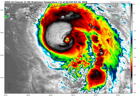
Looks like Camille in that shot.


 : Betsy, Camille, Elena, Georges, Katrina, Isaac, Zeta