ATL: FLORENCE - Post-Tropical - Discussion
Moderator: S2k Moderators
-
Bocadude85

- Category 5

- Posts: 2991
- Age: 39
- Joined: Mon Apr 18, 2005 2:20 pm
- Location: Honolulu,Hi
Re: ATL: FLORENCE - Hurricane - Discussion
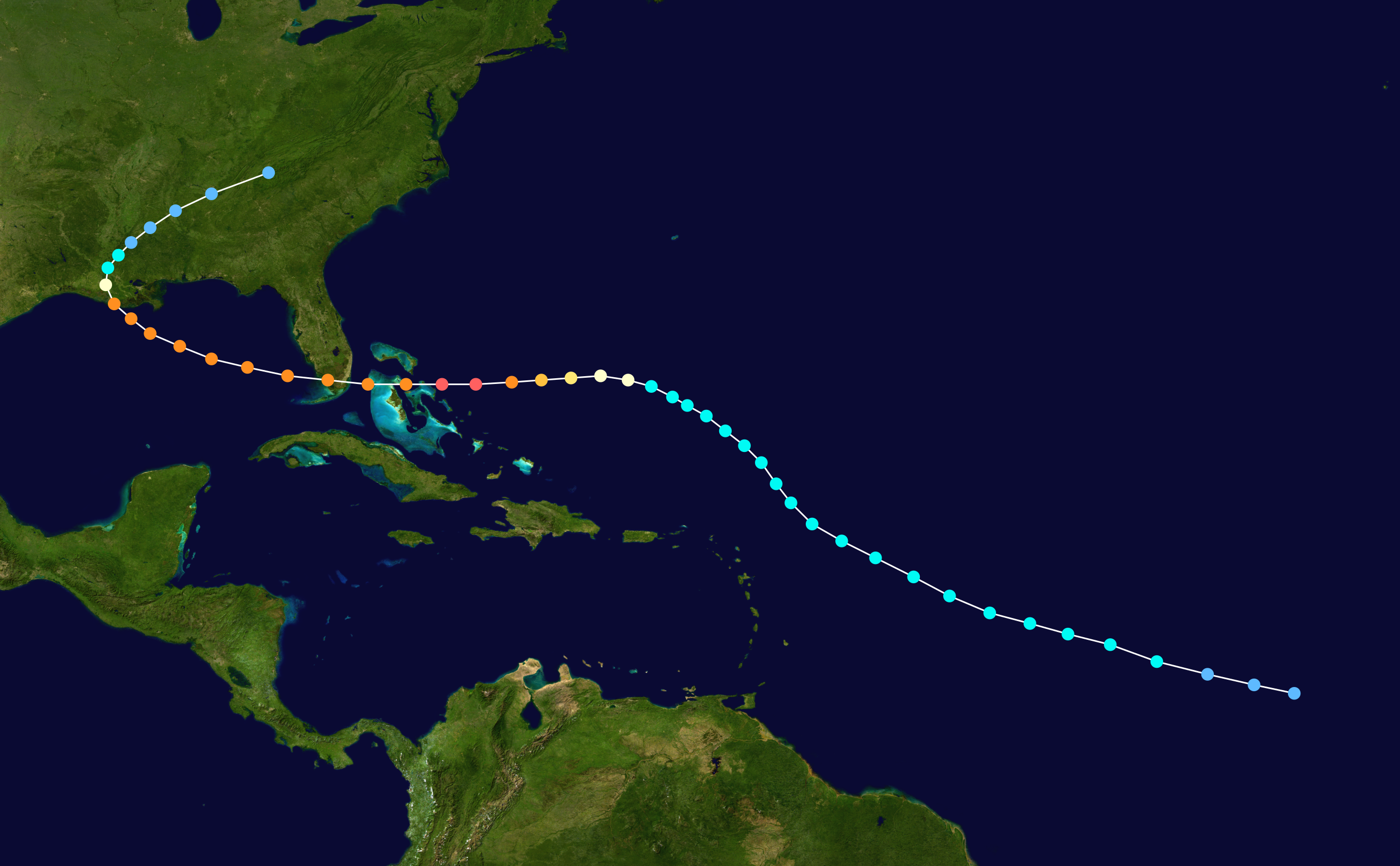
I am interested to see at what longitude Florence crosses 25N. It’s hard to imagine any hurricane crossing 25N before 50W and somehow impacting the USA. If she can make it to 60-65W before crossing 25N then I would say chances of a USA impact will increase.
0 likes
-
TheStormExpert
Re: ATL: FLORENCE - Hurricane - Discussion
Bocadude85 wrote:I am interested to see at what longitude Florence crosses 25N. It’s hard to imagine any hurricane crossing 25N before 50W and somehow impacting the USA. If she can make it to 60-65W before crossing 25N then I would say chances of a USA impact will increase.
In my opinion there is no way Florence makes it to 60-65W at or below 25N. Currently it’s at 22N and not even at 46W on a NW heading.
0 likes
-
Bocadude85
- Category 5
- Posts: 2991
- Age: 39
- Joined: Mon Apr 18, 2005 2:20 pm
- Location: Honolulu,Hi
Re: ATL: FLORENCE - Hurricane - Discussion
Florence continues to strengthen, 11am advisory has her at 110kts, this unexpected strength has to play some sort of role in the track, I would tend think the models will shift north and east overtime. But I have been proven wrong before.
0 likes
-
cycloneye

- Admin

- Posts: 149467
- Age: 69
- Joined: Thu Oct 10, 2002 10:54 am
- Location: San Juan, Puerto Rico
Re: ATL: FLORENCE - Advisories
Hurricane Florence Discussion Number 25
NWS National Hurricane Center Miami FL AL062018
1100 AM AST Wed Sep 05 2018
Remarkably, Florence has continued to strengthen. The hurricane
has a compact central dense overcast with cold cloud tops completely
encircling a clear, well-defined eye. With the improved structure,
subjective Dvorak estimates have increased to T5.5/102 kt from TAFB
and T6.0/115 kt from SAB, while the latest objective UW-CIMSS ADT
estimate is T5.8/110 kt. The initial intensity is therefore set at
110 kt as a blend of these numbers, with Florence having become a
major hurricane earlier this morning.
Given the estimated maximum winds, Florence has been rapidly
intensifying since yesterday, an event that was not foreseen by any
intensity models, nor forecasters. Diagnostics from the SHIPS
model and UW-CIMSS shear analyses have been consistently showing
southwesterly shear of 20-25 kt in the vicinity of Florence, but it
is possible that those schemes are averaging over a larger area
than might be reasonable given the hurricane's small size. Florence
has apparently been able to find a small pocket of relatively low
shear, and with waters becoming progressively warmer, the hurricane
has strengthened significantly more than anticipated. This makes
the intensity forecast incredibly uncertain. SHIPS actually shows
the shear increasing over the next 24 hours, but global model
fields suggest that the hurricane may still be able to continue
within the protected pocket of lower shear for the next several
days. As a result, the NHC official forecast keeps Florence's
intensity well above the available guidance, which all show the
hurricane weakening over the next day or two. The new NHC
prediction follows this trend and also shows some weakening, but
this is a low-confidence forecast. Either way, Florence is
expected to remain a hurricane throughout the 5-day period.
The track forecast also has its challenges. The initial motion
estimate is northwestward, or 305/11 kt. It now appears that
stronger upper-level ridging may take shape to the north of
Florence over the next few days, forcing the hurricane to turn back
toward the west-northwest from 36-72 hours. After 72 hours, a
break in the ridge should allow Florence to turn back toward the
northwest, but the bulk of the track models have trended westward
since yesterday. In light of these trends, the NHC official track
forecast has been shifted westward on days 4 and 5, but not quite
as far as the various model consensus aids. It is worth stressing
that there is still a significant amount of spread among the GFS
and ECMWF ensemble members by the end of the forecast period, and
just like the intensity forecast, the track forecast is of low
confidence.
FORECAST POSITIONS AND MAX WINDS
INIT 05/1500Z 22.0N 45.7W 110 KT 125 MPH
12H 06/0000Z 22.7N 47.2W 110 KT 125 MPH
24H 06/1200Z 23.8N 49.0W 100 KT 115 MPH
36H 07/0000Z 24.7N 50.6W 95 KT 110 MPH
48H 07/1200Z 25.1N 52.1W 90 KT 105 MPH
72H 08/1200Z 25.7N 54.7W 90 KT 105 MPH
96H 09/1200Z 27.0N 57.0W 95 KT 110 MPH
120H 10/1200Z 28.5N 59.0W 95 KT 110 MPH
$$
Forecaster Berg/Rhome
0 likes
Visit the Caribbean-Central America Weather Thread where you can find at first post web cams,radars
and observations from Caribbean basin members Click Here
and observations from Caribbean basin members Click Here
-
EquusStorm
- Category 5
- Posts: 1649
- Age: 35
- Joined: Thu Nov 07, 2013 1:04 pm
- Location: Jasper, AL
- Contact:
Re: ATL: FLORENCE - Hurricane - Discussion
... waking up to this amazing juggernaut's latest absurdity, all I can say is, wow this one storm is gonna wreak havoc with intensity verification percentages for this whole season
Last edited by EquusStorm on Wed Sep 05, 2018 10:01 am, edited 1 time in total.
4 likes
Colors of lost purpose on the canvas of irrelevance
Not a meteorologist, in fact more of an idiot than anything. You should probably check with the NHC or a local NWS office for official information.
Not a meteorologist, in fact more of an idiot than anything. You should probably check with the NHC or a local NWS office for official information.
-
gatorcane

- S2K Supporter

- Posts: 23708
- Age: 48
- Joined: Sun Mar 13, 2005 3:54 pm
- Location: Boca Raton, FL
Re: ATL: FLORENCE - Hurricane - Discussion
Bocadude85 wrote:Florence continues to strengthen, 11am advisory has her at 110kts, this unexpected strength has to play some sort of role in the track, I would tend think the models will shift north and east overtime. But I have been proven wrong before.
If it manages to get under that strong East Coast ridge, a stronger, deeper hurricane would move more west or even south of west for some period of time I would think.
2 likes
-
HurricaneEric
- Tropical Storm

- Posts: 146
- Age: 31
- Joined: Mon Sep 07, 2015 11:06 am
- Location: Miami, FL
Re: ATL: FLORENCE - Hurricane - Discussion
gatorcane wrote:If it manages to get under that strong East Coast ridge, a stronger, deeper hurricane would move more west or even south of west for some period of time I would think.
Is this because a stronger cyclone would “pump the ridge” as I’ve seen members here say? I’ve always seen conflicting thoughts on stronger cyclones either strengthening the ridge affecting them or being able to weaken it.
0 likes
Irene '99, Katrina '05, Wilma '05, Irma '17 (storms I remember my area getting hurricane force winds/gusts).
The posts in this forum are NOT official forecast and shouldn't be used as such. They are just the opinion of the poster and may or may not be backed by sound meteorological data. For official information, please refer to the experts.
The posts in this forum are NOT official forecast and shouldn't be used as such. They are just the opinion of the poster and may or may not be backed by sound meteorological data. For official information, please refer to the experts.
-
hohnywx
- Category 2

- Posts: 511
- Age: 35
- Joined: Sun Jul 19, 2009 8:34 pm
- Location: Hastings-on-Hudson, NY
Re: ATL: FLORENCE - Hurricane - Discussion
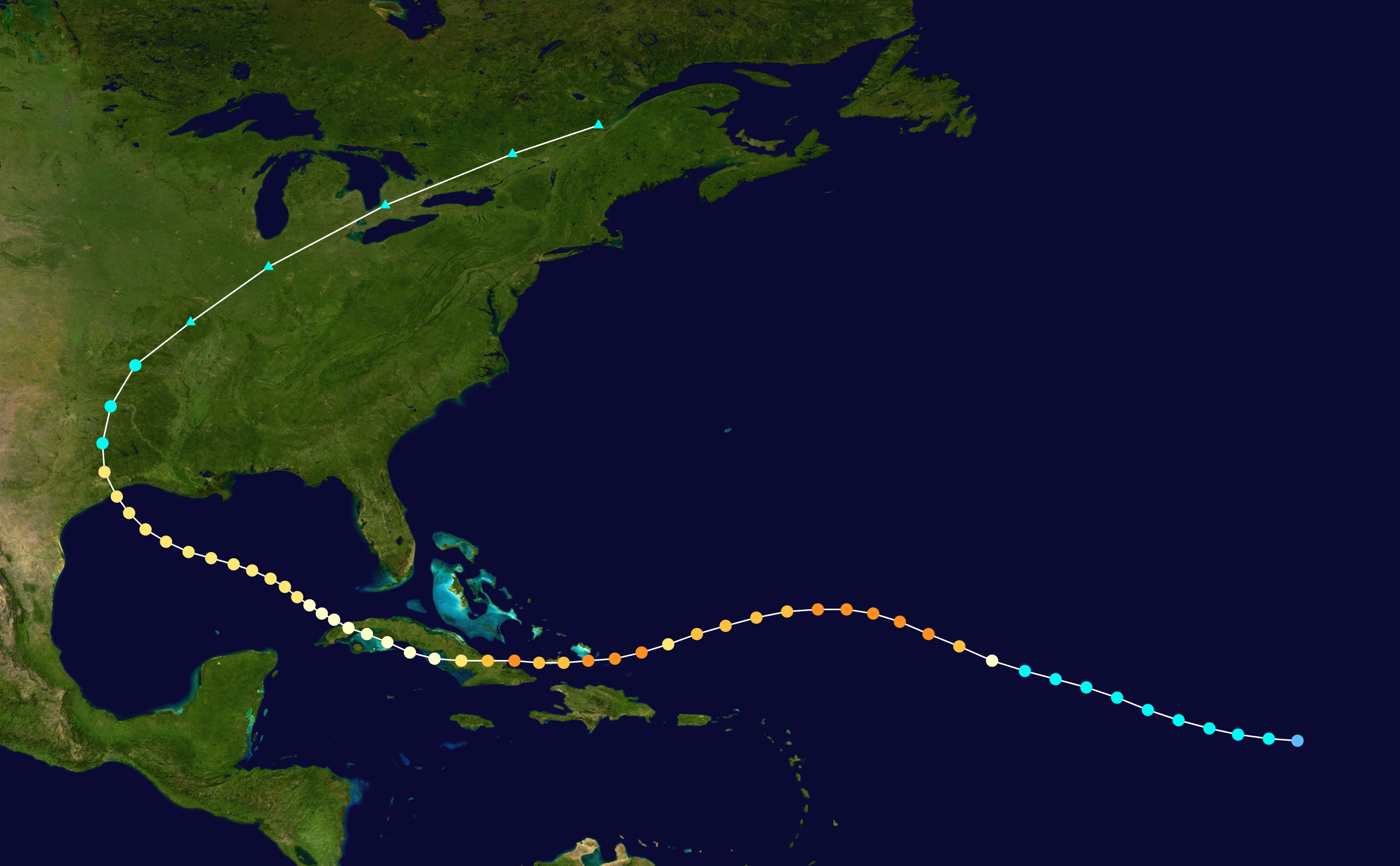
Latest forecast from the NHC has Florence passing 60W south of 30N. I believe a poster (LarryWx?) indicates that doing so implies a greater threat to the ConUS? Anyone have those statistics available?
0 likes
-
Shell Mound
- Category 5
- Posts: 2432
- Age: 33
- Joined: Thu Sep 07, 2017 3:39 pm
- Location: St. Petersburg, FL → Scandinavia
Re: ATL: FLORENCE - Hurricane - Discussion
While I currently expect Florence to curve OTS east of Bermuda, there are some worrying indicators:
*Because Florence has been much more intense than expected, it is certainly farther NE than most of the global models indicated (except the GFS). While this might tend to favour a track OTS, there are some other consequences of this:
**A stronger Florence is a slower Florence. The UKMET and ECMWF have not only been too weak and too far SW with Florence, but also too fast. The GFS has been the slowest and farthest NE, correctly. The last seven runs of the GFS have accurately forecast Florence's intensity and track vs. other models, and worryingly, these last seven runs have shifted Florence farther S by day five (ninety-six hours). That means Florence is going to slow down even more over the next several days. This is bad because:
a) This gives more time for the long-wave trough off the East Coast to miss Florence by days five and six;
b) The TUTT near the Azores retrogrades faster to the SW and is much closer to Florence by then;
c) The feedback -- stronger Florence -> slower Florence -> enhances mid-level shortwave ridging nearby -> misses long-wave trough -> TUTT enhances ridging to the N of the Greater Antilles -> very strong East-Coast ridge extends NE to SW behind long-wave trough -> possibility of Irma- or Ike-like WSW dip for prolonged period of time beyond days five and six
d) If this scenario plays out, it is the second most likely one behind an outright OTS path. IF this happens, then ridging is likely to be sufficiently strong and angled as to drive a very intense Cat-4/5+ Florence WSW, W, and then WNW into FL/eastern Gulf under very favourable outflow conditions (Irma), meaning also lots of ACE build-up and increase in wind field due to some ERCs along the way to FL/Gulf
This looks like all or nothing. If this doesn't curve OTS, we could be looking at something very big and bad for FL and the Gulf.
Oh, and this will likely be a Cat-4 later today...
Here's what I'm referring to:

Andrew (1992)
Ike (2008)
Irma (2017)
*Because Florence has been much more intense than expected, it is certainly farther NE than most of the global models indicated (except the GFS). While this might tend to favour a track OTS, there are some other consequences of this:
**A stronger Florence is a slower Florence. The UKMET and ECMWF have not only been too weak and too far SW with Florence, but also too fast. The GFS has been the slowest and farthest NE, correctly. The last seven runs of the GFS have accurately forecast Florence's intensity and track vs. other models, and worryingly, these last seven runs have shifted Florence farther S by day five (ninety-six hours). That means Florence is going to slow down even more over the next several days. This is bad because:
a) This gives more time for the long-wave trough off the East Coast to miss Florence by days five and six;
b) The TUTT near the Azores retrogrades faster to the SW and is much closer to Florence by then;
c) The feedback -- stronger Florence -> slower Florence -> enhances mid-level shortwave ridging nearby -> misses long-wave trough -> TUTT enhances ridging to the N of the Greater Antilles -> very strong East-Coast ridge extends NE to SW behind long-wave trough -> possibility of Irma- or Ike-like WSW dip for prolonged period of time beyond days five and six
d) If this scenario plays out, it is the second most likely one behind an outright OTS path. IF this happens, then ridging is likely to be sufficiently strong and angled as to drive a very intense Cat-4/5+ Florence WSW, W, and then WNW into FL/eastern Gulf under very favourable outflow conditions (Irma), meaning also lots of ACE build-up and increase in wind field due to some ERCs along the way to FL/Gulf
This looks like all or nothing. If this doesn't curve OTS, we could be looking at something very big and bad for FL and the Gulf.
Oh, and this will likely be a Cat-4 later today...
Here's what I'm referring to:
Andrew (1992)
Ike (2008)
Irma (2017)
Last edited by Shell Mound on Wed Sep 05, 2018 10:29 am, edited 2 times in total.
6 likes
CVW / MiamiensisWx / Shell Mound
The posts in this forum are NOT official forecasts and should not be used as such. They are just the opinion of the poster and may or may not be backed by sound meteorological data. They are NOT endorsed by any professional institution or STORM2K. For official information, please refer to products from the NHC and NWS.
-
Hurricaneman
- Category 5
- Posts: 7404
- Age: 45
- Joined: Tue Aug 31, 2004 3:24 pm
- Location: central florida
Re: ATL: FLORENCE - Hurricane - Discussion
Shell Mound wrote:While I currently expect Florence to curve OTS east of Bermuda, there are some worrying indicators:
*Because Florence has been much more intense than expected, it is certainly farther NE than most of the global models indicated (except the GFS). While this might tend to favour a track OTS, there are some other consequences of this:
**A stronger Florence is a slower Florence. The UKMET and ECMWF have not only been too weak and too far SW with Florence, but also too fast. The GFS has been the slowest and farthest NE, correctly. The last seven runs of the GFS have accurately forecast Florence's intensity and track vs. other models, and worryingly, these last seven runs have shifted Florence farther S by day five (ninety-six hours). That means Florence is going to slow down even more over the next several days. This is bad because:
a) This gives more time for the long-wave trough off the East Coast to miss Florence by days five and six;
b) The TUTT near the Azores retrogrades faster to the SW and is much closer to Florence by then;
c) The feedback -- stronger Florence -> slower Florence -> enhances mid-level shortwave ridging nearby -> misses long-wave trough -> TUTT enhances ridging to the N of the Greater Antilles -> very strong East-Coast ridge extends NE to SW behind long-wave trough -> possibility of Irma- or Ike-like WSW dip for prolonged period of time beyond days five and six
d) If this scenario plays out, it is the second most likely one behind an outright OTS path. IF this happens, then ridging is likely to be sufficiently strong and angled as to drive a very intense Cat-4/5+ Florence WSW, W, and then WNW into FL/eastern Gulf under very favourable outflow conditions (Irma)
This looks like all or nothing. If this doesn't curve OTS, we could be looking at something very big and bad for FL and the Gulf.
Oh, and this will likely be a Cat-4 later today...
Seems close to my idea from last night, this could be out to sea or close to another Andrew 1992, it all depends on the speed of this and how strong the ridge is
0 likes
-
wxman57

- Moderator-Pro Met

- Posts: 23174
- Age: 68
- Joined: Sat Jun 21, 2003 8:06 pm
- Location: Houston, TX (southwest)
Re: ATL: FLORENCE - Hurricane - Discussion
The 10-day EC ensembles from Maue's website tell a different story from the 5-day that Levi posted. True, Florence will have to avoid several opportunities to recurve prior to reaching the East U.S. Coast, but we can't be certain it will recurve east of the U.S. yet. GFS ensembles favor recurve east of the U.S.

3 likes
-
floridasun78
- Category 5
- Posts: 3755
- Joined: Sun May 17, 2009 10:16 pm
- Location: miami fl
Re: ATL: FLORENCE - Hurricane - Discussion
twc saying keep eye on high building and weakness
0 likes
-
cycloneye
- Admin
- Posts: 149467
- Age: 69
- Joined: Thu Oct 10, 2002 10:54 am
- Location: San Juan, Puerto Rico
Re: ATL: FLORENCE - Hurricane - Discussion
Very impressive.

2 likes
Visit the Caribbean-Central America Weather Thread where you can find at first post web cams,radars
and observations from Caribbean basin members Click Here
and observations from Caribbean basin members Click Here
-
Shell Mound
- Category 5
- Posts: 2432
- Age: 33
- Joined: Thu Sep 07, 2017 3:39 pm
- Location: St. Petersburg, FL → Scandinavia
Re: ATL: FLORENCE - Hurricane - Discussion
This is probably close to 120-125 knots now and will be even stronger by this afternoon. No doubt, this is a Cat-4:

It's starting to look startlingly like Irma. Irma actually reached Cat-5 status on this day in 2017.
Expect a special advisory at 2:00 p.m. EDT (18:00 UTC)—and a strong Cat-4 in the books by then.
It's starting to look startlingly like Irma. Irma actually reached Cat-5 status on this day in 2017.
Expect a special advisory at 2:00 p.m. EDT (18:00 UTC)—and a strong Cat-4 in the books by then.
1 likes
CVW / MiamiensisWx / Shell Mound
The posts in this forum are NOT official forecasts and should not be used as such. They are just the opinion of the poster and may or may not be backed by sound meteorological data. They are NOT endorsed by any professional institution or STORM2K. For official information, please refer to products from the NHC and NWS.
-
SconnieCane
- Category 5
- Posts: 1013
- Joined: Thu Aug 02, 2018 5:29 pm
- Location: Madison, WI
Re: ATL: FLORENCE - Hurricane - Discussion
Florence would seem to be flipping the bird to the alleged shear. Storms' habit of doing that this year is why I (and perhaps NHC) overestimated Gordon, while he turned out to struggle at the slightest puff. Is it because it was such a small system compared to Florence (or Lane or Olivia in the EPAC?).
1 likes
-
plasticup
Re: ATL: FLORENCE - Hurricane - Discussion
Regardless of where it ends up, this is the most beautiful storm of the ATL season so far. What a stunner. And tiny, too!


2 likes
-
HurricaneEnzo

- Category 2
- Posts: 743
- Joined: Wed Mar 14, 2018 12:18 pm
- Location: Newport, NC (Hurricane Alley)
Re: ATL: FLORENCE - Hurricane - Discussion
plasticup wrote:Regardless of where it ends up, this is the most beautiful storm of the ATL season so far. What a stunner. And tiny, too!
https://www.tropicaltidbits.com/sat/ima ... ?21.7314.8
https://www.tropicaltidbits.com/sat/ima ... ?21.7314.8
Nice! If someone was to show me those images and say guess how strong it was with no other information I would say 120-125kts.
Obviously you can't go by just these images but Flo is a beauty.
0 likes
Bertha 96' - Fran 96' - Bonnie 98' - Dennis 99' - Floyd 99' - Isabel 03' - Alex 04' - Ophelia 05' - Irene 11' - Arthur 14' - Matthew 16' - Florence 18' - Dorian 19' - Isaias 20' (countless other tropical storms and Hurricane swipes)
I am not a Professional Met just an enthusiast. Get your weather forecasts from the Pros!
I am not a Professional Met just an enthusiast. Get your weather forecasts from the Pros!
-
Shell Mound
- Category 5
- Posts: 2432
- Age: 33
- Joined: Thu Sep 07, 2017 3:39 pm
- Location: St. Petersburg, FL → Scandinavia
Re: ATL: FLORENCE - Hurricane - Discussion
Florence closely resembles Frances (1980), another easterly major hurricane (and probable 125-knot Cat-4, based on satellite, pending reanalysis):
Frances #1
Frances #2
Frances #1
Frances #2
0 likes
CVW / MiamiensisWx / Shell Mound
The posts in this forum are NOT official forecasts and should not be used as such. They are just the opinion of the poster and may or may not be backed by sound meteorological data. They are NOT endorsed by any professional institution or STORM2K. For official information, please refer to products from the NHC and NWS.
-
Cunxi Huang

- Category 1

- Posts: 329
- Age: 27
- Joined: Thu Sep 26, 2013 12:17 pm
- Location: San Jose, CA
- Contact:
Re: ATL: FLORENCE - Hurricane - Discussion
110-115 kt in my opinion.
0 likes
06 SuTY SAOMAI | 09 TY LINFA | 10 TY FANAPI | 10 SuTY MEGI | 16 SuTY MERANTI | 19 SuTY LEKIMA | 24 C2 FRANCINE
DO NOT use my posts for life and death decisions. For official information, please refer to products from your RSMC and national weather agency.
DO NOT use my posts for life and death decisions. For official information, please refer to products from your RSMC and national weather agency.


Re: ATL: FLORENCE - Hurricane - Discussion
Some WMG on BD? I'd be generous and say worthy of 115kts
2 likes
The above post and any post by Ntxw is NOT an official forecast and should not be used as such. It is just the opinion of the poster and may or may not be backed by sound meteorological data. It is NOT endorsed by any professional institution including Storm2k. For official information, please refer to NWS products.
Help support Storm2K!

Who is online
Users browsing this forum: No registered users and 64 guests