WPAC: YUTU - Post-Tropical

Moderator: S2k Moderators

Message
Author
Guamphoon
Tropical Low
Tropical Low
Posts: 32
Joined: Wed Jul 04, 2018 11:57 am
Location: Tamuning, Guam

Re: WPAC: YUTU - Typhoon

#261 Postby Guamphoon » Wed Oct 24, 2018 10:34 am

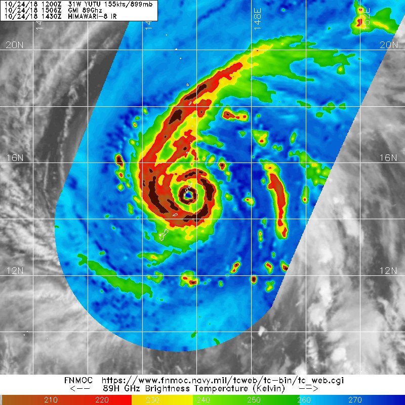
supercane4867 wrote:We have a 155kt TC hitting US territory yet the radar is down. It’s really hard to extrapolate central pressure without sufficient radar data if those stations miss the eye. What a great loss


The Guam radar has been having issues for almost 2 years. It is bullshit that we keep going through this. Somehow the feds can find trillions for corporate tax cuts and the military, but can't get enough money to properly fund NWS radars.

It's a shame.
0 likes   

User avatar
xtyphooncyclonex
Category 5
Category 5
Posts: 3861
Age: 23
Joined: Sat Dec 08, 2012 9:07 am
Location: Cebu City
Contact:

Re: WPAC: YUTU - Typhoon

#262 Postby xtyphooncyclonex » Wed Oct 24, 2018 10:38 am

I've heard some news about Saipan before, but Filipino news barely has any coverage on Yutu passing Saipan. Saipan is a Filipino-plurality territory. Coverage on US media and Filipino media is minimal. This is a devastating, powerful storm and it is unfortunate that there is barely any coverage on Yutu here.
0 likes   
REMINDER: My opinions that I, or any other NON Pro-Met in this forum, are unofficial. Please do not take my opinions as an official forecast and warning. I am NOT a meteorologist. Following my forecasts blindly may lead to false alarm, danger and risk if official forecasts from agencies are ignored.

supercane4867
Category 5
Category 5
Posts: 4966
Joined: Wed Nov 14, 2012 10:43 am

Re: WPAC: YUTU - Typhoon

#263 Postby supercane4867 » Wed Oct 24, 2018 10:39 am

Another northerly wobble. This thing is nuking Tinian and Saipan dead on


Image
Last edited by supercane4867 on Wed Oct 24, 2018 10:39 am, edited 1 time in total.
0 likes   

User avatar
cycloneye
Admin
Admin
Posts: 145296
Age: 68
Joined: Thu Oct 10, 2002 10:54 am
Location: San Juan, Puerto Rico

Re: WPAC: YUTU - Typhoon

#264 Postby cycloneye » Wed Oct 24, 2018 10:39 am

0 likes   
Visit the Caribbean-Central America Weather Thread where you can find at first post web cams,radars
and observations from Caribbean basin members Click Here

supercane4867
Category 5
Category 5
Posts: 4966
Joined: Wed Nov 14, 2012 10:43 am

Re: WPAC: YUTU - Typhoon

#265 Postby supercane4867 » Wed Oct 24, 2018 10:45 am

Saipan beach cam is still on and sounds like total hell on earth. Wish it could survive the storm.

Crazy eyewall lightning going on


https://www.earthcam.com/world/northern ... cam=saipan
0 likes   

User avatar
doomhaMwx
Category 5
Category 5
Posts: 2454
Age: 26
Joined: Tue Apr 18, 2017 4:01 am
Location: Baguio/Benguet, Philippines
Contact:

Re: WPAC: YUTU - Typhoon

#266 Postby doomhaMwx » Wed Oct 24, 2018 10:54 am

Tinian island in the eye of a powerful 155kt Category 5 storm!

Image
Image
3 likes   

edu2703
Category 1
Category 1
Posts: 349
Joined: Thu Aug 23, 2018 7:15 pm

Re: WPAC: YUTU - Typhoon

#267 Postby edu2703 » Wed Oct 24, 2018 10:55 am

Image
0 likes   

User avatar
Hayabusa
Category 5
Category 5
Posts: 4349
Joined: Sun Sep 16, 2018 1:05 pm

Re: WPAC: YUTU - Typhoon

#268 Postby Hayabusa » Wed Oct 24, 2018 10:58 am

FXXT03 EGRR 241556

MET OFFICE TROPICAL CYCLONE GUIDANCE FOR NORTH-WEST PACIFIC

GLOBAL MODEL DATA TIME 12UTC 24.10.2018

TYPHOON YUTU ANALYSED POSITION : 14.7N 146.3E

VERIFYING TIME POSITION STRENGTH TENDENCY
-------------- -------- -------- --------
12UTC 24.10.2018 14.7N 146.3E INTENSE
00UTC 25.10.2018 15.8N 144.5E INTENSE LITTLE CHANGE
12UTC 25.10.2018 16.6N 142.8E INTENSE INTENSIFYING RAPIDLY
00UTC 26.10.2018 16.9N 140.9E INTENSE INTENSIFYING SLIGHTLY
12UTC 26.10.2018 17.5N 138.5E INTENSE WEAKENING SLIGHTLY
00UTC 27.10.2018 18.1N 135.5E INTENSE INTENSIFYING SLIGHTLY
12UTC 27.10.2018 18.2N 132.7E INTENSE WEAKENING SLIGHTLY
00UTC 28.10.2018 17.5N 130.3E INTENSE INTENSIFYING SLIGHTLY
12UTC 28.10.2018 16.7N 128.4E INTENSE LITTLE CHANGE
00UTC 29.10.2018 16.1N 126.6E INTENSE LITTLE CHANGE
12UTC 29.10.2018 15.6N 124.8E INTENSE WEAKENING SLIGHTLY
00UTC 30.10.2018 15.6N 122.6E INTENSE WEAKENING SLIGHTLY
12UTC 30.10.2018 15.7N 120.0E MODERATE WEAKENING RAPIDLY
0 likes   
ヤンデレ女が寝取られるているのを見たい!!!
ECMWF ensemble NWPAC plots: https://ecmwfensnwpac.imgbb.com/
Multimodel NWPAC plots: https://multimodelnwpac.imgbb.com/
GFS Ensemble NWPAC plots (16 & 35 day forecast): https://gefsnwpac.imgbb.com/
Plots updated automatically

supercane4867
Category 5
Category 5
Posts: 4966
Joined: Wed Nov 14, 2012 10:43 am

Re: WPAC: YUTU - Typhoon

#269 Postby supercane4867 » Wed Oct 24, 2018 11:03 am

Image
0 likes   

edu2703
Category 1
Category 1
Posts: 349
Joined: Thu Aug 23, 2018 7:15 pm

Re: WPAC: YUTU - Typhoon

#270 Postby edu2703 » Wed Oct 24, 2018 11:05 am

0 likes   

User avatar
Hayabusa
Category 5
Category 5
Posts: 4349
Joined: Sun Sep 16, 2018 1:05 pm

Re: WPAC: YUTU - Typhoon

#271 Postby Hayabusa » Wed Oct 24, 2018 11:15 am

2018OCT24 154000 0.0 0.0 0.0 0.0 0.0 0.0 N/A N/A N/A OFF 99.50 99.50 LAND N/A N/A 15.04 -145.63 ARCHER HIM-8 18.5
0 likes   
ヤンデレ女が寝取られるているのを見たい!!!
ECMWF ensemble NWPAC plots: https://ecmwfensnwpac.imgbb.com/
Multimodel NWPAC plots: https://multimodelnwpac.imgbb.com/
GFS Ensemble NWPAC plots (16 & 35 day forecast): https://gefsnwpac.imgbb.com/
Plots updated automatically

CrazyC83
Professional-Met
Professional-Met
Posts: 34002
Joined: Tue Mar 07, 2006 11:57 pm
Location: Deep South, for the first time!

Re: WPAC: YUTU - Typhoon

#272 Postby CrazyC83 » Wed Oct 24, 2018 11:16 am

It's going to be one epic disaster there. Making even Michael look weak by comparison.
0 likes   

SconnieCane
Category 4
Category 4
Posts: 998
Joined: Thu Aug 02, 2018 5:29 pm
Location: Madison, WI

Re: WPAC: YUTU - Typhoon

#273 Postby SconnieCane » Wed Oct 24, 2018 11:47 am

We've discussed the rarity of both North Pacific basins plus the North Atlantic having above-average ACE, but how about each of them getting a major TC landfall in the span of two weeks? :eek:

Andrew/Iniki/Omar in '92 might be the last time something similar has occurred.
2 likes   

CrazyC83
Professional-Met
Professional-Met
Posts: 34002
Joined: Tue Mar 07, 2006 11:57 pm
Location: Deep South, for the first time!

Re: WPAC: YUTU - Typhoon

#274 Postby CrazyC83 » Wed Oct 24, 2018 12:44 pm

SconnieCane wrote:We've discussed the rarity of both North Pacific basins plus the North Atlantic having above-average ACE, but how about each of them getting a major TC landfall in the span of two weeks? :eek:

Andrew/Iniki/Omar in '92 might be the last time something similar has occurred.


Only thing missing is a major hit from a monster in the Indian Ocean. We're into their 2nd season now.
0 likes   

User avatar
WAcyclone
Category 1
Category 1
Posts: 352
Joined: Sat Jul 01, 2017 1:56 pm
Location: Perth, Western Australia

Re: WPAC: YUTU - Typhoon

#275 Postby WAcyclone » Wed Oct 24, 2018 12:48 pm

It indeed doesn't look like any part of Saipan went through the eye. IR imagery can be deceiving...

 https://twitter.com/UWCIMSS/status/1055153105623506944


Image

Image
2 likes   

User avatar
Hayabusa
Category 5
Category 5
Posts: 4349
Joined: Sun Sep 16, 2018 1:05 pm

Re: WPAC: YUTU - Typhoon

#276 Postby Hayabusa » Wed Oct 24, 2018 12:55 pm

HWRF 12z initialized Yutu at 158.5 knots
0 likes   
ヤンデレ女が寝取られるているのを見たい!!!
ECMWF ensemble NWPAC plots: https://ecmwfensnwpac.imgbb.com/
Multimodel NWPAC plots: https://multimodelnwpac.imgbb.com/
GFS Ensemble NWPAC plots (16 & 35 day forecast): https://gefsnwpac.imgbb.com/
Plots updated automatically

User avatar
Cunxi Huang
Category 1
Category 1
Posts: 329
Age: 27
Joined: Thu Sep 26, 2013 12:17 pm
Location: San Jose, CA
Contact:

Re: WPAC: YUTU - Typhoon

#277 Postby Cunxi Huang » Wed Oct 24, 2018 1:15 pm

Super Typhoon Meranti over Itbayat:
Image

Super Typhoon Yutu over Tinian:
Image
5 likes   
06 SuTY SAOMAI | 09 TY LINFA | 10 TY FANAPI | 10 SuTY MEGI | 16 SuTY MERANTI | 19 SuTY LEKIMA | 24 C2 FRANCINE
DO NOT use my posts for life and death decisions. For official information, please refer to products from your RSMC and national weather agency.

User avatar
Hayabusa
Category 5
Category 5
Posts: 4349
Joined: Sun Sep 16, 2018 1:05 pm

Re: WPAC: YUTU - Typhoon

#278 Postby Hayabusa » Wed Oct 24, 2018 1:24 pm

TPPN10 PGTW 241810

A. SUPER TYPHOON 31W (YUTU)

B. 24/1740Z

C. 15.28N

D. 145.33E

E. ONE/HMWRI8

F. T7.0/7.5/D1.0/24HRS STT: W0.5/03HRS

G. IR/EIR

H. REMARKS: 01A/PBO EYE/ANMTN. WMG EYE SURROUNDED BY W YIELDS
AN E# OF 6.0. ADDED 1.0 EYE ADJUSTMENT FOR W, TO YIELD A DT OF
7.0. MET AND PT AGREE. DBO DT.

I. ADDITIONAL POSITIONS:
24/1506Z 14.90N 145.75E GPMI
24/1551Z 15.05N 145.68E ATMS


LOWE
0 likes   
ヤンデレ女が寝取られるているのを見たい!!!
ECMWF ensemble NWPAC plots: https://ecmwfensnwpac.imgbb.com/
Multimodel NWPAC plots: https://multimodelnwpac.imgbb.com/
GFS Ensemble NWPAC plots (16 & 35 day forecast): https://gefsnwpac.imgbb.com/
Plots updated automatically

User avatar
Hayabusa
Category 5
Category 5
Posts: 4349
Joined: Sun Sep 16, 2018 1:05 pm

Re: WPAC: YUTU - Typhoon

#279 Postby Hayabusa » Wed Oct 24, 2018 1:34 pm

The passage over the island seems to have weakened Yutu as shown on BD imagery
0 likes   
ヤンデレ女が寝取られるているのを見たい!!!
ECMWF ensemble NWPAC plots: https://ecmwfensnwpac.imgbb.com/
Multimodel NWPAC plots: https://multimodelnwpac.imgbb.com/
GFS Ensemble NWPAC plots (16 & 35 day forecast): https://gefsnwpac.imgbb.com/
Plots updated automatically

User avatar
TorSkk
Category 2
Category 2
Posts: 514
Joined: Thu Jul 05, 2018 5:08 am

Re: WPAC: YUTU - Typhoon

#280 Postby TorSkk » Wed Oct 24, 2018 1:35 pm

More likely the ongoing ERC has weakened it.
1 likes   


Return to “2018”

Who is online

Users browsing this forum: No registered users and 3 guests