ATL: FLORENCE - Models

Moderator: S2k Moderators

Message
Author
User avatar
Hammy
Category 5
Category 5
Posts: 5849
Age: 41
Joined: Fri May 25, 2012 5:25 pm
Contact:

Re: ATL: FLORENCE - Models

#3041 Postby Hammy » Sun Sep 09, 2018 5:12 pm

Aric Dunn wrote:Maybe its the start of (logical ) shift back west for the models. :P lol


Or the GFS finally figuring out what the other models knew already.
2 likes   
The above post is not official and should not be used as such. It is the opinion of the poster and may or may not be backed by sound meteorological data. It is not endorsed by any professional institution or storm2k.org. For official information, please refer to the NHC and NWS products.

supercane4867
Category 5
Category 5
Posts: 4966
Joined: Wed Nov 14, 2012 10:43 am

Re: ATL: FLORENCE - Models

#3042 Postby supercane4867 » Sun Sep 09, 2018 5:12 pm

Once again the NHC is smart enough to not buy the GFS solutions earlier
3 likes   

plasticup

Re: ATL: FLORENCE - Models

#3043 Postby plasticup » Sun Sep 09, 2018 5:20 pm

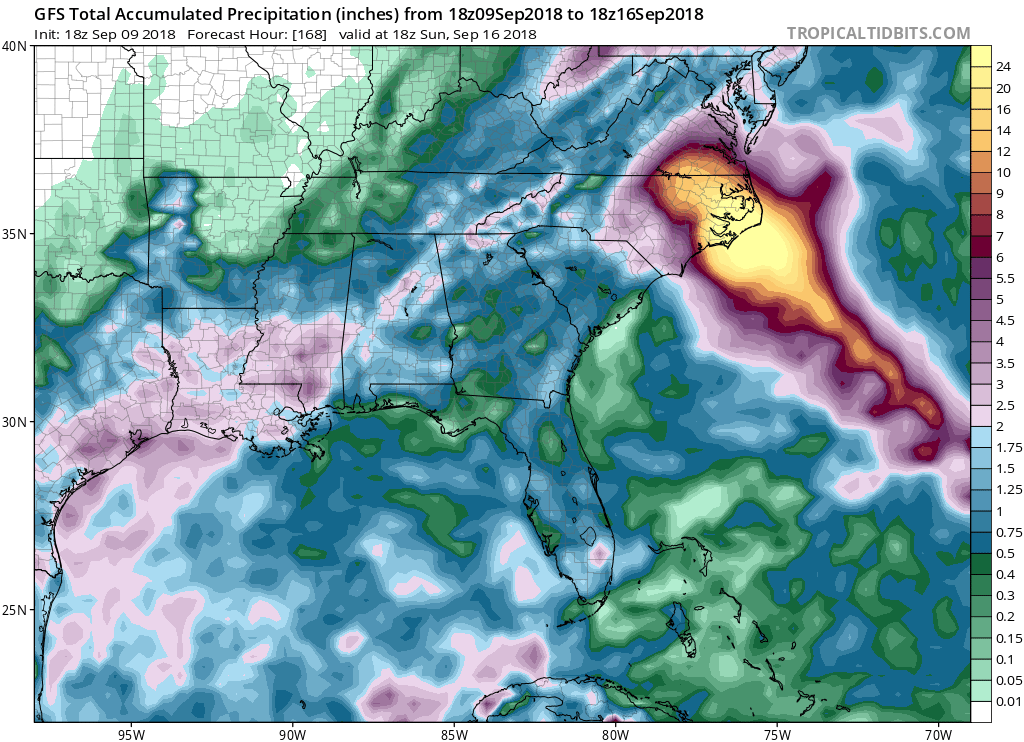
tolakram wrote:18Z GFS
[im g]https://i.imgur.com/jmVDjqG.gif[/img]

The stall will be as bad as the landfall. Eastern NC handles flooding so poorly. Some schools are still closed from Matthew 2016.
0 likes   

User avatar
ronjon
Category 5
Category 5
Posts: 4822
Joined: Fri Aug 19, 2005 5:17 pm
Location: Hernando Beach, FL

Re: ATL: FLORENCE - Models

#3044 Postby ronjon » Sun Sep 09, 2018 5:21 pm

I think if there are any future shifts to the track, it'll likely be southward into SC - although not expecting huge swings. The mean tracks of the GEM, ECM, and UKMET ensemble runs are into northern SC.
3 likes   

User avatar
gatorcane
S2K Supporter
S2K Supporter
Posts: 23691
Age: 47
Joined: Sun Mar 13, 2005 3:54 pm
Location: Boca Raton, FL

Re: ATL: FLORENCE - Models

#3045 Postby gatorcane » Sun Sep 09, 2018 5:22 pm

Wow :eek: :double:
There is not even a color code for the rainfall totals.
Image
0 likes   

supercane4867
Category 5
Category 5
Posts: 4966
Joined: Wed Nov 14, 2012 10:43 am

Re: ATL: FLORENCE - Models

#3046 Postby supercane4867 » Sun Sep 09, 2018 5:23 pm

18z GFS has Flo not moving an inch after landfall. It just sitting over the coast for days
0 likes   

Raebie
Category 3
Category 3
Posts: 822
Joined: Fri Sep 12, 2003 8:00 pm
Location: Charlotte, NC

Re: ATL: FLORENCE - Models

#3047 Postby Raebie » Sun Sep 09, 2018 5:23 pm

gatorcane wrote:Wow :eek: :double:
There is not even a color code for the rainfall totals.


On top of surge flooding. Any projections on that yet?
0 likes   

plasticup

Re: ATL: FLORENCE - Models

#3048 Postby plasticup » Sun Sep 09, 2018 5:24 pm

gatorcane wrote:Wow :eek: :double:
There is not even a color code for the rainfall totals.
Image

26 inches of rain in some of the poorest counties in the country. These are counties where schools are still closed from the flooding of Mathew in 2016.
0 likes   

supercane4867
Category 5
Category 5
Posts: 4966
Joined: Wed Nov 14, 2012 10:43 am

Re: ATL: FLORENCE - Models

#3049 Postby supercane4867 » Sun Sep 09, 2018 5:25 pm

At 180hr it’s drifting due S back offshore LOL
0 likes   

Raebie
Category 3
Category 3
Posts: 822
Joined: Fri Sep 12, 2003 8:00 pm
Location: Charlotte, NC

Re: ATL: FLORENCE - Models

#3050 Postby Raebie » Sun Sep 09, 2018 5:27 pm

supercane4867 wrote:At 180hr it’s drifting due S back offshore LOL


The GFS is determined to kill NC dead.
0 likes   

User avatar
meriland29
Category 2
Category 2
Posts: 770
Joined: Thu Aug 03, 2017 11:05 am

Re: ATL: FLORENCE - Models

#3051 Postby meriland29 » Sun Sep 09, 2018 5:28 pm

Quoted from NHCs latest discussion:

The GFS and its ensemble mean
are outliers from the main model envelope, showing the system near
the Outer Banks, while the rest of the guidance is well to the
southwest. While a near-miss isn't impossible given the spread of
the ECMWF Ensemble, there is much more support for a track to the
southwest, especially considering the poleward bias of the GFS thus
far this season. Therefore, the official track forecast is shifted a
little bit to the southwest, and is very close to the
corrected-consensus models.


You really have to appreciate the elaborate explanation as to why they are not giving into the outlier GFS models as of recently (minus the 18z)
1 likes   

User avatar
toad strangler
S2K Supporter
S2K Supporter
Posts: 4543
Joined: Sun Jul 28, 2013 3:09 pm
Location: Earth
Contact:

Re: ATL: FLORENCE - Models

#3052 Postby toad strangler » Sun Sep 09, 2018 5:28 pm

plasticup wrote:
gatorcane wrote:Wow :eek: :double:
There is not even a color code for the rainfall totals.

26 inches of rain in some of the poorest counties in the country. These are counties where schools are still closed from the flooding of Mathew in 2016.


They should probably move inland
0 likes   

seahawkjd
S2K Supporter
S2K Supporter
Posts: 632
Joined: Wed Sep 10, 2003 4:12 pm
Location: Morehead City, NC
Contact:

Re: ATL: FLORENCE - Models

#3053 Postby seahawkjd » Sun Sep 09, 2018 5:28 pm

plasticup wrote:
gatorcane wrote:Wow :eek: :double:
There is not even a color code for the rainfall totals.

26 inches of rain in some of the poorest counties in the country. These are counties where schools are still closed from the flooding of Mathew in 2016.


Living in the area you are talking about; I have to ask what counties are you referring to that haven't reopened schools after 2 years?
0 likes   
Gloria, Hugo, Emily, Bertha, Bonnie, Dennis (twice), Fran, Floyd, Isabel, Irene, Arthur, Matthew, Florence, Dorian (and many tropical storms and nor'easters).

User avatar
Nimbus
Category 5
Category 5
Posts: 5302
Joined: Mon Jul 19, 2004 10:54 am

Re: ATL: FLORENCE - Models

#3054 Postby Nimbus » Sun Sep 09, 2018 5:29 pm

The target has been North Carolina for a while now, a 922 MB supercane lingering just offshore for days isn't any better from a disaster relief standpoint. Most local governments are geared to the 72 hour cone and warnings since that needs to be choreographed efficiently. Potentially less than two days away from that decision point. 18z GFS run had some MB forecasts in the 930's 12Z HWRF about 950 mb..
0 likes   

User avatar
Blown Away
S2K Supporter
S2K Supporter
Posts: 10147
Joined: Wed May 26, 2004 6:17 am

Re: ATL: FLORENCE - Models

#3055 Postby Blown Away » Sun Sep 09, 2018 5:32 pm

GFS seeing stronger ridging on 18z... 00z should be interesting, maybe the trend is south? It can't be slam dunk when the system is only @57W...
1 likes   
Hurricane Eye Experience: David 79, Irene 99, Frances 04, Jeanne 04, Wilma 05... EYE COMING MY WAY IN 2024…
Hurricane Brush Experience: Andrew 92, Erin 95, Floyd 99, Matthew 16, Irma 17, Ian 22, Nicole 22…

User avatar
MississippiWx
S2K Supporter
S2K Supporter
Posts: 1699
Joined: Sat Aug 14, 2010 1:44 pm
Location: Hattiesburg, Mississippi

Re: ATL: FLORENCE - Models

#3056 Postby MississippiWx » Sun Sep 09, 2018 5:36 pm

The stalling showed by the GFS is not laughable. It’s very realistic with very weak steering and no where to go.
1 likes   
This post is not an official forecast and should not be used as such. It is just the opinion of MississippiWx and may or may not be backed by sound meteorological data. It is not endorsed by any professional institution including storm2k.org. For Official Information please refer to the NHC and NWS products.

b0tzy29
Tropical Depression
Tropical Depression
Posts: 65
Joined: Sun Sep 02, 2018 9:03 am

Re: ATL: FLORENCE - Models

#3057 Postby b0tzy29 » Sun Sep 09, 2018 5:40 pm

Image

Does this imply the center will be over the coast line from hour 102 - 192 of the forecast. That would be 90 hours or almost 4 days. That would be absolutely devastating if it actually did that.
0 likes   

User avatar
Blinhart
Category 5
Category 5
Posts: 2081
Age: 48
Joined: Thu Sep 08, 2011 3:13 pm
Location: Crowley, La.

Re: ATL: FLORENCE - Models

#3058 Postby Blinhart » Sun Sep 09, 2018 5:44 pm

b0tzy29 wrote:Image

Does this imply the center will be over the coast line from hour 102 - 192 of the forecast. That would be 90 hours or almost 4 days. That would be absolutely devastating if it actually did that.


Just ask Texas about that how bad it would be.
0 likes   
Personal Forecast Disclaimer:
The posts in this forum are NOT official forecast and should not be used as such. They are just the opinion of the poster and may or may not be backed by sound meteorological data. They are NOT endorsed by any professional institution or storm2k.org. For official information, please refer to the NHC and NWS products.

BobHarlem
Category 5
Category 5
Posts: 2111
Joined: Thu Oct 20, 2005 6:11 pm

Re: ATL: FLORENCE - Models

#3059 Postby BobHarlem » Sun Sep 09, 2018 5:48 pm

18Z GFS goes back and hits Bermuda?
1 likes   

PandaCitrus
Category 1
Category 1
Posts: 424
Joined: Mon Sep 04, 2017 2:44 pm

Re: ATL: FLORENCE - Models

#3060 Postby PandaCitrus » Sun Sep 09, 2018 5:50 pm

What would the storm surge forecast be for a stalled out storm for 90 hours? SLOSH models have potential for up to 28 feet at high tide in parts of coastal North Carolina in a Cat 4.
Last edited by PandaCitrus on Sun Sep 09, 2018 5:51 pm, edited 1 time in total.
0 likes   


Return to “2018”

Who is online

Users browsing this forum: No registered users and 6 guests