I guess they should have waited for more recon data..
150600 1124N 05257W 8433 01561 0119 +163 +163 178046 049 051 077 03
150630 1126N 05257W 8419 01577 0115 +170 +170 167041 045 061 086 00
150700 1128N 05257W 8421 01572 0116 +171 +171 169031 046 065 073 00
150730 1130N 05258W 8433 01565 0114 +176 +176 162043 047 056 065 00
150800 1132N 05258W 8427 01571 0122 +166 +166 147053 055 048 031 00
150830 1134N 05258W 8431 01567 0124 +163 +163 150049 054 043 031 00
150900 1136N 05258W 8434 01570 0120 +160 +160 152040 049 043 021 00
55 fl and 65kt SFMR in the se quad still. NE might be even higher..
ATL: KIRK - Remnants - Discussion
Moderator: S2k Moderators
-
Aric Dunn
- Category 5

- Posts: 21238
- Age: 43
- Joined: Sun Sep 19, 2004 9:58 pm
- Location: Ready for the Chase.
- Contact:
Re: ATL: KIRK - Tropical Storm - Discussion
1 likes
Note: If I make a post that is brief. Please refer back to previous posts for the analysis or reasoning. I do not re-write/qoute what my initial post said each time.
If there is nothing before... then just ask
Space & Atmospheric Physicist, Embry-Riddle Aeronautical University,
I believe the sky is falling...
If there is nothing before... then just ask
Space & Atmospheric Physicist, Embry-Riddle Aeronautical University,
I believe the sky is falling...
-
brohavwx
- Tropical Depression

- Posts: 74
- Age: 64
- Joined: Thu Jun 21, 2018 7:16 pm
- Location: Barbados
- Contact:
Re: ATL: KIRK - Tropical Storm - Discussion
Aric Dunn wrote:I guess they should have waited for more recon data..
150600 1124N 05257W 8433 01561 0119 +163 +163 178046 049 051 077 03
150630 1126N 05257W 8419 01577 0115 +170 +170 167041 045 061 086 00
150700 1128N 05257W 8421 01572 0116 +171 +171 169031 046 065 073 00
150730 1130N 05258W 8433 01565 0114 +176 +176 162043 047 056 065 00
150800 1132N 05258W 8427 01571 0122 +166 +166 147053 055 048 031 00
150830 1134N 05258W 8431 01567 0124 +163 +163 150049 054 043 031 00
150900 1136N 05258W 8434 01570 0120 +160 +160 152040 049 043 021 00
55 fl and 65kt SFMR in the se quad still. NE might be even higher..
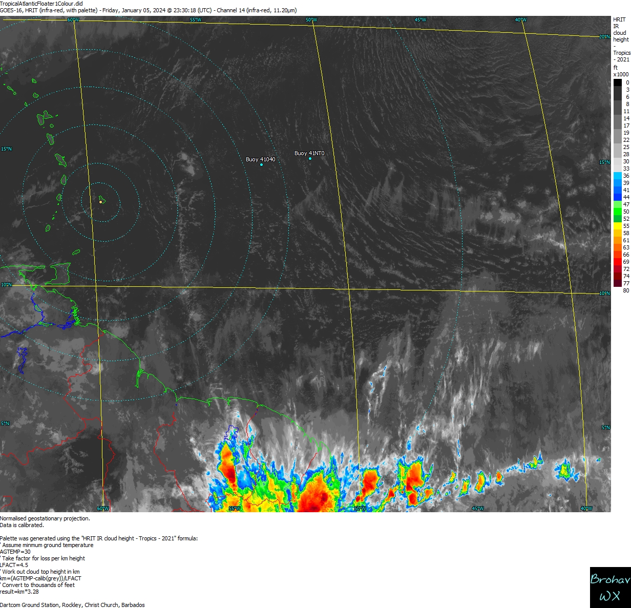
We're watching here in Barbados and we wondering if we might get a borderline Cat 1 or at least gusts in that ballpark even with it passing north of us.
0 likes
-
Aric Dunn
- Category 5
- Posts: 21238
- Age: 43
- Joined: Sun Sep 19, 2004 9:58 pm
- Location: Ready for the Chase.
- Contact:
Re: ATL: KIRK - Tropical Storm - Discussion
brohavwx wrote:Odd, stony silence here now though. Hmm.
yeah it is weird. though maybe everyone was thinking it is likely already dead from shear.
1 likes
Note: If I make a post that is brief. Please refer back to previous posts for the analysis or reasoning. I do not re-write/qoute what my initial post said each time.
If there is nothing before... then just ask
Space & Atmospheric Physicist, Embry-Riddle Aeronautical University,
I believe the sky is falling...
If there is nothing before... then just ask
Space & Atmospheric Physicist, Embry-Riddle Aeronautical University,
I believe the sky is falling...
Re: ATL: KIRK - Tropical Storm - Discussion
Aric Dunn wrote:I guess they should have waited for more recon data..
150600 1124N 05257W 8433 01561 0119 +163 +163 178046 049 051 077 03
150630 1126N 05257W 8419 01577 0115 +170 +170 167041 045 061 086 00
150700 1128N 05257W 8421 01572 0116 +171 +171 169031 046 065 073 00
150730 1130N 05258W 8433 01565 0114 +176 +176 162043 047 056 065 00
150800 1132N 05258W 8427 01571 0122 +166 +166 147053 055 048 031 00
150830 1134N 05258W 8431 01567 0124 +163 +163 150049 054 043 031 00
150900 1136N 05258W 8434 01570 0120 +160 +160 152040 049 043 021 00
55 fl and 65kt SFMR in the se quad still. NE might be even higher..
From someone at another BB, those highest surface winds in SE sector are likely in a thunderstorm band being that there are high rain rates and lower FL winds above those highest surface winds.
Last edited by LarryWx on Wed Sep 26, 2018 10:40 am, edited 1 time in total.
0 likes
Personal Forecast Disclaimer:
The posts in this forum are NOT official forecasts and should not be used as such. They are just the opinion of the poster and may or may not be backed by sound meteorological data. They are NOT endorsed by any professional institution or storm2k.org. For official information, please refer to the NHC and NWS products.
The posts in this forum are NOT official forecasts and should not be used as such. They are just the opinion of the poster and may or may not be backed by sound meteorological data. They are NOT endorsed by any professional institution or storm2k.org. For official information, please refer to the NHC and NWS products.

Re: ATL: KIRK - Tropical Storm - Discussion
It should be dead after tomorrow with the wall of shear.Good look in Barbados and other islands down there.
1 likes
-
txwatcher91
- Category 5
- Posts: 1498
- Joined: Tue Aug 02, 2005 2:29 pm
Re: ATL: KIRK - Tropical Storm - Discussion
Other than the erroneous thunderstorm recon went through, so far everything supports a 40kt TS based on SFMR.
0 likes
-
Dean4Storms
- S2K Supporter

- Posts: 6358
- Age: 63
- Joined: Sun Aug 31, 2003 1:01 pm
- Location: Miramar Bch. FL
-
moja.ram
Re: ATL: KIRK - Tropical Storm - Discussion
boca wrote:It should be dead after tomorrow with the wall of shear.Good look in Barbados and other islands down there.
What do you mean dead? like to a depression or completely out cold?
0 likes

Re: ATL: KIRK - Tropical Storm - Discussion
Wow, that is about the highest rain rate I have seen in the last couple years.
86 mm/hr in the clear

86 mm/hr in the clear
0 likes
-
brohavwx
- Tropical Depression
- Posts: 74
- Age: 64
- Joined: Thu Jun 21, 2018 7:16 pm
- Location: Barbados
- Contact:
Re: ATL: KIRK - Tropical Storm - Discussion
LarryWx wrote:Aric Dunn wrote:I guess they should have waited for more recon data..
150600 1124N 05257W 8433 01561 0119 +163 +163 178046 049 051 077 03
150630 1126N 05257W 8419 01577 0115 +170 +170 167041 045 061 086 00
150700 1128N 05257W 8421 01572 0116 +171 +171 169031 046 065 073 00
150730 1130N 05258W 8433 01565 0114 +176 +176 162043 047 056 065 00
150800 1132N 05258W 8427 01571 0122 +166 +166 147053 055 048 031 00
150830 1134N 05258W 8431 01567 0124 +163 +163 150049 054 043 031 00
150900 1136N 05258W 8434 01570 0120 +160 +160 152040 049 043 021 00
55 fl and 65kt SFMR in the se quad still. NE might be even higher..
From someone at another BB, those highest surface winds in SE sector are likely in a thunderstorm band being that there are high rain rates and lower FL winds above those highest surface winds.
I don't see much thunderstorm evidence all down by 10-11N, but even its was or does happen as it passes us, tail band activity has been known to cause some damage and sometimes after people have ventured out thinking all has passed ... we had a blast of high winds around 10 PM 'after' Tomas has passed us at 7 AM ... thankfully it was at night as I saw a galvanized sheet flung a short distance that could have sent a person in its the way to the casualty or the morgue.
0 likes
-
Aric Dunn
- Category 5
- Posts: 21238
- Age: 43
- Joined: Sun Sep 19, 2004 9:58 pm
- Location: Ready for the Chase.
- Contact:
Re: ATL: KIRK - Tropical Storm - Discussion
so far with this set.. 60mph is very reasonable. though next set should see the center pass and possibly slightly stronger winds.
154300 1258N 05339W 8429 01550 0076 +164 +157 134058 060 042 001 00
154330 1256N 05341W 8432 01545 0072 +167 +157 134060 061 046 001 00
154400 1255N 05342W 8429 01547 0069 +170 +156 132058 059 048 000 00
154430 1254N 05343W 8429 01545 0065 +173 +153 133057 059 047 000 00
154500 1253N 05344W 8429 01543 0062 +177 +139 137054 056 048 002 00
154530 1252N 05345W 8433 01538 0057 +181 +139 137053 054 048 001 00
154600 1251N 05346W 8429 01540 0059 +178 +141 136050 053 047 005 00
154630 1250N 05347W 8432 01537 0060 +174 +152 139053 054 048 005 00
154700 1249N 05349W 8433 01536 0058 +172 +162 137055 055 050 005 00
154730 1247N 05350W 8432 01537 0054 +179 +159 133052 055 050 006 00
154800 1246N 05351W 8429 01537 0054 +176 +160 139048 051 049 007 00
154830 1245N 05352W 8432 01534 0056 +172 +158 139044 046 049 009 00
154900 1244N 05353W 8425 01542 0057 +171 +151 135046 049 052 007 0
0 likes
Note: If I make a post that is brief. Please refer back to previous posts for the analysis or reasoning. I do not re-write/qoute what my initial post said each time.
If there is nothing before... then just ask
Space & Atmospheric Physicist, Embry-Riddle Aeronautical University,
I believe the sky is falling...
If there is nothing before... then just ask
Space & Atmospheric Physicist, Embry-Riddle Aeronautical University,
I believe the sky is falling...
-
brohavwx
- Tropical Depression
- Posts: 74
- Age: 64
- Joined: Thu Jun 21, 2018 7:16 pm
- Location: Barbados
- Contact:
Re: ATL: KIRK - Tropical Storm - Discussion
GCANE wrote:Wow, that is about the highest rain rate I have seen in the last couple years.
86 mm/hr in the clear
A few days ago when we were monitoring the Precipitation forecast models (on Tidbits) we saw high rainfall in it for us here in Barbados, but that diminished with everything else, maybe that may be coming to be now. Again, we'll see.
0 likes
-
Aric Dunn
- Category 5
- Posts: 21238
- Age: 43
- Joined: Sun Sep 19, 2004 9:58 pm
- Location: Ready for the Chase.
- Contact:
Re: ATL: KIRK - Tropical Storm - Discussion
So yeah 65 seems reasonable a few flagged sfmr and FL but plenty supporting 65 to 70 mph.
but 65 looks like the right adjustment.
155030 1241N 05357W 8422 01538 0046 +181 +166 136052 055 065 017 03
155100 1240N 05358W 8430 01538 0072 +164 +164 137056 058 065 019 00
155130 1239N 05359W 8429 01528 0067 +167 +167 144058 061 059 014 03
155200 1237N 05400W 8428 01529 0064 +164 +164 148054 056 060 011 00
155230 1236N 05401W 8416 01540 0053 +165 +165 150056 056 060 011 00
155300 1235N 05402W 8435 01514 0054 +169 +168 151056 058 059 009 00
0 likes
Note: If I make a post that is brief. Please refer back to previous posts for the analysis or reasoning. I do not re-write/qoute what my initial post said each time.
If there is nothing before... then just ask
Space & Atmospheric Physicist, Embry-Riddle Aeronautical University,
I believe the sky is falling...
If there is nothing before... then just ask
Space & Atmospheric Physicist, Embry-Riddle Aeronautical University,
I believe the sky is falling...
-
Aric Dunn
- Category 5
- Posts: 21238
- Age: 43
- Joined: Sun Sep 19, 2004 9:58 pm
- Location: Ready for the Chase.
- Contact:
Re: ATL: KIRK - Tropical Storm - Discussion
Also looks like the center has been pulled north into the convection per recon.. and or being pulled.
1 likes
Note: If I make a post that is brief. Please refer back to previous posts for the analysis or reasoning. I do not re-write/qoute what my initial post said each time.
If there is nothing before... then just ask
Space & Atmospheric Physicist, Embry-Riddle Aeronautical University,
I believe the sky is falling...
If there is nothing before... then just ask
Space & Atmospheric Physicist, Embry-Riddle Aeronautical University,
I believe the sky is falling...
Re: ATL: KIRK - Tropical Storm - Discussion
With the milestone rain rate, IR presentation, and layering cirrus; no doubt that was a huge vortical hot tower.
Judging by Recon's pressure drop, likely this is RI.
Judging by Recon's pressure drop, likely this is RI.
1 likes
Re: ATL: KIRK - Tropical Storm - Discussion
That 65-knot SFMR was in a moderate rain-rate cell (about 15 to 20 mm/hr).
0 likes
-
meriland29

- Category 2

- Posts: 770
- Joined: Thu Aug 03, 2017 11:05 am
Re: ATL: KIRK - Tropical Storm - Discussion
If the system ends up a lot stronger before it hits that sheer... What that likely mean that the storm would not be able to weaken all the way down to a tropical low / wave?
0 likes
Re: ATL: KIRK - Tropical Storm - Discussion
I like the high OHC water in about 100 hrs.
Classic West-Carib spin-up fuel.

Classic West-Carib spin-up fuel.
0 likes
Who is online
Users browsing this forum: No registered users and 48 guests