ATL: ALBERTO - Post-Tropical
Moderator: S2k Moderators


Re: ATL: INVEST 90L - Discussion
AdamFirst wrote:boca wrote:Even if I lose the bet it’s beer so to me it’s all good.
Might as well knock back some cold ones as we're rained in
Burgers on a stovetop or griddle can be just as good as they are off a grill
Maybe go to your closest VA Cemetary and pay homage to those whom we honor for Memorial Day.
I am sure they dont mind a good brew or two and some good chow in honor of them prior to their day.

5 likes
-
northjaxpro

- S2K Supporter

- Posts: 8900
- Joined: Mon Sep 27, 2010 11:21 am
- Location: Jacksonville, FL
Re: ATL: INVEST 90L - Models
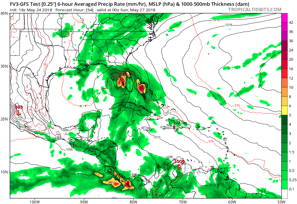
Evil Jeremy wrote:gatorcane wrote:Another look at the FV3 GFS. The model can redeem itself if it ends up taking this track. Looks like it is about on top of a Tampa at 54 hours.
https://s7.postimg.cc/x8tvnndqj/fv3p_ms ... watl_9.png
Every model suite that goes by, 6 (or 12) hours at a time, especially entering the 48 hour range, the more probable that the models hone in on a general solution. From the perspective of the Florida peninsula, I'm not enjoying the 12z and 18z models today. I'm not sure the models have more flips left in them. Then again, it alleviates a flood threat to the Central Gulf Coast.
Yeah, I can not wait to see next set of runs at 00Z and 6Z GFS. The UK Met run is discomforting for the Florida peninsula with the rain potential. As discussed earlier. the east shift of the UK Met and the ICON also has me really curious as well.
Lots of things still up in the air with 90L this late in the period. One critical thing though is certain: Shear is still very strong and for at least the next 24-36 hours, I don't really see condiitions getting even at least marginally conducive for significant development.
0 likes
NEVER, EVER SAY NEVER in the tropics and weather in general, and most importantly, with life itself!!
________________________________________________________________________________________
Fay 2008 Beryl 2012 Debby 2012 Colin 2016 Hermine 2016 Julia 2016 Matthew 2016 Irma 2017 Dorian 2019
________________________________________________________________________________________
Fay 2008 Beryl 2012 Debby 2012 Colin 2016 Hermine 2016 Julia 2016 Matthew 2016 Irma 2017 Dorian 2019
-
TheStormExpert
Re: ATL: INVEST 90L - Models
So it seems there are two possible outcomes with the future of 90L. It, 1) Goes East towards the Florida peninsula and stays a weak sheared rainmaker. Or, 2) It goes west towards Louisiana and the northern Gulf Coast POTENTIALLY stalling a bit either just onshore or offshore and could be a slightly more significant system.
It seems that after showing option #2 this afternoon most models have gone towards option #1 which the GFS has been advertising ever since the Euro and other models jumped onboard. Speaking of the Euro, it’ll sure be interesting to see what it shows on its 00z run overnight tonight.
It seems that after showing option #2 this afternoon most models have gone towards option #1 which the GFS has been advertising ever since the Euro and other models jumped onboard. Speaking of the Euro, it’ll sure be interesting to see what it shows on its 00z run overnight tonight.
0 likes
-
northjaxpro
- S2K Supporter
- Posts: 8900
- Joined: Mon Sep 27, 2010 11:21 am
- Location: Jacksonville, FL
Re: ATL: INVEST 90L - Models
TheStormExpert wrote:So it seems there are two possible outcomes with the future of 90L. It, 1) Goes East towards the Florida peninsula and stays a weak sheared rainmaker. Or, 2) It goes west towards Louisiana and the northern Gulf Coast POTENTIALLY stalling a bit either just onshore or offshore and could be a slightly more significant system.
It seems that after showing option #2 this afternoon most models have gone towards option #1 which the GFS has been advertising ever since the Euro and other models jumped onboard. Speaking of the Euro, it’ll sure be interesting to see what it shows on its 00z run overnight tonight.
I agree with you on all you stated above.
0 likes
NEVER, EVER SAY NEVER in the tropics and weather in general, and most importantly, with life itself!!
________________________________________________________________________________________
Fay 2008 Beryl 2012 Debby 2012 Colin 2016 Hermine 2016 Julia 2016 Matthew 2016 Irma 2017 Dorian 2019
________________________________________________________________________________________
Fay 2008 Beryl 2012 Debby 2012 Colin 2016 Hermine 2016 Julia 2016 Matthew 2016 Irma 2017 Dorian 2019

Re: ATL: INVEST 90L - Models
1 likes
Igor 2010, Sandy 2012, Fay 2014, Gonzalo 2014, Joaquin 2015, Nicole 2016, Humberto 2019, Imelda 2025
I am only a tropical weather enthusiast. My predictions are not official and may or may not be backed by sound meteorological data. For official information, please refer to the NHC and NWS products.
I am only a tropical weather enthusiast. My predictions are not official and may or may not be backed by sound meteorological data. For official information, please refer to the NHC and NWS products.
-
Dylan

- Professional-Met

- Posts: 338
- Age: 31
- Joined: Mon May 31, 2010 9:50 am
- Location: New Orleans, LA
Re: ATL: INVEST 90L - Models
0z NAM coming in stronger. Already down to 995mb in the southern Gulf of Mexico on Sunday night.
0 likes
Georges('98), Allison('01), Isidore('02), Lili('02), Frances('04) Ivan('04), Cindy('05), Katrina('05), Rita('05), Gustav('08), Isaac('12), Matthew('16), Harvey('17), Irma('17), Nate ('17), Ida ('21).
-
TheStormExpert
Re: ATL: INVEST 90L - Models
Dylan wrote:0z NAM coming in stronger. Already down to 995mb in the southern Gulf of Mexico on Sunday night.
Wouldn’t trust the NAM for anything tropical. But could this be a trend setter for the upcoming 00z runs tonight?
0 likes
Re: ATL: INVEST 90L - Models
if this goes to the east, it likely will be ejected from the monsoon trough. The models that show this generally show the trough itself spinning into another storm in early June. if it goes more to the west, it likely will be the monsoon trough itself developing into a TC, which should end development chances in the Caribbean for a while
3 likes
-
Evil Jeremy

- S2K Supporter
- Posts: 5463
- Age: 32
- Joined: Mon Apr 10, 2006 2:10 pm
- Location: Los Angeles, CA
Re: ATL: INVEST 90L - Models
TheStormExpert wrote:Dylan wrote:0z NAM coming in stronger. Already down to 995mb in the southern Gulf of Mexico on Sunday night.
Wouldn’t trust the NAM for anything tropical. But could this be a trend setter for the upcoming 00z runs tonight?
Agreed on not trusting it for Tropics. That said, it has 90L a decent chunk NE (or NNE) of it's 18z run at 54 hours.
0 likes
Frances 04 / Jeanne 04 / Katrina 05 / Wilma 05 / Fay 08 / Debby 12 / Andrea 13 / Colin 16 / Hermine 16 / Matthew 16 / Irma 17

Re: ATL: INVEST 90L - Models
TheStormExpert wrote:Dylan wrote:0z NAM coming in stronger. Already down to 995mb in the southern Gulf of Mexico on Sunday night.
Wouldn’t trust the NAM for anything tropical. But could this be a trend setter for the upcoming 00z runs tonight?
He’s a pro-met. He’s going to look at the tools as they come in. As noted plenty of times, Harvey proved the NAM is always worth a look. Whether you think it should be discounted on a particular run or solution is up to you.
Also this NAM run out to 69 is much faster. It’s not appreciably different from other runs as far as location (maybe a bit west of the consensus), but that’s up near the coast on Sunday.
Last edited by Steve on Thu May 24, 2018 9:42 pm, edited 1 time in total.
7 likes
-
toad strangler

- S2K Supporter
- Posts: 4546
- Joined: Sun Jul 28, 2013 3:09 pm
- Location: Earth
- Contact:
Re: ATL: INVEST 90L - Models
Alyono wrote:if this goes to the east, it likely will be ejected from the monsoon trough. The models that show this generally show the trough itself spinning into another storm in early June. if it goes more to the west, it likely will be the monsoon trough itself developing into a TC, which should end development chances in the Caribbean for a while
Man, that’s an interesting spread of down the road effects...
1 likes
My Weather Station
https://www.wunderground.com/dashboard/pws/KFLPORTS603
https://www.wunderground.com/dashboard/pws/KFLPORTS603
-
Dylan
- Professional-Met
- Posts: 338
- Age: 31
- Joined: Mon May 31, 2010 9:50 am
- Location: New Orleans, LA
Re: ATL: INVEST 90L - Models
TheStormExpert wrote:Dylan wrote:0z NAM coming in stronger. Already down to 995mb in the southern Gulf of Mexico on Sunday night.
Wouldn’t trust the NAM for anything tropical. But could this be a trend setter for the upcoming 00z runs tonight?
I'm well aware that the NAM is a mesoscale model, and that it's not recommended for tropical cyclone forecasting, thanks. Considering all of the volatility with the guidance, we need all of the help we can get. And honestly, the NAM has been putting out much more reasonable solutions than the GFS, for better or worse.
Not to mention, with it being a mesoscale model, it may be able to pick up on smaller mechanisms within the cyclone that the lower resolution models can't. It's at the very least worth peeking at for a hint on what the 0z guidance might do. There is some value there, hence why it's still operational.
9 likes
Georges('98), Allison('01), Isidore('02), Lili('02), Frances('04) Ivan('04), Cindy('05), Katrina('05), Rita('05), Gustav('08), Isaac('12), Matthew('16), Harvey('17), Irma('17), Nate ('17), Ida ('21).
-
DestinHurricane

- Category 4

- Posts: 935
- Joined: Tue May 01, 2018 8:05 am
- Location: New York, NY
Re: ATL: INVEST 90L - Discussion
With shear increasing and more failure to organize the next STWO should bring clances down
0 likes
Michael 2018
-
Ian2401
- Category 1

- Posts: 321
- Joined: Thu Sep 14, 2017 5:55 pm
- Location: Tallahassee, Florida
- Contact:
Re: ATL: INVEST 90L - Discussion
DestinHurricane wrote:With shear increasing and more failure to organize the next STWO should bring clances down
I doubt it. 90L still has near universal model support that it will develop into something. 90L was also never supposed to develop today, I think the earliest we could see any development out of this system is tomorrow night, but that still might be a little early.
3 likes
B.S. Meteorology from Florida State '24 // Current M.S. Meteorology student at Florida State
Research Interests: Rapid Intensification, TC Climatology, TC Modeling
Consult the NHC for official information
Research Interests: Rapid Intensification, TC Climatology, TC Modeling
Consult the NHC for official information
Re: ATL: INVEST 90L - Discussion
DestinHurricane wrote:With shear increasing and more failure to organize the next STWO should bring clances down
Watch Levi for the evolution.
2 likes
-
Dylan
- Professional-Met
- Posts: 338
- Age: 31
- Joined: Mon May 31, 2010 9:50 am
- Location: New Orleans, LA
Re: ATL: INVEST 90L - Models
0z NAM with a 979mb hurricane making landfall near Port Sulphur from the ESE! Pushing Cat 2!

Last edited by Dylan on Thu May 24, 2018 9:56 pm, edited 1 time in total.
2 likes
Georges('98), Allison('01), Isidore('02), Lili('02), Frances('04) Ivan('04), Cindy('05), Katrina('05), Rita('05), Gustav('08), Isaac('12), Matthew('16), Harvey('17), Irma('17), Nate ('17), Ida ('21).
-
SunnyThoughts
- Category 5

- Posts: 2263
- Joined: Wed Jul 09, 2003 12:42 pm
- Location: Pensacola, Florida
Re: ATL: INVEST 90L - Models
Dylan, How much of a change from the last run of the NAM is this run? Farther west and stronger? Or just stronger?
0 likes
-
AdamFirst

- S2K Supporter
- Posts: 2490
- Age: 36
- Joined: Thu Aug 14, 2008 10:54 am
- Location: Port Saint Lucie, FL
Re: ATL: INVEST 90L - Models
The NAM is slightly east from the last run. Not by much, but slightly.
0 likes
Dolphins Marlins Canes Golden Panthers HEAT
Andrew 1992 - Irene 1999 - Frances 2004 - Jeanne 2004 - Wilma 2005 - Fay 2008 - Isaac 2012 - Matthew 2016 - Irma 2017 - Dorian 2019 - Ian 2022 - Nicole 2022 - Milton 2024
Andrew 1992 - Irene 1999 - Frances 2004 - Jeanne 2004 - Wilma 2005 - Fay 2008 - Isaac 2012 - Matthew 2016 - Irma 2017 - Dorian 2019 - Ian 2022 - Nicole 2022 - Milton 2024
-
cycloneye

- Admin

- Posts: 149392
- Age: 69
- Joined: Thu Oct 10, 2002 10:54 am
- Location: San Juan, Puerto Rico
Re: ATL: INVEST 90L - Discussion
This Tweet from Philippe Papin was made Thursday afternoon but is still relevant hours later as nothing dramatic has occured.
@pppapin
The broad circulation center of #90L is nearly stationary over the #Yucatan this afternoon.
Key thing to watch is the potential for a mesovortex to develop under convection to the NE. Both the GFS/ECMWF hint that downshear reformation of the llvl vortex may occur prior to #TCG.
https://twitter.com/pppapin/status/999755236615995394
0 likes
Visit the Caribbean-Central America Weather Thread where you can find at first post web cams,radars
and observations from Caribbean basin members Click Here
and observations from Caribbean basin members Click Here
Who is online
Users browsing this forum: No registered users and 29 guests