ATL: DORIAN - Models

Moderator: S2k Moderators

Message
Author
User avatar
Blown Away
S2K Supporter
S2K Supporter
Posts: 10147
Joined: Wed May 26, 2004 6:17 am

Re: ATL: DORIAN - Models

#1101 Postby Blown Away » Tue Aug 27, 2019 7:29 pm

Image
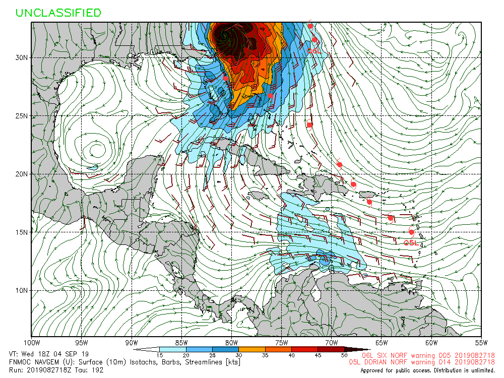
Meanwhile the 18z HWRF shows a Cat 4/5 off the Central Florida coast...
0 likes   
Hurricane Eye Experience: David 79, Irene 99, Frances 04, Jeanne 04, Wilma 05... EYE COMING MY WAY IN 2024…
Hurricane Brush Experience: Andrew 92, Erin 95, Floyd 99, Matthew 16, Irma 17, Ian 22, Nicole 22…

User avatar
Bocadude85
Category 5
Category 5
Posts: 2991
Age: 38
Joined: Mon Apr 18, 2005 2:20 pm
Location: Honolulu,Hi

Re: ATL: DORIAN - Models

#1102 Postby Bocadude85 » Tue Aug 27, 2019 7:30 pm

Hammy wrote:
BobHarlem wrote:For what it's worth, when Irma was at this longitude, (It was further north in latitude) Models had it clipping e. Florida and then making landfall in South Carolina and the official track suggested Savannah.

Link to old Irma model graphic to avoid confusion (Not going to post the image)


Underestimated the ridge?


Also interesting how the UKMET almost nailed Irma’s track 5 days out. Wondering if it could be onto something with the wsw dive it shows Dorian taking in the Bahamas.
1 likes   

User avatar
AdamFirst
S2K Supporter
S2K Supporter
Posts: 2491
Age: 36
Joined: Thu Aug 14, 2008 10:54 am
Location: Port Saint Lucie, FL

Re: ATL: DORIAN - Models

#1103 Postby AdamFirst » Tue Aug 27, 2019 7:34 pm

Bocadude85 wrote:
Also interesting how the UKMET almost nailed Irma’s track 5 days out. Wondering if it could be onto something with the wsw dive it shows Dorian taking in the Bahamas.


UKMET has had various wins in its history. It's probably the best model nobody talks about. Didn't UKMET sniff out Matthew's track as well?
1 likes   
Dolphins Marlins Canes Golden Panthers HEAT
Andrew 1992 - Irene 1999 - Frances 2004 - Jeanne 2004 - Wilma 2005 - Fay 2008 - Isaac 2012 - Matthew 2016 - Irma 2017 - Dorian 2019 - Ian 2022 - Nicole 2022 - Milton 2024

jlauderdal
S2K Supporter
S2K Supporter
Posts: 7183
Joined: Wed May 19, 2004 5:46 am
Location: NE Fort Lauderdale
Contact:

Re: RE: Re: ATL: DORIAN - Models

#1104 Postby jlauderdal » Tue Aug 27, 2019 7:35 pm

Bocadude85 wrote:The models are all over the place, we see this with a lot of Florida storms where they initially show a S.Fla threat and then slowly propagate up to the Carolinas only to swing back south to Florida. Hurricane Irma is a prime example, and we all know how that played out.
Everything seems to have a south florida hit at some point
2 likes   

User avatar
Emmett_Brown
Category 5
Category 5
Posts: 1432
Joined: Wed Aug 24, 2005 9:10 pm
Location: Sarasota FL

Re: ATL: DORIAN - Models

#1105 Postby Emmett_Brown » Tue Aug 27, 2019 7:42 pm

The majority of 18z GFS ensemble members continue to hit the east coast of FL. The a few stronger ones turn N before the FL coast: https://www.weathernerds.org/tc_guidanc ... ?tcid=AL05
0 likes   

Aric Dunn
Category 5
Category 5
Posts: 21238
Age: 42
Joined: Sun Sep 19, 2004 9:58 pm
Location: Ready for the Chase.
Contact:

Re: ATL: DORIAN - Models

#1106 Postby Aric Dunn » Tue Aug 27, 2019 7:43 pm

the ridging in the 18z Euro is interesting..
unlike the GFS's

it continues to build the ridging west. if it kept going possibly even wsw..
1 likes   
Note: If I make a post that is brief. Please refer back to previous posts for the analysis or reasoning. I do not re-write/qoute what my initial post said each time.
If there is nothing before... then just ask :)

Space & Atmospheric Physicist, Embry-Riddle Aeronautical University,
I believe the sky is falling...

User avatar
alienstorm
Category 1
Category 1
Posts: 496
Joined: Tue Jul 31, 2007 1:29 pm
Location: Miami Fla western suburb

Re: ATL: DORIAN - Models

#1107 Postby alienstorm » Tue Aug 27, 2019 7:44 pm

The 18z EURO shows a stout High that turns Dorian westward at 90 hrs it shows Dorian west of Abaco heading west toward South Florida.
1 likes   
Personal Forecast Disclaimer:The posts in this forum are NOT official forecast and should not be used as such. They are just the opinion of the poster and may or may not be backed by sound meteorological data. They are NOT endorsed by any professional institution or storm2k.org. For official information, please refer to the NHC and NWS products.

User avatar
gatorcane
S2K Supporter
S2K Supporter
Posts: 23691
Age: 47
Joined: Sun Mar 13, 2005 3:54 pm
Location: Boca Raton, FL

Re: ATL: DORIAN - Models

#1108 Postby gatorcane » Tue Aug 27, 2019 7:44 pm

HUGE change with the NOGAPS. Now shows a recurve along Florida east coast but looks to not make landfall in Florida:

Image
1 likes   

WeatherEmperor
S2K Supporter
S2K Supporter
Posts: 4806
Age: 41
Joined: Thu Sep 04, 2003 2:54 pm
Location: South Florida

Re: ATL: DORIAN - Models

#1109 Postby WeatherEmperor » Tue Aug 27, 2019 7:46 pm

Aric Dunn wrote:the ridging in the 18z Euro is interesting..
unlike the GFS's

it continues to build the ridging west. if it kept going possibly even wsw..


Are you able to provide an approximate lat and long of the storm as it heads west towards sfla??


Sent from my iPhone using Tapatalk
0 likes   

otowntiger
Category 5
Category 5
Posts: 1921
Joined: Tue Aug 31, 2004 7:06 pm

Re: ATL: DORIAN - Models

#1110 Postby otowntiger » Tue Aug 27, 2019 7:47 pm

It seems as if a recurve or at least curve well north of Florida is now on the table looking at several models such as GFS, legacy GFS, JMA, to name a few.
0 likes   

WeatherEmperor
S2K Supporter
S2K Supporter
Posts: 4806
Age: 41
Joined: Thu Sep 04, 2003 2:54 pm
Location: South Florida

Re: ATL: DORIAN - Models

#1111 Postby WeatherEmperor » Tue Aug 27, 2019 7:47 pm

gatorcane wrote:HUGE change with the NOGAPS. Now shows a recurve along Florida east coast but looks to not make landfall in Florida:

Image


Where have we seen this movie before? The models show hit after hit on florida only to change and turn north to the carolinas or out to sea lol


Sent from my iPhone using Tapatalk
0 likes   

beachman80

Re: ATL: DORIAN - Models

#1112 Postby beachman80 » Tue Aug 27, 2019 7:48 pm

That Ridge is the ball game. It's also the ball game for the GOM. If it's strong it gets in the GOM. If it's weak, it could ride up the east coast or miss the States altogether.
0 likes   

User avatar
Blown Away
S2K Supporter
S2K Supporter
Posts: 10147
Joined: Wed May 26, 2004 6:17 am

Re: ATL: DORIAN - Models

#1113 Postby Blown Away » Tue Aug 27, 2019 7:50 pm

Image

Something getting fishy on 00z guidance for the CONUS...
1 likes   
Hurricane Eye Experience: David 79, Irene 99, Frances 04, Jeanne 04, Wilma 05... EYE COMING MY WAY IN 2024…
Hurricane Brush Experience: Andrew 92, Erin 95, Floyd 99, Matthew 16, Irma 17, Ian 22, Nicole 22…

Aric Dunn
Category 5
Category 5
Posts: 21238
Age: 42
Joined: Sun Sep 19, 2004 9:58 pm
Location: Ready for the Chase.
Contact:

Re: ATL: DORIAN - Models

#1114 Postby Aric Dunn » Tue Aug 27, 2019 7:50 pm

WeatherEmperor wrote:
Aric Dunn wrote:the ridging in the 18z Euro is interesting..
unlike the GFS's

it continues to build the ridging west. if it kept going possibly even wsw..


Are you able to provide an approximate lat and long of the storm as it heads west towards sfla??


Sent from my iPhone using Tapatalk


[img]https://twitter.com/ryanmaue/status/1166505098589147136[/img]
0 likes   
Note: If I make a post that is brief. Please refer back to previous posts for the analysis or reasoning. I do not re-write/qoute what my initial post said each time.
If there is nothing before... then just ask :)

Space & Atmospheric Physicist, Embry-Riddle Aeronautical University,
I believe the sky is falling...

WeatherEmperor
S2K Supporter
S2K Supporter
Posts: 4806
Age: 41
Joined: Thu Sep 04, 2003 2:54 pm
Location: South Florida

Re: ATL: DORIAN - Models

#1115 Postby WeatherEmperor » Tue Aug 27, 2019 7:53 pm

Aric Dunn wrote:
WeatherEmperor wrote:
Aric Dunn wrote:the ridging in the 18z Euro is interesting..
unlike the GFS's

it continues to build the ridging west. if it kept going possibly even wsw..


Are you able to provide an approximate lat and long of the storm as it heads west towards sfla??


Sent from my iPhone using Tapatalk


[img]https://twitter.com/ryanmaue/status/1166505098589147136[/img]


Sorry Aric. Appears to be broken link. Cannot see it


Sent from my iPhone using Tapatalk
0 likes   

User avatar
Hypercane_Kyle
Category 5
Category 5
Posts: 3352
Joined: Sat Mar 07, 2015 7:58 pm
Location: Cape Canaveral, FL

Re: ATL: DORIAN - Models

#1116 Postby Hypercane_Kyle » Tue Aug 27, 2019 7:54 pm

Hammy wrote:
BobHarlem wrote:For what it's worth, when Irma was at this longitude, (It was further north in latitude) Models had it clipping e. Florida and then making landfall in South Carolina and the official track suggested Savannah.

Link to old Irma model graphic to avoid confusion (Not going to post the image)


Underestimated the ridge?


Yes. The ECMWF was the only model (IIRC, maybe the UKMET too) that correctly saw the ridge being stronger and thus Irma ended up being further west (west coast of FL) by the time it took the turn north. As you know, Irma ended up hitting Cuba, when most of the US models showed Irma going well north of Cuba.

I'd be interested in seeing how the ECMWF has done in predicting the 500mb setup vs the rest of the models over the last 5 days, if anyone has something like that.
0 likes   
My posts are my own personal opinion, defer to the National Hurricane Center (NHC) and other NOAA products for decision making during hurricane season.

Aric Dunn
Category 5
Category 5
Posts: 21238
Age: 42
Joined: Sun Sep 19, 2004 9:58 pm
Location: Ready for the Chase.
Contact:

Re: ATL: DORIAN - Models

#1117 Postby Aric Dunn » Tue Aug 27, 2019 7:55 pm

WeatherEmperor wrote:
Aric Dunn wrote:
WeatherEmperor wrote:
Are you able to provide an approximate lat and long of the storm as it heads west towards sfla??


Sent from my iPhone using Tapatalk


[url][url]https://twitter.com/ryanmaue/status/1166505098589147136[/url][/url]


Sorry Aric. Appears to be broken link. Cannot see it


Sent from my iPhone using Tapatalk


https://twitter.com/ryanmaue/status/1166505098589147136
0 likes   
Note: If I make a post that is brief. Please refer back to previous posts for the analysis or reasoning. I do not re-write/qoute what my initial post said each time.
If there is nothing before... then just ask :)

Space & Atmospheric Physicist, Embry-Riddle Aeronautical University,
I believe the sky is falling...

User avatar
gatorcane
S2K Supporter
S2K Supporter
Posts: 23691
Age: 47
Joined: Sun Mar 13, 2005 3:54 pm
Location: Boca Raton, FL

Re: ATL: DORIAN - Models

#1118 Postby gatorcane » Tue Aug 27, 2019 7:56 pm

TVCN yet again north of NHC. Trend has been north with the models all day, will it continue?

Image
0 likes   

User avatar
toad strangler
S2K Supporter
S2K Supporter
Posts: 4543
Joined: Sun Jul 28, 2013 3:09 pm
Location: Earth
Contact:

Re: ATL: DORIAN - Models

#1119 Postby toad strangler » Tue Aug 27, 2019 7:58 pm

I posted Maue’s Tweet with the 18z Euro graphic a page back

Post #1100
0 likes   

User avatar
toad strangler
S2K Supporter
S2K Supporter
Posts: 4543
Joined: Sun Jul 28, 2013 3:09 pm
Location: Earth
Contact:

Re: ATL: DORIAN - Models

#1120 Postby toad strangler » Tue Aug 27, 2019 8:02 pm

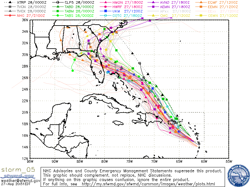
gatorcane wrote:TVCN yet again north of NHC. Trend has been north with the models all day, will it continue?

https://i.postimg.cc/RVRGf11D/storm-05-ens.gif


We’ve seen it before!
0 likes   


Return to “2019”

Who is online

Users browsing this forum: No registered users and 11 guests