

ATL: INVEST 91L - Discussion
Moderator: S2k Moderators
Re: ATL: INVEST 91L - Discussion
Definitely getting better organized this morning, but circulation still remains broad and elongated, the coast's shape will help it to tighten up over the next couple of days.
2 likes
-
Aric Dunn
- Category 5

- Posts: 21238
- Age: 43
- Joined: Sun Sep 19, 2004 9:58 pm
- Location: Ready for the Chase.
- Contact:
Re: ATL: INVEST 91L - Discussion
radar is looking low to mid levels. but clearly showing increased circulation.
https://smn.conagua.gob.mx/es/observand ... orologicos
https://smn.conagua.gob.mx/es/observand ... orologicos
1 likes
Note: If I make a post that is brief. Please refer back to previous posts for the analysis or reasoning. I do not re-write/qoute what my initial post said each time.
If there is nothing before... then just ask
Space & Atmospheric Physicist, Embry-Riddle Aeronautical University,
I believe the sky is falling...
If there is nothing before... then just ask
Space & Atmospheric Physicist, Embry-Riddle Aeronautical University,
I believe the sky is falling...
-
Aric Dunn
- Category 5
- Posts: 21238
- Age: 43
- Joined: Sun Sep 19, 2004 9:58 pm
- Location: Ready for the Chase.
- Contact:
Re: ATL: INVEST 91L - Discussion
1 likes
Note: If I make a post that is brief. Please refer back to previous posts for the analysis or reasoning. I do not re-write/qoute what my initial post said each time.
If there is nothing before... then just ask
Space & Atmospheric Physicist, Embry-Riddle Aeronautical University,
I believe the sky is falling...
If there is nothing before... then just ask
Space & Atmospheric Physicist, Embry-Riddle Aeronautical University,
I believe the sky is falling...
-
Hypercane_Kyle

- Category 5
- Posts: 3465
- Joined: Sat Mar 07, 2015 7:58 pm
- Location: Cape Canaveral, FL
Re: ATL: INVEST 91L - Discussion
I wouldn't be surprised if this spins up into a modest tropical storm. Looks like it's going to be hanging out for a few days nosing around the edge of a ridge in the GOMEX.
1 likes
My posts are my own personal opinion, defer to the National Hurricane Center (NHC) and other NOAA products for decision making during hurricane season.
-
Dean4Storms
- S2K Supporter

- Posts: 6358
- Age: 63
- Joined: Sun Aug 31, 2003 1:01 pm
- Location: Miramar Bch. FL
Re: ATL: INVEST 91L - Discussion
More and more organization taking place, has a real shot at becoming a TS IMO. The timing of that ULL coming eastward from the SW CONUS is going to be key on how much it gets inland or stays offshore for TX down the road. But lots of rain is almost a certainty, at least for Southern TX at this point.
0 likes
-
tropicwatch

- Category 5
- Posts: 3426
- Age: 62
- Joined: Sat Jun 02, 2007 10:01 am
- Location: Panama City Florida
- Contact:
Re: ATL: INVEST 91L - Discussion
Dean4Storms wrote:More and more organization taking place, has a real shot at becoming a TS IMO. The timing of that ULL coming eastward from the SW CONUS is going to be key on how much it gets inland or stays offshore for TX down the road. But lots of rain is almost a certainty, at least for Southern TX at this point.
The high over the southeast will also be a factor.
0 likes
Tropicwatch
Agnes 72', Eloise 75, Elena 85', Kate 85', Charley 86', Florence 88', Beryl 94', Dean 95', Erin 95', Opal 95', Earl 98', Georges 98', Ivan 2004', Arlene 2005', Dennis 2005', Ida 2009' Debby 2012' Irma 2017' Michael 2018'
Agnes 72', Eloise 75, Elena 85', Kate 85', Charley 86', Florence 88', Beryl 94', Dean 95', Erin 95', Opal 95', Earl 98', Georges 98', Ivan 2004', Arlene 2005', Dennis 2005', Ida 2009' Debby 2012' Irma 2017' Michael 2018'
Re: ATL: INVEST 91L - Discussion
Looks pretty good. BOC gonna BOC. IIRC 2005 featured a bunch of short lived storms in that region...for such a small area it can be pretty prolific.
0 likes
-
cycloneye

- Admin

- Posts: 149275
- Age: 69
- Joined: Thu Oct 10, 2002 10:54 am
- Location: San Juan, Puerto Rico
Re: ATL: INVEST 91L - Discussion
Great discussion from Levi Cowan in this video:
https://twitter.com/TropicalTidbits/sta ... 0387103750
https://twitter.com/TropicalTidbits/sta ... 0387103750
0 likes
Visit the Caribbean-Central America Weather Thread where you can find at first post web cams,radars
and observations from Caribbean basin members Click Here
and observations from Caribbean basin members Click Here
-
AnnularCane

- S2K Supporter
- Posts: 2957
- Joined: Thu Jun 08, 2006 9:18 am
- Location: Wytheville, VA
Re: ATL: INVEST 91L - Discussion
Didn't the 2007 season start off with Barry too? I might be feeling a bit of deja vu here (even though that was on the other side of the Gulf).
0 likes

-
MGC

- S2K Supporter
- Posts: 5940
- Joined: Sun Mar 23, 2003 9:05 pm
- Location: Pass Christian MS, or what is left.
Re: ATL: INVEST 91L - Discussion
91L looks to be on the move....thus I don't think it will have enough time to develop into a tropical system. But never under estimate the BOC. I'm thinking a 25% chance of development before reaching the beach.....MGC
1 likes
-
BYG Jacob
Re: ATL: INVEST 91L - Discussion
https://www.youtube.com/watch?v=c6zwPOwDshU
Levi with a video, we're back gang. Welcome to 2019
Levi with a video, we're back gang. Welcome to 2019
0 likes
-
cycloneye
- Admin
- Posts: 149275
- Age: 69
- Joined: Thu Oct 10, 2002 10:54 am
- Location: San Juan, Puerto Rico
Re: ATL: INVEST 91L - Discussion
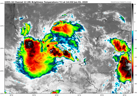
60% /60%
Tropical Weather Outlook
NWS National Hurricane Center Miami FL
200 PM EDT Sat Jun 1 2019
For the North Atlantic...Caribbean Sea and the Gulf of Mexico:
Recent satellite data indicate that circulation of a low pressure
system located over the southern Bay of Campeche has become a little
better defined today. However, the associated showers and
thunderstorms remain disorganized. This system is expected to move
slowly west-northwestward toward the coast of Mexico, and it could
become a tropical cyclone before it moves inland early next week.
Regardless of development, the disturbance will likely produce heavy
rainfall over portions of southern and eastern Mexico during the
next few days. An Air Force Reserve reconnaissance aircraft is
scheduled to investigate the disturbance on Sunday, if necessary.
Interests along the Gulf coast of Mexico should monitor the progress
of this system.
* Formation chance through 48 hours...medium...60 percent.
* Formation chance through 5 days...medium...60 percent.
$$
Forecaster Cangialosi
2 likes
Visit the Caribbean-Central America Weather Thread where you can find at first post web cams,radars
and observations from Caribbean basin members Click Here
and observations from Caribbean basin members Click Here
-
Aric Dunn
- Category 5
- Posts: 21238
- Age: 43
- Joined: Sun Sep 19, 2004 9:58 pm
- Location: Ready for the Chase.
- Contact:
Re: ATL: INVEST 91L - Discussion
I am not surprised with that outlook. Looks to be quickly organizing
0 likes
Note: If I make a post that is brief. Please refer back to previous posts for the analysis or reasoning. I do not re-write/qoute what my initial post said each time.
If there is nothing before... then just ask
Space & Atmospheric Physicist, Embry-Riddle Aeronautical University,
I believe the sky is falling...
If there is nothing before... then just ask
Space & Atmospheric Physicist, Embry-Riddle Aeronautical University,
I believe the sky is falling...
-
cycloneye
- Admin
- Posts: 149275
- Age: 69
- Joined: Thu Oct 10, 2002 10:54 am
- Location: San Juan, Puerto Rico
Re: ATL: INVEST 91L - Discussion
https://twitter.com/Weathernerds/status/1134875357952303105
https://twitter.com/TropicalTidbits/status/1134877014006075392
https://twitter.com/TropicalTidbits/status/1134877014006075392
1 likes
Visit the Caribbean-Central America Weather Thread where you can find at first post web cams,radars
and observations from Caribbean basin members Click Here
and observations from Caribbean basin members Click Here
-
Aric Dunn
- Category 5
- Posts: 21238
- Age: 43
- Joined: Sun Sep 19, 2004 9:58 pm
- Location: Ready for the Chase.
- Contact:
Re: ATL: INVEST 91L - Discussion
yeah I was going to say the wind barbs dont make sense to what is actually happening the surface. disregard that ascat pass. too much ambiguity.
still well on its way.
still well on its way.
0 likes
Note: If I make a post that is brief. Please refer back to previous posts for the analysis or reasoning. I do not re-write/qoute what my initial post said each time.
If there is nothing before... then just ask
Space & Atmospheric Physicist, Embry-Riddle Aeronautical University,
I believe the sky is falling...
If there is nothing before... then just ask
Space & Atmospheric Physicist, Embry-Riddle Aeronautical University,
I believe the sky is falling...
-
cycloneye
- Admin
- Posts: 149275
- Age: 69
- Joined: Thu Oct 10, 2002 10:54 am
- Location: San Juan, Puerto Rico
Re: ATL: INVEST 91L - Discussion
18z Best Track:

Location: 19.7°N 94.0°W
Maximum Winds: 20 kt Gusts: N/A
Minimum Central Pressure: 1008 mb
Environmental Pressure: 1010 mb
Radius of Circulation: 120 NM
Radius of Maximum Wind: 70 NM
Maximum Winds: 20 kt Gusts: N/A
Minimum Central Pressure: 1008 mb
Environmental Pressure: 1010 mb
Radius of Circulation: 120 NM
Radius of Maximum Wind: 70 NM
0 likes
Visit the Caribbean-Central America Weather Thread where you can find at first post web cams,radars
and observations from Caribbean basin members Click Here
and observations from Caribbean basin members Click Here
-
BYG Jacob
-
TheStormExpert
Re: ATL: INVEST 91L - Discussion
AnnularCane wrote:Didn't the 2007 season start off with Barry too? I might be feeling a bit of deja vu here (even though that was on the other side of the Gulf).
2013 also had Barry in the BoC in June.
1 likes
-
TheStormExpert
Re: ATL: INVEST 91L - Discussion
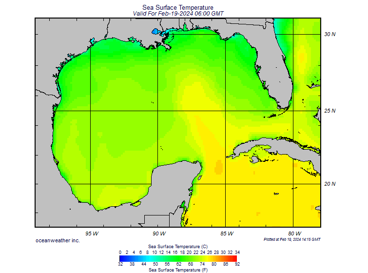
BYG Jacob wrote:Water more than warm enough to support a hurricane
https://www.oceanweather.com/data/Gulf-of-Mexico/SST.GIF
Dropping to “H” word I see!
2 likes
Who is online
Users browsing this forum: No registered users and 24 guests