ATL: PABLO - Post-Tropical - Discussion
Moderator: S2k Moderators

Re: ATL: INVEST 98L - Discussion
There’s an 80% chance they will issue advisories... 100% chance it’s already a (S)TC. 
1 likes
-
northjaxpro

- S2K Supporter

- Posts: 8900
- Joined: Mon Sep 27, 2010 11:21 am
- Location: Jacksonville, FL
Re: ATL: INVEST 98L - Discussion
Well, we all know this is a TC, no question in my mind it is. NHC will name it. Will it be before TD 17 or not? I tend to think TD 17 will be named Olga first as it is of extreme urgency to get those watches and warnings posted asap to folks along the Gulf Coast. Recon is about to get in there shortly to confirm we have TS down in the GOM.
1 likes
NEVER, EVER SAY NEVER in the tropics and weather in general, and most importantly, with life itself!!
________________________________________________________________________________________
Fay 2008 Beryl 2012 Debby 2012 Colin 2016 Hermine 2016 Julia 2016 Matthew 2016 Irma 2017 Dorian 2019
________________________________________________________________________________________
Fay 2008 Beryl 2012 Debby 2012 Colin 2016 Hermine 2016 Julia 2016 Matthew 2016 Irma 2017 Dorian 2019
-
EquusStorm
- Category 5

- Posts: 1649
- Age: 35
- Joined: Thu Nov 07, 2013 1:04 pm
- Location: Jasper, AL
- Contact:
Re: ATL: INVEST 98L - Discussion
Pretty sure they're waiting on the 5pm advisory cycle to classify it; though they certainly could issue a special advisory as it is objectively 100% a TS/STS, I guess without an imminent threat to land they can wait a couple hours. Postanalysis will find it developed this morning though.
1 likes
Colors of lost purpose on the canvas of irrelevance
Not a meteorologist, in fact more of an idiot than anything. You should probably check with the NHC or a local NWS office for official information.
Not a meteorologist, in fact more of an idiot than anything. You should probably check with the NHC or a local NWS office for official information.

Re: ATL: INVEST 98L - Discussion
northjaxpro wrote:Well, we all know this is a TC, no question in my mind it is. NHC will name it. Will it be before TD 17 or not? I tend to think TD 17 will be named Olga first as it is of extreme urgency to get those watches and warnings posted asap to folks along the Gulf Coast. Recon is about to get in there shortly to confirm we have TS down in the GOM.
Yeah, TD17 will get it now.
We will have a slightly daft situation however where probably post season this one will have formation to be pushed back to before Olga was formed, so we will have Pablo before Olga I suspect come post season!
I can only imagine the NHC want to see it hold this formation a little longer as sometimes these types of systems can unravel in mere hours, but at the moment I have no doubts this is a TS.
0 likes
Personal Forecast Disclaimer:
The posts in this forum are NOT official forecast and should not be used as such. They are just the opinion of the poster and may or may not be backed by sound meteorological data. They are NOT endorsed by any professional institution or storm2k.org. For official information, please refer to the NHC and NWS products
The posts in this forum are NOT official forecast and should not be used as such. They are just the opinion of the poster and may or may not be backed by sound meteorological data. They are NOT endorsed by any professional institution or storm2k.org. For official information, please refer to the NHC and NWS products
-
EquusStorm
- Category 5
- Posts: 1649
- Age: 35
- Joined: Thu Nov 07, 2013 1:04 pm
- Location: Jasper, AL
- Contact:
Re: ATL: INVEST 98L - Discussion
Assuming 17L is upgraded to TS at all.18z ATCF shows 98L at 45kt. Might have two storms to upgrade to TS and the NHC struggling over which one gets which name lol
0 likes
Colors of lost purpose on the canvas of irrelevance
Not a meteorologist, in fact more of an idiot than anything. You should probably check with the NHC or a local NWS office for official information.
Not a meteorologist, in fact more of an idiot than anything. You should probably check with the NHC or a local NWS office for official information.


-
northjaxpro
- S2K Supporter
- Posts: 8900
- Joined: Mon Sep 27, 2010 11:21 am
- Location: Jacksonville, FL
Re: ATL: INVEST 98L - Discussion
Man that sure looks like a mini Cane doesn't it folks. Interesting indeed....
0 likes
NEVER, EVER SAY NEVER in the tropics and weather in general, and most importantly, with life itself!!
________________________________________________________________________________________
Fay 2008 Beryl 2012 Debby 2012 Colin 2016 Hermine 2016 Julia 2016 Matthew 2016 Irma 2017 Dorian 2019
________________________________________________________________________________________
Fay 2008 Beryl 2012 Debby 2012 Colin 2016 Hermine 2016 Julia 2016 Matthew 2016 Irma 2017 Dorian 2019
-
lrak

- S2K Supporter
- Posts: 1770
- Age: 59
- Joined: Thu Jun 21, 2007 2:48 pm
- Location: Corpus Christi, TX
Re: ATL: INVEST 98L - Discussion
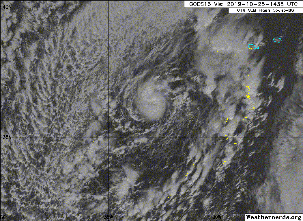
It is strange that the NHC hasn't named 98L yet. The visible and all the other satellite views show an eye?


Last edited by lrak on Fri Oct 25, 2019 1:35 pm, edited 2 times in total.
1 likes
AKA karl
Also
Personal Forecast Disclaimer:
My posts on this forum are NOT official forecast and should not be used as such. My posts are my basic observations and are definitely not backed by any "well some" meteorological knowledge. For official information, please refer to the NHC and NWS products.
Also
Personal Forecast Disclaimer:
My posts on this forum are NOT official forecast and should not be used as such. My posts are my basic observations and are definitely not backed by any "well some" meteorological knowledge. For official information, please refer to the NHC and NWS products.
-
Sciencerocks
- Category 5
- Posts: 10181
- Age: 40
- Joined: Thu Jul 06, 2017 1:51 am
-
AnnularCane

- S2K Supporter
- Posts: 2957
- Joined: Thu Jun 08, 2006 9:18 am
- Location: Wytheville, VA
-
northjaxpro
- S2K Supporter
- Posts: 8900
- Joined: Mon Sep 27, 2010 11:21 am
- Location: Jacksonville, FL
Re: ATL: INVEST 98L - Discussion
I tell you what, it is a tiny cyclone, but extremely well developed eye-like structure. What a unique cyclone!
Last edited by northjaxpro on Fri Oct 25, 2019 2:03 pm, edited 1 time in total.
0 likes
NEVER, EVER SAY NEVER in the tropics and weather in general, and most importantly, with life itself!!
________________________________________________________________________________________
Fay 2008 Beryl 2012 Debby 2012 Colin 2016 Hermine 2016 Julia 2016 Matthew 2016 Irma 2017 Dorian 2019
________________________________________________________________________________________
Fay 2008 Beryl 2012 Debby 2012 Colin 2016 Hermine 2016 Julia 2016 Matthew 2016 Irma 2017 Dorian 2019
-
cycloneye

- Admin

- Posts: 149275
- Age: 69
- Joined: Thu Oct 10, 2002 10:54 am
- Location: San Juan, Puerto Rico
Re: ATL: INVEST 98L - Discussion
AL, 98, 2019102518, , BEST, 0, 360N, 327W, 45, 990, LO
0 likes
Visit the Caribbean-Central America Weather Thread where you can find at first post web cams,radars
and observations from Caribbean basin members Click Here
and observations from Caribbean basin members Click Here

Re: ATL: INVEST 98L - Discussion
cycloneye wrote:AL, 98, 2019102518, , BEST, 0, 360N, 327W, 45, 990, LO
They seem extremely unwilling to name anything today between this and TD17.
1 likes
The above post is not official and should not be used as such. It is the opinion of the poster and may or may not be backed by sound meteorological data. It is not endorsed by any professional institution or storm2k.org. For official information, please refer to the NHC and NWS products.

Re: ATL: INVEST 98L - Discussion
From the 2 pm ET Tropical Weather Outlook:
“Shower activity continues to become better organized in association with a small-scale low pressure area embedded within a larger extratropical low centered a few hundred miles southwest of the Azores. If current trends continue, advisories on a tropical or subtropical cyclone could be initiated later today. The low is forecast to move toward the east-northeast, and interests in the Azores should monitor the progress of this system. For more information, see High Seas Forecast issued by Meteo France.
Formation chance through 48 hours...high...80 percent.
Formation chance through 5 days...high...80 percent.”
The next available name will be Pablo, which will bring 2019’s named storm total above that of 2018.
0 likes
Irene '11 Sandy '12 Hermine '16 5/15/2018 Derecho Fay '20 Isaias '20 Elsa '21 Henri '21 Ida '21
I am only a meteorology enthusiast who knows a decent amount about tropical cyclones. Look to the professional mets, the NHC, or your local weather office for the best information.
I am only a meteorology enthusiast who knows a decent amount about tropical cyclones. Look to the professional mets, the NHC, or your local weather office for the best information.
-
EquusStorm
- Category 5
- Posts: 1649
- Age: 35
- Joined: Thu Nov 07, 2013 1:04 pm
- Location: Jasper, AL
- Contact:
Re: ATL: INVEST 98L - Discussion
ATCF says AL18. Will be TS/STS at 5 unless NHC goes against.
0 likes
Colors of lost purpose on the canvas of irrelevance
Not a meteorologist, in fact more of an idiot than anything. You should probably check with the NHC or a local NWS office for official information.
Not a meteorologist, in fact more of an idiot than anything. You should probably check with the NHC or a local NWS office for official information.
-
cycloneye
- Admin
- Posts: 149275
- Age: 69
- Joined: Thu Oct 10, 2002 10:54 am
- Location: San Juan, Puerto Rico
Re: ATL: INVEST 98L - Discussion
cycloneye wrote:AL, 98, 2019102518, , BEST, 0, 360N, 327W, 45, 990, LO
ATCF updates the best track to upgrade.
AL, 18, 2019102518, , BEST, 0, 360N, 327W, 40, 990, TS, 34, NEQ, 0, 0, 0, 20, 1011, 150, 20, 50, 0, L, 0, , 0, 0, PABLO, M
0 likes
Visit the Caribbean-Central America Weather Thread where you can find at first post web cams,radars
and observations from Caribbean basin members Click Here
and observations from Caribbean basin members Click Here
Re: ATL: INVEST 98L - Discussion
cycloneye wrote:cycloneye wrote:AL, 98, 2019102518, , BEST, 0, 360N, 327W, 45, 990, LO
ATCF updates the best track to upgrade.
AL, 18, 2019102518, , BEST, 0, 360N, 327W, 40, 990, TS, 34, NEQ, 0, 0, 0, 20, 1011, 150, 20, 50, 0, L, 0, , 0, 0, PABLO, M
About time, that was getting a little bit ridiculous! Relatively shallow convection, wouldn't shock me if 40kts is a fair whack too low, I'd say its a classic 55kts looking NE TS at the moment.
I don't think its going to last long either, already looking a touch elongated W-E.
0 likes
Personal Forecast Disclaimer:
The posts in this forum are NOT official forecast and should not be used as such. They are just the opinion of the poster and may or may not be backed by sound meteorological data. They are NOT endorsed by any professional institution or storm2k.org. For official information, please refer to the NHC and NWS products
The posts in this forum are NOT official forecast and should not be used as such. They are just the opinion of the poster and may or may not be backed by sound meteorological data. They are NOT endorsed by any professional institution or storm2k.org. For official information, please refer to the NHC and NWS products
-
wxman57

- Moderator-Pro Met

- Posts: 23172
- Age: 68
- Joined: Sat Jun 21, 2003 8:06 pm
- Location: Houston, TX (southwest)
Re: ATL: INVEST 98L - Discussion
northjaxpro wrote:Man that sure looks like a mini Cane doesn't it folks. Interesting indeed....
West Gulf frontal low will get a name but this hurricane is only a “disturbance”. Makes a difference where something is located, I suppose. What if this system was in the NW Gulf with its pinhole eye?
2 likes
-
EquusStorm
- Category 5
- Posts: 1649
- Age: 35
- Joined: Thu Nov 07, 2013 1:04 pm
- Location: Jasper, AL
- Contact:
Re: ATL: INVEST 98L - Discussion
Not sure I personally would have upgraded the Gulf storm and would have definitely upgraded this at 11am, but eh, more for the statistics I guess
0 likes
Colors of lost purpose on the canvas of irrelevance
Not a meteorologist, in fact more of an idiot than anything. You should probably check with the NHC or a local NWS office for official information.
Not a meteorologist, in fact more of an idiot than anything. You should probably check with the NHC or a local NWS office for official information.
Re: ATL: INVEST 98L - Discussion
And there goes the eye. It was cool while it lasted.
0 likes
Irene '11 Sandy '12 Hermine '16 5/15/2018 Derecho Fay '20 Isaias '20 Elsa '21 Henri '21 Ida '21
I am only a meteorology enthusiast who knows a decent amount about tropical cyclones. Look to the professional mets, the NHC, or your local weather office for the best information.
I am only a meteorology enthusiast who knows a decent amount about tropical cyclones. Look to the professional mets, the NHC, or your local weather office for the best information.
Who is online
Users browsing this forum: No registered users and 131 guests