ATL: DORIAN - Post-Tropical - Discussion

Moderator: S2k Moderators

Message
Author
Patrick99
Category 5
Category 5
Posts: 1772
Joined: Mon May 24, 2004 3:43 pm
Location: SW Broward, FL

Re: ATL: DORIAN - Hurricane - Discussion

#2621 Postby Patrick99 » Thu Aug 29, 2019 10:07 am

ObsessedMiami wrote:
SconnieCane wrote:
Evil Jeremy wrote:So we've progressed from a Dorian that would have turned north into the weakness left by Erin if it was moving quicker, to a Dorian held under the ridge by moving at a normal speed, now to a Dorian that would turn north by moving so slow another weakness opens up. And still, no one really has a confident clue how this will play out.


While in theory I know that weather prediction models have improved dramatically over the last 20-25 or so years, it rarely feels that way in practice. It seems with every suite of model runs there is a new "consensus" wildly different from the previous. Maybe it's because 20 years ago, the limitations were such that no one bothered even trying to put out public forecasts for things like severe weather and tropical cyclones beyond five days, and even those were rare with most being limited to three days.


The thing that is interesting to me is how model watching is an example of our modern instant internet gratification mindset. We are trained to want more information faster and believe each new data set holds the key to understanding. So we gorge on every single model run thinking that all that overload of information will gives us THE ANSWER and allow us TO KNOW before anyone else. So people put instant value on information that is best digested over time. But we want to know NOW. And it frustrates us. This is why you see literally back to back posts on here, one person saying it looks ragged and another saying its clearly intensifying. The clearest trends in Dorian watching occur in the people, not the data.

Just an observation and I am mostly analyzing myself.


Yeah, and then you get people rooting for and following one particular model they like for whatever reason, as if the model is a football team that cares about winning out over its competitors.
4 likes   

User avatar
Buck
S2K Supporter
S2K Supporter
Posts: 1174
Joined: Fri Sep 10, 2004 12:04 pm
Location: Atlanta, GA

Re: ATL: DORIAN - Hurricane - Discussion

#2622 Postby Buck » Thu Aug 29, 2019 10:07 am

Wow, officially up to a Category 4 (130mph) at landfall in forecast.

Today might be interesting if Dorian decides to undergo any rapid intensification. I suppose we won't see any watches or warnings issued until late tonight or early in the morning, so 6-hour advisories it is... but if he RIs, I guess we might see some special advisories issued.
2 likes   

TheStormExpert

Re: ATL: DORIAN - Hurricane - Discussion

#2623 Postby TheStormExpert » Thu Aug 29, 2019 10:08 am

Feeling a bit better with the latest trends.
0 likes   

User avatar
northjaxpro
S2K Supporter
S2K Supporter
Posts: 8900
Joined: Mon Sep 27, 2010 11:21 am
Location: Jacksonville, FL

Re: ATL: DORIAN - Hurricane - Discussion

#2624 Postby northjaxpro » Thu Aug 29, 2019 10:09 am

SouthFLTropics wrote:In all of my years going through storms I have never left for one. We are leaving for this one. The fact that it is a 4 day holiday weekend makes it a little easier of a decision. Also, the fact that I can now load up a lot of what we have into our fifth wheel and take it with us. Going to button up the house later this evening, hook up the trailer and head out tonight. I'm gonna watch this one on TV.


A very astute decision SouthFLTropics!! Be safe out there!
1 likes   
NEVER, EVER SAY NEVER in the tropics and weather in general, and most importantly, with life itself!!

________________________________________________________________________________________

Fay 2008 Beryl 2012 Debby 2012 Colin 2016 Hermine 2016 Julia 2016 Matthew 2016 Irma 2017 Dorian 2019

jlauderdal
S2K Supporter
S2K Supporter
Posts: 7190
Joined: Wed May 19, 2004 5:46 am
Location: NE Fort Lauderdale
Contact:

Re: ATL: DORIAN - Hurricane - Discussion

#2625 Postby jlauderdal » Thu Aug 29, 2019 10:10 am

TheStormExpert wrote:Feeling a bit better with the latest trends.
which trends are those, you are in real danger of a direct hit?
0 likes   

tolakram
Admin
Admin
Posts: 20020
Age: 62
Joined: Sun Aug 27, 2006 8:23 pm
Location: Florence, KY (name is Mark)

Re: ATL: DORIAN - Hurricane - Discussion

#2626 Postby tolakram » Thu Aug 29, 2019 10:12 am

northjaxpro wrote:
SouthFLTropics wrote:In all of my years going through storms I have never left for one. We are leaving for this one. The fact that it is a 4 day holiday weekend makes it a little easier of a decision. Also, the fact that I can now load up a lot of what we have into our fifth wheel and take it with us. Going to button up the house later this evening, hook up the trailer and head out tonight. I'm gonna watch this one on TV.


A very astute decision SouthFLTropics!! Be safe out there!


It's a good time to remind people that while a huge cat 4 will be devastating where it hits the real problem is going to be a large swatch of moderate damage, electricity off, downed limbs, impassible roads, possibly contaminated water due to heavy rains. This is what does the most harm and ends up causing the most deaths. Even if you're not directly in the path you may have to deal with the aftereffects for a while.
6 likes   
M a r k
- - - - -
Join us in chat: Storm2K Chatroom Invite. Android and IOS apps also available.

The posts in this forum are NOT official forecasts and should not be used as such. Posts are NOT endorsed by any professional institution or STORM2K.org. For official information and forecasts, please refer to NHC and NWS products.

supercane4867
Category 5
Category 5
Posts: 4966
Joined: Wed Nov 14, 2012 10:43 am

Re: ATL: DORIAN - Hurricane - Discussion

#2627 Postby supercane4867 » Thu Aug 29, 2019 10:12 am

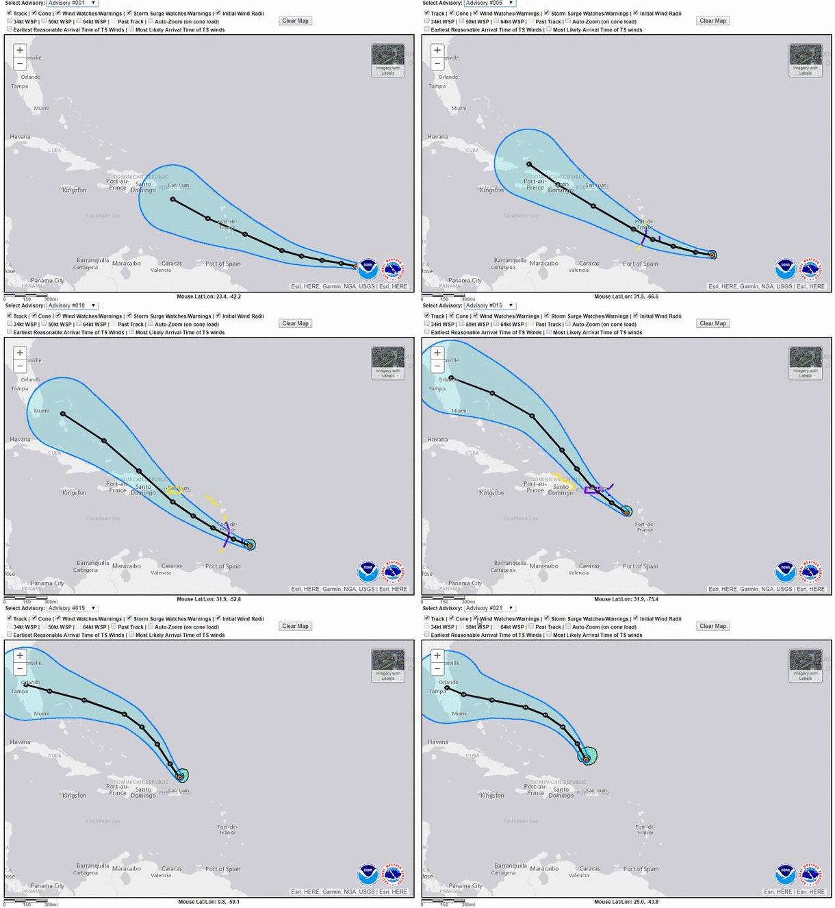
Updated cones

Image
5 likes   

norva13x
Tropical Storm
Tropical Storm
Posts: 102
Joined: Fri Sep 01, 2017 10:41 am

Re: ATL: DORIAN - Hurricane - Discussion

#2628 Postby norva13x » Thu Aug 29, 2019 10:13 am

TheStormExpert wrote:Feeling a bit better with the latest trends.


Not me. I don't buy the curve offshore yet and if it hits south or south central Florida then turns north it's bad news us here for Orlando. Maybe it will windshield wipe back out to sea and keep trending offshore but I don't think so personally. I'm far from an expert of course.
2 likes   

TheStormExpert

Re: ATL: DORIAN - Hurricane - Discussion

#2629 Postby TheStormExpert » Thu Aug 29, 2019 10:15 am

jlauderdal wrote:
TheStormExpert wrote:Feeling a bit better with the latest trends.
which trends are those, you are in real danger of a direct hit?

The northward trends.
0 likes   

Aric Dunn
Category 5
Category 5
Posts: 21238
Age: 42
Joined: Sun Sep 19, 2004 9:58 pm
Location: Ready for the Chase.
Contact:

Re: ATL: DORIAN - Hurricane - Discussion

#2630 Postby Aric Dunn » Thu Aug 29, 2019 10:15 am


That is actually pretty amazing consistency..
1 likes   
Note: If I make a post that is brief. Please refer back to previous posts for the analysis or reasoning. I do not re-write/qoute what my initial post said each time.
If there is nothing before... then just ask :)

Space & Atmospheric Physicist, Embry-Riddle Aeronautical University,
I believe the sky is falling...

User avatar
cjrciadt
S2K Supporter
S2K Supporter
Posts: 1616
Joined: Mon Aug 22, 2005 1:11 pm
Location: Kissimmee, FL

Re: ATL: DORIAN - Hurricane - Discussion

#2631 Postby cjrciadt » Thu Aug 29, 2019 10:15 am

Worse case from this track. I may get Cat 2 sustanied winds even in the heart of CFL!!
1 likes   

User avatar
GCANE
S2K Supporter
S2K Supporter
Posts: 11519
Joined: Mon Oct 22, 2007 8:03 am

Re: ATL: DORIAN - Hurricane - Discussion

#2632 Postby GCANE » Thu Aug 29, 2019 10:16 am

987mb
0 likes   

User avatar
ObsessedMiami
Category 1
Category 1
Posts: 431
Joined: Tue Aug 31, 2004 8:08 pm
Location: West Kendall, Fl

Re: ATL: DORIAN - Hurricane - Discussion

#2633 Postby ObsessedMiami » Thu Aug 29, 2019 10:17 am

TheStormExpert wrote:
jlauderdal wrote:
TheStormExpert wrote:Feeling a bit better with the latest trends.
which trends are those, you are in real danger of a direct hit?

The northward trends.

I liked the out to sea trend from this morning; didn't like the diving wsw trend from last night, was lukewarm on the buzz across the middle of the state trend from yesterday. I wonder what the afternoon and evening trend will be?
NHC seems pretty locked on a path for now no matter the trends. All depends on the turn and the ridge.
Last edited by ObsessedMiami on Thu Aug 29, 2019 10:23 am, edited 1 time in total.
1 likes   

jlauderdal
S2K Supporter
S2K Supporter
Posts: 7190
Joined: Wed May 19, 2004 5:46 am
Location: NE Fort Lauderdale
Contact:

Re: ATL: DORIAN - Hurricane - Discussion

#2634 Postby jlauderdal » Thu Aug 29, 2019 10:18 am

TheStormExpert wrote:
jlauderdal wrote:
TheStormExpert wrote:Feeling a bit better with the latest trends.
which trends are those, you are in real danger of a direct hit?

The northward trends.

NHC isnt biting on those...uk and euro are south of their track, lets hope those are wrong
1 likes   

tolakram
Admin
Admin
Posts: 20020
Age: 62
Joined: Sun Aug 27, 2006 8:23 pm
Location: Florence, KY (name is Mark)

Re: ATL: DORIAN - Hurricane - Discussion

#2635 Postby tolakram » Thu Aug 29, 2019 10:19 am

I'm in the close scrape to out to sea camp but my confidence level is about 2%. Hopefully by this time tomorrow we'll be a lot more confident.
1 likes   
M a r k
- - - - -
Join us in chat: Storm2K Chatroom Invite. Android and IOS apps also available.

The posts in this forum are NOT official forecasts and should not be used as such. Posts are NOT endorsed by any professional institution or STORM2K.org. For official information and forecasts, please refer to NHC and NWS products.

dspguy
Tropical Depression
Tropical Depression
Posts: 61
Joined: Wed Sep 06, 2017 2:26 pm
Location: Charleston, SC

Re: ATL: DORIAN - Hurricane - Discussion

#2636 Postby dspguy » Thu Aug 29, 2019 10:21 am

jlauderdal wrote:
TheStormExpert wrote:Feeling a bit better with the latest trends.
which trends are those, you are in real danger of a direct hit?

Unless I was in like... Michigan, I wouldn't feel better regardless of the trends.

If I've learned anything following tropdicaltidbits and storm2k, don't feel complacent or better until the storm has moved on. One moment there's a "consensus" (like in this case, Central FL) and the next moment, the consensus is completely different (stall off the coast of FL and up the coast). Sure, there's different levels of concern - but the moment you think its "all clear" you might be back in the mix.
0 likes   

User avatar
pgoss11
Category 2
Category 2
Posts: 702
Joined: Tue Sep 02, 2003 3:55 pm

Re: ATL: DORIAN - Hurricane - Discussion

#2637 Postby pgoss11 » Thu Aug 29, 2019 10:22 am

jlauderdal wrote:
TheStormExpert wrote:
jlauderdal wrote:which trends are those, you are in real danger of a direct hit?

The northward trends.

NHC isnt biting on those...uk and euro are south of their track, lets hope those are wrong

It’s not that the NHC isn’t biting it’s that there isn’t enough of a consensus to radically change the cone. They always take incremental steps. There’s plenty of time to see more model consensus.
0 likes   

AxaltaRacing24
Category 5
Category 5
Posts: 1761
Age: 25
Joined: Wed Jul 27, 2016 11:14 am
Location: Jupiter, FL

Re: ATL: DORIAN - Hurricane - Discussion

#2638 Postby AxaltaRacing24 » Thu Aug 29, 2019 10:23 am

TheStormExpert wrote:Feeling a bit better with the latest trends.

That’s an interesting statement to make when several models show a south florida landfall still. It’s way too early for anybody to get confident.
0 likes   

User avatar
ScottNAtlanta
Category 5
Category 5
Posts: 2408
Joined: Sat May 25, 2013 3:11 pm
Location: Atlanta, GA

Re: ATL: DORIAN - Hurricane - Discussion

#2639 Postby ScottNAtlanta » Thu Aug 29, 2019 10:23 am

Last couple of images on the visible loop you can start to see the eye once again as the inner eye starts to break down and the outer takes over. This is also going to expand the wind field every time there is an EWRC.
0 likes   
The posts in this forum are NOT official forecast and should not be used as such. They are just the opinion of the poster and may or may not be backed by sound meteorological data. They are NOT endorsed by any professional institution or storm2k.org. For official information, please refer to the NHC and NWS products.

psyclone
S2K Supporter
S2K Supporter
Posts: 4769
Joined: Wed Aug 24, 2005 9:04 pm
Location: palm harbor fl

Re: ATL: DORIAN - Hurricane - Discussion

#2640 Postby psyclone » Thu Aug 29, 2019 10:23 am

Notice that Dorian, like many of us, is terrified of US 27 as its final endpoint repeatedly refuses to cross to the west side of that road. I suspect that with each passing forecast cycle that the storm refuses to gain longitude.. there is an increasing chance of an eventual northward turn. If the system were to have remained on the westerly heading with strong ridging to the north...the five day endpoint would be well out into the Gulf by now. To me, the fact that it isn't gives a tell as to what may come next. Were I watching from Georgia or the Carolinas I'd be a whole lot more interested today than I was 24 hours ago.
5 likes   


Return to “2019”

Who is online

Users browsing this forum: No registered users and 8 guests