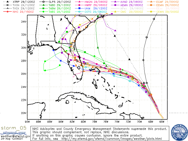
ATL: DORIAN - Models

Moderator: S2k Moderators

Message
Author
User avatar
SoupBone
Category 5
Category 5
Posts: 3111
Joined: Tue Sep 20, 2005 5:24 pm

Re: ATL: DORIAN - Models

#2661 Postby SoupBone » Thu Aug 29, 2019 11:11 am

tolakram wrote:
SoupBone wrote:The windshield wiper effect is very real. No one should be surprised. It'll probably swing back again next run. :lol:


I'm half expecting the euro to now start heading north. I hate the idea of a landfall but it will be best if the models come into better agreement so people can finalize plans and get the heck out of the way.


No doubt, living on the coast, we've all been there. I really hope that the GFS and Euro start some agreement as well.
0 likes   
Personal Forecast Disclaimer:
The posts in this forum are NOT official forecast and should not be used as such. They are just the opinion of the poster and may or may not be backed by sound meteorological data. They are NOT endorsed by any professional institution or storm2k.org. For official information, please refer to the NHC and NWS products.

beachman80

Re: ATL: DORIAN - Models

#2662 Postby beachman80 » Thu Aug 29, 2019 11:11 am

tolakram wrote:
SoupBone wrote:The windshield wiper effect is very real. No one should be surprised. It'll probably swing back again next run. :lol:


I'm half expecting the euro to now start heading north. I hate the idea of a landfall but it will be best if the models come into better agreement so people can finalize plans and get the heck out of the way.


Actually thinking the opposite. I think it may move south. It seems to have been moving along the same line of thjning as the UKMET which has stayed south.
0 likes   

User avatar
p1nheadlarry
Category 2
Category 2
Posts: 672
Age: 33
Joined: Wed Jan 29, 2014 2:42 pm
Location: SR County FL

Re: ATL: DORIAN - Models

#2663 Postby p1nheadlarry » Thu Aug 29, 2019 11:14 am

drewschmaltz wrote:I'm curious. The pressure drops to 981 by 30 hours on the 12Z GFS. Then it stays there and even raises 1mb over the next 18 hours - then continues lower somewhat rapidly. Is that mid-level dry air? Shear? ERC? I think a few expected Dorian to deepen over night. But, the comments about PR disrupting the feeder along with a little dry air was enough to hold him down. What do you think it is at hour 30 - 48 that keeps a lid on it?


Could be upper level shear, storm moves west but northeasterly steering
1 likes   
--;->#GoNoles--;->.

tolakram
Admin
Admin
Posts: 20017
Age: 62
Joined: Sun Aug 27, 2006 8:23 pm
Location: Florence, KY (name is Mark)

Re: ATL: DORIAN - Models

#2664 Postby tolakram » Thu Aug 29, 2019 11:14 am

Image
0 likes   
M a r k
- - - - -
Join us in chat: Storm2K Chatroom Invite. Android and IOS apps also available.

The posts in this forum are NOT official forecasts and should not be used as such. Posts are NOT endorsed by any professional institution or STORM2K.org. For official information and forecasts, please refer to NHC and NWS products.

beachman80

Re: ATL: DORIAN - Models

#2665 Postby beachman80 » Thu Aug 29, 2019 11:14 am

By the way, if you’re on the Fla west coast, I would not ignore this. The models would not have to tweak all that much for this to get into southeastern gulf, crawls bit and drift north or NNW. The ICON and NAVGEM very nearly do this. The Euro did this on Tuesday. The west coast is not out of the woods at all from a direct hit possibility or a scraping.
2 likes   

User avatar
AJC3
Admin
Admin
Posts: 4003
Age: 61
Joined: Tue Aug 31, 2004 7:04 pm
Location: Ballston Spa, New York
Contact:

Re: ATL: DORIAN - Models

#2666 Postby AJC3 » Thu Aug 29, 2019 11:15 am

On behalf of the board mods and admins, this is probably a good time to remind everyone that because of how hectic the next 3-4 days promise to be in here, try and remember to keep your posts and replies civil.

When someone posts an incorrect observation or piece of information, or an opinion that's ill-founded or has none at all, keep your emotions in check and politely correct them. When you disagree on an opinion, point out why, but in a civil manner.

It's fine to disagree, but (to quote Jules Winnfield) let's all try to be a bunch of little Fonzie's...and be cool about it. Think twice before you hit "submit" button.

Also, try and keep the chit chat posts of few words to a minimum. We've had to delete a number of one word WOW/OMG type posts over the past few days.

Finally, if you see a post that you feel violates board rules, report it, and one of the staff will address it.

*This is directed at noone in particular and everyone in general. Thanks. Carry on, stay safe, and let's sit back and see how the next few days evolve. It should be a wild ride.
18 likes   

User avatar
eastcoastFL
Category 5
Category 5
Posts: 3901
Age: 43
Joined: Thu Apr 12, 2007 12:29 pm
Location: Palm City, FL

Re: ATL: DORIAN - Models

#2667 Postby eastcoastFL » Thu Aug 29, 2019 11:16 am

StPeteMike wrote:
hurricaneCW wrote:
StPeteMike wrote:Not Aric, but that’s what my feeling was with the 6z models. Recurve is still a good possibility, but the timing (especially but unfortunately) of it happening before Florida was off, too slow of speed.


There's no sweeping trough to recurve this thing. It'll likely just get stuck and wait for the ridge to rebuild. Worst case scenario is that he gets stuck just inland.

This is true, but there’s the possibility that with the weak steering currents, a slow direction to the north or northwest could occur.

I think the models showing a SW to WSW movement are picking up the weak steering currents and the chance the storm could just meander around for a while before something let’s up.


I agree. I think its just going to drift around for a bit until something pulls it north or pushes it north east.
1 likes   
Personal Forecast Disclaimer:
The posts in this forum are NOT official forecast and should not be used as such. They are just the opinion of the poster and may or may not be backed by sound meteorological data. They are NOT endorsed by any professional institution or storm2k.org. For official information, please refer to the NHC and NWS products.

User avatar
GCANE
S2K Supporter
S2K Supporter
Posts: 11509
Joined: Mon Oct 22, 2007 8:03 am

ATL: DORIAN - Hurricane - Discussion

#2668 Postby GCANE » Thu Aug 29, 2019 11:17 am

0 likes   

User avatar
cjrciadt
S2K Supporter
S2K Supporter
Posts: 1616
Joined: Mon Aug 22, 2005 1:11 pm
Location: Kissimmee, FL

Re: ATL: DORIAN - Models

#2669 Postby cjrciadt » Thu Aug 29, 2019 11:18 am


This could give me CAT 1-3 gusts for almost an entire day!! :oops: :double:
Charley was in and out as aCat 1 in under 2 hrs!
0 likes   

User avatar
GCANE
S2K Supporter
S2K Supporter
Posts: 11509
Joined: Mon Oct 22, 2007 8:03 am

ATL: DORIAN - Hurricane - Discussion

#2670 Postby GCANE » Thu Aug 29, 2019 11:22 am

0 likes   

jhpigott
Category 2
Category 2
Posts: 570
Joined: Wed Jan 02, 2008 8:09 pm
Location: North Palm Beach, Florida

Re: ATL: DORIAN - Models

#2671 Postby jhpigott » Thu Aug 29, 2019 11:23 am

I would think if the Euro were to hold serve at 12z (landfall at WPB or points south) and with the GFS 12z making landfall in the Vero/Melbourne vicinity, the NHC may adjust their landfall point at the 5pm update south to somewhere along the Martin County/St. Lucie County coastline.
0 likes   

beachman80

Re: ATL: DORIAN - Models

#2672 Postby beachman80 » Thu Aug 29, 2019 11:24 am

CMC on board with stalling. Stalls it in Jupiter and just sits there and then drifts NW into central part of state.

https://www.tropicaltidbits.com/analysi ... 2900&fh=48
0 likes   

seahawkjd
S2K Supporter
S2K Supporter
Posts: 632
Joined: Wed Sep 10, 2003 4:12 pm
Location: Morehead City, NC
Contact:

Re: ATL: DORIAN - Models

#2673 Postby seahawkjd » Thu Aug 29, 2019 11:24 am

Anyone still watching the GFS? It drops the storm south at 168 dropping the storm south and then back off shore.
0 likes   
Gloria, Hugo, Emily, Bertha, Bonnie, Dennis (twice), Fran, Floyd, Isabel, Irene, Arthur, Matthew, Florence, Dorian (and many tropical storms and nor'easters).

User avatar
cycloneye
Admin
Admin
Posts: 145813
Age: 68
Joined: Thu Oct 10, 2002 10:54 am
Location: San Juan, Puerto Rico

Re: ATL: DORIAN - Hurricane - Discussion

#2674 Postby cycloneye » Thu Aug 29, 2019 11:24 am


Moved this post from the discussion thread to here.
0 likes   
Visit the Caribbean-Central America Weather Thread where you can find at first post web cams,radars
and observations from Caribbean basin members Click Here

TheStormExpert

Re: ATL: DORIAN - Hurricane - Discussion

#2675 Postby TheStormExpert » Thu Aug 29, 2019 11:24 am

0 likes   

plasticup

Re: ATL: DORIAN - Models

#2676 Postby plasticup » Thu Aug 29, 2019 11:25 am

cjrciadt wrote:

This could give me CAT 1-3 gusts for almost an entire day!! :oops: :double:
Charley was in and out as aCat 1 in under 2 hrs!

With Fabian, we had TS winds for 36 hours, Cat 1 for 24 hours, and Cat 4 peak. The damage was unlike anything I've ever seen. I had never appreciate that the duration of wind makes such a difference.
1 likes   

User avatar
SEASON_CANCELED
Category 3
Category 3
Posts: 887
Joined: Mon Jul 06, 2009 5:17 am
Location: 8 Bit Charlie Sheen

Re: ATL: DORIAN - Models

#2677 Postby SEASON_CANCELED » Thu Aug 29, 2019 11:25 am

Gettin real over in tampa. Gas and water shortages starting. People starting to panic at work with this latest update. It may slice across florida and linger over tampa flbefore headong north.
3 likes   
i am a big stupid ugly moron with an ugly face and a big butt and my butt stinks and i like to kiss my own butt

sma10
Category 5
Category 5
Posts: 1710
Joined: Tue Aug 02, 2005 1:13 pm

Re: ATL: DORIAN - Models

#2678 Postby sma10 » Thu Aug 29, 2019 11:26 am

Subtle, but note that the Uk has dropped its WSW dip
1 likes   

supercane4867
Category 5
Category 5
Posts: 4966
Joined: Wed Nov 14, 2012 10:43 am

Re: ATL: DORIAN - Models

#2679 Postby supercane4867 » Thu Aug 29, 2019 11:27 am

12z UKMET is the blue track that takes Dorian into GOM

Image
0 likes   

User avatar
northjaxpro
S2K Supporter
S2K Supporter
Posts: 8900
Joined: Mon Sep 27, 2010 11:21 am
Location: Jacksonville, FL

Re: ATL: DORIAN - Models

#2680 Postby northjaxpro » Thu Aug 29, 2019 11:27 am

Wow GFS projecting.more than 2 feet of rain potential along Dorian's potential path up and along the Florida East Coast

This simply would be flat out catastrophic , but with a very slow moving or even stalled powerful hurricane, these rain totals are definitely possible.or even greater.
Last edited by northjaxpro on Thu Aug 29, 2019 11:31 am, edited 1 time in total.
1 likes   
NEVER, EVER SAY NEVER in the tropics and weather in general, and most importantly, with life itself!!

________________________________________________________________________________________

Fay 2008 Beryl 2012 Debby 2012 Colin 2016 Hermine 2016 Julia 2016 Matthew 2016 Irma 2017 Dorian 2019


Return to “2019”

Who is online

Users browsing this forum: No registered users and 6 guests