https://twitter.com/DTVaWeatherman/status/1167169829805133826
ATL: DORIAN - Models
Moderator: S2k Moderators
-
SFLcane

- S2K Supporter

- Posts: 10281
- Age: 48
- Joined: Sat Jun 05, 2010 1:44 pm
- Location: Lake Worth Florida
Re: ATL: DORIAN - Models
4 likes


Re: ATL: DORIAN - Models
Blinhart wrote:If I remember at one time Katrina was suppose to go up to Pensacola and ended up in New Orleans.
Yup, I remember that, too.
2 likes
Storm Track: Erin '95, Opal '95, Danny '97, Georges '98, Ivan '04, Dennis '05
Re: ATL: DORIAN - Models
If I would have to answer that question, I would say the likelihood is very low of a sharp turn like that happening. I think it would take more like 36 hours not 18 hours.
0 likes
Personal Forecast Disclaimer:
The posts in this forum are NOT official forecast and should not be used as such. They are just the opinion of the poster and may or may not be backed by sound meteorological data. They are NOT endorsed by any professional institution or storm2k.org. For official information, please refer to the NHC and NWS products.
The posts in this forum are NOT official forecast and should not be used as such. They are just the opinion of the poster and may or may not be backed by sound meteorological data. They are NOT endorsed by any professional institution or storm2k.org. For official information, please refer to the NHC and NWS products.
-
toad strangler

- S2K Supporter
- Posts: 4546
- Joined: Sun Jul 28, 2013 3:09 pm
- Location: Earth
- Contact:
-
Aric Dunn
- Category 5

- Posts: 21238
- Age: 43
- Joined: Sun Sep 19, 2004 9:58 pm
- Location: Ready for the Chase.
- Contact:
Re: ATL: DORIAN - Models
THe biggest thing we have to watch is that upper low. this bend to the west can just as easily start sooner depending on haw far sw that low moves.
2 likes
Note: If I make a post that is brief. Please refer back to previous posts for the analysis or reasoning. I do not re-write/qoute what my initial post said each time.
If there is nothing before... then just ask
Space & Atmospheric Physicist, Embry-Riddle Aeronautical University,
I believe the sky is falling...
If there is nothing before... then just ask
Space & Atmospheric Physicist, Embry-Riddle Aeronautical University,
I believe the sky is falling...
-
AtlanticWind

- S2K Supporter
- Posts: 1898
- Age: 67
- Joined: Sun Aug 08, 2004 9:57 pm
- Location: Plantation,Fla
Re: ATL: DORIAN - Models
alienstorm wrote:12Z EPS - Average track OTS
https://imagizer.imageshack.com/img923/3221/PoDnj1.jpg
I wouldn't go by the average ,as it has several members peeling north way to soon
That's not going to happen
2 likes
Re: ATL: DORIAN - Models
ronjon wrote:Miami Storm Tracker wrote:Been out of the office most of the day,
Attempting to catch on on what models has done what. But to be honest with you right now after reading these post I am so confused. Is it staying of shore now is it north East west south Lol what happened today with the models.
I posted this on the other thread.
To see how much the 12z Euro is an outlier, here's travel times for landfalls from today's 12z model suite. The average landfall time from the nine other models not named Euro is 100 hrs.
GFS - 99 hrs (Vero Beach)
GFS Legacy - 99 hrs (Jupiter)
CMC - 117 hrs (Jupiter)
NAVGEM - 108 hrs (WPB)
ICON - 108 hrs (Ft Laud)
HWRF - 96 hrs (Melbourne)
HMON - 102 hrs (Miami)
NAM - 84 hrs (WPB)
UKMET - 84 hrs (WPB)
Euro - 144 hrs (WPB)
That is really eye opening. We should track this over the next 24 hours model runs and see if the group moves towards euro or euro towards the group
1 likes
-
TheStormExpert
Re: ATL: DORIAN - Models
ronjon wrote:Miami Storm Tracker wrote:Been out of the office most of the day,
Attempting to catch on on what models has done what. But to be honest with you right now after reading these post I am so confused. Is it staying of shore now is it north East west south Lol what happened today with the models.
I posted this on the other thread.
To see how much the 12z Euro is an outlier, here's travel times for landfalls from today's 12z model suite. The average landfall time from the nine other models not named Euro is 100 hrs.
GFS - 99 hrs (Vero Beach)
GFS Legacy - 99 hrs (Jupiter)
CMC - 117 hrs (Jupiter)
NAVGEM - 108 hrs (WPB)
ICON - 108 hrs (Ft Laud)
HWRF - 96 hrs (Melbourne)
HMON - 102 hrs (Miami)
NAM - 84 hrs (WPB)
UKMET - 84 hrs (WPB)
Euro - 144 hrs (WPB)
12z GFS-Legacy doesn’t have a landfall in Jupiter, it’s more like Ft. Pierce.
0 likes
-
beachman80
Re: ATL: DORIAN - Models
ronjon wrote:Miami Storm Tracker wrote:Been out of the office most of the day,
Attempting to catch on on what models has done what. But to be honest with you right now after reading these post I am so confused. Is it staying of shore now is it north East west south Lol what happened today with the models.
I posted this on the other thread.
To see how much the 12z Euro is an outlier, here's travel times for landfalls from today's 12z model suite. The average landfall time from the nine other models not named Euro is 100 hrs.
GFS - 99 hrs (Vero Beach)
GFS Legacy - 99 hrs (Jupiter)
CMC - 117 hrs (Jupiter)
NAVGEM - 108 hrs (WPB)
ICON - 108 hrs (Ft Laud)
HWRF - 96 hrs (Melbourne)
HMON - 102 hrs (Miami)
NAM - 84 hrs (WPB)
UKMET - 84 hrs (WPB)
Euro - 144 hrs (WPB)
Interesting. UK and Euro have been on the same page with this storm until the 12z. They were literally like twins in how they saw the storm. Now they've gone in completely different directions. UK with landfall in 84 hours and going into the Gulf. Euro with landfall in 144 hours and going N and then NE. To me, those are the best two models and I'm curious which will blink first.
1 likes
-
gatorcane

- S2K Supporter
- Posts: 23708
- Age: 48
- Joined: Sun Mar 13, 2005 3:54 pm
- Location: Boca Raton, FL
Re: ATL: DORIAN - Models
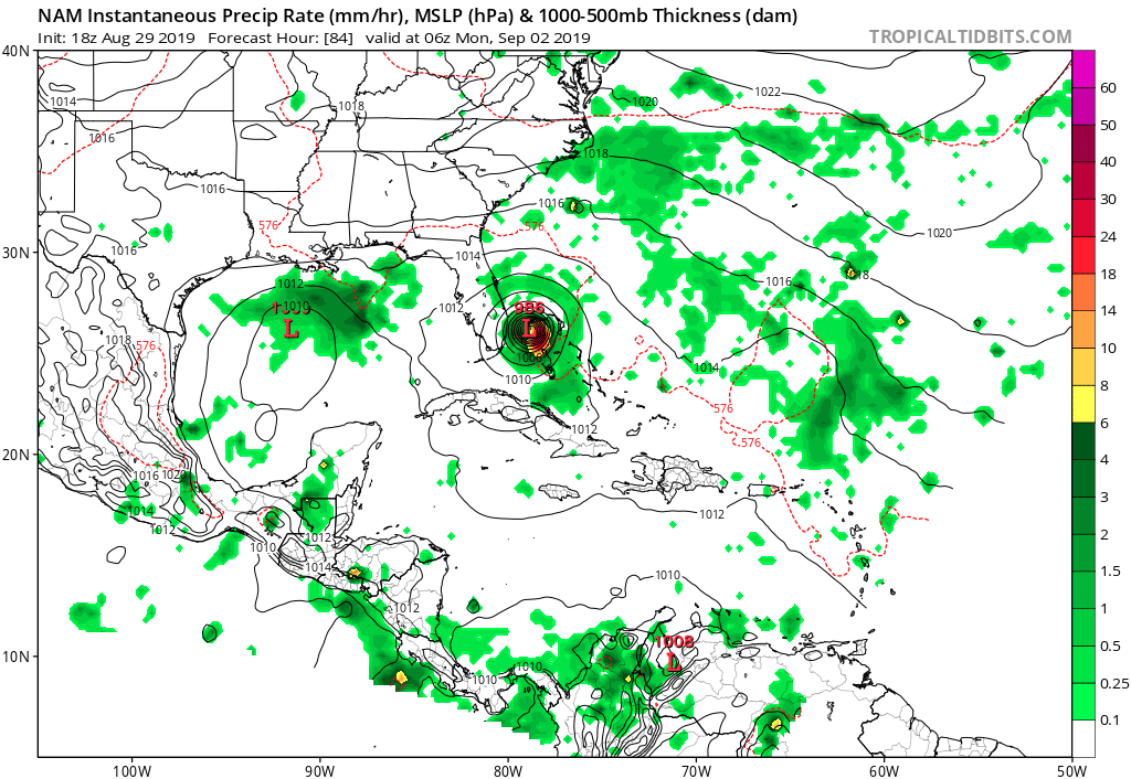
18Z NAM Bee-lines towards SE Florida and even has a WSW dip. 
Last edited by gatorcane on Thu Aug 29, 2019 3:39 pm, edited 1 time in total.
2 likes
-
CalmBeforeStorm

- Category 2

- Posts: 600
- Age: 72
- Joined: Tue Aug 10, 2004 7:55 pm
- Location: Stuart, Florida
Re: ATL: DORIAN - Models
Bhuggs wrote:ronjon wrote:Miami Storm Tracker wrote:Been out of the office most of the day,
Attempting to catch on on what models has done what. But to be honest with you right now after reading these post I am so confused. Is it staying of shore now is it north East west south Lol what happened today with the models.
I posted this on the other thread.
To see how much the 12z Euro is an outlier, here's travel times for landfalls from today's 12z model suite. The average landfall time from the nine other models not named Euro is 100 hrs.
GFS - 99 hrs (Vero Beach)
GFS Legacy - 99 hrs (Jupiter)
CMC - 117 hrs (Jupiter)
NAVGEM - 108 hrs (WPB)
ICON - 108 hrs (Ft Laud)
HWRF - 96 hrs (Melbourne)
HMON - 102 hrs (Miami)
NAM - 84 hrs (WPB)
UKMET - 84 hrs (WPB)
Euro - 144 hrs (WPB)
That is really eye opening. We should track this over the next 24 hours model runs and see if the group moves towards euro or euro towards the group
This is misleading. Almost all of the models show some sort of stall or slowdown and some degree of a northern turn. The Euro is showing this slowdown further east rather than already over Florida thus the wider gap in time before landfall. The significant feature is the more eastern stall.
0 likes
-
CourierPR

- Category 5
- Posts: 1336
- Age: 72
- Joined: Tue Aug 31, 2004 7:53 pm
- Location: Pompano Beach, Florida
Re: ATL: DORIAN - Models
I think, as Aric previously alluded to, that much will depend on when that bend to the west happens. If it happens earlier than forecasted then things will get very interesting.
1 likes

Re: ATL: DORIAN - Models
gatorcane wrote:18Z NAM Bee-lines towards SE Florida and even has a WSW dip.
Yeah still very similar to the UKMET - either Dorian rides the ridge and accelerates or slows to a crawl with it collapsing.
1 likes
Re: ATL: DORIAN - Models
gatorcane wrote:18Z NAM Bee-lines towards SE Florida and even has a WSW dip.
NAM is useless in tropical forecasting
0 likes
-
p1nheadlarry

- Category 2
- Posts: 672
- Age: 34
- Joined: Wed Jan 29, 2014 2:42 pm
- Location: SR County FL
Re: ATL: DORIAN - Models
Blinhart wrote:The major problem with all these models is that they are all suggesting a trough that isn't even around right now. No idea how strong or how far it will move and the impact it will have on the actual movement and weaknesses in the future. So everything is up in the air. Many meteorologists are still trying to get a grasp of the possible effects of this trough and what is going to happen. So everything should be taken with a grain of salt.
Shortwaves are potent little suckers. It's the curvature!
0 likes
--;->#GoNoles--;->.

Re: ATL: DORIAN - Models
storm4u wrote:gatorcane wrote:18Z NAM Bee-lines towards SE Florida and even has a WSW dip.
NAM is useless in tropical forecasting
I could say the same for ICON track wise, yet people still include it as a reference
0 likes
Re: ATL: DORIAN - Models
CalmBeforeStorm wrote:Bhuggs wrote:ronjon wrote:
I posted this on the other thread.
To see how much the 12z Euro is an outlier, here's travel times for landfalls from today's 12z model suite. The average landfall time from the nine other models not named Euro is 100 hrs.
GFS - 99 hrs (Vero Beach)
GFS Legacy - 99 hrs (Jupiter)
CMC - 117 hrs (Jupiter)
NAVGEM - 108 hrs (WPB)
ICON - 108 hrs (Ft Laud)
HWRF - 96 hrs (Melbourne)
HMON - 102 hrs (Miami)
NAM - 84 hrs (WPB)
UKMET - 84 hrs (WPB)
Euro - 144 hrs (WPB)
That is really eye opening. We should track this over the next 24 hours model runs and see if the group moves towards euro or euro towards the group
This is misleading. Almost all of the models show some sort of stall or slowdown and some degree of a northern turn. The Euro is showing this slowdown further east rather than already over Florida thus the wider gap in time before landfall. The significant feature is the more eastern stall.
I disagree. Euro still has Dorian out near the eastern Bahama islands at 96 hrs.
Take a look.
https://www.tropicaltidbits.com/analysis/models/?model=ecmwf®ion=seus&pkg=mslp_uv850&runtime=2019082912&fh=96
1 likes


Re: ATL: DORIAN - Models
DT is a good met, his best statement on FaceBook:
"However given that it still late Summer and just turning into early Autumn it is quite possible that the weather models are overdoing the depth of this trough. They often do that in the extended range. If that is the case we should know in a subsequent weather models over the next 36 hours and we may see less of a turn to the northwest and increased chance of Dorian getting into the eastern Gulf of Mexico."
Yup, happens consistently at this time of year
2 likes
Who is online
Users browsing this forum: No registered users and 19 guests