ATL: KAREN - Models
Moderator: S2k Moderators
-
gatorcane

- S2K Supporter

- Posts: 23708
- Age: 48
- Joined: Sun Mar 13, 2005 3:54 pm
- Location: Boca Raton, FL
Re: ATL: INVEST 99L - Models
Moving NE slowly at 240 but it’s a close call and that is a long time from now.
Last edited by gatorcane on Sat Sep 21, 2019 1:59 pm, edited 1 time in total.
0 likes
-
GeneratorPower

- S2K Supporter
- Posts: 1648
- Age: 46
- Joined: Sun Dec 18, 2005 11:48 pm
- Location: Huntsville, AL
Re: ATL: INVEST 99L - Models
GFS ended up taking the weak system in the same overall direction with a SW dip then over Cuba then landfall NGOM
0 likes
-
GeneratorPower
- S2K Supporter
- Posts: 1648
- Age: 46
- Joined: Sun Dec 18, 2005 11:48 pm
- Location: Huntsville, AL
Re: ATL: INVEST 99L - Models
gatorcane wrote:Moving NE slowly at 240 but it’s a close call and that is a long time from now.
And this run is a big change from last run. Ridge placements are totally whack but oddly storm behavior matches GFS. I’d say we have a definite case of new data being invested into models causing a flip flop.
0 likes
Re: ATL: INVEST 99L - Models
Early days, but things are interesting with 99L.
Would like to see 12z EPS - I imagine there are a lot of wild long range solutions
Would like to see 12z EPS - I imagine there are a lot of wild long range solutions
1 likes
-
Emmett_Brown

- Category 5

- Posts: 1433
- Joined: Wed Aug 24, 2005 9:10 pm
- Location: Sarasota FL
Re: ATL: INVEST 99L - Models
The unusual pattern continues... the troughs that turn storms are not so much those coming down through the midwest, but more so those nosing in through the back door from the N Atlantic/Flemish Cap area, drawing storms up and out. Looks like this might be the case with the 12z Euro if you extended this run past 240 hours.
1 likes
-
crownweather

- S2K Supporter
- Posts: 602
- Age: 51
- Joined: Sat Aug 12, 2006 9:21 am
- Location: Sturbridge, Massachusetts
- Contact:
Re: ATL: INVEST 99L - Models
The reason for the changes in the guidance with 99L has to do with the weakening of Jerry. Previously, the model guidance left a big enough weakness from Jerry to pull 99L northward and keep it weak due to outflow created shear.
Now, the guidance seems to be catching on to the fact that Jerry may not be all that strong. This leads to less shear and a much weaker weakness. Now, the question is whether the ridge may be stronger in future runs and whether Jerry will leave behind any weakness at all.
Now, the guidance seems to be catching on to the fact that Jerry may not be all that strong. This leads to less shear and a much weaker weakness. Now, the question is whether the ridge may be stronger in future runs and whether Jerry will leave behind any weakness at all.
3 likes
Rob Lightbown
Crown Weather Services
https://crownweather.com
Crown Weather Services
https://crownweather.com
-
GeneratorPower
- S2K Supporter
- Posts: 1648
- Age: 46
- Joined: Sun Dec 18, 2005 11:48 pm
- Location: Huntsville, AL

-
Hurricaneman

- Category 5
- Posts: 7404
- Age: 45
- Joined: Tue Aug 31, 2004 3:24 pm
- Location: central florida
Re: ATL: INVEST 99L - Models
This will probably end up a fork in the road situation like if the trough isn’t as deep as on the Euro it goes west into south Florida or northern Cuba and into the GOM but if vice versa then this will be heading out to sea after the Lesser Antilles
1 likes
-
TheStormExpert
Re: ATL: INVEST 99L - Models
Hurricaneman wrote:This will probably end up a fork in the road situation like if the trough isn’t as deep as on the Euro it goes west into south Florida or northern Cuba and into the GOM but if vice versa then this will be heading out to sea after the Lesser Antilles
Really GoM? Unless a significant sprawling ridge develops to its north and east I just don’t see that happening. Even Florida seems far from being hit on this recent Euro run.
0 likes
-
GeneratorPower
- S2K Supporter
- Posts: 1648
- Age: 46
- Joined: Sun Dec 18, 2005 11:48 pm
- Location: Huntsville, AL
Re: ATL: INVEST 99L - Models
TheStormExpert wrote:Hurricaneman wrote:This will probably end up a fork in the road situation like if the trough isn’t as deep as on the Euro it goes west into south Florida or northern Cuba and into the GOM but if vice versa then this will be heading out to sea after the Lesser Antilles
Really GoM? Unless a significant sprawling ridge develops to its north and east I just don’t see that happening. Even Florida seems far from being hit on this recent Euro run.
Trending that direction. See a couple posts up where I put the trend GIF
0 likes
-
gatorcane
- S2K Supporter
- Posts: 23708
- Age: 48
- Joined: Sun Mar 13, 2005 3:54 pm
- Location: Boca Raton, FL
Re: ATL: INVEST 99L - Models
A lot of strong CMC ensembles turn this west north of Puerto Rico and beeline towards the Bahamas and South Florida / FL Straits

0 likes
-
GeneratorPower
- S2K Supporter
- Posts: 1648
- Age: 46
- Joined: Sun Dec 18, 2005 11:48 pm
- Location: Huntsville, AL
-
Emmett_Brown
- Category 5
- Posts: 1433
- Joined: Wed Aug 24, 2005 9:10 pm
- Location: Sarasota FL
Re: ATL: INVEST 99L - Models
Euro Ensembles: https://www.weathernerds.org/tc_guidanc ... ?tcid=AL99
1 likes
Re: ATL: INVEST 99L - Models
Emmett_Brown wrote:Euro Ensembles: https://www.weathernerds.org/tc_guidanc ... ?tcid=AL99
12Z EPS: confusing because some of these US hits from Jerry & others from 99L
0 likes
Personal Forecast Disclaimer:
The posts in this forum are NOT official forecasts and should not be used as such. They are just the opinion of the poster and may or may not be backed by sound meteorological data. They are NOT endorsed by any professional institution or storm2k.org. For official information, please refer to the NHC and NWS products.
The posts in this forum are NOT official forecasts and should not be used as such. They are just the opinion of the poster and may or may not be backed by sound meteorological data. They are NOT endorsed by any professional institution or storm2k.org. For official information, please refer to the NHC and NWS products.
Re: ATL: INVEST 99L - Models
LarryWx wrote:Emmett_Brown wrote:Euro Ensembles: https://www.weathernerds.org/tc_guidanc ... ?tcid=AL99
12Z EPS: confusing because some of these US hits from Jerry & others from 99L
EPS for 99L looks exactly as I expected: chaotic. Barring a simple fast track East of PR and quickly out to sea, this looks like an interesting next few days as there is a chance of 99L to pull off a very anomolous track
0 likes
-
gatorcane
- S2K Supporter
- Posts: 23708
- Age: 48
- Joined: Sun Mar 13, 2005 3:54 pm
- Location: Boca Raton, FL
Re: ATL: INVEST 99L - Models
gatorcane wrote:A lot of strong CMC ensembles turn this west north of Puerto Rico and beeline towards the Bahamas and South Florida / FL Straits
https://i.postimg.cc/pTMmfCDZ/gem-ememb-lowlocs-watl-35.png
Another look at the 12Z CMC ensembles FWIW:
2 likes

Re: ATL: INVEST 99L - Models
gatorcane wrote:gatorcane wrote:A lot of strong CMC ensembles turn this west north of Puerto Rico and beeline towards the Bahamas and South Florida / FL Straits
https://i.postimg.cc/pTMmfCDZ/gem-ememb-lowlocs-watl-35.png
Another look at the 12Z CMC ensembles FWIW:
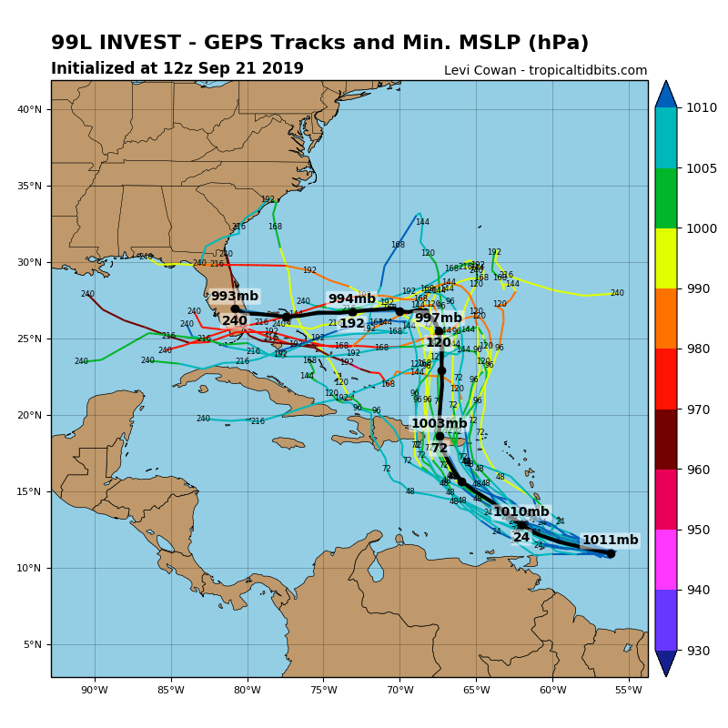
https://i.postimg.cc/25chRMBS/99-L-geps-12z.png
It's still way too early to say at this point (the storm hasn't even formed yet), but I hope the future ensembles won't look like this one. The (I think average) bolded line even goes directly over the Bahamas
Last edited by kevin on Sat Sep 21, 2019 4:54 pm, edited 1 time in total.
0 likes
-
plasticup
Re: ATL: INVEST 99L - Models
Hurricaneman wrote:This will probably end up a fork in the road situation like if the trough isn’t as deep as on the Euro it goes west into south Florida or northern Cuba and into the GOM but if vice versa then this will be heading out to sea after the Lesser Antilles
Just to clarify, “out to sea” in this case means Bermuda’s third hurricane in two weeks.
1 likes
-
cycloneye

- Admin

- Posts: 149275
- Age: 69
- Joined: Thu Oct 10, 2002 10:54 am
- Location: San Juan, Puerto Rico
Re: ATL: INVEST 99L - Models
18z GFS wants to do the same as Euro north of the Greater Antilles.

0 likes
Visit the Caribbean-Central America Weather Thread where you can find at first post web cams,radars
and observations from Caribbean basin members Click Here
and observations from Caribbean basin members Click Here
Re: ATL: INVEST 99L - Models
cycloneye wrote:18z GFS wants to do the same as Euro north of the Greater Antilles.
https://i.imgur.com/aw6ylwN.gif
Yep. And with an even more ominous upper level setup
1 likes
Who is online
Users browsing this forum: No registered users and 48 guests