
WPAC: KAMMURI - Post-Tropical
Moderator: S2k Moderators
-
mrbagyo

- Category 5

- Posts: 3963
- Age: 33
- Joined: Thu Apr 12, 2012 9:18 am
- Location: 14.13N 120.98E
- Contact:
Re: WPAC: KAMMURI - Typhoon
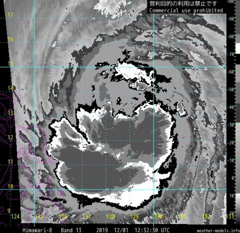
The eye is starting to clear out
0 likes
The posts in this forum are NOT official forecast and should not be used as such. They are just the opinion of the poster and may or may not be backed by sound meteorological data. They are NOT endorsed by any professional institution or storm2k.org. For official information, please refer to RSMC, NHC and NWS products.

Re: WPAC: KAMMURI - Typhoon
Dvorak looked better 40 mins ago than now


0 likes
ヤンデレ女が寝取られるているのを見たい!!!
ECMWF ensemble NWPAC plots: https://ecmwfensnwpac.imgbb.com/
Multimodel NWPAC plots: https://multimodelnwpac.imgbb.com/
GFS Ensemble NWPAC plots (16 & 35 day forecast): https://gefsnwpac.imgbb.com/
Plots updated automatically
ECMWF ensemble NWPAC plots: https://ecmwfensnwpac.imgbb.com/
Multimodel NWPAC plots: https://multimodelnwpac.imgbb.com/
GFS Ensemble NWPAC plots (16 & 35 day forecast): https://gefsnwpac.imgbb.com/
Plots updated automatically

Re: WPAC: KAMMURI - Typhoon
0 likes
Very useful information on the Dvorak Technique --
https://severe.worldweather.wmo.int/TCF ... kBeven.pdf
https://severe.worldweather.wmo.int/TCF ... kBeven.pdf
Re: WPAC: KAMMURI - Typhoon
Almost STY

0 likes
ヤンデレ女が寝取られるているのを見たい!!!
ECMWF ensemble NWPAC plots: https://ecmwfensnwpac.imgbb.com/
Multimodel NWPAC plots: https://multimodelnwpac.imgbb.com/
GFS Ensemble NWPAC plots (16 & 35 day forecast): https://gefsnwpac.imgbb.com/
Plots updated automatically
ECMWF ensemble NWPAC plots: https://ecmwfensnwpac.imgbb.com/
Multimodel NWPAC plots: https://multimodelnwpac.imgbb.com/
GFS Ensemble NWPAC plots (16 & 35 day forecast): https://gefsnwpac.imgbb.com/
Plots updated automatically

Re: WPAC: KAMMURI - Typhoon
Hayabusa wrote:Dvorak looked better 40 mins ago than now
https://i.imgur.com/w3cWzdB.png
https://i.imgur.com/vZQhwTY.png
Maybe a smaller eye is trying to form.
0 likes
Irene '11 Sandy '12 Hermine '16 5/15/2018 Derecho Fay '20 Isaias '20 Elsa '21 Henri '21 Ida '21
I am only a meteorology enthusiast who knows a decent amount about tropical cyclones. Look to the professional mets, the NHC, or your local weather office for the best information.
I am only a meteorology enthusiast who knows a decent amount about tropical cyclones. Look to the professional mets, the NHC, or your local weather office for the best information.
Re: WPAC: KAMMURI - Typhoon
Down to 75 and peak is now even more weaker, yesterday at 03Z and 12Z it's 925 mb and 935 mb respectively.
TY 1928 (Kammuri)
Issued at 12:50 UTC, 1 December 2019
<Analysis at 12 UTC, 1 December>
Scale -
Intensity -
Center position N13°05' (13.1°)
E129°10' (129.2°)
Direction and speed of movement W 20 km/h (12 kt)
Central pressure 965 hPa
Maximum wind speed near center 40 m/s (75 kt)
Maximum wind gust speed 55 m/s (105 kt)
≥ 50 kt wind area ALL 110 km (60 NM)
≥ 30 kt wind area NW 500 km (270 NM)
SE 280 km (150 NM)
<Forecast for 00 UTC, 2 December>
Intensity -
Center position of probability circle N13°30' (13.5°)
E127°10' (127.2°)
Direction and speed of movement W 20 km/h (10 kt)
Central pressure 955 hPa
Maximum wind speed near center 40 m/s (80 kt)
Maximum wind gust speed 60 m/s (115 kt)
Radius of probability circle 40 km (20 NM)
Storm warning area ALL 150 km (80 NM)
<Forecast for 12 UTC, 2 December>
Intensity Very strong
Center position of probability circle N13°55' (13.9°)
E125°05' (125.1°)
Direction and speed of movement W 20 km/h (10 kt)
Central pressure 950 hPa
Maximum wind speed near center 45 m/s (85 kt)
Maximum wind gust speed 60 m/s (120 kt)
Radius of probability circle 60 km (30 NM)
Storm warning area ALL 170 km (90 NM)
<Forecast for 12 UTC, 3 December>
Intensity -
Center position of probability circle N14°05' (14.1°)
E120°30' (120.5°)
Direction and speed of movement W 20 km/h (11 kt)
Central pressure 980 hPa
Maximum wind speed near center 30 m/s (60 kt)
Maximum wind gust speed 45 m/s (85 kt)
Radius of probability circle 110 km (60 NM)
Storm warning area ALL 190 km (100 NM)
<Forecast for 12 UTC, 4 December>
Intensity -
Center position of probability circle N15°05' (15.1°)
E116°35' (116.6°)
Direction and speed of movement WNW 20 km/h (10 kt)
Central pressure 990 hPa
Maximum wind speed near center 25 m/s (50 kt)
Maximum wind gust speed 35 m/s (70 kt)
Radius of probability circle 190 km (100 NM)
<Forecast for 12 UTC, 5 December>
Intensity -
Center position of probability circle N13°35' (13.6°)
E114°30' (114.5°)
Direction and speed of movement SW 10 km/h (6 kt)
Central pressure 1002 hPa
Maximum wind speed near center 18 m/s (35 kt)
Maximum wind gust speed 25 m/s (50 kt)
Radius of probability circle 260 km (140 NM)
<Forecast for 12 UTC, 6 December>
Intensity -
TD
Center position of probability circle N8°40' (8.7°)
E113°10' (113.2°)
Direction and speed of movement S 25 km/h (13 kt)
Central pressure 1008 hPa
Radius of probability circle 370 km (200 NM)
0 likes
ヤンデレ女が寝取られるているのを見たい!!!
ECMWF ensemble NWPAC plots: https://ecmwfensnwpac.imgbb.com/
Multimodel NWPAC plots: https://multimodelnwpac.imgbb.com/
GFS Ensemble NWPAC plots (16 & 35 day forecast): https://gefsnwpac.imgbb.com/
Plots updated automatically
ECMWF ensemble NWPAC plots: https://ecmwfensnwpac.imgbb.com/
Multimodel NWPAC plots: https://multimodelnwpac.imgbb.com/
GFS Ensemble NWPAC plots (16 & 35 day forecast): https://gefsnwpac.imgbb.com/
Plots updated automatically
Re: WPAC: KAMMURI - Typhoon

0 likes
Very useful information on the Dvorak Technique --
https://severe.worldweather.wmo.int/TCF ... kBeven.pdf
https://severe.worldweather.wmo.int/TCF ... kBeven.pdf
-
1900hurricane

- Category 5
- Posts: 6063
- Age: 34
- Joined: Fri Feb 06, 2015 12:04 pm
- Location: Houston, TX
- Contact:
Re: WPAC: KAMMURI - Typhoon
0 likes
Contract Meteorologist. TAMU & MSST. Fiercely authentic, one of a kind. We are all given free will, so choose a life meant to be lived. We are the Masters of our own Stories.
Opinions expressed are mine alone.
Follow me on Twitter at @1900hurricane : Read blogs at https://1900hurricane.wordpress.com/
Opinions expressed are mine alone.
Follow me on Twitter at @1900hurricane : Read blogs at https://1900hurricane.wordpress.com/
Re: WPAC: KAMMURI - Typhoon
Same observation as above in Dvorak
0 likes
Very useful information on the Dvorak Technique --
https://severe.worldweather.wmo.int/TCF ... kBeven.pdf
https://severe.worldweather.wmo.int/TCF ... kBeven.pdf

Re: WPAC: KAMMURI - Typhoon
It seems to be doing its last hurrah before landfall. And I'm in the path of the thing 
0 likes
The above post is not official and should not be used as such. It is the opinion of the poster and may or may not be backed by sound meteorological data. It is not endorsed by any professional institution or storm2k.org. For official information, please refer to the NHC and NWS products.
Re: WPAC: KAMMURI - Typhoon
One more band for documentation purposes:
https://twitter.com/JamesMclaire/status/1201151286202126336
https://twitter.com/JamesMclaire/status/1201151286202126336
0 likes
Very useful information on the Dvorak Technique --
https://severe.worldweather.wmo.int/TCF ... kBeven.pdf
https://severe.worldweather.wmo.int/TCF ... kBeven.pdf
Re: WPAC: KAMMURI - Typhoon
Off white eye embedded in Light grey, and subtracting .5 for elongation would yield about a T 4.5 from what i can see
0 likes
Very useful information on the Dvorak Technique --
https://severe.worldweather.wmo.int/TCF ... kBeven.pdf
https://severe.worldweather.wmo.int/TCF ... kBeven.pdf
Re: WPAC: KAMMURI - Typhoon
That’s some very deep convection surrounding the forming eye/eyewall. I have a feeling raw Ts are going to skyrocket once it closes off and starts clearing.
Update: it’s already happening. Raw T as of 14:30 UTC is T#6.5
Update: it’s already happening. Raw T as of 14:30 UTC is T#6.5
0 likes
Irene '11 Sandy '12 Hermine '16 5/15/2018 Derecho Fay '20 Isaias '20 Elsa '21 Henri '21 Ida '21
I am only a meteorology enthusiast who knows a decent amount about tropical cyclones. Look to the professional mets, the NHC, or your local weather office for the best information.
I am only a meteorology enthusiast who knows a decent amount about tropical cyclones. Look to the professional mets, the NHC, or your local weather office for the best information.
Re: WPAC: KAMMURI - Typhoon
2019DEC01 143000 3.7 987.6 59.0 3.5 4.0 6.5 0.5T/hour ON OFF OFF OFF -36.71 -78.80 EYE -99 IR 1.5 13.00 -128.30 FCST HIM-8 20.9
0 likes
ヤンデレ女が寝取られるているのを見たい!!!
ECMWF ensemble NWPAC plots: https://ecmwfensnwpac.imgbb.com/
Multimodel NWPAC plots: https://multimodelnwpac.imgbb.com/
GFS Ensemble NWPAC plots (16 & 35 day forecast): https://gefsnwpac.imgbb.com/
Plots updated automatically
ECMWF ensemble NWPAC plots: https://ecmwfensnwpac.imgbb.com/
Multimodel NWPAC plots: https://multimodelnwpac.imgbb.com/
GFS Ensemble NWPAC plots (16 & 35 day forecast): https://gefsnwpac.imgbb.com/
Plots updated automatically
Re: WPAC: KAMMURI - Typhoon
aspen wrote:That’s some very deep convection surrounding the forming eye/eyewall. I have a feeling raw Ts are going to skyrocket once it closes off and starts clearing.
Update: it’s already happening. Raw T as of 14:30 UTC is T#6.5
Beat me to it lol
Current Intensity Analysis
UW - CIMSS
ADVANCED DVORAK TECHNIQUE
ADT-Version 9.0
Tropical Cyclone Intensity Algorithm
----- Current Analysis -----
Date : 01 DEC 2019 Time : 143000 UTC
Lat : 12:59:45 N Lon : 128:17:46 E
CI# /Pressure/ Vmax
3.7 / 987.6mb/ 59.0kt
Final T# Adj T# Raw T#
3.5 4.0 6.5
Estimated radius of max. wind based on IR :N/A km
Center Temp : -36.7C Cloud Region Temp : -78.8C
0 likes
Very useful information on the Dvorak Technique --
https://severe.worldweather.wmo.int/TCF ... kBeven.pdf
https://severe.worldweather.wmo.int/TCF ... kBeven.pdf
Re: WPAC: KAMMURI - Typhoon

0 likes
Very useful information on the Dvorak Technique --
https://severe.worldweather.wmo.int/TCF ... kBeven.pdf
https://severe.worldweather.wmo.int/TCF ... kBeven.pdf
Re: WPAC: KAMMURI - Typhoon
Took Kammuri like a day before landfall to truly consolidate
0 likes
ヤンデレ女が寝取られるているのを見たい!!!
ECMWF ensemble NWPAC plots: https://ecmwfensnwpac.imgbb.com/
Multimodel NWPAC plots: https://multimodelnwpac.imgbb.com/
GFS Ensemble NWPAC plots (16 & 35 day forecast): https://gefsnwpac.imgbb.com/
Plots updated automatically
ECMWF ensemble NWPAC plots: https://ecmwfensnwpac.imgbb.com/
Multimodel NWPAC plots: https://multimodelnwpac.imgbb.com/
GFS Ensemble NWPAC plots (16 & 35 day forecast): https://gefsnwpac.imgbb.com/
Plots updated automatically
Re: WPAC: KAMMURI - Typhoon
Hayabusa wrote:Took Kammuri like a day before landfall to truly consolidate
Yes it did; there were several false alarms along the way that had me fooled.
0 likes
Very useful information on the Dvorak Technique --
https://severe.worldweather.wmo.int/TCF ... kBeven.pdf
https://severe.worldweather.wmo.int/TCF ... kBeven.pdf
-
hurricanetrack

- HurricaneTrack.com
- Posts: 1781
- Joined: Tue Dec 02, 2003 10:46 pm
- Location: Wilmington, NC
- Contact:
Re: WPAC: KAMMURI - Typhoon
Good morning. First time posting in the typhoon section of this awesome board!
So, my colleague Brent Lynn is in the Philippines with several pieces of equipment that we have developed over the years to capture video from unmanned cameras. He also has a pair of pressure sensors as well. We will be working to set out those two cams/sensors starting in about 12 hours or so. The cams will record HD video for 24 hours and can be put literally anywhere. These are the same cams that we used to capture cat-5 hurricane Michael in Mexico Beach in 2018.
Our target area is fairly wide since we are more than just about the eye, etc. I have been scouting out some locations along rivers that could be amazing as far as documenting potential flash flooding. My background is geography and of course I have studied hurricanes for my career dating back to 1995. This typhoon intercept work is a first step for us to do more in that region - eventually leading to deploying wind sensors like we do here in the USA. We have some great contacts in the region and Brent is very skilled at traveling abroad - so he is perfect for this branching out of the HurricaneTrack brand.
I will post updates from Brent from time to time on my Twitter @hurricanetrack and then he and I will meet in NYC when he flies back to go over all of the unmanned cam video as well as the data from the pressure sensors. Stay tuned!
7 likes
Re: WPAC: KAMMURI - Typhoon
Kammuri sure had us waiting. I doubt the aggressive Euro runs are going to hold up, but they will be less of a bust now that intensification has actually started.
0 likes
Irene '11 Sandy '12 Hermine '16 5/15/2018 Derecho Fay '20 Isaias '20 Elsa '21 Henri '21 Ida '21
I am only a meteorology enthusiast who knows a decent amount about tropical cyclones. Look to the professional mets, the NHC, or your local weather office for the best information.
I am only a meteorology enthusiast who knows a decent amount about tropical cyclones. Look to the professional mets, the NHC, or your local weather office for the best information.
Who is online
Users browsing this forum: No registered users and 67 guests