ATL: DORIAN - Post-Tropical - Discussion
Moderator: S2k Moderators
-
Smurfwicked
- Tropical Storm

- Posts: 164
- Age: 41
- Joined: Mon Sep 03, 2007 7:47 pm
- Location: SETX
Re: ATL: DORIAN - Hurricane - Discussion
Appears to be moving due west to me. Is it accurate to say NHC Forecast track and models looked to show a more WNW component than what has actually been occurring with the movement overnight and early this morning? While it doesn't look like its going to be south of forecast points much it still looks like its going to be south of those points at least in the near term.
Just an observation by an untrained eye of course!
Just an observation by an untrained eye of course!
0 likes

Re: ATL: DORIAN - Hurricane - Discussion
Not to discount the model shift.
As someone post before, John Hope would say follow the cirrus clouds because the storm will follow. Those cirrus clouds are going to S\CFL.
As someone post before, John Hope would say follow the cirrus clouds because the storm will follow. Those cirrus clouds are going to S\CFL.
6 likes
-
SouthDadeFish

- Professional-Met

- Posts: 2835
- Joined: Thu Sep 23, 2010 2:54 pm
- Location: Miami, FL
- Contact:
Re: ATL: DORIAN - Hurricane - Discussion
1900hurricane wrote:supercane4867 wrote:No concentric eyewall but the western side looks weak, windshear?
https://i.imgur.com/GfDsHf3.jpg
Looks like either light shear just below anvil level or possibly a pocket of upper level subsidence right on the NW fringe from ridging.
I would guess some shear out of the NW from the ~250-mb ridge that is observed to the NW of the Dorian.
2 likes
Re: ATL: DORIAN - Hurricane - Discussion
toad strangler wrote:https://twitter.com/RyanMaue/status/1167778380227502080
That's insane.
If I were a religious man I would say prayers for the Bahamas.
My thoughts are with you though.
Not that it will stop the water.
1 likes
-
Carolinagirl18
- Tropical Low

- Posts: 15
- Joined: Wed Aug 14, 2019 6:47 pm
Re: ATL: DORIAN - Hurricane - Discussion
Jr0d wrote:Not to discount the model shift.
As someone post before, John Hope would say follow the cirrus clouds because the storm will follow. Those cirrus clouds are going to S\CFL.
John Hope was a wise man.
4 likes
Re: ATL: DORIAN - Hurricane - Discussion
NDG wrote:Who remembers when John Hope used to say on TWC that the flow of the high cirrus clouds was a sign to follow of where the Hurricane was headed? So true!
Definitely something to keep in mind after a wild model shift.
0 likes
-
gatorcane

- S2K Supporter

- Posts: 23708
- Age: 48
- Joined: Sun Mar 13, 2005 3:54 pm
- Location: Boca Raton, FL
Re: ATL: DORIAN - Hurricane - Discussion
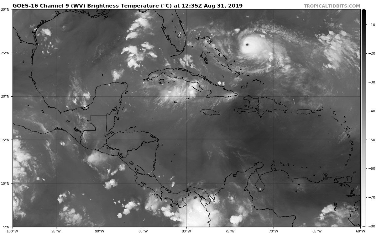
I wonder why a strong Dorian (which would be influenced more my 300MB steering) wouldn’t get pushed more west into South or Central Florida with that ULL over Cuba forcing it west?
I know there are other steering levels in play here but you wonder if that ULL may have more influence than models think right now?
I know there are other steering levels in play here but you wonder if that ULL may have more influence than models think right now?
6 likes
Re: ATL: DORIAN - Hurricane - Discussion
gatorcane wrote:I wonder why a strong Dorian wouldn’t get pushed more west into South or Central Florida with that ULL over Cuba forcing it west?
I know there are other steering levels in play here but you wonder if that ULL may have more influence than models think right now?
https://i.postimg.cc/kXQ7pYZy/goes16-wv-mid-watl-201908311235.jpg
Especially if the models underestimated the strength of the ULL.
1 likes

Re: ATL: DORIAN - Hurricane - Discussion
gatorcane wrote:On satellite it looks due west along 26N
Last hour is nearly due west as you say, and longer term motion is now probably around 280 or so. It matches closely what the 06z ECM suggested which was a probable hit on the northern Bahamas islands.
I think odds of missing the Bahamas is quite slim at the moment, going to really have to start lifting up WNW in the next few hours.
0 likes
Personal Forecast Disclaimer:
The posts in this forum are NOT official forecast and should not be used as such. They are just the opinion of the poster and may or may not be backed by sound meteorological data. They are NOT endorsed by any professional institution or storm2k.org. For official information, please refer to the NHC and NWS products
The posts in this forum are NOT official forecast and should not be used as such. They are just the opinion of the poster and may or may not be backed by sound meteorological data. They are NOT endorsed by any professional institution or storm2k.org. For official information, please refer to the NHC and NWS products
-
johngaltfla

- Category 5

- Posts: 2073
- Joined: Sun Jul 10, 2005 9:17 pm
- Location: Sarasota County, FL
- Contact:
Re: ATL: DORIAN - Hurricane - Discussion
gatorcane wrote:I wonder why a strong Dorian (which would be influenced more my 300MB steering) wouldn’t get pushed more west into South or Central Florida with that ULL over Cuba forcing it west?
I know there are other steering levels in play here but you wonder if that ULL may have more influence than models think right now?
https://i.postimg.cc/kXQ7pYZy/goes16-wv-mid-watl-201908311235.jpg
I think we are still 24 hours away from any definitive forecast beyond Tuesday. So I'm still doing my preps just in case Dorian decides it wants to top the 1926 storm.
1 likes
-
jlauderdal
- S2K Supporter
- Posts: 7240
- Joined: Wed May 19, 2004 5:46 am
- Location: NE Fort Lauderdale
- Contact:
Re: ATL: DORIAN - Hurricane - Discussion
a little to south is a huge deal on the trajectory, stay tunedSmurfwicked wrote:Appears to be moving due west to me. Is it accurate to say NHC Forecast track and models looked to show a more WNW component than what has actually been occurring with the movement overnight and early this morning? While it doesn't look like its going to be south of forecast points much it still looks like its going to be south of those points at least in the near term.
Just an observation by an untrained eye of course!
1 likes
-
Ian2401
- Category 1

- Posts: 321
- Joined: Thu Sep 14, 2017 5:55 pm
- Location: Tallahassee, Florida
- Contact:
Re: ATL: DORIAN - Hurricane - Discussion
are we getting upper level reconnaissance today? i know many said the ridge is being under represented
1 likes
B.S. Meteorology from Florida State '24 // Current M.S. Meteorology student at Florida State
Research Interests: Rapid Intensification, TC Climatology, TC Modeling
Consult the NHC for official information
Research Interests: Rapid Intensification, TC Climatology, TC Modeling
Consult the NHC for official information
-
supercane4867
- Category 5
- Posts: 4966
- Joined: Wed Nov 14, 2012 10:43 am


Re: ATL: DORIAN - Hurricane - Discussion
According to recon the latest position is at approximately 25.87N & 73.09W to be exact.
1 likes
-
gatorcane
- S2K Supporter
- Posts: 23708
- Age: 48
- Joined: Sun Mar 13, 2005 3:54 pm
- Location: Boca Raton, FL
Re: ATL: DORIAN - Hurricane - Discussion
KWT wrote:gatorcane wrote:On satellite it looks due west along 26N
Last hour is nearly due west as you say, and longer term motion is now probably around 280 or so. It matches closely what the 06z ECM suggested which was a probable hit on the northern Bahamas islands.
I think odds of missing the Bahamas is quite slim at the moment, going to really have to start lifting up WNW in the next few hours.
The HWRF has it moving WNW so seems that model is already not correct.
2 likes
-
decgirl66

- S2K Supporter
- Posts: 292
- Age: 59
- Joined: Sun Aug 29, 2004 1:23 pm
- Location: Titusville, FL
Re: ATL: DORIAN - Hurricane - Discussion
How far off the coast of Florida would this be with the current forecast? Also, I may have missed it in all these pages, but how wide is Dorian now?
0 likes
Re: ATL: DORIAN - Hurricane - Discussion
I hope this is not right, 141 knots by SMFR was not flagged.
132400 2601N 07303W 6986 02791 9687 +084 +018 125127 131 141 052 00
132430 2600N 07304W 6966 02736 9577 +110 +020 122098 127 144 024 03
132400 2601N 07303W 6986 02791 9687 +084 +018 125127 131 141 052 00
132430 2600N 07304W 6966 02736 9577 +110 +020 122098 127 144 024 03
0 likes
Re: ATL: DORIAN - Hurricane - Discussion
Peak (10s) Flt. Lvl. Wind: 131 kts (150.8 mph)
SFMR Peak (10s) Sfc. Wind: 141 kts (162.3 mph)
SFMR Peak (10s) Sfc. Wind: 141 kts (162.3 mph)
0 likes
Personal Forecast Disclaimer:
The posts in this forum are NOT official forecast and should not be used as such. They are just the opinion of the poster and may or may not be backed by sound meteorological data. They are NOT endorsed by any professional institution or storm2k.org. For official information, please refer to the NHC and NWS products.
The posts in this forum are NOT official forecast and should not be used as such. They are just the opinion of the poster and may or may not be backed by sound meteorological data. They are NOT endorsed by any professional institution or storm2k.org. For official information, please refer to the NHC and NWS products.
Who is online
Users browsing this forum: No registered users and 25 guests