ATL: NESTOR - Post-Tropical - Discussion

Moderator: S2k Moderators

Message
Author
User avatar
NDG
S2K Supporter
S2K Supporter
Posts: 14947
Joined: Sun Jul 09, 2006 10:14 pm
Location: Orlando, FL

Re: ATL: SIXTEEN - Potential Tropical Cyclone

#461 Postby NDG » Fri Oct 18, 2019 1:02 pm

Jr0d wrote:
NDG wrote:Poor guy doesn't know that it is stronger than a tropical depression.

https://twitter.com/bamajohne/status/1185223408558063616


Myself, Aric and many others on this forum would be enjoying that cruise!


Me too, but my would had been having a panic attack by now lol.
5 likes   

TallyTracker
Category 2
Category 2
Posts: 586
Joined: Thu Oct 11, 2018 2:46 pm

Re: ATL: SIXTEEN - Potential Tropical Cyclone

#462 Postby TallyTracker » Fri Oct 18, 2019 1:05 pm

NDG wrote:Hmm, three Carnival cruise ships were caught on the path of the storm, somebody gave them the wrong forecast, lol.

https://i.imgur.com/vRwNfU3.png


I’m surprised they didn’t divert the ships away from that area. There has been at least a moderate chance of a tropical storm in the Central Gulf for days now. Plenty of time to head southeast into calmer waters IMO.
2 likes   
Fran '96, Georges '98, Gordon '00, Gabrielle '01, Charley '04, Frances '04, Jeanne '04, Barry '07, Fay '08, Debby '12, Matthew '16, Emily '17, Irma '17, Michael ‘18, Elsa ‘21, Fred ‘21, Mindy ‘21, Nicole ‘22, Idalia ‘23

CrazyC83
Professional-Met
Professional-Met
Posts: 33398
Joined: Tue Mar 07, 2006 11:57 pm
Location: Deep South, for the first time!

Re: ATL: SIXTEEN - Potential Tropical Cyclone

#463 Postby CrazyC83 » Fri Oct 18, 2019 1:19 pm

NDG wrote:Wow, not the type of wx to be out on the deck of this cruise ship.

    Tides and Currents Weather Stations Pressure Air Temp Water Temp Dewpoint Dewpoint Depression Visibility Wind Speed Wind Dir Waves Ship Positions


    Fantasy
    Operator: Carnival Cruise Lines

    Last reported at 2019-Oct-18 15:00 UTC. Time now 2019-Oct-18 17:14 UTC.
    Position N 24°42' W 088°54'.

    Type: Ship. MMSI: 353486000.

    Wind from 200 at 45 knots

    Barometer 999.6 mb


If that is an accurate pressure reading and wind concurrent with each other, the pressure would likely be around 995 mb.
1 likes   

User avatar
gatorcane
S2K Supporter
S2K Supporter
Posts: 23499
Age: 46
Joined: Sun Mar 13, 2005 3:54 pm
Location: Boca Raton, FL

Re: ATL: NESTOR - Tropical Storm - Discussion

#464 Postby gatorcane » Fri Oct 18, 2019 1:20 pm

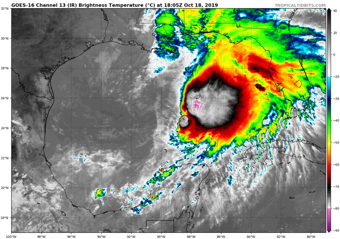
Quite a blob heading for the peninsula:

Image
1 likes   

User avatar
Emmett_Brown
Category 5
Category 5
Posts: 1344
Joined: Wed Aug 24, 2005 9:10 pm
Location: Sarasota FL

Re: ATL: NESTOR - Tropical Storm - Discussion

#465 Postby Emmett_Brown » Fri Oct 18, 2019 1:26 pm

So far, the only wind direction that is absent to make Nestor's circulation complete seems to be N winds. They are probably out there somewhere.
0 likes   

User avatar
wxman57
Moderator-Pro Met
Moderator-Pro Met
Posts: 22506
Age: 66
Joined: Sat Jun 21, 2003 8:06 pm
Location: Houston, TX (southwest)

Re: ATL: NESTOR - Tropical Storm - Discussion

#466 Postby wxman57 » Fri Oct 18, 2019 1:27 pm

26.3N, 89.5W looks right. There isn't any other circulation center. Nothing in the convection to the east. That's where my crosshairs are on the image below. Looks weaker than earlier today. Winds 40-45 kts. With a center so far-removed from the convection (and no convergence into it) it cannot strengthen. It would have to redevelop another center near the center, and I see no sign of that.

Image
3 likes   

SunnyThoughts
Category 5
Category 5
Posts: 2263
Joined: Wed Jul 09, 2003 12:42 pm
Location: Pensacola, Florida

Re: ATL: NESTOR - Tropical Storm - Discussion

#467 Postby SunnyThoughts » Fri Oct 18, 2019 1:29 pm

Do you guys think the NHC will discontinue the warnings/watches West of say...Ft Walton, considering the blob is apparently going to be well East of those areas?
0 likes   

User avatar
wxman57
Moderator-Pro Met
Moderator-Pro Met
Posts: 22506
Age: 66
Joined: Sat Jun 21, 2003 8:06 pm
Location: Houston, TX (southwest)

Re: ATL: NESTOR - Tropical Storm - Discussion

#468 Postby wxman57 » Fri Oct 18, 2019 1:32 pm

SunnyThoughts wrote:Do you guys think the NHC will discontinue the warnings/watches West of say...Ft Walton, considering the blob is apparently going to be well East of those areas?


Those for SE LA can certainly be cancelled.
2 likes   

User avatar
abajan
S2K Supporter
S2K Supporter
Posts: 4175
Joined: Sun Sep 07, 2003 5:10 am
Location: Barbados

Re: ATL: SIXTEEN - Potential Tropical Cyclone

#469 Postby abajan » Fri Oct 18, 2019 1:40 pm

wxman57 wrote:
NDG wrote:Wow, not the type of wx to be out on the deck of this cruise ship.

    Tides and Currents Weather Stations Pressure Air Temp Water Temp Dewpoint Dewpoint Depression Visibility Wind Speed Wind Dir Waves Ship Positions

    Fantasy
    Operator: Carnival Cruise Lines
    Last reported at 2019-Oct-18 15:00 UTC. Time now 2019-Oct-18 17:14 UTC.
    Position N 24°42' W 088°54'.
    Type: Ship. MMSI: 353486000.
    Wind from 200 at 45 knots
    Barometer 999.6 mb


That's the ship on the image below SSE of the center.

http://wxman57.com/images/16e.JPG

They used a pentagram to show its location. How odd.
0 likes   

User avatar
NDG
S2K Supporter
S2K Supporter
Posts: 14947
Joined: Sun Jul 09, 2006 10:14 pm
Location: Orlando, FL

Re: ATL: NESTOR - Tropical Storm - Discussion

#470 Postby NDG » Fri Oct 18, 2019 1:41 pm

wxman57 wrote:26.3N, 89.5W looks right. There isn't any other circulation center. Nothing in the convection to the east. That's where my crosshairs are on the image below. Looks weaker than earlier today. Winds 40-45 kts. With a center so far-removed from the convection (and no convergence into it) it cannot strengthen. It would have to redevelop another center near the center, and I see no sign of that.

http://wxman57.com/images/16f.JPG


The eastern quadrant where the deep convection is has not been sampled yet by the AF, I am sure that's where the 50-50 knot winds still are.
0 likes   

User avatar
Ubuntwo
Category 5
Category 5
Posts: 1089
Age: 30
Joined: Thu Oct 05, 2017 10:41 pm

Re: ATL: NESTOR - Tropical Storm - Discussion

#471 Postby Ubuntwo » Fri Oct 18, 2019 1:43 pm

NDG wrote:
wxman57 wrote:26.3N, 89.5W looks right. There isn't any other circulation center. Nothing in the convection to the east. That's where my crosshairs are on the image below. Looks weaker than earlier today. Winds 40-45 kts. With a center so far-removed from the convection (and no convergence into it) it cannot strengthen. It would have to redevelop another center near the center, and I see no sign of that.

http://wxman57.com/images/16f.JPG


The eastern quadrant where the deep convection is has not been sampled yet by the AF, I am sure that's where the 50-50 knot winds still are.

Most likely, as we've seen before with storms of this structure the highest winds are often contained in squalls far from the center, usually under the deepest convection.
0 likes   
Kendall -> SLO -> PBC

Memorable Storms: Katrina (for its Florida landfall...) Wilma Matthew Irma

User avatar
wxman57
Moderator-Pro Met
Moderator-Pro Met
Posts: 22506
Age: 66
Joined: Sat Jun 21, 2003 8:06 pm
Location: Houston, TX (southwest)

Re: ATL: SIXTEEN - Potential Tropical Cyclone

#472 Postby wxman57 » Fri Oct 18, 2019 1:43 pm

TallyTracker wrote:
NDG wrote:Hmm, three Carnival cruise ships were caught on the path of the storm, somebody gave them the wrong forecast, lol.

https://i.imgur.com/vRwNfU3.png


I’m surprised they didn’t divert the ships away from that area. There has been at least a moderate chance of a tropical storm in the Central Gulf for days now. Plenty of time to head southeast into calmer waters IMO.


Ship captains (have dealt with them for 40 yrs) can be VERY stubborn. This wasn't even a named storm. Ships are on a very tight schedule. Any delays coming to port could cost them quite a lot of money, plus the inconvenience of passengers missing flights home. Bad publicity. Better to go through a little rough weather than to delay arrival by taking a detour.
3 likes   

TallyTracker
Category 2
Category 2
Posts: 586
Joined: Thu Oct 11, 2018 2:46 pm

Re: ATL: NESTOR - Tropical Storm - Discussion

#473 Postby TallyTracker » Fri Oct 18, 2019 1:44 pm

The high tide is 5:39 am at St. Marks tomorrow morning. That’s about the time the strongest south winds will be coming in. I expect to there could be some significant coastal flooding in Wakulla County.
0 likes   
Fran '96, Georges '98, Gordon '00, Gabrielle '01, Charley '04, Frances '04, Jeanne '04, Barry '07, Fay '08, Debby '12, Matthew '16, Emily '17, Irma '17, Michael ‘18, Elsa ‘21, Fred ‘21, Mindy ‘21, Nicole ‘22, Idalia ‘23

CrazyC83
Professional-Met
Professional-Met
Posts: 33398
Joined: Tue Mar 07, 2006 11:57 pm
Location: Deep South, for the first time!

Re: ATL: NESTOR - Tropical Storm - Discussion

#474 Postby CrazyC83 » Fri Oct 18, 2019 1:45 pm

wxman57 wrote:
SunnyThoughts wrote:Do you guys think the NHC will discontinue the warnings/watches West of say...Ft Walton, considering the blob is apparently going to be well East of those areas?


Those for SE LA can certainly be cancelled.


New warnings may need to be added farther east as well.
0 likes   

CrazyC83
Professional-Met
Professional-Met
Posts: 33398
Joined: Tue Mar 07, 2006 11:57 pm
Location: Deep South, for the first time!

Re: ATL: SIXTEEN - Potential Tropical Cyclone

#475 Postby CrazyC83 » Fri Oct 18, 2019 1:47 pm

NDG wrote:Wow, not the type of wx to be out on the deck of this cruise ship.

    Tides and Currents Weather Stations Pressure Air Temp Water Temp Dewpoint Dewpoint Depression Visibility Wind Speed Wind Dir Waves Ship Positions


    Fantasy
    Operator: Carnival Cruise Lines

    Last reported at 2019-Oct-18 15:00 UTC. Time now 2019-Oct-18 17:14 UTC.
    Position N 24°42' W 088°54'.

    Type: Ship. MMSI: 353486000.

    Wind from 200 at 45 knots

    Barometer 999.6 mb


What site did you go to for those obs?
0 likes   

User avatar
NDG
S2K Supporter
S2K Supporter
Posts: 14947
Joined: Sun Jul 09, 2006 10:14 pm
Location: Orlando, FL

Re: ATL: NESTOR - Tropical Storm - Discussion

#476 Postby NDG » Fri Oct 18, 2019 1:50 pm

According to the latest Euro, which shows Nestor becoming a Hurricane for short period of time tonight, the Tampa Bay area will get 50-60 mph wind gusts as the squall line pushes through the area in the morning, but it is usually too aggressive with its wind gusts forecast.
0 likes   

User avatar
wxman57
Moderator-Pro Met
Moderator-Pro Met
Posts: 22506
Age: 66
Joined: Sat Jun 21, 2003 8:06 pm
Location: Houston, TX (southwest)

Re: ATL: NESTOR - Tropical Storm - Discussion

#477 Postby wxman57 » Fri Oct 18, 2019 1:50 pm

I'd estimate that surface winds well east of the weak center are in the 40-45 kt range. Convection has weakened since this morning.
3 likes   

psyclone
S2K Supporter
S2K Supporter
Posts: 4510
Joined: Wed Aug 24, 2005 9:04 pm
Location: palm harbor fl

Re: ATL: NESTOR - Tropical Storm - Discussion

#478 Postby psyclone » Fri Oct 18, 2019 1:53 pm

CrazyC83 wrote:
wxman57 wrote:
SunnyThoughts wrote:Do you guys think the NHC will discontinue the warnings/watches West of say...Ft Walton, considering the blob is apparently going to be well East of those areas?


Those for SE LA can certainly be cancelled.


New warnings may need to be added farther east as well.


I'm certainly expecting Gale-ish/low end ts conditions here along the west coast...whether we get warnings or not. Right now we have a small craft advisory for our marine area...with wind gusts expected to 45 knots and double digit sea heights...lol.
0 likes   

Aric Dunn
Category 5
Category 5
Posts: 21228
Age: 41
Joined: Sun Sep 19, 2004 9:58 pm
Location: Ready for the Chase.
Contact:

Re: ATL: NESTOR - Tropical Storm - Discussion

#479 Postby Aric Dunn » Fri Oct 18, 2019 1:54 pm

maybe maybe.. center is looking better.. exposed.. and sliding east... but looking better... following the convection..
0 likes   
Note: If I make a post that is brief. Please refer back to previous posts for the analysis or reasoning. I do not re-write/qoute what my initial post said each time.
If there is nothing before... then just ask :)

Space & Atmospheric Physicist, Embry-Riddle Aeronautical University,
I believe the sky is falling...

User avatar
wxman57
Moderator-Pro Met
Moderator-Pro Met
Posts: 22506
Age: 66
Joined: Sat Jun 21, 2003 8:06 pm
Location: Houston, TX (southwest)

Re: ATL: NESTOR - Tropical Storm - Discussion

#480 Postby wxman57 » Fri Oct 18, 2019 1:56 pm

26.5N / 89W. No way this has 50kt surface winds.

Image
4 likes   


Return to “2019”

Who is online

Users browsing this forum: No registered users and 4 guests