ATL: DORIAN - Models

Moderator: S2k Moderators

Message
Author
drewschmaltz
S2K Supporter
S2K Supporter
Posts: 350
Joined: Thu Aug 27, 2015 8:19 pm

Re: ATL: DORIAN - Models

#5881 Postby drewschmaltz » Sun Sep 01, 2019 10:51 pm

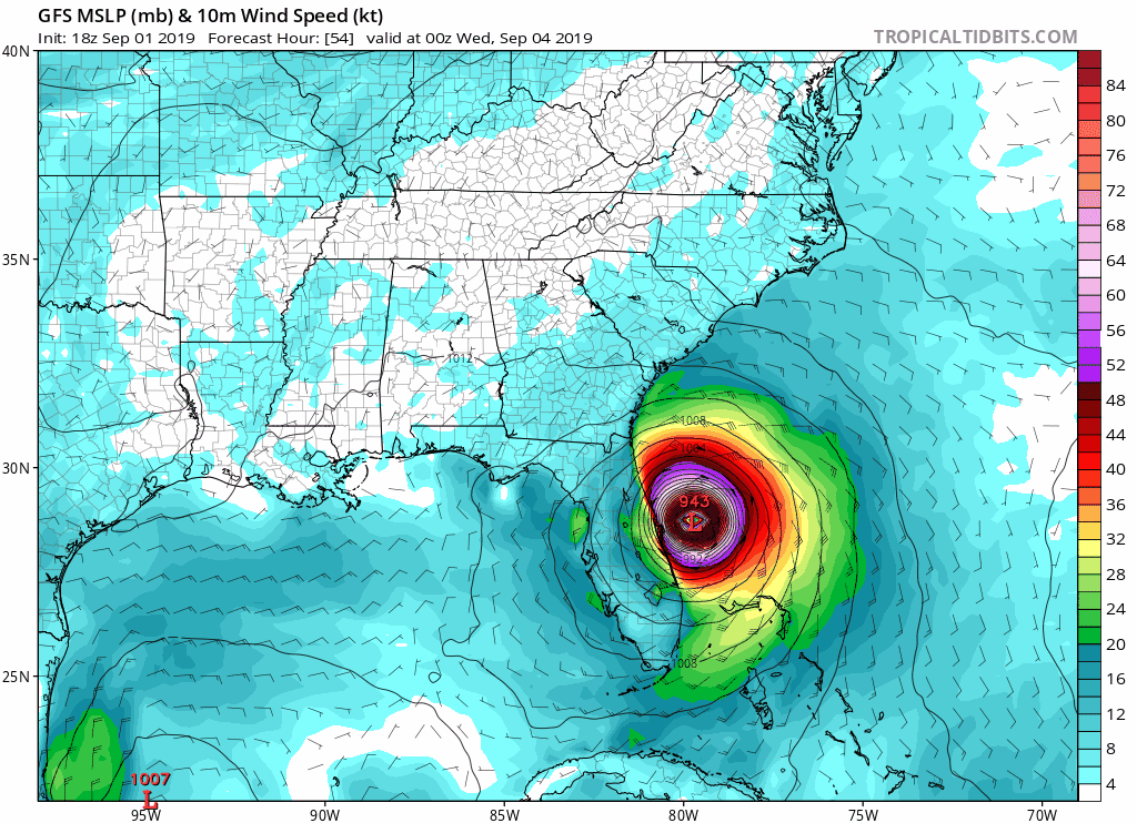
NDG wrote:Can we really trust the GFS when it keeps being right biased on the forecast track in the short term?


Its hard not to wonder the same thing. Well defined cat 5 storm with enormous about of recon data and the initialization is off? It's suppose to tell us what will happen in the future but it can't even accurately tell us what we already know?


I know the models are super complicated and I'm way over simplifying things. But, it's frustrating. Models have been off in the short term for much of Dorian's life. Or am I wrong?
7 likes   
I HAVE ABSOLUTELY NO IDEA WHAT I'M TALKING ABOUT. PLEASE CONSULT SOMEONE WHO DOES. START WITH THE NHC. ALL POSTS ARE FOR ENTERTAINMENT PURPOSES ONLY.

supercane4867
Category 5
Category 5
Posts: 4966
Joined: Wed Nov 14, 2012 10:43 am

Re: ATL: DORIAN - Models

#5882 Postby supercane4867 » Sun Sep 01, 2019 10:52 pm

Raebie wrote:


It looks like you're comparing hour 48 to 54.

Yeah because 18z and 00z is 6 hours apart lol
7 likes   

Raebie
Category 3
Category 3
Posts: 822
Joined: Fri Sep 12, 2003 8:00 pm
Location: Charlotte, NC

Re: ATL: DORIAN - Models

#5883 Postby Raebie » Sun Sep 01, 2019 10:53 pm

supercane4867 wrote:
Raebie wrote:


It looks like you're comparing hour 48 to 54.

Yeah because 18z and 00z is 6 hours apart lol


I need sleep. Carry on. Lol.
7 likes   

Aric Dunn
Category 5
Category 5
Posts: 21238
Age: 42
Joined: Sun Sep 19, 2004 9:58 pm
Location: Ready for the Chase.
Contact:

Re: ATL: DORIAN - Models

#5884 Postby Aric Dunn » Sun Sep 01, 2019 10:56 pm

interesting the GFS is farther west up towards daytona area.... problem is dorian is not moving wnw from 00z.. ...

trash until next run.. maybe by then dorain will be moving wnw without a stall.. next run please..
1 likes   
Note: If I make a post that is brief. Please refer back to previous posts for the analysis or reasoning. I do not re-write/qoute what my initial post said each time.
If there is nothing before... then just ask :)

Space & Atmospheric Physicist, Embry-Riddle Aeronautical University,
I believe the sky is falling...

supercane4867
Category 5
Category 5
Posts: 4966
Joined: Wed Nov 14, 2012 10:43 am

Re: ATL: DORIAN - Models

#5885 Postby supercane4867 » Sun Sep 01, 2019 10:57 pm

Landfall or direct hit near Wilmington NC, could end up worse than Floyd

Image
0 likes   

User avatar
TheDreamTraveler
Category 2
Category 2
Posts: 641
Joined: Sun Aug 22, 2010 3:10 am
Location: PA

Re: ATL: DORIAN - Models

#5886 Postby TheDreamTraveler » Sun Sep 01, 2019 10:57 pm

I wouldn't be surprised if the future runs of the models like the gfs and euro show this thing hugging closer to the coast and even effecting New England and Canada somewhat after North Carolina...just from what I've been seeing from past model runs. It's still a bit early to talk about that but it's starting to become a possibility as well.
3 likes   

User avatar
Hybridstorm_November2001
S2K Supporter
S2K Supporter
Posts: 2811
Joined: Sat Aug 21, 2004 2:50 pm
Location: SW New Brunswick, Canada
Contact:

Re: ATL: DORIAN - Models

#5887 Postby Hybridstorm_November2001 » Sun Sep 01, 2019 11:03 pm

TheDreamTraveler wrote:I wouldn't be surprised if the future runs of the models like the gfs and euro show this thing hugging closer to the coast and even effecting New England and Canada somewhat after North Carolina...just from what I've been seeing from past model runs. It's still a bit early to talk about that but it's starting to become a possibility as well.


A model run of the GFS earlier today (12z I think) eventually turned Drian into an early-season blizzard for Labrador after slamming Nova Scotia, New Brunswick (my region although most effects appeared concentrated in the east, not the far west where I am) & Newfoundland Island. :lol:
3 likes   

User avatar
NDG
S2K Supporter
S2K Supporter
Posts: 15446
Joined: Sun Jul 09, 2006 10:14 pm
Location: Orlando, FL

Re: ATL: DORIAN - Models

#5888 Postby NDG » Sun Sep 01, 2019 11:03 pm

Latest 0z GFS looks a lot like this morning's 06z run, bringing hurricane force winds from the immediate Treasure coast north to at least St Augustine.
1 likes   

User avatar
TheDreamTraveler
Category 2
Category 2
Posts: 641
Joined: Sun Aug 22, 2010 3:10 am
Location: PA

Re: ATL: DORIAN - Models

#5889 Postby TheDreamTraveler » Sun Sep 01, 2019 11:04 pm

Awfully close to the mid atlantic and new england...all it would take is a slight shift west for the effects to be felt harder.

Image
0 likes   

Aric Dunn
Category 5
Category 5
Posts: 21238
Age: 42
Joined: Sun Sep 19, 2004 9:58 pm
Location: Ready for the Chase.
Contact:

Re: ATL: DORIAN - Models

#5890 Postby Aric Dunn » Sun Sep 01, 2019 11:05 pm

This is not the right direction for every models except the euro and UKMET... lol.. it is very quickly separating from the next NHC forecast position..

Image
7 likes   
Note: If I make a post that is brief. Please refer back to previous posts for the analysis or reasoning. I do not re-write/qoute what my initial post said each time.
If there is nothing before... then just ask :)

Space & Atmospheric Physicist, Embry-Riddle Aeronautical University,
I believe the sky is falling...

Tailspin

Re: ATL: DORIAN - Models

#5891 Postby Tailspin » Sun Sep 01, 2019 11:05 pm

Was not long ago EC/GFS dissipated this in the eastern caribbean.
7 likes   

MrJames
Tropical Storm
Tropical Storm
Posts: 189
Joined: Fri Sep 10, 2004 11:56 am
Location: Jax, FL

Re: ATL: DORIAN - Models

#5892 Postby MrJames » Sun Sep 01, 2019 11:08 pm

New UKM shifts west to line up with the rest.

Image
0 likes   

User avatar
TheDreamTraveler
Category 2
Category 2
Posts: 641
Joined: Sun Aug 22, 2010 3:10 am
Location: PA

Re: ATL: DORIAN - Models

#5893 Postby TheDreamTraveler » Sun Sep 01, 2019 11:08 pm

lol

A few meteorologists have started talking about this potentially effecting new england so it's definitely believable that this happens. Of course that could depend a lot on how it interacts with Florida and North Carolina.

Image
Last edited by TheDreamTraveler on Sun Sep 01, 2019 11:10 pm, edited 1 time in total.
3 likes   

shah83
Category 1
Category 1
Posts: 302
Joined: Sun Jul 31, 2016 4:55 pm

Re: ATL: DORIAN - Models

#5894 Postby shah83 » Sun Sep 01, 2019 11:09 pm

00z GFZ absolutely slams Nova Scotia with a extratropical hurricane Dorian.
3 likes   

User avatar
Hybridstorm_November2001
S2K Supporter
S2K Supporter
Posts: 2811
Joined: Sat Aug 21, 2004 2:50 pm
Location: SW New Brunswick, Canada
Contact:

Re: ATL: DORIAN - Models

#5895 Postby Hybridstorm_November2001 » Sun Sep 01, 2019 11:10 pm

TheDreamTraveler wrote:lol

https://i.imgur.com/UIDasvM.png


I'm under the orange to red precip in this graphic (I live right along the Maine/New Brunswick border. Good thing it is still so far out. :lol:
Last edited by Hybridstorm_November2001 on Sun Sep 01, 2019 11:11 pm, edited 1 time in total.
0 likes   

User avatar
TheDreamTraveler
Category 2
Category 2
Posts: 641
Joined: Sun Aug 22, 2010 3:10 am
Location: PA

Re: ATL: DORIAN - Models

#5896 Postby TheDreamTraveler » Sun Sep 01, 2019 11:10 pm

shah83 wrote:00z GFZ absolutely slams Nova Scotia with a extratropical hurricane Dorian.


Not just Nova Scotia but it looks like Maine too.
0 likes   

hurricaneCW
Category 5
Category 5
Posts: 1794
Joined: Wed Mar 03, 2010 6:20 am
Location: Toms River, NJ

Re: ATL: DORIAN - Models

#5897 Postby hurricaneCW » Sun Sep 01, 2019 11:11 pm

TheDreamTraveler wrote:Awfully close to the mid atlantic and new england...all it would take is a slight shift west for the effects to be felt harder.

https://i.imgur.com/nM3Sn4d.png


I think the path will be very similar to a winter noreaster and it'll end up near the 40/70 benchmark with heavy rains, gusty winds for the coast. As a NJ resident I'm more excited about the huge swells as it heads out.
0 likes   

sma10
Category 5
Category 5
Posts: 1710
Joined: Tue Aug 02, 2005 1:13 pm

Re: ATL: DORIAN - Models

#5898 Postby sma10 » Sun Sep 01, 2019 11:14 pm

Ok ... so UKmet says Dorian will only reach 78.3 by 8am tomorrow morning. And 78.8 by 8am Tuesday morning.

Dorian better hit the thrust reversers
1 likes   

NFLnut
Category 2
Category 2
Posts: 541
Joined: Sun Aug 29, 2004 7:37 pm

Re: ATL: DORIAN - Models

#5899 Postby NFLnut » Sun Sep 01, 2019 11:14 pm


Granted, 5-10 miles here or there when it's riding the coast can be a lot but to me that doesn't look all that much closer. Just farther north. Just my $0.02.
0 likes   

Ian2401
Category 1
Category 1
Posts: 307
Joined: Thu Sep 14, 2017 5:55 pm
Location: Tallahassee, Florida
Contact:

Re: ATL: DORIAN - Models

#5900 Postby Ian2401 » Sun Sep 01, 2019 11:15 pm

sma10 wrote:Ok ... so UKmet says Dorian will only reach 78.3 by 8am tomorrow morning. And 78.8 by 8am Tuesday morning.

Dorian better hit the thrust reversers

looks like itll hit 78.3 in an hour or two
0 likes   
B.S. Meteorology from Florida State '24 // Current M.S. Meteorology student at Florida State

Research Interests: Rapid Intensification, TC Climatology, TC Modeling

Consult the NHC for official information


Return to “2019”

Who is online

Users browsing this forum: No registered users and 7 guests