[Formed]07E.SEVEN 2019-07-28 13:50:25
EP, 07, 2019072812, , BEST, 0, 110N, 1065W, 25, 1008, TD, 34, NEQ, 0, 0, 0, 0, 1011, 150, 90, 0, 0, E, 0, , 0, 0, SEVEN, S, 0, , 0, 0, 0, 0, genesis-num, 016, TRANSITIONED, epB02019 to ep072019,
EPAC: FLOSSIE - Remnants
Moderator: S2k Moderators
-
Nancy Smar

- Category 5

- Posts: 1081
- Age: 25
- Joined: Wed Aug 16, 2017 10:03 pm
Re: EPAC: INVEST 90E
0 likes
-
1900hurricane

- Category 5
- Posts: 6063
- Age: 34
- Joined: Fri Feb 06, 2015 12:04 pm
- Location: Houston, TX
- Contact:
Re: EPAC: INVEST 90E
It's getting close, but I wouldn't upgrade quite yet. Based on the latest microwave imagery, the circulation still looks too broad and possibly not closed to the east.

EDIT: and of course as I say that, it gets renumbered.
EDIT: and of course as I say that, it gets renumbered.
4 likes
Contract Meteorologist. TAMU & MSST. Fiercely authentic, one of a kind. We are all given free will, so choose a life meant to be lived. We are the Masters of our own Stories.
Opinions expressed are mine alone.
Follow me on Twitter at @1900hurricane : Read blogs at https://1900hurricane.wordpress.com/
Opinions expressed are mine alone.
Follow me on Twitter at @1900hurricane : Read blogs at https://1900hurricane.wordpress.com/
-
1900hurricane
- Category 5
- Posts: 6063
- Age: 34
- Joined: Fri Feb 06, 2015 12:04 pm
- Location: Houston, TX
- Contact:
EPAC: Tropical Depression 07E
I'm much more convinced of a renumber after viewing the visible/shortwave IR loop. It would be nice for me to use all the resources at my disposal before making a call. Guess I might be a little rusty due to lack of activity? : P

2 likes
Contract Meteorologist. TAMU & MSST. Fiercely authentic, one of a kind. We are all given free will, so choose a life meant to be lived. We are the Masters of our own Stories.
Opinions expressed are mine alone.
Follow me on Twitter at @1900hurricane : Read blogs at https://1900hurricane.wordpress.com/
Opinions expressed are mine alone.
Follow me on Twitter at @1900hurricane : Read blogs at https://1900hurricane.wordpress.com/
-
cycloneye

- Admin

- Posts: 149275
- Age: 69
- Joined: Thu Oct 10, 2002 10:54 am
- Location: San Juan, Puerto Rico
Re: EPAC: SEVEN- Tropical Depression
Tropical Depression Seven-E Discussion Number 1
NWS National Hurricane Center Miami FL EP072019
900 AM MDT Sun Jul 28 2019
First-light visible satellite images have revealed that the area of
low pressure located southwest of the coast of Mexico has developed
a well-defined center of circulation. The convective pattern has
also increased in organization, with a pronounced band wrapping from
the west to north of the center. Dvorak intensity estimates are
T2.0/30 kt from SAB and T1.5/25 kt from TAFB, and advisories are
being initiated on a 30-kt tropical depression.
Tropical Depression Seven-E is moving quickly along the southern
periphery of mid-level ridging that is centered along the U.S/Mexico
border, and its initial motion estimate is 285/18 kt. A weakness in
the ridge west of the Baja California peninsula should allow the
cyclone to slow down some after 24 hours, but the trajectory is
expected to be either westward or west-northwestward for the entire
5-day forecast period. There is very little spread among the track
models, and this initial NHC forecast has generally been placed
between the various multi-model consensus models and the HFIP
Corrected Consensus aid (HCCA).
The convective pattern and upper-level cloud motions suggest that
there's a little bit of shear over the system from the
east-northeast, but that shear should abate over the next 24 hours.
The cyclone will also be over deep warm water, with sea surface
temperatures remaining above 27 degrees Celsius for the entire
forecast period. As a result, steady strengthening is anticipated,
and the NHC intensity forecast is slightly above the IVCN intensity
consensus and close to the HCCA guidance for much of the forecast
period. The depression is forecast to become a tropical storm later
today, and it is likely to become a hurricane in 2 to 3 days.
FORECAST POSITIONS AND MAX WINDS
INIT 28/1500Z 11.2N 107.5W 30 KT 35 MPH
12H 29/0000Z 11.8N 110.4W 35 KT 40 MPH
24H 29/1200Z 12.1N 113.8W 40 KT 45 MPH
36H 30/0000Z 12.1N 116.7W 45 KT 50 MPH
48H 30/1200Z 12.0N 119.3W 55 KT 65 MPH
72H 31/1200Z 12.5N 124.5W 70 KT 80 MPH
96H 01/1200Z 13.5N 130.0W 80 KT 90 MPH
120H 02/1200Z 15.0N 135.5W 90 KT 105 MPH
$$
Forecaster Berg
0 likes
Visit the Caribbean-Central America Weather Thread where you can find at first post web cams,radars
and observations from Caribbean basin members Click Here
and observations from Caribbean basin members Click Here
-
Chris_in_Tampa
- Category 5
- Posts: 5101
- Age: 42
- Joined: Thu Jun 21, 2007 11:06 pm
- Location: Tampa, Florida, USA
- Contact:
Re: EPAC: SEVEN-E - Tropical Depression
Storm Specific Imagery:
Eventually: https://www.star.nesdis.noaa.gov/GOES/f ... d=EP072019
http://rammb.cira.colostate.edu/product ... r=EP072019
https://www.ssd.noaa.gov/PS/TROP/floate ... oater.html
http://tropic.ssec.wisc.edu/real-time/s ... 000&loop=0
Until it becomes Flossie: https://www.nrlmry.navy.mil/tc-bin/tc_h ... km&PROD=ir
http://rammb.cira.colostate.edu/product ... r=EP072019
https://www.tropicaltidbits.com/sat/sat ... product=ir
Other imagery:
https://www.star.nesdis.noaa.gov/GOES/s ... sector=tpw
https://www.weathernerds.org/satellite/floaters/
https://weather.cod.edu/satrad/?parms=g ... 24-0-100-1
https://weather.msfc.nasa.gov/GOES/
http://rammb-slider.cira.colostate.edu/?sat=goes-17
https://realearth.ssec.wisc.edu/?produc ... 128&zoom=4
0 likes
-
Yellow Evan

- Professional-Met

- Posts: 16231
- Age: 27
- Joined: Fri Jul 15, 2011 12:48 pm
- Location: Henderson, Nevada/Honolulu, HI
- Contact:
Re: EPAC: SEVEN-E - Tropical Depression
TXPZ26 KNES 281828
TCSENP
A. 07E (NONAME)
B. 28/1800Z
C. 11.7N
D. 107.9W
E. THREE/GOES-W
F. T2.0/2.0/D1.5/24HRS
G. IR/EIR/VIS
H. REMARKS...DT OF 2.0 IS BASED ON SHEAR PATTERN WITH CIRCULARLY
DFINED LL CLOUD LINES NEAR TO A LARGE COLD OVERCAST. MET IS 1.5 AND PT
IS 2.0. FT IS BASED ON DT.
I. ADDL POSITIONS
NIL
...RAMIREZ
0 likes
-
Kingarabian

- S2K Supporter

- Posts: 16348
- Joined: Sat Aug 08, 2009 3:06 am
- Location: Honolulu, Hawaii
Re: EPAC: SEVEN-E - Tropical Depression
12z Euro has a very close brush with Maui and Oahu as a minimal hurricane or strong TS.

0 likes
RIP Kobe Bryant
-
NotSparta

- Professional-Met
- Posts: 1677
- Age: 24
- Joined: Fri Aug 18, 2017 8:24 am
- Location: Naples, FL
- Contact:
Re: EPAC: SEVEN-E - Tropical Depression
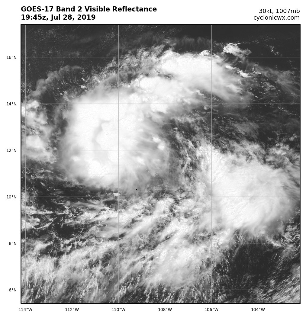
Doing quite well, w/ obvious banding, but some easterly shear here
2 likes
This post was probably an opinion of mine, and in no way is official. Please refer to http://www.hurricanes.gov for official tropical analysis and advisories.
My website, with lots of tropical wx graphics, including satellite and recon: http://cyclonicwx.com
My website, with lots of tropical wx graphics, including satellite and recon: http://cyclonicwx.com
-
cycloneye
- Admin
- Posts: 149275
- Age: 69
- Joined: Thu Oct 10, 2002 10:54 am
- Location: San Juan, Puerto Rico
Re: EPAC: SEVEN-E - Tropical Depression
Tropical Depression Seven-E Discussion Number 2
NWS National Hurricane Center Miami FL EP072019
300 PM MDT Sun Jul 28 2019
The depression has not changed much in organization since the
previous advisory. The system has a broad circulation, with the
low-level center located near the southeastern edge of a long
convective band. Dvorak classifications are now a consensus T2.0
from TAFB and SAB, which supports maintaining an initial intensity
of 30 kt. This is also in good agreement with just-received
ASCAT-C data.
Various objective analyses suggest that the shear over the system is
light, but that doesn't appear to be the case based on high-level
cloud motions seen on visible satellite imagery. Even with the
depression's fast forward speed, the center is chasing the
convection out ahead of it. Given the cyclone's current structure,
only slow strengthening is anticipated during the next 24 hours
while the depression continues to become better organized. Once
an inner core forms, faster strengthening is likely due to low shear
and warm waters, and the cyclone is forecast to become a hurricane
just after 48 hours. In fact, SHIPS Rapid Intensification indices
indicate that there is about a 40 percent chance that the cyclone's
winds will increase by at least 65 kt during the next 3 days.
Therefore, the NHC intensity forecast has been raised from the
previous one, especially after 48 hours, and most closely follows
the HWRF and the European version of the SHIPS model, which lie
above the intensity consensus and near the upper bound of the
guidance envelope.
The initial motion is still fast--285/17 kt--due to the strength of
the mid-level high to the north. Ridging is expected to keep the
cyclone on a westward or west-northwestward heading for the entire
5-day forecast period, with some decrease in forward speed as it
moves south of a weakness in the ridge. The track models are still
tightly clustered, and the NHC track forecast is very close to HCCA
and the other multi-model consensus aids, which also ends up being
very close to the previous official forecast.
FORECAST POSITIONS AND MAX WINDS
INIT 28/2100Z 11.5N 109.1W 30 KT 35 MPH
12H 29/0600Z 11.9N 111.9W 35 KT 40 MPH
24H 29/1800Z 12.1N 115.0W 40 KT 45 MPH
36H 30/0600Z 12.1N 117.9W 50 KT 60 MPH
48H 30/1800Z 12.1N 120.5W 60 KT 70 MPH
72H 31/1800Z 12.8N 125.6W 85 KT 100 MPH
96H 01/1800Z 14.0N 131.0W 90 KT 105 MPH
120H 02/1800Z 15.5N 136.5W 90 KT 105 MPH
$$
Forecaster Berg
0 likes
Visit the Caribbean-Central America Weather Thread where you can find at first post web cams,radars
and observations from Caribbean basin members Click Here
and observations from Caribbean basin members Click Here
-
cycloneye
- Admin
- Posts: 149275
- Age: 69
- Joined: Thu Oct 10, 2002 10:54 am
- Location: San Juan, Puerto Rico
Re: EPAC: SEVEN-E - Tropical Depression
This thing is moving very fast and that may be why it has not consolidated but even with that is looking very good.
0 likes
Visit the Caribbean-Central America Weather Thread where you can find at first post web cams,radars
and observations from Caribbean basin members Click Here
and observations from Caribbean basin members Click Here
-
cycloneye
- Admin
- Posts: 149275
- Age: 69
- Joined: Thu Oct 10, 2002 10:54 am
- Location: San Juan, Puerto Rico
Re: EPAC: SEVEN-E - Tropical Depression
TXPZ26 KNES 290029
TCSENP
A. 07E (NONAME)
B. 29/0000Z
C. 11.9N
D. 110.1W
E. THREE/GOES-W
F. T2.0/2.0/D1.0/24HRS
G. IR/EIR/VIS
H. REMARKS...DT OF 2.0 IS BASED ON CIRCULAR LL CLOUDS VERY NEAR TO A
LARGE COLD OVERCAST. MET IS 1.5 AND PT IS 2.0. FT IS BASED ON PT.
I. ADDL POSITIONS
NIL
...RAMIREZ
TCSENP
A. 07E (NONAME)
B. 29/0000Z
C. 11.9N
D. 110.1W
E. THREE/GOES-W
F. T2.0/2.0/D1.0/24HRS
G. IR/EIR/VIS
H. REMARKS...DT OF 2.0 IS BASED ON CIRCULAR LL CLOUDS VERY NEAR TO A
LARGE COLD OVERCAST. MET IS 1.5 AND PT IS 2.0. FT IS BASED ON PT.
I. ADDL POSITIONS
NIL
...RAMIREZ
0 likes
Visit the Caribbean-Central America Weather Thread where you can find at first post web cams,radars
and observations from Caribbean basin members Click Here
and observations from Caribbean basin members Click Here
-
Yellow Evan
- Professional-Met
- Posts: 16231
- Age: 27
- Joined: Fri Jul 15, 2011 12:48 pm
- Location: Henderson, Nevada/Honolulu, HI
- Contact:
Re: EPAC: SEVEN-E - Tropical Depression
EP, 07, 2019072900, , BEST, 0, 121N, 1101W, 30, 1006, TD, 34, NEQ, 0, 0, 0, 0, 1011, 180, 90, 0, 0, E, 0, , 0, 0, SEVEN, D, 0, , 0, 0, 0, 0, genesis-num, 016,
0 likes
-
Yellow Evan
- Professional-Met
- Posts: 16231
- Age: 27
- Joined: Fri Jul 15, 2011 12:48 pm
- Location: Henderson, Nevada/Honolulu, HI
- Contact:
Re: EPAC: SEVEN-E - Tropical Depression
----- Current Analysis -----
Date : 29 JUL 2019 Time : 020000 UTC
Lat : 11:43:36 N Lon : 110:40:26 W
CI# /Pressure/ Vmax
2.6 /1007.4mb/ 37.0kt
Final T# Adj T# Raw T#
2.2 2.1 2.1
Center Temp : -35.6C Cloud Region Temp : -41.5C
Scene Type : CURVED BAND with 0.38 ARC in LT GRAY
Maximum CURVED BAND with 0.52 ARC in LT GRAY
at Lat: 12:31:12 N Lon: 110:40:11 W
Subtropical Adjustment : OFF
Extratropical Adjustment : OFF
0 likes
-
cycloneye
- Admin
- Posts: 149275
- Age: 69
- Joined: Thu Oct 10, 2002 10:54 am
- Location: San Juan, Puerto Rico
Re: EPAC: SEVEN-E - Tropical Depression
Tropical Depression Seven-E Discussion Number 3
NWS National Hurricane Center Miami FL EP072019
900 PM MDT Sun Jul 28 2019
Conventional and microwave satellite imagery indicates that the
depression has again changed little in organization since the last
advisory. The circulation remains broad, with apparent multiple
vorticity centers rotating around the mean center, and the
convection is in a loosely curved band over the northern semicircle.
Various subjective and objective satellite intensity estimates
are in the 30-35 kt range, and based on the unchanged organization
the initial intensity is held at 30 kt.
The initial motion is 285/18. Deep-layer ridging to the north of
the cyclone should steer it generally westward to west-
northwestward through the forecast period, with some decrease in
the forward speed after 24 h when it moves south of a slight
weakness in the ridge. The track guidance is very tightly clustered
and has changed little from the last advisory. Thus, the new NHC
track forecast track is similar to the previous track and lies near
the various consensus models.
The cyclone is expected to be in a nearly ideal environment for
strengthening for at least the next 3 days, and the intensity
guidance suggests a good chance of rapid intensification once an
inner core becomes established. Given the current structure, it is
expected that it will take 12-24 h for the inner core to form.
Based on this and the guidance, the new NHC intensity forecast calls
for steady strengthening for the first 24 h, followed by a faster
intensification from 24-72 h. The new forecast is again increased
above the previous forecast, and it lies near the upper edge of the
guidance. It should be noted that once rapid intensification
starts, the system could strengthen faster than currently forecast
and reach category 3 or higher intensity. After 72 h, the forecast
track takes the system over slightly cooler water and into an area
of northwesterly shear, and the intensity forecasts calls for slow
weakening during this time.
FORECAST POSITIONS AND MAX WINDS
INIT 29/0300Z 12.2N 111.0W 30 KT 35 MPH
12H 29/1200Z 12.6N 113.7W 35 KT 40 MPH
24H 30/0000Z 12.6N 116.8W 45 KT 50 MPH
36H 30/1200Z 12.6N 119.4W 60 KT 70 MPH
48H 31/0000Z 12.8N 121.9W 75 KT 85 MPH
72H 01/0000Z 13.8N 127.1W 95 KT 110 MPH
96H 02/0000Z 15.0N 132.5W 95 KT 110 MPH
120H 03/0000Z 16.5N 138.5W 90 KT 105 MPH
$$
Forecaster Beven
0 likes
Visit the Caribbean-Central America Weather Thread where you can find at first post web cams,radars
and observations from Caribbean basin members Click Here
and observations from Caribbean basin members Click Here
-
Kingarabian
- S2K Supporter
- Posts: 16348
- Joined: Sat Aug 08, 2009 3:06 am
- Location: Honolulu, Hawaii
Re: EPAC: SEVEN-E - Tropical Depression
We have Flossie:
Tropical Storm FLOSSIE
As of 06:00 UTC Jul 29, 2019:
Location: 12.5°N 112.3°W
Maximum Winds: 35 kt Gusts: nan kt
Minimum Central Pressure: 1005 mb
Environmental Pressure: 1010 mb
Radius of Circulation: 180 NM
Radius of Maximum Wind: 60 NM
Tropical Storm FLOSSIE
As of 06:00 UTC Jul 29, 2019:
Location: 12.5°N 112.3°W
Maximum Winds: 35 kt Gusts: nan kt
Minimum Central Pressure: 1005 mb
Environmental Pressure: 1010 mb
Radius of Circulation: 180 NM
Radius of Maximum Wind: 60 NM
0 likes
RIP Kobe Bryant
-
Kingarabian
- S2K Supporter
- Posts: 16348
- Joined: Sat Aug 08, 2009 3:06 am
- Location: Honolulu, Hawaii
Re: EPAC: SEVEN-E - Tropical Depression
Flossie will likely enter the CPAC as a major hurricane (Cat.4 is very possible) as it will have less shear to deal with in the EPAC compared to Erick. So I think the 00z Euro has the intensity very wrong.

Last edited by Kingarabian on Mon Jul 29, 2019 3:54 am, edited 1 time in total.
0 likes
RIP Kobe Bryant
-
Astromanía
- Category 2

- Posts: 793
- Age: 27
- Joined: Sat Aug 25, 2018 10:34 pm
- Location: Monterrey, N.L, México
Re: EPAC: SEVEN-E - Tropical Depression
Hi Flossie!
My question is, will we see two majors hurricanes at the same time a la Madeline/Lester from 2016? or will Flossie 2019 strenght at a low rate that Erick will reach major status first and then Flossie? Whatever I'm happy that the activity and ACE numbers are going to increase now with a faster rate, but i'm concerned about the treat Flossie can give to Hawaii.
My question is, will we see two majors hurricanes at the same time a la Madeline/Lester from 2016? or will Flossie 2019 strenght at a low rate that Erick will reach major status first and then Flossie? Whatever I'm happy that the activity and ACE numbers are going to increase now with a faster rate, but i'm concerned about the treat Flossie can give to Hawaii.
0 likes
-
Nancy Smar
- Category 5
- Posts: 1081
- Age: 25
- Joined: Wed Aug 16, 2017 10:03 pm
Re: EPAC: SEVEN-E - Tropical Depression
EP, 07, 2019072906, 03, OFCL, 0, 125N, 1123W, 35, 0, TS, 34, NEQ, 70, 0, 0, 60, 0, 0, 0, 45, 0, , 0, ASL, 280, 19, , , 12, NEQ, 75, 0, 0, 0,
EP, 07, 2019072906, 03, OFCL, 3, 125N, 1130W, 35, 1005, TS, 34, NEQ, 70, 0, 0, 60, 0, 0, 0, 45, 0, , 0, ASL, 275, 17, , , 12, NEQ, 75, 0, 0, 60,
EP, 07, 2019072906, 03, OFCL, 12, 127N, 1156W, 45, 0, TS, 34, NEQ, 70, 0, 0, 60, 0, 0, 0, 55, 0, , 0, ASL, 275, 17,
EP, 07, 2019072906, 03, OFCL, 24, 126N, 1185W, 55, 0, TS, 34, NEQ, 70, 50, 0, 60, 0, 0, 0, 65, 0, , 0, ASL, 270, 14,
EP, 07, 2019072906, 03, OFCL, 24, 126N, 1185W, 55, 0, TS, 50, NEQ, 20, 0, 0, 20, 0, 0, 0, 65, 0, , 0, ASL, 270, 14,
EP, 07, 2019072906, 03, OFCL, 36, 128N, 1211W, 65, 0, HU, 34, NEQ, 80, 70, 50, 70, 0, 0, 0, 80, 0, , 0, ASL, 275, 13,
EP, 07, 2019072906, 03, OFCL, 36, 128N, 1211W, 65, 0, HU, 50, NEQ, 30, 20, 20, 20, 0, 0, 0, 80, 0, , 0, ASL, 275, 13,
EP, 07, 2019072906, 03, OFCL, 36, 128N, 1211W, 65, 0, HU, 64, NEQ, 15, 0, 0, 0, 0, 0, 0, 80, 0, , 0, ASL, 275, 13,
EP, 07, 2019072906, 03, OFCL, 48, 133N, 1237W, 75, 0, HU, 34, NEQ, 80, 80, 50, 70, 0, 0, 0, 90, 0, , 0, ASL, 280, 13,
EP, 07, 2019072906, 03, OFCL, 48, 133N, 1237W, 75, 0, HU, 50, NEQ, 30, 20, 20, 30, 0, 0, 0, 90, 0, , 0, ASL, 280, 13,
EP, 07, 2019072906, 03, OFCL, 48, 133N, 1237W, 75, 0, HU, 64, NEQ, 15, 0, 0, 0, 0, 0, 0, 90, 0, , 0, ASL, 280, 13,
EP, 07, 2019072906, 03, OFCL, 72, 145N, 1289W, 95, 0, HU, 34, NEQ, 100, 80, 60, 90, 0, 0, 0, 115, 0, , 0, ASL, 285, 13,
EP, 07, 2019072906, 03, OFCL, 72, 145N, 1289W, 95, 0, HU, 50, NEQ, 40, 20, 20, 40, 0, 0, 0, 115, 0, , 0, ASL, 285, 13,
EP, 07, 2019072906, 03, OFCL, 72, 145N, 1289W, 95, 0, HU, 64, NEQ, 15, 0, 0, 0, 0, 0, 0, 115, 0, , 0, ASL, 285, 13,
EP, 07, 2019072906, 03, OFCL, 96, 158N, 1345W, 95, 0, HU, 34, NEQ, 0, 0, 0, 0, 0, 0, 0, 115, 0, , 0, ASL, 285, 14,
EP, 07, 2019072906, 03, OFCL, 120, 175N, 1405W, 90, 0, HU, 34, NEQ, 0, 0, 0, 0, 0, 0, 0, 110, 0, , 0, ASL, 285, 15,
0 likes
-
Kingarabian
- S2K Supporter
- Posts: 16348
- Joined: Sat Aug 08, 2009 3:06 am
- Location: Honolulu, Hawaii
Re: EPAC: FLOSSIE - Tropical Storm
Tropical Storm Flossie Discussion Number 4
NWS National Hurricane Center Miami FL EP072019
1100 PM HST Sun Jul 28 2019
Over the past several hours, deep convection has developed near the
center of circulation with a large curved band composed of
cloud tops as cold as -80 C enveloping the western semicircle of the
cyclone. A recent ASCAT-C scatterometer pass partially captured the
northeastern quadrant of the system and measured winds of 30 kt
over 75 n mi from the center and it is likely that higher winds were
occurring at that time in the unsampled area closer to the center.
In addition, the mean of the subjective Dvorak satellite intensity
estimates have increased to tropical storm force and therefore the
depression has been upgraded to Tropical Storm Flossie with an
initial intensity of 35 kt.
The initial motion is 275/17 kt. Ridging will persist north of the
cyclone throughout the next several days which will continue to
steer it west to west-northwestward with some decrease in
forward speed by later today as the ridge weakens slightly. The
track guidance is in very good agreement and the official NHC
forecast track is similar to the previous forecast which is very
near the center of the consensus aids.
The environment around Flossie is favorable for strengthening over
the next 72 hours or so, and if the current deep convection can
persist near the center today during the diurnal minimum, then the
inner core of the cyclone will likely become well established over
the next 24 hours. This would allow for steady strengthening to
occur, with Flossie becoming a hurricane sometime on Tuesday.
Although not implicitly shown in the forecast, it is possible that
Flossie could undergo rapid intensification during the next 72 hours
which could result in intensities higher than currently forecast at
those time frames. By day 4, the cyclone is forecast to move
over marginal sea surface temperatures and into a drier, more
stable environment while undergoing increasing northwesterly shear.
This should result in a weakening trend beginning around hour 96
of the forecast period. The official NHC intensity forecast was
changed little from the previous forecast, and remains on the
higher end of the intensity guidance.
FORECAST POSITIONS AND MAX WINDS
INIT 29/0900Z 12.5N 113.0W 35 KT 40 MPH
12H 29/1800Z 12.7N 115.6W 45 KT 50 MPH
24H 30/0600Z 12.6N 118.5W 55 KT 65 MPH
36H 30/1800Z 12.8N 121.1W 65 KT 75 MPH
48H 31/0600Z 13.3N 123.7W 75 KT 85 MPH
72H 01/0600Z 14.5N 128.9W 95 KT 110 MPH
96H 02/0600Z 15.8N 134.5W 95 KT 110 MPH
120H 03/0600Z 17.5N 140.5W 90 KT 105 MPH
$$
Forecaster Latto/Pasch
Intensity forecast continues to be conservative.
0 likes
RIP Kobe Bryant
-
Kingarabian
- S2K Supporter
- Posts: 16348
- Joined: Sat Aug 08, 2009 3:06 am
- Location: Honolulu, Hawaii
Re: EPAC: FLOSSIE - Tropical Storm
00z EPS, shows a bunch of members with green and yellows indicating a TC threat that includes wind and water:

0 likes
RIP Kobe Bryant
Who is online
Users browsing this forum: No registered users and 55 guests