ATL: SEBASTIEN - Post-Tropical
Moderator: S2k Moderators
-
EquusStorm
- Category 5

- Posts: 1649
- Age: 35
- Joined: Thu Nov 07, 2013 1:04 pm
- Location: Jasper, AL
- Contact:
Re: ATL: SEBASTIEN - Tropical Storm
And now a couple models suggest it hits category two as it transitions. Definitely an interesting one, already stronger than I thought it would be. Convection continues to look pretty impressive, but before long is going to be messy as the trough interacts with it.
0 likes
Colors of lost purpose on the canvas of irrelevance
Not a meteorologist, in fact more of an idiot than anything. You should probably check with the NHC or a local NWS office for official information.
Not a meteorologist, in fact more of an idiot than anything. You should probably check with the NHC or a local NWS office for official information.
-
HurricaneRyan
- Category 3

- Posts: 846
- Age: 32
- Joined: Sun Dec 05, 2010 3:05 pm
Re: ATL: SEBASTIEN - Tropical Storm
I see Ariel is giving Sebastien that under the sea boost.
3 likes
Kay '22 Hilary '23
-
Sciencerocks
- Category 5
- Posts: 10181
- Age: 40
- Joined: Thu Jul 06, 2017 1:51 am
Re: ATL: SEBASTIEN - Tropical Storm
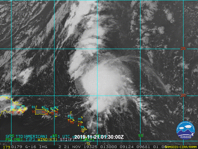
000
WTNT45 KNHC 210831
TCDAT5
Tropical Storm Sebastien Discussion Number 8
NWS National Hurricane Center Miami FL AL202019
500 AM AST Thu Nov 21 2019
Sebastien continues to produce a large area of showers and
thunderstorms over its southeastern quadrant with more disorganized
convection to the north and west of the center. Despite the fair
amount of convection, the cloud pattern lacks banding features and
the center of the storm has been challenging to locate. The
initial intensity is held at 50 kt based on ASCAT data from several
hours ago. This data also indicate that Sebastien's wind field is
quite lopsided, with all of its tropical-storm-force winds confined
to the eastern side of the circulation.
The initial motion of the storm is tough to assess given that there
is more than the usual amount of uncertainty in the current
position, but my best guess is 015/7 kt. A deep-layer trough over
the western Atlantic is approaching Sebastien, and that feature
should cause the storm to accelerate to the northeast during the
next few days. Although the models agree on the overall scenario,
there are major along-track or speed differences among the models,
with the GFS/HWRF/HMON being the fastest solutions and the ECMWF
being the slowest. In fact, at 48 hours, the spread between the GFS
and ECMWF models is more than 700 n mi. The NHC forecast lies
roughly near the middle of the guidance envelope and ends up near
the UKMET model, but this prediction is of low confidence.
Upper-level diffluence, relatively warm SSTs, and a moist
environment should allow for Sebastien to strengthen during the next
24 hours or so. In fact, all of the hurricane regional models show
significant or even rapid intensification during that time period.
Given the asymmetric structure of Sebastien currently, rapid
intensification seems unlikely, and the NHC intensity prediction
lies closer to the lower end of the guidance in the short term.
Beyond 24 hours, Sebastien will be moving into progressively more
hostile conditions of increasing shear, drier air, and cooler
waters. These conditions should end the opportunity for
strengthening and begin the process of extratropical transition.
Sebastien is expected to become fully extratropical in about 48
hours, but this could occur sooner if the GFS is correct or later if
the ECMWF is correct. The extratropical low is forecast to slowly
weaken and dissipate in about 4 days.
FORECAST POSITIONS AND MAX WINDS
INIT 21/0900Z 23.0N 61.2W 50 KT 60 MPH
12H 21/1800Z 24.5N 59.3W 60 KT 70 MPH
24H 22/0600Z 26.6N 56.4W 70 KT 80 MPH
36H 22/1800Z 29.4N 52.0W 70 KT 80 MPH
48H 23/0600Z 32.4N 47.1W 60 KT 70 MPH...POST-TROP/EXTRATROP
72H 24/0600Z 38.6N 34.0W 45 KT 50 MPH...POST-TROP/EXTRATROP
96H 25/0600Z...DISSIPATED
$$
Forecaster Cangialosi
0 likes

Re: ATL: SEBASTIEN - Tropical Storm
Is the upper level diffluence mentioned by the NHC as the reason for intensification coming from the approaching trough?
0 likes
-
Sciencerocks
- Category 5
- Posts: 10181
- Age: 40
- Joined: Thu Jul 06, 2017 1:51 am
-
tolakram
- Admin

- Posts: 20178
- Age: 62
- Joined: Sun Aug 27, 2006 8:23 pm
- Location: Florence, KY (name is Mark)
Re: ATL: SEBASTIEN - Tropical Storm
0 likes
M a r k
- - - - -
Join us in chat: Storm2K Chatroom Invite. Android and IOS apps also available.
The posts in this forum are NOT official forecasts and should not be used as such. Posts are NOT endorsed by any professional institution or STORM2K.org. For official information and forecasts, please refer to NHC and NWS products.
-
wxman57

- Moderator-Pro Met

- Posts: 23172
- Age: 68
- Joined: Sat Jun 21, 2003 8:06 pm
- Location: Houston, TX (southwest)
Re: ATL: SEBASTIEN - Tropical Storm
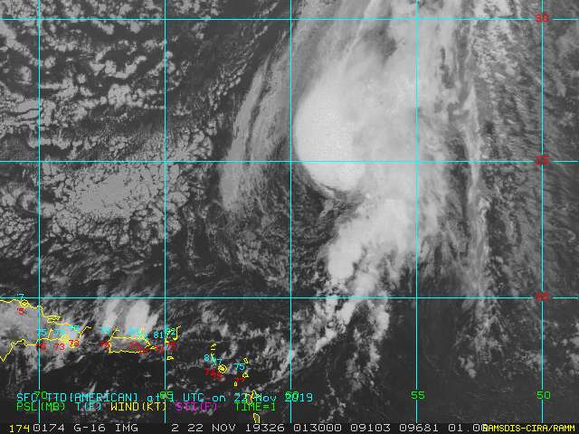
Still looks quite disorganized. The center is well NW of that (weakening) convection. There are only some light to moderate showers near the center. Dry air from behind the front is already flowing into Sebastien's west side. Doesn't look like it is going to become a hurricane.

0 likes
-
tolakram
- Admin
- Posts: 20178
- Age: 62
- Joined: Sun Aug 27, 2006 8:23 pm
- Location: Florence, KY (name is Mark)
Re: ATL: SEBASTIEN - Tropical Storm
Live visible. Maybe a center reformation happened at some point?
https://rammb-slider.cira.colostate.edu/?sat=goes-16&z=3&im=24&ts=1&st=0&et=0&speed=130&motion=loop&map=1&lat=0&opacity%5B0%5D=1&hidden%5B0%5D=0&pause=0&slider=-1&hide_controls=0&mouse_draw=0&follow_feature=0&follow_hide=0&s=rammb-slider&sec=full_disk&p%5B0%5D=band_02&x=13207.3115234375&y=5871.1103515625
https://rammb-slider.cira.colostate.edu/?sat=goes-16&z=3&im=24&ts=1&st=0&et=0&speed=130&motion=loop&map=1&lat=0&opacity%5B0%5D=1&hidden%5B0%5D=0&pause=0&slider=-1&hide_controls=0&mouse_draw=0&follow_feature=0&follow_hide=0&s=rammb-slider&sec=full_disk&p%5B0%5D=band_02&x=13207.3115234375&y=5871.1103515625
0 likes
M a r k
- - - - -
Join us in chat: Storm2K Chatroom Invite. Android and IOS apps also available.
The posts in this forum are NOT official forecasts and should not be used as such. Posts are NOT endorsed by any professional institution or STORM2K.org. For official information and forecasts, please refer to NHC and NWS products.
- - - - -
Join us in chat: Storm2K Chatroom Invite. Android and IOS apps also available.
The posts in this forum are NOT official forecasts and should not be used as such. Posts are NOT endorsed by any professional institution or STORM2K.org. For official information and forecasts, please refer to NHC and NWS products.
-
wxman57
- Moderator-Pro Met
- Posts: 23172
- Age: 68
- Joined: Sat Jun 21, 2003 8:06 pm
- Location: Houston, TX (southwest)
Re: ATL: SEBASTIEN - Tropical Storm
It's already merging with the cold front. No center reformation. Comma-shaped appearance on satellite now.
0 likes
-
CyclonicFury

- Category 5
- Posts: 2032
- Age: 27
- Joined: Sun Jul 02, 2017 12:32 pm
- Location: NC
- Contact:
Re: ATL: SEBASTIEN - Tropical Storm
The ECMWF now seems to show Sebastien remaining a separate entity for several days, but that does not seem likely based on its current satellite appearance.
0 likes
NCSU B.S. in Meteorology Class of 2021. Tropical weather blogger at http://www.cyclonicfury.com. My forecasts and thoughts are NOT official, for official forecasts please consult the National Hurricane Center.
-
tolakram
- Admin
- Posts: 20178
- Age: 62
- Joined: Sun Aug 27, 2006 8:23 pm
- Location: Florence, KY (name is Mark)
Re: ATL: SEBASTIEN - Tropical Storm
It seems to these untrained eyes that the center has jumped in front of the cold front and is showing signs of strengthening. Honestly I can never tell with these borderline systems, but there does seem to be a healthy amount of convection very close to the center.
https://rammb-slider.cira.colostate.edu/?sat=goes-16&z=3&im=12&ts=1&st=0&et=0&speed=130&motion=loop&map=1&lat=0&opacity%5B0%5D=1&hidden%5B0%5D=0&pause=0&slider=-1&hide_controls=0&mouse_draw=0&follow_feature=0&follow_hide=0&s=rammb-slider&sec=full_disk&p%5B0%5D=band_02&x=13961.3896484375&y=5879.2138671875
https://rammb-slider.cira.colostate.edu/?sat=goes-16&z=3&im=12&ts=1&st=0&et=0&speed=130&motion=loop&map=1&lat=0&opacity%5B0%5D=1&hidden%5B0%5D=0&pause=0&slider=-1&hide_controls=0&mouse_draw=0&follow_feature=0&follow_hide=0&s=rammb-slider&sec=full_disk&p%5B0%5D=band_02&x=13961.3896484375&y=5879.2138671875
0 likes
M a r k
- - - - -
Join us in chat: Storm2K Chatroom Invite. Android and IOS apps also available.
The posts in this forum are NOT official forecasts and should not be used as such. Posts are NOT endorsed by any professional institution or STORM2K.org. For official information and forecasts, please refer to NHC and NWS products.
- - - - -
Join us in chat: Storm2K Chatroom Invite. Android and IOS apps also available.
The posts in this forum are NOT official forecasts and should not be used as such. Posts are NOT endorsed by any professional institution or STORM2K.org. For official information and forecasts, please refer to NHC and NWS products.
-
Sciencerocks
- Category 5
- Posts: 10181
- Age: 40
- Joined: Thu Jul 06, 2017 1:51 am

-
Emmett_Brown

- Category 5
- Posts: 1433
- Joined: Wed Aug 24, 2005 9:10 pm
- Location: Sarasota FL
Re: ATL: SEBASTIEN - Tropical Storm
Looks like it is getting much better organized on satellite the last hour or so. Minimal hurricane is still in the cards in my opinion
1 likes
-
Monsoonjr99
- Tropical Storm

- Posts: 210
- Age: 26
- Joined: Fri Sep 21, 2018 11:22 pm
- Location: Inland Empire, SoCal
Re: ATL: SEBASTIEN - Tropical Storm
wxman57 wrote:It's already merging with the cold front. No center reformation. Comma-shaped appearance on satellite now.
Still looks far more tropical than Nestor ever did. Though perhaps the NHC should now classify Sebastien as a subtropical cyclone given its current appearance.
0 likes
The posts in this forum are NOT official forecasts and should not be used as such. They are just the opinion of the poster and may or may not be backed by sound meteorological data. They are NOT endorsed by any professional institution or STORM2K. For official information, please refer to products from the NHC and NWS.
Some Californian who codes things and tracks weather.
Kay '22, Hilary '23
-
EquusStorm
- Category 5
- Posts: 1649
- Age: 35
- Joined: Thu Nov 07, 2013 1:04 pm
- Location: Jasper, AL
- Contact:
Re: ATL: SEBASTIEN - Tropical Storm
Looks more tropical than a lot of storms I've seen classified, as long as the LLC remains distinct from the front long enough to maintain itself... which, the front is catching up pretty fast though. Still not convinced that baroclinic support won't briefly bump it to a hurricane in spite of shear; that's happened with a lot of worse looking November systems
0 likes
Colors of lost purpose on the canvas of irrelevance
Not a meteorologist, in fact more of an idiot than anything. You should probably check with the NHC or a local NWS office for official information.
Not a meteorologist, in fact more of an idiot than anything. You should probably check with the NHC or a local NWS office for official information.

Re: ATL: SEBASTIEN - Tropical Storm
I think the center of circulation is becoming better embedded within the growing mass of convection, but if Sebastien wants to become a hurricane, it needs to do so quickly before it is absorbed by the front.
0 likes
Irene '11 Sandy '12 Hermine '16 5/15/2018 Derecho Fay '20 Isaias '20 Elsa '21 Henri '21 Ida '21
I am only a meteorology enthusiast who knows a decent amount about tropical cyclones. Look to the professional mets, the NHC, or your local weather office for the best information.
I am only a meteorology enthusiast who knows a decent amount about tropical cyclones. Look to the professional mets, the NHC, or your local weather office for the best information.
-
TropicalAnalystwx13

- Category 5
- Posts: 2109
- Age: 28
- Joined: Tue Jul 19, 2011 8:20 pm
- Location: Wilmington, NC
- Contact:
Re: ATL: SEBASTIEN - Tropical Storm
Much improved this afternoon. Should become a hurricane like most expected.

4 likes
-
EquusStorm
- Category 5
- Posts: 1649
- Age: 35
- Joined: Thu Nov 07, 2013 1:04 pm
- Location: Jasper, AL
- Contact:
Re: ATL: SEBASTIEN - Tropical Storm
Yep last two or three hours shows the best improvement of its life cycle, obviously racing against time along the front but should be boosted just enough by that swift upper air divergence to push it over the threshold as it transitions... usually takes that extra transition boost with these mid Atlantic super late season storms. Pretty fascinating though. Fingers crossed it passes the 65kt mark; 7 hurricanes is a little closer to a reasonable ratio for the total storm number.
1 likes
Colors of lost purpose on the canvas of irrelevance
Not a meteorologist, in fact more of an idiot than anything. You should probably check with the NHC or a local NWS office for official information.
Not a meteorologist, in fact more of an idiot than anything. You should probably check with the NHC or a local NWS office for official information.
-
CyclonicFury
- Category 5
- Posts: 2032
- Age: 27
- Joined: Sun Jul 02, 2017 12:32 pm
- Location: NC
- Contact:
Re: ATL: SEBASTIEN - Tropical Storm
No change on the 00z best track.
AL, 20, 2019112200, , BEST, 0, 243N, 586W, 50, 999, TS
0 likes
NCSU B.S. in Meteorology Class of 2021. Tropical weather blogger at http://www.cyclonicfury.com. My forecasts and thoughts are NOT official, for official forecasts please consult the National Hurricane Center.
-
Sciencerocks
- Category 5
- Posts: 10181
- Age: 40
- Joined: Thu Jul 06, 2017 1:51 am
Who is online
Users browsing this forum: No registered users and 131 guests