ATL: KAREN - Models

Moderator: S2k Moderators

Message
Author
User avatar
AtlanticWind
S2K Supporter
S2K Supporter
Posts: 1809
Age: 65
Joined: Sun Aug 08, 2004 9:57 pm
Location: Plantation,Fla

Re: ATL: INVEST 99L - Models

#81 Postby AtlanticWind » Sat Sep 21, 2019 6:49 pm

CrazyC83 wrote:
sma10 wrote:Absolutely in love with the 18z GFS.

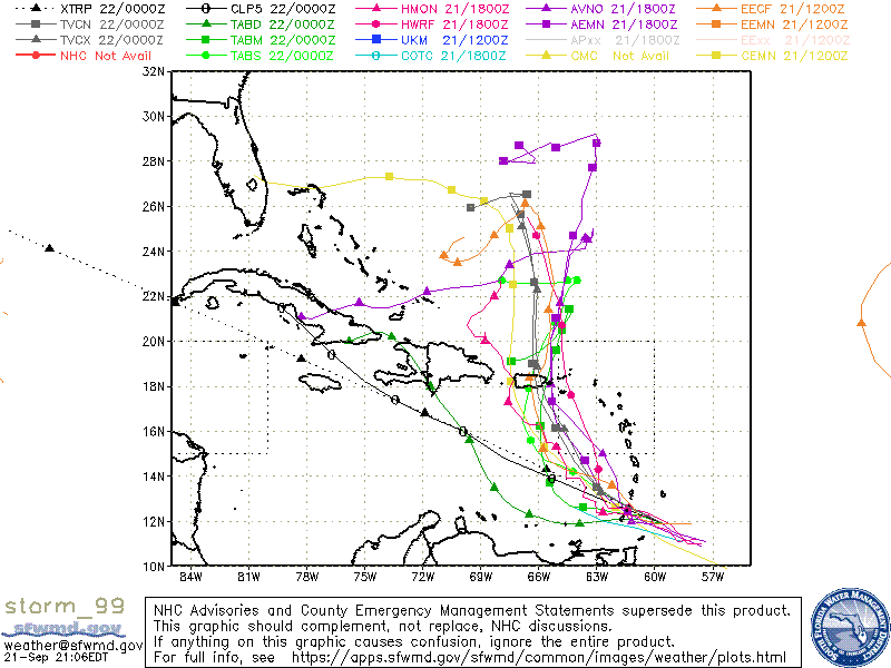
Tropical Genesis in far SE Caribbean, NNW thru Puerto Rico, gets halfway to Bermuda, stops, then heads SW and strikes northern Cuba before heading back into the Caribbean.

Assignment for history buffs: please find an analog to this track :cheesy:


Inez would be the closest parallel. But that was much earlier in the season.

Hurricane Inez 1966 was late Sept into early October
0 likes   

User avatar
gatorcane
S2K Supporter
S2K Supporter
Posts: 23499
Age: 46
Joined: Sun Mar 13, 2005 3:54 pm
Location: Boca Raton, FL

Re: ATL: INVEST 99L - Models

#82 Postby gatorcane » Sat Sep 21, 2019 6:59 pm

18Z HWRF turning to the WNW between 96-108 hours., 969MB
0 likes   

User avatar
gatorcane
S2K Supporter
S2K Supporter
Posts: 23499
Age: 46
Joined: Sun Mar 13, 2005 3:54 pm
Location: Boca Raton, FL

Re: ATL: INVEST 99L - Models

#83 Postby gatorcane » Sat Sep 21, 2019 7:11 pm

950MB heading WNW:

Image
0 likes   

canes92
Tropical Depression
Tropical Depression
Posts: 97
Age: 31
Joined: Tue Mar 06, 2018 1:51 pm

Re: ATL: INVEST 99L - Models

#84 Postby canes92 » Sat Sep 21, 2019 7:16 pm

What does Euro show?
0 likes   

User avatar
Hypercane_Kyle
Category 5
Category 5
Posts: 2902
Joined: Sat Mar 07, 2015 7:58 pm
Location: Cape Canaveral, FL

Re: ATL: INVEST 99L - Models

#85 Postby Hypercane_Kyle » Sat Sep 21, 2019 7:18 pm

canes92 wrote:What does Euro show?


Bends it back WSW just north of the Bahamas (before curving back out again).
0 likes   
My posts are my own personal opinion, defer to the National Hurricane Center (NHC) and other NOAA products for decision making during hurricane season.

aperson
S2K Supporter
S2K Supporter
Posts: 336
Age: 36
Joined: Thu Sep 22, 2005 10:56 pm

Re: ATL: INVEST 99L - Models

#86 Postby aperson » Sat Sep 21, 2019 7:22 pm

canes92 wrote:What does Euro show?


18z euro doesn't run far enough to get to the interesting divergence. 99L is north of PR as a weak system at t=90 at the end of the run.
0 likes   

User avatar
gatorcane
S2K Supporter
S2K Supporter
Posts: 23499
Age: 46
Joined: Sun Mar 13, 2005 3:54 pm
Location: Boca Raton, FL

Re: ATL: INVEST 99L - Models

#87 Postby gatorcane » Sat Sep 21, 2019 7:22 pm

Image
0 likes   

User avatar
chris_fit
Category 5
Category 5
Posts: 3078
Joined: Wed Sep 10, 2003 11:58 pm
Location: Tampa Bay Area, FL
Contact:

Re: ATL: INVEST 99L - Models

#88 Postby chris_fit » Sat Sep 21, 2019 7:37 pm

Image
1 likes   

wx98
Category 5
Category 5
Posts: 1218
Joined: Sat Aug 25, 2018 9:24 pm

Re: ATL: INVEST 99L - Models

#89 Postby wx98 » Sat Sep 21, 2019 7:52 pm


Sort of has the buzzsaw look...
0 likes   

SootyTern
S2K Supporter
S2K Supporter
Posts: 310
Age: 55
Joined: Sun Sep 05, 2004 5:09 pm
Location: NYC (formerly Homestead, FL)

Re: ATL: INVEST 99L - Models

#90 Postby SootyTern » Sat Sep 21, 2019 7:54 pm

I go away from the computer for a few hours and I know there has been a change in some of the models just by the page count :P
6 likes   
Disclaimer:
The posts in this forum are NOT official forecasts and should not be used as such. For official information, please refer to the NHC and NWS products.

Gulf Coast: Opal '95 Georges '98 / So Fla: Katrina '05 Wilma '05 Irma '17

User avatar
AnnularCane
S2K Supporter
S2K Supporter
Posts: 2656
Joined: Thu Jun 08, 2006 9:18 am
Location: Wytheville, VA

Re: ATL: INVEST 99L - Models

#91 Postby AnnularCane » Sat Sep 21, 2019 8:07 pm

wx98 wrote:

Sort of has the buzzsaw look...


Yeah...I forgot this was the models thread for a minute there. :lol:
0 likes   

User avatar
Blown Away
S2K Supporter
S2K Supporter
Posts: 9874
Joined: Wed May 26, 2004 6:17 am

Re: ATL: INVEST 99L - Models

#92 Postby Blown Away » Sat Sep 21, 2019 8:08 pm


TVCN turns WSW near 26N...
0 likes   
Hurricane Eye Experience: David 79, Irene 99, Frances 04, Jeanne 04, Wilma 05... EYE COMING MY WAY IN 2024…
Hurricane Brush Experience: Andrew 92, Erin 95, Floyd 99, Matthew 16, Irma 17, Ian 22, Nicole 22…

User avatar
cycloneye
Admin
Admin
Posts: 139596
Age: 67
Joined: Thu Oct 10, 2002 10:54 am
Location: San Juan, Puerto Rico

Re: ATL: INVEST 99L - Models

#93 Postby cycloneye » Sat Sep 21, 2019 8:10 pm

Look at the bend to the left from majority of models.

Image
1 likes   
Visit the Caribbean-Central America Weather Thread where you can find at first post web cams,radars
and observations from Caribbean basin members Click Here

floridasun78
Category 5
Category 5
Posts: 3755
Joined: Sun May 17, 2009 10:16 pm
Location: miami fl

Re: ATL: INVEST 99L - Models

#94 Postby floridasun78 » Sat Sep 21, 2019 8:19 pm


that new Models run?
0 likes   

User avatar
gatorcane
S2K Supporter
S2K Supporter
Posts: 23499
Age: 46
Joined: Sun Mar 13, 2005 3:54 pm
Location: Boca Raton, FL

Re: ATL: INVEST 99L - Models

#95 Postby gatorcane » Sat Sep 21, 2019 8:22 pm

Blown Away wrote:


TVCN turns WSW near 26N...


Yep:

Image
0 likes   

sma10
Category 5
Category 5
Posts: 1709
Joined: Tue Aug 02, 2005 1:13 pm

Re: ATL: INVEST 99L - Models

#96 Postby sma10 » Sat Sep 21, 2019 8:27 pm

gatorcane wrote:
Blown Away wrote:


TVCN turns WSW near 26N...


Yep:

https://i.postimg.cc/rsKt8vpg/storm-99.gif


There is something very interesting about this map. Notice that CLP5, which is Clipper, basically "climatology" model, ends up at the south central Cuban coast. And so does the GFS! Just slightly different routes ...
0 likes   

User avatar
Blown Away
S2K Supporter
S2K Supporter
Posts: 9874
Joined: Wed May 26, 2004 6:17 am

Re: ATL: INVEST 99L - Models

#97 Postby Blown Away » Sat Sep 21, 2019 8:32 pm

00z Intensity Guidance keeps 99L as weak TS and begins to increase to near Cat 1 after day 4... So the crazy turns do seem to keep intensity down...
0 likes   
Hurricane Eye Experience: David 79, Irene 99, Frances 04, Jeanne 04, Wilma 05... EYE COMING MY WAY IN 2024…
Hurricane Brush Experience: Andrew 92, Erin 95, Floyd 99, Matthew 16, Irma 17, Ian 22, Nicole 22…

User avatar
GeneratorPower
S2K Supporter
S2K Supporter
Posts: 1648
Age: 44
Joined: Sun Dec 18, 2005 11:48 pm
Location: Huntsville, AL

Re: ATL: INVEST 99L - Models

#98 Postby GeneratorPower » Sat Sep 21, 2019 8:35 pm

I’m not sure intensity has such a great impact on track. I think there are obviously situations where it does have a big impact. But most often we see ECMWF and GFS track be very good even when intensity isn’t well represented.
2 likes   

User avatar
AtlanticWind
S2K Supporter
S2K Supporter
Posts: 1809
Age: 65
Joined: Sun Aug 08, 2004 9:57 pm
Location: Plantation,Fla

Re: ATL: INVEST 99L - Models

#99 Postby AtlanticWind » Sat Sep 21, 2019 8:43 pm

Blown Away wrote:00z Intensity Guidance keeps 99L as weak TS and begins to increase to near Cat 1 after day 4... So the crazy turns do seem to keep intensity down...

HWRF has 99L an intense Hurricane in 5 days
SHIPS has it at about hurricane intensity in 5 day
LGEM has it as a strong Tropical Storm in 5 days
EURO has it a mid range Tropical storm but strengthening

Pretty good support for a strong system.
0 likes   

icallstorms
Tropical Wave
Tropical Wave
Posts: 8
Joined: Thu Aug 29, 2019 8:42 pm

Re: ATL: INVEST 99L - Models

#100 Postby icallstorms » Sat Sep 21, 2019 8:53 pm

AtlanticWind wrote:
Blown Away wrote:00z Intensity Guidance keeps 99L as weak TS and begins to increase to near Cat 1 after day 4... So the crazy turns do seem to keep intensity down...

HWRF has 99L an intense Hurricane in 5 days
SHIPS has it at about hurricane intensity in 5 day
LGEM has it as a strong Tropical Storm in 5 days
EURO has it a mid range Tropical storm but strengthening

Pretty good support for a strong system.


And we can’t forget 99L is tied to the Kelvin wave.
1 likes   


Return to “2019”

Who is online

Users browsing this forum: No registered users and 8 guests