ATL: ETA - Post-Tropical - Discussion

Moderator: S2k Moderators

Message
Author
AutoPenalti
Category 5
Category 5
Posts: 3950
Age: 27
Joined: Mon Aug 17, 2015 4:16 pm
Location: Ft. Lauderdale, Florida

Re: ATL: INVEST 96L - Discussion

#101 Postby AutoPenalti » Fri Oct 30, 2020 8:25 am

wxman57 wrote:I'd give it about a 100% chance of being Eta. Most likely, it will move into Nicaragua/Honduras and that will be the end of it. Models indicate a second strong cold front moving across the Gulf Monday, with a giant ridge building over the Gulf by Monday. If it's going to turn NE before CA, then it's going to have to do so pretty soon, which doesn't appear likely.

Someone in the Zeta thread was mentioning the Mitch track of 1998. Mitch went into Central America and eventually emerged back over water near the northeast Yucatan then tracked over south Florida. I'm not saying that will happen in this case, but the models are suggestive of something moving back out over the water a few days past landfall. Most indicate a NE track staying well south of Florida, though.

As for final landfall, I'm putting all my money on Louisiana. ;-)

Well, looks like case closed then. :)
0 likes   
The posts in this forum are NOT official forecasts and should not be used as such. They are just the opinion of the poster and may or may not be backed by sound meteorological data. They are NOT endorsed by any professional institution or STORM2K. For official information, please refer to products from the NHC and NWS.


Model Runs Cheat Sheet:
GFS (5:30 AM/PM, 11:30 AM/PM)
HWRF, GFDL, UKMET, NAVGEM (6:30-8:00 AM/PM, 12:30-2:00 AM/PM)
ECMWF (1:45 AM/PM)

TCVN
is a weighted averaged

User avatar
Iceresistance
Category 5
Category 5
Posts: 8929
Age: 20
Joined: Sat Oct 10, 2020 9:45 am
Location: Tecumseh, OK/Norman, OK

Re: ATL: INVEST 96L - Discussion

#102 Postby Iceresistance » Fri Oct 30, 2020 8:25 am

Found 96L

Image
2 likes   
Bill 2015 & Beta 2020

Winter 2020-2021 :cold:

All observations are in Tecumseh, OK unless otherwise noted.

Winter posts are focused mainly for Oklahoma & Texas.

Take any of my forecasts with a grain of salt, refer to the NWS, SPC, and NHC for official information

Never say Never with weather! Because ANYTHING is possible!

User avatar
Hypercane_Kyle
Category 5
Category 5
Posts: 2900
Joined: Sat Mar 07, 2015 7:58 pm
Location: Cape Canaveral, FL

Re: ATL: INVEST 96L - Discussion

#103 Postby Hypercane_Kyle » Fri Oct 30, 2020 8:33 am

Should become Eta sometime in the next 24-36 hours, tying 2005 for the most active Atlantic hurricane season of all time.
0 likes   
My posts are my own personal opinion, defer to the National Hurricane Center (NHC) and other NOAA products for decision making during hurricane season.

User avatar
gatorcane
S2K Supporter
S2K Supporter
Posts: 23499
Age: 46
Joined: Sun Mar 13, 2005 3:54 pm
Location: Boca Raton, FL

Re: ATL: INVEST 96L - Discussion

#104 Postby gatorcane » Fri Oct 30, 2020 8:37 am

AutoPenalti wrote:
wxman57 wrote:I'd give it about a 100% chance of being Eta. Most likely, it will move into Nicaragua/Honduras and that will be the end of it. Models indicate a second strong cold front moving across the Gulf Monday, with a giant ridge building over the Gulf by Monday. If it's going to turn NE before CA, then it's going to have to do so pretty soon, which doesn't appear likely.

Someone in the Zeta thread was mentioning the Mitch track of 1998. Mitch went into Central America and eventually emerged back over water near the northeast Yucatan then tracked over south Florida. I'm not saying that will happen in this case, but the models are suggestive of something moving back out over the water a few days past landfall. Most indicate a NE track staying well south of Florida, though.

As for final landfall, I'm putting all my money on Louisiana. ;-)

Well, looks like case closed then. :)
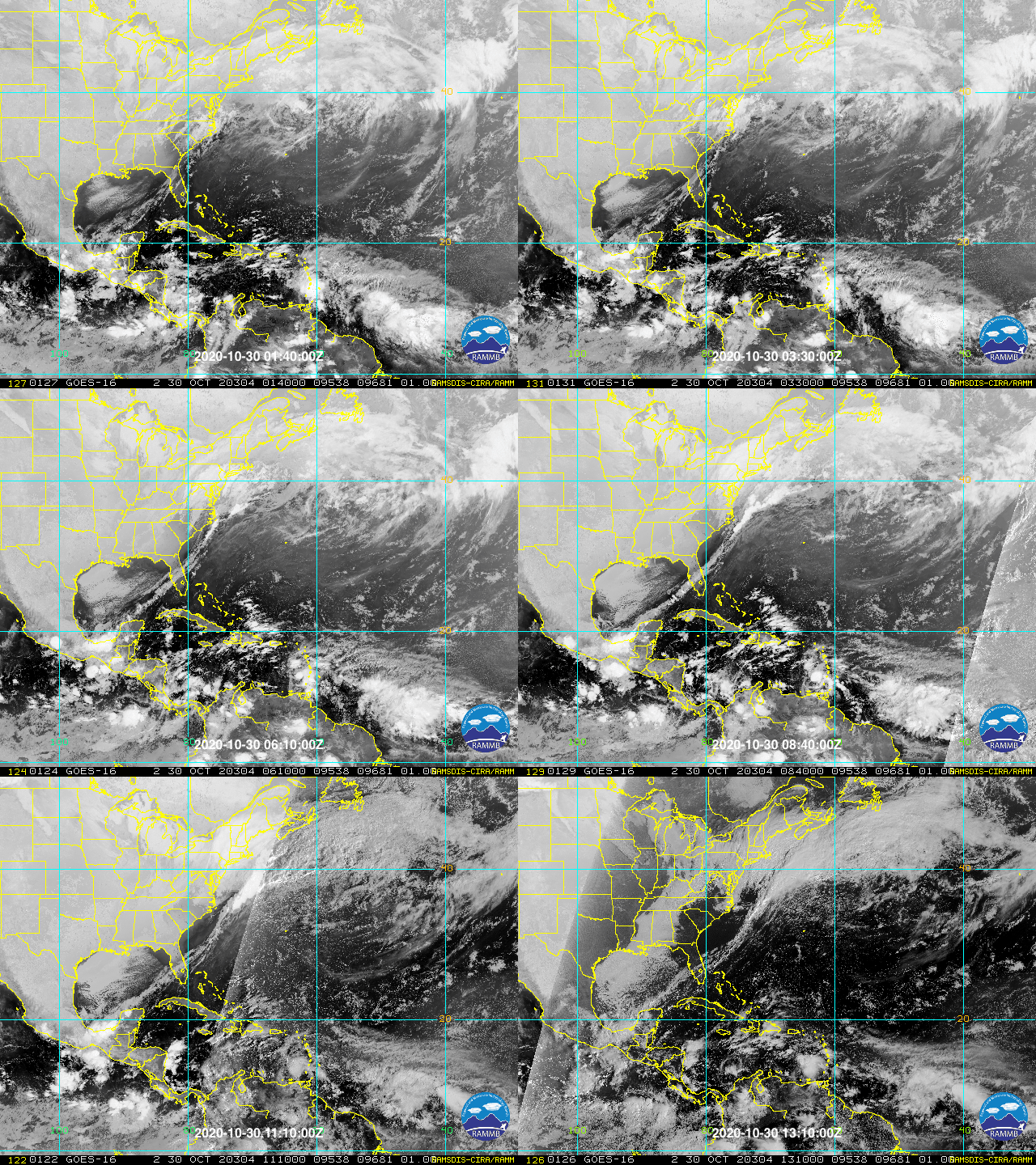

I bolded above my thinking since the beginning on this. Of course there is a chance it loops around maybe going inland into CA and back over the Caribbean. But to get anything significant into the GOM or Florida at this point is very difficult due to building high pressure and the westerlies which may be here to stay now.

One thing I noted this morning is all the low low-level stratocumulus blanketing the Gulf behind the first front. The next front will bring even more in and that is the sign the warmth is being sucked out of the Gulf.

Saved loop:

Image
Last edited by gatorcane on Fri Oct 30, 2020 8:48 am, edited 1 time in total.
1 likes   

tomatkins
Tropical Storm
Tropical Storm
Posts: 220
Joined: Wed Sep 05, 2018 2:11 pm

Re: ATL: INVEST 96L - Discussion

#105 Postby tomatkins » Fri Oct 30, 2020 8:47 am

Hypercane_Kyle wrote:Should become Eta sometime in the next 24-36 hours, tying 2005 for the most active Atlantic hurricane season of all time.

And with almost two months to spare.
1 likes   

User avatar
Iceresistance
Category 5
Category 5
Posts: 8929
Age: 20
Joined: Sat Oct 10, 2020 9:45 am
Location: Tecumseh, OK/Norman, OK

Re: ATL: INVEST 96L - Discussion

#106 Postby Iceresistance » Fri Oct 30, 2020 8:52 am

Can anyone ID a circulation inside 96L? I can't

Image
0 likes   
Bill 2015 & Beta 2020

Winter 2020-2021 :cold:

All observations are in Tecumseh, OK unless otherwise noted.

Winter posts are focused mainly for Oklahoma & Texas.

Take any of my forecasts with a grain of salt, refer to the NWS, SPC, and NHC for official information

Never say Never with weather! Because ANYTHING is possible!

User avatar
Iceresistance
Category 5
Category 5
Posts: 8929
Age: 20
Joined: Sat Oct 10, 2020 9:45 am
Location: Tecumseh, OK/Norman, OK

Re: ATL: INVEST 96L - Discussion

#107 Postby Iceresistance » Fri Oct 30, 2020 8:55 am

The upper level Anticyclone is not far away from 96L

Image
0 likes   
Bill 2015 & Beta 2020

Winter 2020-2021 :cold:

All observations are in Tecumseh, OK unless otherwise noted.

Winter posts are focused mainly for Oklahoma & Texas.

Take any of my forecasts with a grain of salt, refer to the NWS, SPC, and NHC for official information

Never say Never with weather! Because ANYTHING is possible!

al78
Professional-Met
Professional-Met
Posts: 249
Joined: Thu Nov 01, 2018 12:20 pm

Re: ATL: INVEST 96L - Discussion

#108 Postby al78 » Fri Oct 30, 2020 8:59 am

Hypercane_Kyle wrote:Should become Eta sometime in the next 24-36 hours, tying 2005 for the most active Atlantic hurricane season of all time.


In terms of named storms, not in terms of ACE.

Why does the map at the top of the page show TD Twenty-seven, which doesn't exist?
2 likes   

User avatar
wxman57
Moderator-Pro Met
Moderator-Pro Met
Posts: 22493
Age: 66
Joined: Sat Jun 21, 2003 8:06 pm
Location: Houston, TX (southwest)

Re: ATL: INVEST 96L - Discussion

#109 Postby wxman57 » Fri Oct 30, 2020 9:01 am

Had a client email us asking why the Greek alphabet wasn't in "alphabetical order". How does "Eta" come after "Zeta"? :wall:
20 likes   

User avatar
Iceresistance
Category 5
Category 5
Posts: 8929
Age: 20
Joined: Sat Oct 10, 2020 9:45 am
Location: Tecumseh, OK/Norman, OK

Re: ATL: INVEST 96L - Discussion

#110 Postby Iceresistance » Fri Oct 30, 2020 9:01 am

al78 wrote:
Hypercane_Kyle wrote:Should become Eta sometime in the next 24-36 hours, tying 2005 for the most active Atlantic hurricane season of all time.


In terms of named storms, not in terms of ACE.

Why does the map at the top of the page show TD Twenty-seven, which doesn't exist?

Not updated yet because of how busy this season is.
1 likes   
Bill 2015 & Beta 2020

Winter 2020-2021 :cold:

All observations are in Tecumseh, OK unless otherwise noted.

Winter posts are focused mainly for Oklahoma & Texas.

Take any of my forecasts with a grain of salt, refer to the NWS, SPC, and NHC for official information

Never say Never with weather! Because ANYTHING is possible!

User avatar
Iceresistance
Category 5
Category 5
Posts: 8929
Age: 20
Joined: Sat Oct 10, 2020 9:45 am
Location: Tecumseh, OK/Norman, OK

Re: ATL: INVEST 96L - Discussion

#111 Postby Iceresistance » Fri Oct 30, 2020 9:02 am

wxman57 wrote:Had a client email us asking why the Greek alphabet wasn't in "alphabetical order". How does "Eta" come after "Zeta"? :wall:

The Greek Alphabet is different than ours.
0 likes   
Bill 2015 & Beta 2020

Winter 2020-2021 :cold:

All observations are in Tecumseh, OK unless otherwise noted.

Winter posts are focused mainly for Oklahoma & Texas.

Take any of my forecasts with a grain of salt, refer to the NWS, SPC, and NHC for official information

Never say Never with weather! Because ANYTHING is possible!

Nuno
Category 2
Category 2
Posts: 530
Joined: Fri Aug 30, 2019 8:35 am
Location: Coral Gables, FL

Re: ATL: INVEST 96L - Discussion

#112 Postby Nuno » Fri Oct 30, 2020 9:02 am

al78 wrote:
Hypercane_Kyle wrote:Should become Eta sometime in the next 24-36 hours, tying 2005 for the most active Atlantic hurricane season of all time.


In terms of named storms, not in terms of ACE.

Why does the map at the top of the page show TD Twenty-seven, which doesn't exist?


ACE is an arbitrary measurement though, subject to past seasonal averages. We should use this season as a textbook case to not place so much value into ACE when defining a season's effects or activity.
4 likes   
Andrew (1992), Irene (1999), Frances (2004), Katrina (2005), Wilma (2005), Fay (2008), Irma (2017), Eta (2020), Ian (2022)

AutoPenalti
Category 5
Category 5
Posts: 3950
Age: 27
Joined: Mon Aug 17, 2015 4:16 pm
Location: Ft. Lauderdale, Florida

Re: ATL: INVEST 96L - Discussion

#113 Postby AutoPenalti » Fri Oct 30, 2020 9:10 am

wxman57 wrote:Had a client email us asking why the Greek alphabet wasn't in "alphabetical order". How does "Eta" come after "Zeta"? :wall:

I can't believe you have a client that would even ask you that.
1 likes   
The posts in this forum are NOT official forecasts and should not be used as such. They are just the opinion of the poster and may or may not be backed by sound meteorological data. They are NOT endorsed by any professional institution or STORM2K. For official information, please refer to products from the NHC and NWS.


Model Runs Cheat Sheet:
GFS (5:30 AM/PM, 11:30 AM/PM)
HWRF, GFDL, UKMET, NAVGEM (6:30-8:00 AM/PM, 12:30-2:00 AM/PM)
ECMWF (1:45 AM/PM)

TCVN
is a weighted averaged

User avatar
kevin
Category 5
Category 5
Posts: 1779
Age: 25
Joined: Wed Aug 28, 2019 4:35 am

Re: ATL: INVEST 96L - Discussion

#114 Postby kevin » Fri Oct 30, 2020 9:11 am

Yes. Not to restart an OT ACE discussion, but ACE is very biased towards long lived open ocean systems, whose existence or absence doesn't per se determine how active or conductive a season is. But it does mostly determine the ACE, therefore putting seasons like 2020 with a more active Gulf compared to the open ocean at a disadvtange ACE wise. A season with a closed open ocean but hyperactive Gulf can still be hyperactive, but if you'd only use ACE it would be near impossible for such a season to reach hyperactive levels without at least one long lived storm in the Atlantic.
0 likes   

User avatar
aspen
Category 5
Category 5
Posts: 8059
Joined: Sat Oct 12, 2019 7:10 pm
Location: Connecticut, USA

Re: ATL: INVEST 96L - Discussion

#115 Postby aspen » Fri Oct 30, 2020 9:18 am

Nuno wrote:
al78 wrote:
Hypercane_Kyle wrote:Should become Eta sometime in the next 24-36 hours, tying 2005 for the most active Atlantic hurricane season of all time.


In terms of named storms, not in terms of ACE.

Why does the map at the top of the page show TD Twenty-seven, which doesn't exist?


ACE is an arbitrary measurement though, subject to past seasonal averages. We should use this season as a textbook case to not place so much value into ACE when defining a season's effects or activity.

Since Eta seems so determined to become a Caribbean Cruiser despite November being two days away, I have a feeling it’ll end the “2020’s ACE wasn’t hyperactive” talk within the next week.

Quickly developing system + abnormally high SSTs/OHC + track that’ll take it through those warm waters for >4 days + likelihood of low shear and favorable anticyclones + possibility of stalling and turning north = a recipe for a powerful hurricane and at least a decent ACE generator.
4 likes   
Irene '11 Sandy '12 Hermine '16 5/15/2018 Derecho Fay '20 Isaias '20 Elsa '21 Henri '21 Ida '21

I am only a meteorology enthusiast who knows a decent amount about tropical cyclones. Look to the professional mets, the NHC, or your local weather office for the best information.

User avatar
SFLcane
S2K Supporter
S2K Supporter
Posts: 9621
Age: 46
Joined: Sat Jun 05, 2010 1:44 pm
Location: Lake Worth Florida

Re: ATL: INVEST 96L - Discussion

#116 Postby SFLcane » Fri Oct 30, 2020 9:19 am

wxman57 wrote:I'd give it about a 100% chance of being Eta. Most likely, it will move into Nicaragua/Honduras and that will be the end of it. Models indicate a second strong cold front moving across the Gulf Monday, with a giant ridge building over the Gulf by Monday. If it's going to turn NE before CA, then it's going to have to do so pretty soon, which doesn't appear likely.

Someone in the Zeta thread was mentioning the Mitch track of 1998. Mitch went into Central America and eventually emerged back over water near the northeast Yucatan then tracked over south Florida. I'm not saying that will happen in this case, but the models are suggestive of something moving back out over the water a few days past landfall. Most indicate a NE track staying well south of Florida, though.

As for final landfall, I'm putting all my money on Louisiana. ;-)


See you next year! Wish those folks down in the Caribbean near CA good luck some serious flooding heading there Way.
0 likes   

User avatar
Iceresistance
Category 5
Category 5
Posts: 8929
Age: 20
Joined: Sat Oct 10, 2020 9:45 am
Location: Tecumseh, OK/Norman, OK

Re: ATL: INVEST 96L - Discussion

#117 Postby Iceresistance » Fri Oct 30, 2020 9:21 am

96L is a really small system right now.

Image
0 likes   
Bill 2015 & Beta 2020

Winter 2020-2021 :cold:

All observations are in Tecumseh, OK unless otherwise noted.

Winter posts are focused mainly for Oklahoma & Texas.

Take any of my forecasts with a grain of salt, refer to the NWS, SPC, and NHC for official information

Never say Never with weather! Because ANYTHING is possible!

us89
Category 1
Category 1
Posts: 399
Joined: Wed Sep 04, 2019 11:12 pm
Location: Tallahassee, FL

Re: ATL: INVEST 96L - Discussion

#118 Postby us89 » Fri Oct 30, 2020 9:23 am

wxman57 wrote:Had a client email us asking why the Greek alphabet wasn't in "alphabetical order". How does "Eta" come after "Zeta"? :wall:


I hope you gave them a one-line response with a link to the Wikipedia page on the Greek alphabet. :roll:
0 likes   

User avatar
HurricaneEnzo
Category 2
Category 2
Posts: 724
Joined: Wed Mar 14, 2018 12:18 pm
Location: Newport, NC (Hurricane Alley)

Re: ATL: INVEST 96L - Discussion

#119 Postby HurricaneEnzo » Fri Oct 30, 2020 9:26 am

Hypercane_Kyle wrote:Should become Eta sometime in the next 24-36 hours, tying 2005 for the most active Atlantic hurricane season of all time.


Possibly the busiest if they decide to upgrade TD10 in the post season analysis. Either way still plenty of time to break the record for sure.
0 likes   
Bertha 96' - Fran 96' - Bonnie 98' - Dennis 99' - Floyd 99' - Isabel 03' - Alex 04' - Ophelia 05' - Irene 11' - Arthur 14' - Matthew 16' - Florence 18' - Dorian 19' - Isaias 20' (countless other tropical storms and Hurricane swipes)

I am not a Professional Met just an enthusiast. Get your weather forecasts from the Pros!

User avatar
Iceresistance
Category 5
Category 5
Posts: 8929
Age: 20
Joined: Sat Oct 10, 2020 9:45 am
Location: Tecumseh, OK/Norman, OK

Re: ATL: INVEST 96L - Discussion

#120 Postby Iceresistance » Fri Oct 30, 2020 9:27 am

HurricaneEnzo wrote:
Hypercane_Kyle wrote:Should become Eta sometime in the next 24-36 hours, tying 2005 for the most active Atlantic hurricane season of all time.


Possibly the busiest if they decide to upgrade TD10 in the post season analysis. Either way still plenty of time to break the record for sure.

10? We are WAY past that!
0 likes   
Bill 2015 & Beta 2020

Winter 2020-2021 :cold:

All observations are in Tecumseh, OK unless otherwise noted.

Winter posts are focused mainly for Oklahoma & Texas.

Take any of my forecasts with a grain of salt, refer to the NWS, SPC, and NHC for official information

Never say Never with weather! Because ANYTHING is possible!


Return to “2020”

Who is online

Users browsing this forum: No registered users and 5 guests