ATL: ETA - Models

Moderator: S2k Moderators

Message
Author
AutoPenalti
Category 5
Category 5
Posts: 3950
Age: 27
Joined: Mon Aug 17, 2015 4:16 pm
Location: Ft. Lauderdale, Florida

Re: ATL: INVEST 96L - Models

#101 Postby AutoPenalti » Fri Oct 30, 2020 3:25 pm

TheStormExpert wrote:
AutoPenalti wrote:
TheStormExpert wrote:Why not? All the models have this going into CA either in Nicaragua, Honduras, or at the border. Hard to go against that.

Though I will say the 12z Euro has a low emerging north of Honduras in the NW Caribbean in 7-8 days along with the GFS.

You don't account for beta drift right?

Sorry, but what is beta drift?

Within a rapidly intensifying hurricane, circulations associated with the Beta effect are sufficiently large to cause a westward-moving hurricane to drift northwestward.
0 likes   
The posts in this forum are NOT official forecasts and should not be used as such. They are just the opinion of the poster and may or may not be backed by sound meteorological data. They are NOT endorsed by any professional institution or STORM2K. For official information, please refer to products from the NHC and NWS.


Model Runs Cheat Sheet:
GFS (5:30 AM/PM, 11:30 AM/PM)
HWRF, GFDL, UKMET, NAVGEM (6:30-8:00 AM/PM, 12:30-2:00 AM/PM)
ECMWF (1:45 AM/PM)

TCVN
is a weighted averaged

User avatar
TheStormExpert
Category 5
Category 5
Posts: 8487
Age: 30
Joined: Wed Feb 16, 2011 5:38 pm
Location: Palm Beach Gardens, FL

Re: ATL: INVEST 96L - Models

#102 Postby TheStormExpert » Fri Oct 30, 2020 3:26 pm

Spacecoast wrote:
Deshaunrob17 wrote:
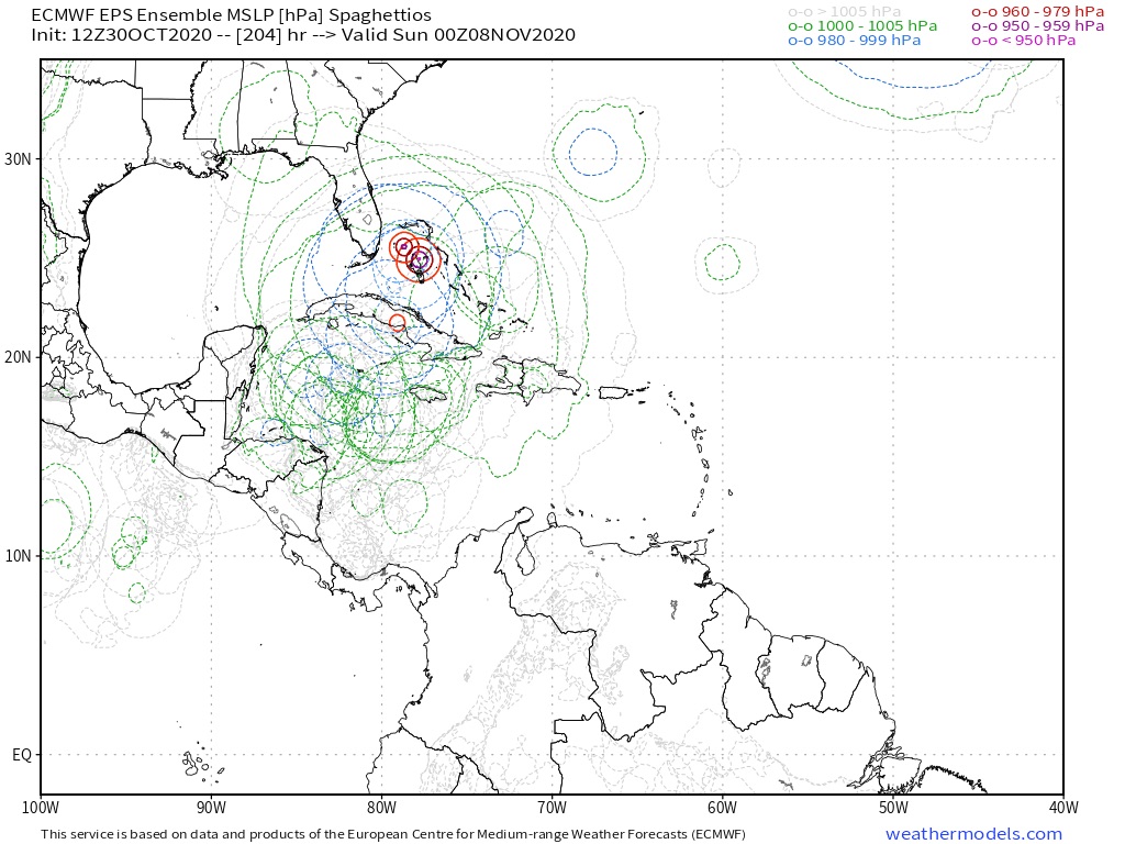
TheStormExpert wrote::uarrow: Looks like quite a handful 12z EPS ensembles bury it into CA before re-emerging in the East Pacific. How’s this compare to 00z EPS?

I could be wrong but I think more members did the CA crossover this morning and yesterday

It looks like slightly less crossovers today
0z EPS:
https://i.ibb.co/RvnQ2DY/Capture10030c.jpg
12z EPS:
https://i.ibb.co/m0gVfxK/Capture10030d.jpg

Still a lot kill it over Central America. If and where it slows down or stalls will be key to survival.
Last edited by TheStormExpert on Fri Oct 30, 2020 4:29 pm, edited 1 time in total.
0 likes   
The following post is NOT an official forecast and should not be used as such. It is just the opinion of the poster and may or may not be backed by sound meteorological data. It is NOT endorsed by storm2k.org.

ClarCari
Category 2
Category 2
Posts: 578
Joined: Thu Aug 13, 2020 11:02 am

Re: ATL: INVEST 96L - Models

#103 Postby ClarCari » Fri Oct 30, 2020 3:28 pm

All of the ensembles that dragged this deep into CA showed a weak system.
All the others that went north were the stronger ones...

Kinda as if a stronger system means a more northerly track hmmmmm.....
0 likes   

cp79
Category 1
Category 1
Posts: 262
Joined: Tue Jul 28, 2020 6:45 pm

Re: ATL: INVEST 96L - Models

#104 Postby cp79 » Fri Oct 30, 2020 3:33 pm

ClarCari wrote:All of the ensembles that dragged this deep into CA showed a weak system.
All the others that went north were the stronger ones...

Kinda as if a stronger system means a more northerly track hmmmmm.....


Not necessarily. A lot of those making it strong are taking it into CA today. The only model now I see actually moving it north is the XTRAP. In other words the north possibilities are plummeting.
0 likes   

ClarCari
Category 2
Category 2
Posts: 578
Joined: Thu Aug 13, 2020 11:02 am

Re: ATL: INVEST 96L - Models

#105 Postby ClarCari » Fri Oct 30, 2020 3:37 pm

cp79 wrote:
ClarCari wrote:All of the ensembles that dragged this deep into CA showed a weak system.
All the others that went north were the stronger ones...

Kinda as if a stronger system means a more northerly track hmmmmm.....


Not necessarily. A lot of those making it strong are taking it into CA today. The only model now I see actually moving it north is the XTRAP. In other words the north possibilities are plummeting.

That does not change the fact at all that all those members keeping it in the CA and EPAC are weak members. The trend for a stronger system is absolutely still there! There is no denying that.
It’s not plummeting.
If anything it’s only strengthening the possibility of a stronger system eventually stalling and getting tugged up.
0 likes   

User avatar
SFLcane
S2K Supporter
S2K Supporter
Posts: 9626
Age: 46
Joined: Sat Jun 05, 2010 1:44 pm
Location: Lake Worth Florida

Re: ATL: INVEST 96L - Models

#106 Postby SFLcane » Fri Oct 30, 2020 3:41 pm

Image
2 likes   

User avatar
Spacecoast
Category 2
Category 2
Posts: 687
Joined: Thu Aug 31, 2017 2:03 pm

Re: ATL: INVEST 96L - Models

#107 Postby Spacecoast » Fri Oct 30, 2020 3:45 pm

ClarCari wrote:
cp79 wrote:
ClarCari wrote:All of the ensembles that dragged this deep into CA showed a weak system.
All the others that went north were the stronger ones...

Kinda as if a stronger system means a more northerly track hmmmmm.....


Not necessarily. A lot of those making it strong are taking it into CA today. The only model now I see actually moving it north is the XTRAP. In other words the north possibilities are plummeting.

That does not change the fact at all that all those members keeping it in the CA and EPAC are weak members. The trend for a stronger system is absolutely still there! There is no denying that.


I could be wrong but,wouldn't those members crossing into CA keep,(or weaken further)? There are mountains in central Nicaragua.
The HWRF / HMON start out very strong,but weakens very quickly after landfall.
Those members that glance,or avoid CA become stronger because they avoided land, not necesarily avoiding land because they are stronger.

Of course, I could be wrong.
0 likes   

ClarCari
Category 2
Category 2
Posts: 578
Joined: Thu Aug 13, 2020 11:02 am

Re: ATL: INVEST 96L - Models

#108 Postby ClarCari » Fri Oct 30, 2020 3:53 pm

Spacecoast wrote:
ClarCari wrote:
cp79 wrote:
Not necessarily. A lot of those making it strong are taking it into CA today. The only model now I see actually moving it north is the XTRAP. In other words the north possibilities are plummeting.

That does not change the fact at all that all those members keeping it in the CA and EPAC are weak members. The trend for a stronger system is absolutely still there! There is no denying that.


I could be wrong but,wouldn't those members crossing into CA keep,(or weaken further)? There are mountains in central Nicaragua.
The HWRF / HMON start out very strong,but weakens very quickly after landfall.
Those members that glance,or avoid CA become stronger because they avoided land, not necesarily avoiding land because they are stronger.

Of course, I could be wrong.

Well in the case of the EPS track ensembles, they display the weak members first in that run that the stronger runs become buried in the chaos lol but allll of the strong members went more north.
I noticed some green members even weakened before “landfall” to blue further suggesting the biggest chance for this to stay south and buried into CA and the EPAC is if it stays pretty weak...which with those deep OHC’s is not very likely to happen.
0 likes   

cp79
Category 1
Category 1
Posts: 262
Joined: Tue Jul 28, 2020 6:45 pm

Re: ATL: INVEST 96L - Models

#109 Postby cp79 » Fri Oct 30, 2020 4:02 pm

ClarCari wrote:
cp79 wrote:
ClarCari wrote:All of the ensembles that dragged this deep into CA showed a weak system.
All the others that went north were the stronger ones...

Kinda as if a stronger system means a more northerly track hmmmmm.....


Not necessarily. A lot of those making it strong are taking it into CA today. The only model now I see actually moving it north is the XTRAP. In other words the north possibilities are plummeting.

That does not change the fact at all that all those members keeping it in the CA and EPAC are weak members. The trend for a stronger system is absolutely still there! There is no denying that.
It’s not plummeting.
If anything it’s only strengthening the possibility of a stronger system eventually stalling and getting tugged up.


Hwrf and Hmon crank it up pretty good and dive it SW into CA. The Para, too.
0 likes   

User avatar
GeneratorPower
S2K Supporter
S2K Supporter
Posts: 1648
Age: 44
Joined: Sun Dec 18, 2005 11:48 pm
Location: Huntsville, AL

Re: ATL: INVEST 96L - Models

#110 Postby GeneratorPower » Fri Oct 30, 2020 4:04 pm

You can talk about models all day but just look at the evolution of the cold front over the continental US for nowcast. The extent to which that front pushes south will give you the answer on Eta.
2 likes   

User avatar
Jr0d
S2K Supporter
S2K Supporter
Posts: 1177
Joined: Tue Aug 27, 2019 10:52 am
Location: Cayo Hueso

Re: ATL: INVEST 96L - Models

#111 Postby Jr0d » Fri Oct 30, 2020 4:15 pm

cp79 wrote:
ClarCari wrote:All of the ensembles that dragged this deep into CA showed a weak system.
All the others that went north were the stronger ones...

Kinda as if a stronger system means a more northerly track hmmmmm.....


Not necessarily. A lot of those making it strong are taking it into CA today. The only model now I see actually moving it north is the XTRAP. In other words the north possibilities are plummeting.


Some ensembles take it NE after brushing CA.

Still I havent seen anything to convinces me it will turn north from the operational models.
0 likes   

User avatar
Nimbus
Category 5
Category 5
Posts: 4933
Joined: Mon Jul 19, 2004 10:54 am

Re: ATL: INVEST 96L - Models

#112 Postby Nimbus » Fri Oct 30, 2020 4:40 pm

TheStormExpert wrote:
Spacecoast wrote:
Deshaunrob17 wrote:I could be wrong but I think more members did the CA crossover this morning and yesterday

It looks like slightly less crossovers today
0z EPS:
https://i.ibb.co/RvnQ2DY/Capture10030c.jpg
12z EPS:
https://i.ibb.co/m0gVfxK/Capture10030d.jpg

Still a lot kill it over Central America. If and where it slows down or stalls will be key to survival.


I think the 18Z runs will be similar to the 12Z but if these models were trending we might get a giant hair ball off Central America. The habitats in those small coastal towns are not robust, however the population density is light till you get down around Puerto Cabezas.
0 likes   

User avatar
Hurricaneman
Category 5
Category 5
Posts: 7284
Age: 43
Joined: Tue Aug 31, 2004 3:24 pm
Location: central florida

Re: ATL: INVEST 96L - Models

#113 Postby Hurricaneman » Fri Oct 30, 2020 5:04 pm

The 18zGFS stalls this 50 miles east of Honduras/Nicaragua
0 likes   

User avatar
SouthFLTropics
Category 5
Category 5
Posts: 4156
Age: 48
Joined: Thu Aug 14, 2003 8:04 am
Location: Port St. Lucie, Florida

Re: ATL: INVEST 96L - Models

#114 Postby SouthFLTropics » Fri Oct 30, 2020 5:04 pm

18z GFS may be coming in with a little different solution. Seems to be slowing down and doing a cyclonic loop offshore of Nicaragua.
0 likes   
Fourth Generation Floridian...With lots of storm knowledge passed down from my elders...

Personal Storm History: David 79, Andrew 92, Erin 95, Floyd 99, Irene 99, Frances 04, Jeanne 04, Wilma 05, Matthew 16, Irma 17

User avatar
SouthFLTropics
Category 5
Category 5
Posts: 4156
Age: 48
Joined: Thu Aug 14, 2003 8:04 am
Location: Port St. Lucie, Florida

Re: ATL: INVEST 96L - Models

#115 Postby SouthFLTropics » Fri Oct 30, 2020 5:15 pm

Uh oh... 150 hours and emerging into the Gulf of Honduras on a NW heading.

EDIT: Looks like it is hung up on the North coast of Honduras. Tons of rainfall for that region. I'm seriously concerned about the loss of life in Central America due to mudslides and flooding.
Last edited by SouthFLTropics on Fri Oct 30, 2020 5:20 pm, edited 2 times in total.
1 likes   
Fourth Generation Floridian...With lots of storm knowledge passed down from my elders...

Personal Storm History: David 79, Andrew 92, Erin 95, Floyd 99, Irene 99, Frances 04, Jeanne 04, Wilma 05, Matthew 16, Irma 17

cp79
Category 1
Category 1
Posts: 262
Joined: Tue Jul 28, 2020 6:45 pm

Re: ATL: INVEST 96L - Models

#116 Postby cp79 » Fri Oct 30, 2020 5:18 pm

SouthFLTropics wrote:18z GFS may be coming in with a little different solution. Seems to be slowing down and doing a cyclonic loop offshore of Nicaragua.


Don’t forget it’s Happy Hour. I never take their 18z models seriously.
0 likes   

User avatar
SouthFLTropics
Category 5
Category 5
Posts: 4156
Age: 48
Joined: Thu Aug 14, 2003 8:04 am
Location: Port St. Lucie, Florida

Re: ATL: INVEST 96L - Models

#117 Postby SouthFLTropics » Fri Oct 30, 2020 5:21 pm

174 hours and it starts moving North. Front coming down through Texas.
0 likes   
Fourth Generation Floridian...With lots of storm knowledge passed down from my elders...

Personal Storm History: David 79, Andrew 92, Erin 95, Floyd 99, Irene 99, Frances 04, Jeanne 04, Wilma 05, Matthew 16, Irma 17

CrazyC83
Professional-Met
Professional-Met
Posts: 33398
Joined: Tue Mar 07, 2006 11:57 pm
Location: Deep South, for the first time!

Re: ATL: INVEST 96L - Models

#118 Postby CrazyC83 » Fri Oct 30, 2020 5:33 pm

I agree that the key is what it does near or over Central America. Inland and dead, near shore and weaken slowly or offshore and stay strong?
2 likes   

User avatar
SouthFLTropics
Category 5
Category 5
Posts: 4156
Age: 48
Joined: Thu Aug 14, 2003 8:04 am
Location: Port St. Lucie, Florida

Re: ATL: INVEST 96L - Models

#119 Postby SouthFLTropics » Fri Oct 30, 2020 5:33 pm

Hmmm...

That is a large circulation in the Florida Straights...

Image
2 likes   
Fourth Generation Floridian...With lots of storm knowledge passed down from my elders...

Personal Storm History: David 79, Andrew 92, Erin 95, Floyd 99, Irene 99, Frances 04, Jeanne 04, Wilma 05, Matthew 16, Irma 17

cp79
Category 1
Category 1
Posts: 262
Joined: Tue Jul 28, 2020 6:45 pm

Re: ATL: INVEST 96L - Models

#120 Postby cp79 » Fri Oct 30, 2020 5:34 pm

SouthFLTropics wrote:Hmmm...

That is a large circulation in the Florida Straights...

https://i.imgur.com/9oB0OIg.gif


Lol happy hour GFS. Not happening. Good laughs, though.
0 likes   


Return to “2020”

Who is online

Users browsing this forum: No registered users and 18 guests