ATL: LAURA - Post-Tropical - Discussion

Moderator: S2k Moderators

Message
Author
Aric Dunn
Category 5
Category 5
Posts: 21238
Age: 42
Joined: Sun Sep 19, 2004 9:58 pm
Location: Ready for the Chase.
Contact:

Re: ATL: THIRTEEN - Tropical Depression - Discussion

#1041 Postby Aric Dunn » Thu Aug 20, 2020 11:59 am

tiger_deF wrote:
AutoPenalti wrote:Aric showing no love for TD 13, at least because I haven’t seen him post within the past couple of hours :lol:


Maybe he's Dunn for the day


I also spend more time in the Discord S2K channels.
2 likes   
Note: If I make a post that is brief. Please refer back to previous posts for the analysis or reasoning. I do not re-write/qoute what my initial post said each time.
If there is nothing before... then just ask :)

Space & Atmospheric Physicist, Embry-Riddle Aeronautical University,
I believe the sky is falling...

User avatar
aspen
Category 5
Category 5
Posts: 8818
Joined: Sat Oct 12, 2019 7:10 pm
Location: Connecticut, USA

Re: ATL: THIRTEEN - Tropical Depression - Discussion

#1042 Postby aspen » Thu Aug 20, 2020 12:04 pm

Only 12 hours of existence and already people are doubting this survives. It wasn’t supposed to have it easy until after passing north of the Lesser Antilles, and it’s behaving like it’s supposed to at this point: struggling as a weak TC. We still have several days to watch this, and it’s likely to encounter much more favorable conditions after 48-72 hours.
14 likes   
Irene '11 Sandy '12 Hermine '16 5/15/2018 Derecho Fay '20 Isaias '20 Elsa '21 Henri '21 Ida '21

I am only a meteorology enthusiast who knows a decent amount about tropical cyclones. Look to the professional mets, the NHC, or your local weather office for the best information.

AxaltaRacing24
Category 5
Category 5
Posts: 1753
Age: 25
Joined: Wed Jul 27, 2016 11:14 am
Location: Jupiter, FL

Re: ATL: THIRTEEN - Tropical Depression - Discussion

#1043 Postby AxaltaRacing24 » Thu Aug 20, 2020 12:08 pm

aspen wrote:Only 12 hours of existence and already people are doubting this survives. It wasn’t supposed to have it easy until after passing north of the Lesser Antilles, and it’s behaving like it’s supposed to at this point: struggling as a weak TC. We still have several days to watch this, and it’s likely to encounter much more favorable conditions after 48-72 hours.

we're just going to have to deal with all the posts doubting this over the next 3 days. it isn't isn't supposed to ramp up until sunday.
4 likes   

User avatar
Hurricaneman
Category 5
Category 5
Posts: 7351
Age: 45
Joined: Tue Aug 31, 2004 3:24 pm
Location: central florida

Re: ATL: THIRTEEN - Tropical Depression - Discussion

#1044 Postby Hurricaneman » Thu Aug 20, 2020 12:09 pm

aspen wrote:Only 12 hours of existence and already people are doubting this survives. It wasn’t supposed to have it easy until after passing north of the Lesser Antilles, and it’s behaving like it’s supposed to at this point: struggling as a weak TC. We still have several days to watch this, and it’s likely to encounter much more favorable conditions after 48-72 hours.

Like said in my forecast the next 24hrs will be rough for 13 but after that all systems go
2 likes   


User avatar
gatorcane
S2K Supporter
S2K Supporter
Posts: 23691
Age: 47
Joined: Sun Mar 13, 2005 3:54 pm
Location: Boca Raton, FL

Re: ATL: THIRTEEN - Tropical Depression - Discussion

#1046 Postby gatorcane » Thu Aug 20, 2020 12:14 pm

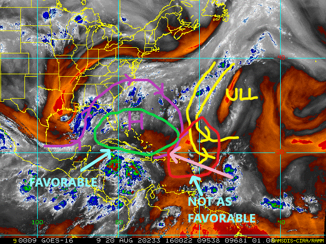
gatorcane wrote:As I have been saying for days, there is alot of dry air (SAL) around not to mention look at the dry air (orange and now even reds showing up so really dry air) ahead WV loop link below. Also some SW shear from the UL to the north will also help inhibit any significant development for the next couple of days. Why NHC is not mentioning these inhibiting factors I am not sure. Conditions will improve as the depression moves north of Hispaniola and into the Bahamas though. I expect a possible increase in organization there but too many inhibiting factors to suggest a major hurricane approaching South Florida still looking at things. A tropical storm or low-end hurricane might be possible, I think the NHC forecast on intensity looks about right for now.

Summary of inhibiting factors:

1) TD moving too quickly
2) Dry air issues from the SAL which will continue as TD moves west into the Bahamas. This becomes particularly problematic if a good core hasn't developed.
3) SW shear from ULL impacting any kind of core developing over the next couple of days.

http://rammb.cira.colostate.edu/ramsdis ... display=24


with WV image markup that I did:

Image
4 likes   

User avatar
Ivanhater
Storm2k Moderator
Storm2k Moderator
Posts: 11162
Age: 38
Joined: Fri Jul 01, 2005 8:25 am
Location: Pensacola

Re: ATL: THIRTEEN - Tropical Depression - Discussion

#1047 Postby Ivanhater » Thu Aug 20, 2020 12:17 pm

We are once again having to delete posts that are getting off topic.

Keep the discussion on topic
4 likes   
Michael


TheStormExpert

Re: ATL: THIRTEEN - Tropical Depression - Discussion

#1049 Postby TheStormExpert » Thu Aug 20, 2020 12:58 pm

Looks like complete crap! Likely no named storm today. It’s more likely that TD #14 becomes Laura and this becomes Marco at the moment.
0 likes   

User avatar
abajan
S2K Supporter
S2K Supporter
Posts: 4234
Joined: Sun Sep 07, 2003 5:10 am
Location: Barbados

Re: ATL: THIRTEEN - Tropical Depression - Discussion

#1050 Postby abajan » Thu Aug 20, 2020 1:03 pm

The intermediate advisory is late.
0 likes   

User avatar
NDG
S2K Supporter
S2K Supporter
Posts: 15446
Joined: Sun Jul 09, 2006 10:14 pm
Location: Orlando, FL

Re: ATL: THIRTEEN - Tropical Depression - Discussion

#1051 Postby NDG » Thu Aug 20, 2020 1:04 pm

I can definitely see an LLC north of the MLC racing to the WNW, convection trying to keep up with it. Don't expect much organization until it reaches the Leeward Islands.
0 likes   

Aric Dunn
Category 5
Category 5
Posts: 21238
Age: 42
Joined: Sun Sep 19, 2004 9:58 pm
Location: Ready for the Chase.
Contact:

Re: ATL: THIRTEEN - Tropical Depression - Discussion

#1052 Postby Aric Dunn » Thu Aug 20, 2020 1:06 pm

NDG wrote:I can definitely see an LLC north of the MLC racing to the WNW, convection trying to keep up with it. Don't expect much organization until it reaches the Leeward Islands.


HWRF has been showing this happening. still interacting with that vorticity SE of barbados. once it rotates north of that feature it should begin to pop convection and slow down some.
Last edited by Aric Dunn on Thu Aug 20, 2020 1:08 pm, edited 1 time in total.
3 likes   
Note: If I make a post that is brief. Please refer back to previous posts for the analysis or reasoning. I do not re-write/qoute what my initial post said each time.
If there is nothing before... then just ask :)

Space & Atmospheric Physicist, Embry-Riddle Aeronautical University,
I believe the sky is falling...

User avatar
Hypercane_Kyle
Category 5
Category 5
Posts: 3353
Joined: Sat Mar 07, 2015 7:58 pm
Location: Cape Canaveral, FL

Re: ATL: THIRTEEN - Tropical Depression - Discussion

#1053 Postby Hypercane_Kyle » Thu Aug 20, 2020 1:07 pm

abajan wrote:The intermediate advisory is late.


It's up for me.

...DEPRESSION CONTINUES WEST-NORTHWESTWARD...


SUMMARY OF 200 PM AST...1800 UTC...INFORMATION
----------------------------------------------
LOCATION...16.0N 52.8W
ABOUT 700 MI...1120 KM E OF THE NORTHERN LEEWARD ISLANDS
MAXIMUM SUSTAINED WINDS...35 MPH...55 KM/H
PRESENT MOVEMENT...WNW OR 290 DEGREES AT 21 MPH...33 KM/H
MINIMUM CENTRAL PRESSURE...1008 MB...29.77 INCHES
2 likes   
My posts are my own personal opinion, defer to the National Hurricane Center (NHC) and other NOAA products for decision making during hurricane season.

psyclone
S2K Supporter
S2K Supporter
Posts: 4763
Joined: Wed Aug 24, 2005 9:04 pm
Location: palm harbor fl

Re: ATL: THIRTEEN - Tropical Depression - Discussion

#1054 Postby psyclone » Thu Aug 20, 2020 1:07 pm

Even if our system degenerates back into an open wave (certainly possible) the fundamental question (at least in my mind) is do we maintain a disturbance that will continue west northwestward briskly that may eventually end up in an area more conducive for development? In my opinion the answer there is more likely than not and that easier bar to jump is probably the more important one. The prospect a rapid, close in development is definitely something to consider. BTW as a side question, have we ever had a depression drop down to a PTC? Perhaps the NHC would just opt to maintain a vigorous disturbance as a TD (if they anticipate redevelopment) in the interest of continuity and not cluster bombing the public with weather geek alphabet soup.
1 likes   

User avatar
SouthFLTropics
Category 5
Category 5
Posts: 4236
Age: 50
Joined: Thu Aug 14, 2003 8:04 am
Location: Port St. Lucie, Florida

Re: ATL: THIRTEEN - Tropical Depression - Discussion

#1055 Postby SouthFLTropics » Thu Aug 20, 2020 1:09 pm

Aric Dunn wrote:
NDG wrote:I can definitely see an LLC north of the MLC racing to the WNW, convection trying to keep up with it. Don't expect much organization until it reaches the Leeward Islands.


HWRF has been showing this happening. still interacting with that vorticity SE of bermuda. once it rotates north of that feature it should begin to pop convection and slow down some.


Look at hi-res visible you can definitely see a vigorous LLC spinning under that sparse convection. It is most likely tilted from the MLC right now and outrunning it at the moment. The fact it has such a vigorous circulation is enough keep me on my toes and not put as much weight into what models may or may not be showing at the moment.
3 likes   
Fourth Generation Florida Native

Personal Storm History: David 79, Andrew 92, Erin 95, Floyd 99, Irene 99, Frances 04, Jeanne 04, Wilma 05, Matthew 16, Irma 17, Ian 22, Nicole 22, Milton 24

User avatar
HurricaneEnzo
Category 2
Category 2
Posts: 739
Joined: Wed Mar 14, 2018 12:18 pm
Location: Newport, NC (Hurricane Alley)

Re: ATL: THIRTEEN - Tropical Depression - Discussion

#1056 Postby HurricaneEnzo » Thu Aug 20, 2020 1:15 pm

I'm not trying to say in anyway these storms will end up the same but we should all remember what happened with Andrew. Struggled for days barely holding onto life then it found some good conditions and the rest is history.

Again, not saying these storms will end up being the same in anyway (it was just easy to see parallels with it struggling and the expected track) but you never know. I'm not writing this off until there is 100% nothing left of it.
3 likes   
Bertha 96' - Fran 96' - Bonnie 98' - Dennis 99' - Floyd 99' - Isabel 03' - Alex 04' - Ophelia 05' - Irene 11' - Arthur 14' - Matthew 16' - Florence 18' - Dorian 19' - Isaias 20' (countless other tropical storms and Hurricane swipes)

I am not a Professional Met just an enthusiast. Get your weather forecasts from the Pros!

hohnywx
Category 2
Category 2
Posts: 508
Age: 34
Joined: Sun Jul 19, 2009 8:34 pm
Location: Hastings-on-Hudson, NY

Re: ATL: THIRTEEN - Tropical Depression - Discussion

#1057 Postby hohnywx » Thu Aug 20, 2020 1:19 pm

HurricaneEnzo wrote:I'm not trying to say in anyway these storms will end up the same but we should all remember what happened with Andrew. Struggled for days barely holding onto life then it found some good conditions and the rest is history.

Again, not saying these storms will end up being the same in anyway but you never know. I'm not writing this off until there is 100% nothing left of it.


Well that's good considering it is forecast to be a hurricane in 4 days.

It seems like some people are expecting this to look like Andrew right now...it's a depression. It was never supposed to rapidly intensify in this area. Trust the NHC.
7 likes   

User avatar
wxman57
Moderator-Pro Met
Moderator-Pro Met
Posts: 22980
Age: 67
Joined: Sat Jun 21, 2003 8:06 pm
Location: Houston, TX (southwest)

Re: ATL: THIRTEEN - Tropical Depression - Discussion

#1058 Postby wxman57 » Thu Aug 20, 2020 1:21 pm

That tiny vortex the NHC identified as a "center" appears to have blown apart.
1 likes   

User avatar
chaser1
S2K Supporter
S2K Supporter
Posts: 5475
Age: 64
Joined: Sat Oct 15, 2005 5:59 pm
Location: Longwood, Fl

Re: ATL: THIRTEEN - Tropical Depression - Discussion

#1059 Postby chaser1 » Thu Aug 20, 2020 1:22 pm


I think this is a great point and have been pondering the same thing. I think much has to do with timing, orientation of the two systems, and whether TD13 will have yet developed an adequate upper level anticyclone itself. TD14 has a larger envelope and is upstream. We could easily see it's outflow disrupt TD13's... however, if the two storms are close in latitude then a broad anticyclone could potentially exist east to west and vent both systems. Near to mid term though, it's reasonable to think a negative impact on 13 will occur.
0 likes   
Andy D

(For official information, please refer to the NHC and NWS products.)

MarioProtVI
Category 4
Category 4
Posts: 935
Age: 24
Joined: Sun Sep 29, 2019 7:33 pm
Location: New Jersey

Re: ATL: THIRTEEN - Tropical Depression - Discussion

#1060 Postby MarioProtVI » Thu Aug 20, 2020 1:24 pm

wxman57 wrote:That tiny vortex the NHC identified as a "center" appears to have blown apart.

I still see a vigorous LLC on satellite. Doesn’t look to have “blown apart”
8 likes   


Return to “2020”

Who is online

Users browsing this forum: No registered users and 4 guests