
ATL: LAURA - Models
Moderator: S2k Moderators


-
supercane4867
- Category 5

- Posts: 4966
- Joined: Wed Nov 14, 2012 10:43 am
Re: ATL: THIRTEEN - Models
06z HWRF is likely the strongest run so far. Probably pushing for a solid CAT5.
0 likes

Re: ATL: THIRTEEN - Models
HMON 06z crashes it into Miami as a major 954 mbar hurricane.

Last edited by kevin on Thu Aug 20, 2020 6:55 am, edited 3 times in total.
2 likes
-
DestinHurricane

- Category 4

- Posts: 935
- Joined: Tue May 01, 2018 8:05 am
- Location: New York, NY
Re: ATL: THIRTEEN - Models
HWRF big shift north. Going to go north of Andros this time. Probably will hit Broward or Palm Beach this run.
0 likes
Michael 2018
-
invest man
- Tropical Storm

- Posts: 209
- Joined: Sun Aug 17, 2008 8:12 pm
Re: ATL: THIRTEEN - Models
SFLcane wrote:06z HWRF clearly clears the islands heading on a westerly course towards potentially FL. Run still not done
Can see a scenario where that western ridge slightly breaks down 24 hrs quicker or models over doing the strength of the ridge, where this could approach SFL south of Miami and take a trip up the eastern 1/3 of the spine before exiting south of Jacksonville. Gfs also shows it slowing to make that curve back NE ward. I think models will soon adjust especially if they begin to depict a high end cat 3 or 4. Not a met, just an observer!
0 likes

-
Shell Mound
- Category 5
- Posts: 2432
- Age: 33
- Joined: Thu Sep 07, 2017 3:39 pm
- Location: St. Petersburg, FL → Scandinavia
Re: ATL: THIRTEEN - Models
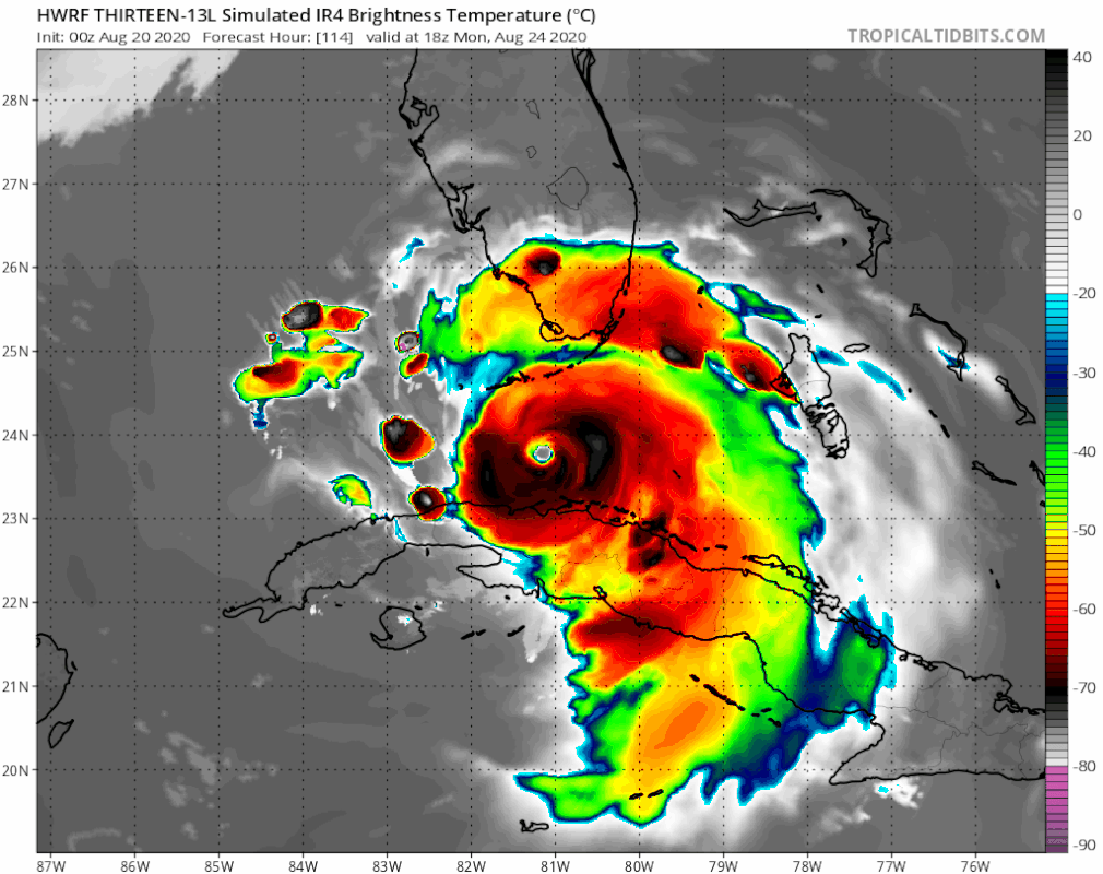
SFLcane wrote:Hwrf gonna end very ugly
Based on the simulated IR presentation, with the convection “weighted” toward the SE quadrant, ridging is likely potent.
The modelled track looks to extend from just N of Grand Turk → N of Mayaguana → over Nassau → Fort Lauderdale area.
0 likes
CVW / MiamiensisWx / Shell Mound
The posts in this forum are NOT official forecasts and should not be used as such. They are just the opinion of the poster and may or may not be backed by sound meteorological data. They are NOT endorsed by any professional institution or STORM2K. For official information, please refer to products from the NHC and NWS.
-
AubreyStorm

- Category 1

- Posts: 337
- Age: 45
- Joined: Fri Jun 16, 2017 6:21 pm
- Location: Texas, USA
Re: ATL: THIRTEEN - Models
caneseddy wrote:HMON landfall over downtown Miami heading WNW

0 likes
The posts are NOT an official forecast. Please REFER to the NHC and NWS for official forecasts and products.
-
AutoPenalti
- Category 5
- Posts: 4091
- Age: 29
- Joined: Mon Aug 17, 2015 4:16 pm
- Location: Ft. Lauderdale, Florida
Re: ATL: THIRTEEN - Models
HWRF may scrape SFL. HR 96 moving NW.
Never mind, it looks to head towards the Space Coast
Never mind, it looks to head towards the Space Coast
Last edited by AutoPenalti on Thu Aug 20, 2020 6:53 am, edited 1 time in total.
0 likes
The posts in this forum are NOT official forecasts and should not be used as such. They are just the opinion of the poster and may or may not be backed by sound meteorological data. They are NOT endorsed by any professional institution or STORM2K. For official information, please refer to products from the NHC and NWS.
Model Runs Cheat Sheet:
GFS (5:30 AM/PM, 11:30 AM/PM)
HWRF, GFDL, UKMET, NAVGEM (6:30-8:00 AM/PM, 12:30-2:00 AM/PM)
ECMWF (1:45 AM/PM)
TCVN is a weighted averaged
Re: ATL: THIRTEEN - Models
HMON, after barreling thought metro SF heads WNW and exits into the Gulf around Tampa Bay
0 likes
-
DestinHurricane
- Category 4
- Posts: 935
- Joined: Tue May 01, 2018 8:05 am
- Location: New York, NY
Re: ATL: THIRTEEN - Models
HWRF recurves. Looks like the magic trapdoor opened. This model is right biased though.
Edit: By recurve I meant miss SFL. Looks like it makes landfall on the treasure coast.
Edit: By recurve I meant miss SFL. Looks like it makes landfall on the treasure coast.
Last edited by DestinHurricane on Thu Aug 20, 2020 6:56 am, edited 2 times in total.
0 likes
Michael 2018
-
WeatherEmperor
- S2K Supporter

- Posts: 4806
- Age: 41
- Joined: Thu Sep 04, 2003 2:54 pm
- Location: South Florida
ATL: THIRTEEN - Models
What am I waking up to?? GFS and HMON into South Florida? Looks like HWRF wants to hit Palm Beach

Sent from my iPhone using Tapatalk
Sent from my iPhone using Tapatalk
0 likes
-
AutoPenalti
- Category 5
- Posts: 4091
- Age: 29
- Joined: Mon Aug 17, 2015 4:16 pm
- Location: Ft. Lauderdale, Florida
Re: ATL: THIRTEEN - Models
I don’t think we should use this for track anyway. The intensity pretty much takes away the fact that conditions will be favorable approaching the Bahamas.
Last edited by AutoPenalti on Thu Aug 20, 2020 6:56 am, edited 1 time in total.
2 likes
The posts in this forum are NOT official forecasts and should not be used as such. They are just the opinion of the poster and may or may not be backed by sound meteorological data. They are NOT endorsed by any professional institution or STORM2K. For official information, please refer to products from the NHC and NWS.
Model Runs Cheat Sheet:
GFS (5:30 AM/PM, 11:30 AM/PM)
HWRF, GFDL, UKMET, NAVGEM (6:30-8:00 AM/PM, 12:30-2:00 AM/PM)
ECMWF (1:45 AM/PM)
TCVN is a weighted averaged
-
Aric Dunn
- Category 5
- Posts: 21238
- Age: 43
- Joined: Sun Sep 19, 2004 9:58 pm
- Location: Ready for the Chase.
- Contact:
Re: ATL: THIRTEEN - Models
6z Euro.. still initiallizing a weak open wave .. looks like are waiting for 12z cycle.
.

.
0 likes
Note: If I make a post that is brief. Please refer back to previous posts for the analysis or reasoning. I do not re-write/qoute what my initial post said each time.
If there is nothing before... then just ask
Space & Atmospheric Physicist, Embry-Riddle Aeronautical University,
I believe the sky is falling...
If there is nothing before... then just ask
Space & Atmospheric Physicist, Embry-Riddle Aeronautical University,
I believe the sky is falling...


-
supercane4867
- Category 5
- Posts: 4966
- Joined: Wed Nov 14, 2012 10:43 am

-
jlauderdal
- S2K Supporter
- Posts: 7240
- Joined: Wed May 19, 2004 5:46 am
- Location: NE Fort Lauderdale
- Contact:
Re: ATL: THIRTEEN - Models
HWRF being the hwrf but it cant be completely discounted based on what we know which is high quality ssts and a low shear environment...best shot for florida and the gulf coast is once again the islands doing there thing, at this point the euro solution if weak will have to be discounted big timesupercane4867 wrote:06z HWRF is likely the strongest run so far. Probably pushing for a solid CAT5.
0 likes
-
DestinHurricane
- Category 4
- Posts: 935
- Joined: Tue May 01, 2018 8:05 am
- Location: New York, NY

Who is online
Users browsing this forum: No registered users and 15 guests