ATL: SALLY - Models
Moderator: S2k Moderators
-
Sean in New Orleans

- Category 5

- Posts: 1794
- Joined: Thu Aug 28, 2003 7:26 pm
- Location: New Orleans, LA 30.0N 90.0W
- Contact:
Re: ATL: NINETEEN - Models
Runs later today should be much closer to verifying. Let’s get the system in the GOM. I’m concerned. I’ve seen this scenario at this location in the GOM at this time of the year many times. It’s rarely good. Lots of influences right now. Watches and warnings will be more accurate by the end of today.
0 likes

Re: ATL: NINETEEN - Models
06z HWRF stronger than the 00z run and becomes a cat 1 hurricane at 48 hours with 76 kt winds (87 mph, 141 kmh).

1 likes
-
Dean4Storms
- S2K Supporter

- Posts: 6358
- Age: 63
- Joined: Sun Aug 31, 2003 1:01 pm
- Location: Miramar Bch. FL
Re: ATL: NINETEEN - Models
06z HMON into P’Cola at 970mb......makes a turn NNE similar to the UKMET 00z run.
0 likes
Re: ATL: NINETEEN - Models
06z HWRF looks like it's gonna make landfall near Biloxi and Pascagoula as a low-end major cat 3 hurricane (101 kts, 116 mph, 187 kmh), only about 10 mph less than Katrina had at its US landfall. This feels like pretty much the worst case scenario, but so far HWRF has been very good with intensity this season and considering we're already within the 80 hour range this is definitely concerning. At least it seems to fall apart quite quickly after landfall.

1 likes

Re: ATL: NINETEEN - Models
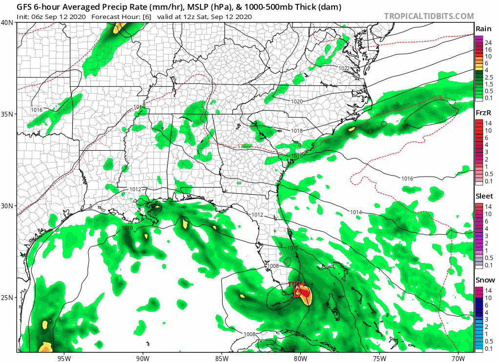
GFS 6Z have it stronger than before, this can blow up.
0 likes
Personal Forecast Disclaimer:
The posts in this forum are NOT official forecast and should not be used as such. They are just the opinion of the poster and may or may not be backed by sound meteorological data. They are NOT endorsed by any professional institution or storm2k.org. For official information, please refer to the NHC and NWS products.
The posts in this forum are NOT official forecast and should not be used as such. They are just the opinion of the poster and may or may not be backed by sound meteorological data. They are NOT endorsed by any professional institution or storm2k.org. For official information, please refer to the NHC and NWS products.
-
LowerAlabamaTider

- Tropical Storm

- Posts: 111
- Age: 66
- Joined: Thu Aug 20, 2020 1:08 pm
Re: ATL: NINETEEN - Models
kevin wrote:06z HWRF looks like it's gonna make landfall near Biloxi and Pascagoula as a low-end major cat 3 hurricane (101 kts, 116 mph, 187 kmh), only about 10 mph less than Katrina had at its US landfall. This feels like pretty much the worst case scenario, but so far HWRF has been very good with intensity this season and considering we're already within the 80 hour range this is definitely concerning. At least it seems to fall apart quite quickly after landfall.
https://i.imgur.com/L4Ged4k.png
This scenario would not be good for us here in SW AL at all either.
1 likes


Re: ATL: NINETEEN - Models
06z Euro doing a good job so far, shows the LLC exiting the FL Peninsula further south than forecasted.
So far on this run is very similar to the earlier 0z run, 20 miles further south.

So far on this run is very similar to the earlier 0z run, 20 miles further south.
0 likes

-
MidnightRain

- Tropical Storm
- Posts: 110
- Joined: Tue Oct 11, 2011 8:26 pm
- Location: NW Florida
Re: ATL: NINETEEN - Models
Getting flashbacks to Laura, models under estimating a building ridge.
1 likes
The posts in this forum are NOT official forecast and should not be used as such. They are just the opinion of the poster and may or may not be backed by sound meteorological data. They are NOT endorsed by any professional institution or storm2k.org. For official information, please refer to the NHC and NWS products.
-
MississippiWx

- S2K Supporter
- Posts: 1720
- Joined: Sat Aug 14, 2010 1:44 pm
- Location: Hattiesburg, Mississippi
Re: ATL: NINETEEN - Models
NDG wrote:A good 40-50 mile shift to the west by the 06z Euro so far.
https://i.imgur.com/SXTDn6I.png
Probably the strongest run of the Euro yet.
0 likes
This post is not an official forecast and should not be used as such. It is just the opinion of MississippiWx and may or may not be backed by sound meteorological data. It is not endorsed by any professional institution including storm2k.org. For Official Information please refer to the NHC and NWS products.
-
cycloneye

- Admin

- Posts: 149282
- Age: 69
- Joined: Thu Oct 10, 2002 10:54 am
- Location: San Juan, Puerto Rico
Re: ATL: NINETEEN - Models

2 likes
Visit the Caribbean-Central America Weather Thread where you can find at first post web cams,radars
and observations from Caribbean basin members Click Here
and observations from Caribbean basin members Click Here
Re: ATL: NINETEEN - Models
06z GFS ensembles are all over SE LA.
Those models that are to the right of the official track are the ones that immediately take TD 19 WNW when in fact it continues on the WSW heading this morning.

Those models that are to the right of the official track are the ones that immediately take TD 19 WNW when in fact it continues on the WSW heading this morning.
0 likes


Re: ATL: NINETEEN - Models
Reminder... Models have not been so great this season with tracks or intensity
2 likes
-
Dean4Storms
- S2K Supporter
- Posts: 6358
- Age: 63
- Joined: Sun Aug 31, 2003 1:01 pm
- Location: Miramar Bch. FL
Re: ATL: NINETEEN - Models
12z UKX2 went even further East with a big turn. Trying to understand what it is seeing with the ridge as it was the first to see this turn.
Edit......Ah it is slower. Note the 48 hour position compared to others.
Edit......Ah it is slower. Note the 48 hour position compared to others.
Last edited by Dean4Storms on Sat Sep 12, 2020 8:32 am, edited 2 times in total.
0 likes
Re: ATL: NINETEEN - Models
I really don't like it when my uneducated guesses start to pan out, when last night I said that the models would slowly shift West, and here we are with the models shifting West. I hope it either shifts to West of Corpus Christi or stops and starts going to East.
0 likes
Personal Forecast Disclaimer:
The posts in this forum are NOT official forecast and should not be used as such. They are just the opinion of the poster and may or may not be backed by sound meteorological data. They are NOT endorsed by any professional institution or storm2k.org. For official information, please refer to the NHC and NWS products.
The posts in this forum are NOT official forecast and should not be used as such. They are just the opinion of the poster and may or may not be backed by sound meteorological data. They are NOT endorsed by any professional institution or storm2k.org. For official information, please refer to the NHC and NWS products.
-
stormlover2013
Re: ATL: NINETEEN - Models
Dean4Storms wrote:12z UK went even further East with a big turn. Trying to understand what it is seeing with the ridge as it was the first to see this turn.
Edit......Ah it is slower. Note the 48 hour position compared to others.
Ukie 12z isn’t out
0 likes
-
Dean4Storms
- S2K Supporter
- Posts: 6358
- Age: 63
- Joined: Sun Aug 31, 2003 1:01 pm
- Location: Miramar Bch. FL
Re: ATL: NINETEEN - Models
stormlover2013 wrote:Dean4Storms wrote:12z UK went even further East with a big turn. Trying to understand what it is seeing with the ridge as it was the first to see this turn.
Edit......Ah it is slower. Note the 48 hour position compared to others.
Ukie 12z isn’t out
I meant the UKX2, sorry for not making that plain.
0 likes
-
DestinHurricane

- Category 4

- Posts: 935
- Joined: Tue May 01, 2018 8:05 am
- Location: New York, NY
Re: ATL: NINETEEN - Models
Dean4Storms wrote:12z UKX2 went even further East with a big turn. Trying to understand what it is seeing with the ridge as it was the first to see this turn.
Edit......Ah it is slower. Note the 48 hour position compared to others.
Note that this model usually has a strong west bias. The fact that it is east is concerning for you and I.
1 likes
Michael 2018

Re: ATL: NINETEEN - Models
Ignore - NAM 3km was 00z run.
Last edited by Steve on Sat Sep 12, 2020 9:42 am, edited 1 time in total.
0 likes
Who is online
Users browsing this forum: No registered users and 29 guests