ATL: ZETA - Models
Moderator: S2k Moderators
-
Blown Away

- S2K Supporter

- Posts: 10253
- Joined: Wed May 26, 2004 6:17 am
Re: ATL: INVEST 95L - Models
12z HWRF much slower early on, might be more E long term.
0 likes
Hurricane Eye Experience: David 79, Irene 99, Frances 04, Jeanne 04, Wilma 05… Hurricane Brush Experience: Andrew 92, Erin 95, Floyd 99, Matthew 16, Irma 17, Ian 22, Nicole 22…
-
gatorcane

- S2K Supporter
- Posts: 23708
- Age: 48
- Joined: Sun Mar 13, 2005 3:54 pm
- Location: Boca Raton, FL
Re: ATL: INVEST 95L - Models
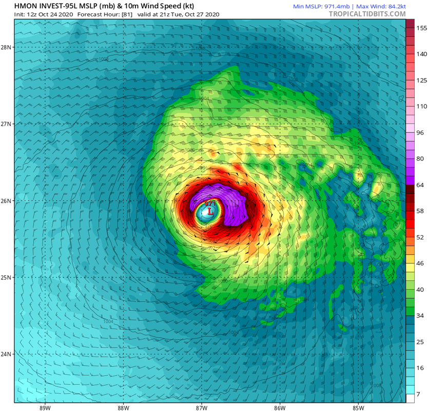
HMON much stronger. Down to 971MB at 81 hours heading NW into the Central Gulf.
0 likes
-
gatorcane
- S2K Supporter
- Posts: 23708
- Age: 48
- Joined: Sun Mar 13, 2005 3:54 pm
- Location: Boca Raton, FL
Re: ATL: INVEST 95L - Models
Blown Away wrote:12z HWRF much slower early on, might be more E long term.
Already more SW of the 06Z at 54 hours. Quite a ridge as models shift west within 36 hours.

0 likes
-
Blown Away
- S2K Supporter
- Posts: 10253
- Joined: Wed May 26, 2004 6:17 am
Re: ATL: INVEST 95L - Models
gatorcane wrote:HMON much stronger. Down to 971MB at 81 hours heading NW into the Central Gulf.
https://i.postimg.cc/MGd8yQ4B/hmon-mslp-wind-95-L-28.png
HMON continues with large SW shifts and continues to be the E outlier... Wouldn’t surprise me if these shifts continue and landfall into Yucatan and get trapped under HP... JMHO and it will take a few more runs to know... I’m not buying CGOM landfall...
2 likes
Hurricane Eye Experience: David 79, Irene 99, Frances 04, Jeanne 04, Wilma 05… Hurricane Brush Experience: Andrew 92, Erin 95, Floyd 99, Matthew 16, Irma 17, Ian 22, Nicole 22…
-
gatorcane
- S2K Supporter
- Posts: 23708
- Age: 48
- Joined: Sun Mar 13, 2005 3:54 pm
- Location: Boca Raton, FL
Re: ATL: INVEST 95L - Models
Blown Away wrote:gatorcane wrote:HMON much stronger. Down to 971MB at 81 hours heading NW into the Central Gulf.
https://i.postimg.cc/MGd8yQ4B/hmon-mslp-wind-95-L-28.png
HMON continues with large SW shifts and continues to be the E outlier... Wouldn’t surprise me if these shifts continue and landfall into Yucatan and get trapped under HP... JMHO and it will take a few more runs to know... I’m not buying CGOM landfall...
I am not buying CGOM also. If it happened with a Western or Central Gulf track, would be the first track like this so late in the season based on historical track data going back 150 years.
2 likes
-
cajungal

- Category 5

- Posts: 2354
- Age: 49
- Joined: Sun Mar 14, 2004 9:34 pm
- Location: Schriever, Louisiana (60 miles southwest of New Orleans)
Re: ATL: INVEST 95L - Models
gatorcane wrote:Blown Away wrote:gatorcane wrote:HMON much stronger. Down to 971MB at 81 hours heading NW into the Central Gulf.
https://i.postimg.cc/MGd8yQ4B/hmon-mslp-wind-95-L-28.png
HMON continues with large SW shifts and continues to be the E outlier... Wouldn’t surprise me if these shifts continue and landfall into Yucatan and get trapped under HP... JMHO and it will take a few more runs to know... I’m not buying CGOM landfall...
If it happened with a Western or Central Gulf track, would be the first track like this so late in the season based on historical track data going back 150 years.
Juan hit Oct 28th, 1985. Morgan city, La
3 likes
-
gatorcane
- S2K Supporter
- Posts: 23708
- Age: 48
- Joined: Sun Mar 13, 2005 3:54 pm
- Location: Boca Raton, FL
Re: ATL: INVEST 95L - Models
cajungal wrote:gatorcane wrote:Blown Away wrote:
HMON continues with large SW shifts and continues to be the E outlier... Wouldn’t surprise me if these shifts continue and landfall into Yucatan and get trapped under HP... JMHO and it will take a few more runs to know... I’m not buying CGOM landfall...
If it happened with a Western or Central Gulf track, would be the first track like this so late in the season based on historical track data going back 150 years.
Juan hit Oct 28th, 1985. Morgan city, La
But where Juan formed was nowhere close to where of 95l is expected to form.
0 likes
-
supercane4867
- Category 5
- Posts: 4966
- Joined: Wed Nov 14, 2012 10:43 am
Re: ATL: INVEST 95L - Models
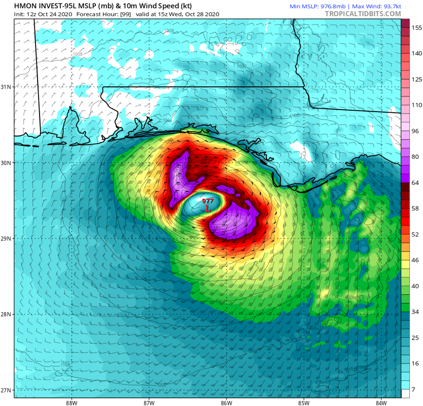
HWRF also much stronger in the Gulf. Pressure down to 977mb with winds up to 80kts by 81hr
0 likes
-
Stormcenter
- S2K Supporter
- Posts: 6689
- Joined: Wed Sep 03, 2003 11:27 am
- Location: Houston, TX
Re: ATL: INVEST 95L - Models
But then again it is 2020.
gatorcane wrote:Blown Away wrote:gatorcane wrote:HMON much stronger. Down to 971MB at 81 hours heading NW into the Central Gulf.
https://i.postimg.cc/MGd8yQ4B/hmon-mslp-wind-95-L-28.png
HMON continues with large SW shifts and continues to be the E outlier... Wouldn’t surprise me if these shifts continue and landfall into Yucatan and get trapped under HP... JMHO and it will take a few more runs to know... I’m not buying CGOM landfall...
I am not buying CGOM also. If it happened with a Western or Central Gulf track, would be the first track like this so late in the season based on historical track data going back 150 years.
2 likes
-
SouthFLTropics

- Category 5
- Posts: 4258
- Age: 50
- Joined: Thu Aug 14, 2003 8:04 am
- Location: Port St. Lucie, Florida
Re: ATL: INVEST 95L - Models
Based on the mess we are seeing on visible, I believe we are going to continue to see center reformations all over the place. Until this consolidates and a dominate center takes over, the models are for the most part throwing darts blindfolded. JMHO.
6 likes
Fourth Generation Florida Native
Personal Storm History: David 79, Andrew 92, Erin 95, Floyd 99, Irene 99, Frances 04, Jeanne 04, Wilma 05, Matthew 16, Irma 17, Ian 22, Nicole 22, Milton 24
Personal Storm History: David 79, Andrew 92, Erin 95, Floyd 99, Irene 99, Frances 04, Jeanne 04, Wilma 05, Matthew 16, Irma 17, Ian 22, Nicole 22, Milton 24
-
Emmett_Brown

- Category 5
- Posts: 1433
- Joined: Wed Aug 24, 2005 9:10 pm
- Location: Sarasota FL
Re: ATL: INVEST 95L - Models
12Z HWRF has shifted E, landfalling in the W FL Panhandle, stronger than 6Z, but weakening upon approach. No doubt further shifts to come in future runs.
0 likes
Re: ATL: INVEST 95L - Models
12Z Euro: high end TS to cat 1 H into C LA late 10/28, which is 300 miles w of UK but UK is much later with LF 24 hours later than Euro at Destin:

Last edited by LarryWx on Sat Oct 24, 2020 1:26 pm, edited 1 time in total.
0 likes
Personal Forecast Disclaimer:
The posts in this forum are NOT official forecasts and should not be used as such. They are just the opinion of the poster and may or may not be backed by sound meteorological data. They are NOT endorsed by any professional institution or storm2k.org. For official information, please refer to the NHC and NWS products.
The posts in this forum are NOT official forecasts and should not be used as such. They are just the opinion of the poster and may or may not be backed by sound meteorological data. They are NOT endorsed by any professional institution or storm2k.org. For official information, please refer to the NHC and NWS products.
-
Blown Away
- S2K Supporter
- Posts: 10253
- Joined: Wed May 26, 2004 6:17 am
Re: ATL: INVEST 95L - Models
Ok, enough. The 12z Euro sends 95L into TX/LA border area as a TS /Cat 1 in 5 days... I’m making the call, center reformation to the SW, trapped under HP in NW Caribbean and/or over Yucatan and ultimately a NE ejection towards FL peninsula in 5-7 days... 
0 likes
Hurricane Eye Experience: David 79, Irene 99, Frances 04, Jeanne 04, Wilma 05… Hurricane Brush Experience: Andrew 92, Erin 95, Floyd 99, Matthew 16, Irma 17, Ian 22, Nicole 22…
-
Loveweather12
- Tropical Storm

- Posts: 136
- Joined: Thu Aug 20, 2020 2:37 pm
Re: ATL: INVEST 95L - Models
Blown Away wrote:Ok, enough. The 12z Euro sends 95L into TX/LA border area as a TS /Cat 1 in 5 days... I’m making the call, center reformation to the SW, trapped under HP in NW Caribbean and/or over Yucatan and ultimately a NE ejection towards FL peninsula in 5-7 days...
Interested to hear as to why you think that might happen. Thank you for your analysis
0 likes
-
gatorcane
- S2K Supporter
- Posts: 23708
- Age: 48
- Joined: Sun Mar 13, 2005 3:54 pm
- Location: Boca Raton, FL
Re: ATL: INVEST 95L - Models
LarryWx wrote:12Z Euro: high end TS to cat 1 H into C LA late 10/28, which is 300 miles w of UK but UK is much later with LF 24 hours later than Euro at Destin:
https://i.imgur.com/aYjT5Vh.png
Similar area to where Laura and Delta hit, a bit more east. That area just can’t catch a break.
0 likes

Re: ATL: INVEST 95L - Models
gatorcane wrote:LarryWx wrote:12Z Euro: high end TS to cat 1 H into C LA late 10/28, which is 300 miles w of UK but UK is much later with LF 24 hours later than Euro at Destin:
https://i.imgur.com/aYjT5Vh.png
Similar area to where Laura and Delta hit, a bit more east. That area just can’t catch a break.
Doubtful.
We have cold fronts forecast to be moving through in that timeframe.
0 likes
-
Blown Away
- S2K Supporter
- Posts: 10253
- Joined: Wed May 26, 2004 6:17 am
Re: ATL: INVEST 95L - Models
Loveweather12 wrote:Blown Away wrote:Ok, enough. The 12z Euro sends 95L into TX/LA border area as a TS /Cat 1 in 5 days... I’m making the call, center reformation to the SW, trapped under HP in NW Caribbean and/or over Yucatan and ultimately a NE ejection towards FL peninsula in 5-7 days...
Interested to hear as to why you think that might happen. Thank you for your analysis
Mostly climatology based. So rare for a late October storm to move NW from Caribbean to CGOM landfall. My thinking is a center reforms a few degrees SW of current spot and steering currents weaken and 95L sits until strong trough in about 6 days pulls 95L out of Caribbean and kicks him NE. Another scenario is bury into Yucatan. Don’t listen to me, go w/ the NHC...
1 likes
Hurricane Eye Experience: David 79, Irene 99, Frances 04, Jeanne 04, Wilma 05… Hurricane Brush Experience: Andrew 92, Erin 95, Floyd 99, Matthew 16, Irma 17, Ian 22, Nicole 22…

Re: ATL: INVEST 95L - Models
Salute!
Actually, blown, the fronts have saved many of us in the Panhandle.
I like your model.
Gums sends...
Actually, blown, the fronts have saved many of us in the Panhandle.
I like your model.
Gums sends...
0 likes
-
cp79
Re: ATL: INVEST 95L - Models
The only way central or So.Florida gets affected is if it gets trapped by the HP like Mitch did and sits in the Caribbean for 3 days. Then the front comes in mid-week and pushes it NE. Other than that, HP will block a system from going to Fla for the next few days. HP over Fla has seemingly sat over the state for the last 10 weeks and keeps blocking systems from heading that direction.
1 likes
Who is online
Users browsing this forum: No registered users and 19 guests