ATL: DELTA - Post-Tropical - Discussion
Moderator: S2k Moderators

Re: ATL: DELTA - Hurricane - Discussion
Looking at RECON, yeah the max winds might of gone down, but looks like the TS winds have expanded even further, which is expected with the eye growing in size from a pinhole eye.
0 likes
Personal Forecast Disclaimer:
The posts in this forum are NOT official forecast and should not be used as such. They are just the opinion of the poster and may or may not be backed by sound meteorological data. They are NOT endorsed by any professional institution or storm2k.org. For official information, please refer to the NHC and NWS products.
The posts in this forum are NOT official forecast and should not be used as such. They are just the opinion of the poster and may or may not be backed by sound meteorological data. They are NOT endorsed by any professional institution or storm2k.org. For official information, please refer to the NHC and NWS products.
-
CrazyC83
- Professional-Met

- Posts: 34311
- Joined: Tue Mar 07, 2006 11:57 pm
- Location: Deep South, for the first time!
Re: ATL: DELTA - Hurricane - Discussion
Blinhart wrote:Looking at RECON, yeah the max winds might of gone down, but looks like the TS winds have expanded even further, which is expected with the eye growing in size from a pinhole eye.
The pressure gradient is thinning out too.
2 likes
Re: ATL: DELTA - Hurricane - Discussion
CrazyC83 wrote:Blinhart wrote:Looking at RECON, yeah the max winds might of gone down, but looks like the TS winds have expanded even further, which is expected with the eye growing in size from a pinhole eye.
The pressure gradient is thinning out too.
Important points with regards to a broader wind field causing more land effects. SFMR is higher this time, around 90 kt. Lets wait for the NW side.
0 likes
-
AJC3

- Admin

- Posts: 4152
- Age: 62
- Joined: Tue Aug 31, 2004 7:04 pm
- Location: Ballston Spa, New York
- Contact:
Re: ATL: DELTA - Hurricane - Discussion
Steve wrote: Thanks on that. But we usually see harsher weakening effects when the shear is coming at a sharper angle unless that’s just anecdotal from watching storms come up in the Gulf. We just saw the effects from the other direction on Gamma. I do get the different levels as we see that in the winter sometimes here in the clouds. So is it that the direction of the shear doesn’t matter at all?
The factors that determine how destructive shear is to a TC are threefold:
1) Its magnitude (how strong it is, obviously)
2) Whether or not the shear is accompanied by low RH air that can punch into the core
3) Whether it is convergent (worse), neutral (bad), or divergent (not as bad)
I often see discussions which mention that a tropical cyclone moving with the shear vector won't be impacted as negatively. TBH, I'm not 100 percent sure why this is the case. I think it has to be one of two things:
TC Dynamics? Perhaps studies have shown that when a storm is moving with the shear vector (or moving downshear), there may be some modest mitigation, simply due to the fact that the storm is "trying" to move toward the sheared convection with time, while the opposite is true when a storm is moving into the shear vector. After all, a well-developed tropical cyclone will attempt to maintain vertical coherence of its circulation, which is why you see centers "jump" or get pulled back underneath sheared CDOs, even when the lower level contrbution to the steering flow is trying to drive the LLCC in a different direction. Or, perhaps from a synoptic setup, shear which occurs with the storm motion vector may have been statistically shown to be divergent more often than not.
Bias? On the other hand, maybe shear calculations for storms moving with the shear vector have been statistically shown to be erroneously high?
But again, when you go by the vector math...shear calculations are what they are. The important point I wanted to emphasize is that the lower level wind has already been taken into account in terms of shear. A great way to check to see if the CIMSS wind shear fields near a TC are accurate is simply to take the storm motion vector in the advisory and compare it to the environmental wind at 200, 250mb, ..., 500mb, etc. This can get tough up around the troposphere for a well developed TC, since the analyzed wind fields over the top of it have some contamination from the anticyclonic wind field generated by the TC itself. Sometimes you have to look more at the peripheral winds just outside this to get a better feel.
edit: I probably should add that the shear level is also a factor, given that mid level shear is generally thought to be more hostile for a TC than upper tropospheric shear is
13 likes
-
stormhunter7

- Category 2

- Posts: 763
- Joined: Mon May 26, 2008 3:13 pm
- Location: Panama City Beach, Florida
- Contact:
Re: ATL: DELTA - Hurricane - Discussion
I feel a type of Fujiwhara effect has started with Delta this afternoon? Due the left overs of Gamma.
1 likes
The following post is NOT an official forecast and should not be used as such. It is just the opinion of the poster and may or may not be backed by sound meteorological data. It is NOT endorsed by any professional institution including storm2k.org For Official Information please refer to the NHC and NWS products. http://www.nhc.noaa.gov
-
CrazyC83
- Professional-Met
- Posts: 34311
- Joined: Tue Mar 07, 2006 11:57 pm
- Location: Deep South, for the first time!
Re: ATL: DELTA - Hurricane - Discussion
wx98 wrote:CrazyC83 wrote:Blinhart wrote:Looking at RECON, yeah the max winds might of gone down, but looks like the TS winds have expanded even further, which is expected with the eye growing in size from a pinhole eye.
The pressure gradient is thinning out too.
Important points with regards to a broader wind field causing more land effects. SFMR is higher this time, around 90 kt. Lets wait for the NW side.
That 90 kt SFMR is likely in the remnants of the tiny eyewall.
2 likes
-
Keldeo1997
- Category 2
- Posts: 688
- Joined: Fri Oct 11, 2019 11:35 pm

Re: ATL: DELTA - Hurricane - Discussion
High probability it will not move any farther west. This is according to a local met. Apparently the west trend in the models has stopped. We’ll see though.Blow_Hard wrote:texsn95 wrote:bella_may wrote:Good chance this alters the track
In which direction?
I'm no Met but my guess would be we could see yet more west shifts to the track.
0 likes
-
stormhunter7
- Category 2
- Posts: 763
- Joined: Mon May 26, 2008 3:13 pm
- Location: Panama City Beach, Florida
- Contact:
Re: ATL: DELTA - Hurricane - Discussion
Was thinking we have a direct hit this evening... But looks like it Delta will pass just south of 42506
https://www.ndbc.noaa.gov/station_page. ... tion=42056
https://www.ndbc.noaa.gov/station_page. ... tion=42056
0 likes
The following post is NOT an official forecast and should not be used as such. It is just the opinion of the poster and may or may not be backed by sound meteorological data. It is NOT endorsed by any professional institution including storm2k.org For Official Information please refer to the NHC and NWS products. http://www.nhc.noaa.gov
-
Stormgodess

- Category 1

- Posts: 316
- Joined: Mon Sep 14, 2020 1:31 am
Re: ATL: DELTA - Hurricane - Discussion
Just putting this out there... For laymen, and the general public, Inconsistent images like these, are so frustrating. They get passed around on social media...Which sadly is where many get news, and that is what people go by.
These images are all from 7:00pm Central updates, from two stations both located in New Orleans. Can you imagine how confusing images like this are to the general public?
https://i.postimg.cc/JzPjW9pT/Full-Delta.png
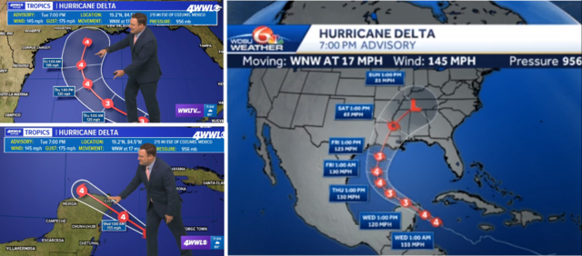
These images are all from 7:00pm Central updates, from two stations both located in New Orleans. Can you imagine how confusing images like this are to the general public?
https://i.postimg.cc/JzPjW9pT/Full-Delta.png
1 likes
Re: ATL: DELTA - Hurricane - Discussion
They brought it down some:
10:00 PM CDT Tue Oct 6
Location: 19.5°N 85.1°W
Moving: WNW at 16 mph
Min pressure: 960 mb
Max sustained: 130 mph
Location: 19.5°N 85.1°W
Moving: WNW at 16 mph
Min pressure: 960 mb
Max sustained: 130 mph
0 likes
-
CrazyC83
- Professional-Met
- Posts: 34311
- Joined: Tue Mar 07, 2006 11:57 pm
- Location: Deep South, for the first time!
Re: ATL: DELTA - Hurricane - Discussion
wx98 wrote:They brought it down some:10:00 PM CDT Tue Oct 6
Location: 19.5°N 85.1°W
Moving: WNW at 16 mph
Min pressure: 960 mb
Max sustained: 130 mph
That is still very generous.
1 likes
-
ElectricStorm

- Category 5

- Posts: 5124
- Age: 24
- Joined: Tue Aug 13, 2019 11:23 pm
- Location: Norman, OK
Re: ATL: DELTA - Hurricane - Discussion
wx98 wrote:They brought it down some:10:00 PM CDT Tue Oct 6
Location: 19.5°N 85.1°W
Moving: WNW at 16 mph
Min pressure: 960 mb
Max sustained: 130 mph
Hmm I thought they would go lower but I guess not... They are the experts. Just doesn't seem like a cat 4 to me right now
0 likes
B.S Meteorology, University of Oklahoma '25
Please refer to the NHC, NWS, or SPC for official information.
Please refer to the NHC, NWS, or SPC for official information.
Re: ATL: DELTA - Hurricane - Discussion
CrazyC83 wrote:wx98 wrote:They brought it down some:10:00 PM CDT Tue Oct 6
Location: 19.5°N 85.1°W
Moving: WNW at 16 mph
Min pressure: 960 mb
Max sustained: 130 mph
That is still very generous.
They mention their generosity in the discussion:
Hurricane Delta Discussion Number 10
NWS National Hurricane Center Miami FL AL262020
1000 PM CDT Tue Oct 06 2020
Observations from a NOAA Hurricane Hunter aircraft and conventional
and microwave satellite imagery indicate that Delta has not
intensified since earlier today. The central pressure has risen
somewhat and the current intensity estimate, 115 kt, is probably
generous based on flight-level and SFMR-observed surface winds from
the NOAA plane. Although the hurricane continues to have very deep
convection near and over the center, the cloud pattern lacks
well-defined banding features, and an eye is not evident on either
geostationary or polar-orbiting satellite images. Surveillance
data from the NOAA G-IV aircraft suggest that Delta's circulation
does not extend as markedly into the upper troposphere as one would
expect for a major hurricane. Given the current state of the
system, not much strengthening seems likely before the center
reaches northeastern Yucatan tomorrow morning. Some weakening is
likely due to the interaction with land during the next 12-18
hours.
0 likes
-
CrazyC83
- Professional-Met
- Posts: 34311
- Joined: Tue Mar 07, 2006 11:57 pm
- Location: Deep South, for the first time!
Re: ATL: DELTA - Hurricane - Discussion
Regardless of its exact intensity, any winds of strong hurricane force are VERY dangerous and will do severe damage. Look what Sally did and it wasn't a major hurricane.
6 likes
Re: ATL: DELTA - Hurricane - Discussion
Weather Dude wrote:wx98 wrote:They brought it down some:10:00 PM CDT Tue Oct 6
Location: 19.5°N 85.1°W
Moving: WNW at 16 mph
Min pressure: 960 mb
Max sustained: 130 mph
Hmm I thought they would go lower but I guess not... They are the experts. Just doesn't seem like a cat 4 to me right now
Sounds like they believe it is weaker based on the discussion, but they probably don't want to drop way down and risk it intensifying again unexpectedly.
4 likes
-
ElectricStorm
- Category 5
- Posts: 5124
- Age: 24
- Joined: Tue Aug 13, 2019 11:23 pm
- Location: Norman, OK
Re: ATL: DELTA - Hurricane - Discussion
wx98 wrote:Weather Dude wrote:wx98 wrote:They brought it down some:10:00 PM CDT Tue Oct 6
Location: 19.5°N 85.1°W
Moving: WNW at 16 mph
Min pressure: 960 mb
Max sustained: 130 mph
Hmm I thought they would go lower but I guess not... They are the experts. Just doesn't seem like a cat 4 to me right now
Sounds like they believe it is weaker based on the discussion, but they probably don't want to drop way down and risk it intensifying again unexpectedly.
Yeah that makes sense. Still will be destructive no matter what category it is. Still a long way to go
2 likes
B.S Meteorology, University of Oklahoma '25
Please refer to the NHC, NWS, or SPC for official information.
Please refer to the NHC, NWS, or SPC for official information.
-
SconnieCane
- Category 5
- Posts: 1013
- Joined: Thu Aug 02, 2018 5:29 pm
- Location: Madison, WI
Re: ATL: DELTA - Hurricane - Discussion
CrazyC83 wrote:Regardless of its exact intensity, any winds of strong hurricane force are VERY dangerous and will do severe damage. Look what Sally did and it wasn't a major hurricane.
True, but you really don't get to the frame-house-ripping-apart, wind alone can kill you in your shelter stuff until the upper end of Category 4, and that mostly with the gusts into the 5 range. It's only the very rare storms like Andrew that can do that over a relatively large area of the core's path.
1 likes
-
MississippiWx

- S2K Supporter

- Posts: 1720
- Joined: Sat Aug 14, 2010 1:44 pm
- Location: Hattiesburg, Mississippi
Re: ATL: DELTA - Hurricane - Discussion
The flattening of the eastern half of the CDO warned us earlier that shear was on the increase. Not long after this occurred, Delta's core collapsed.
The eastern semicircle is becoming more rounded now which means shear is probably beginning to let up some. I think Delta will start strengthening slowly again right until landfall.
The eastern semicircle is becoming more rounded now which means shear is probably beginning to let up some. I think Delta will start strengthening slowly again right until landfall.
6 likes
This post is not an official forecast and should not be used as such. It is just the opinion of MississippiWx and may or may not be backed by sound meteorological data. It is not endorsed by any professional institution including storm2k.org. For Official Information please refer to the NHC and NWS products.
Who is online
Users browsing this forum: No registered users and 22 guests