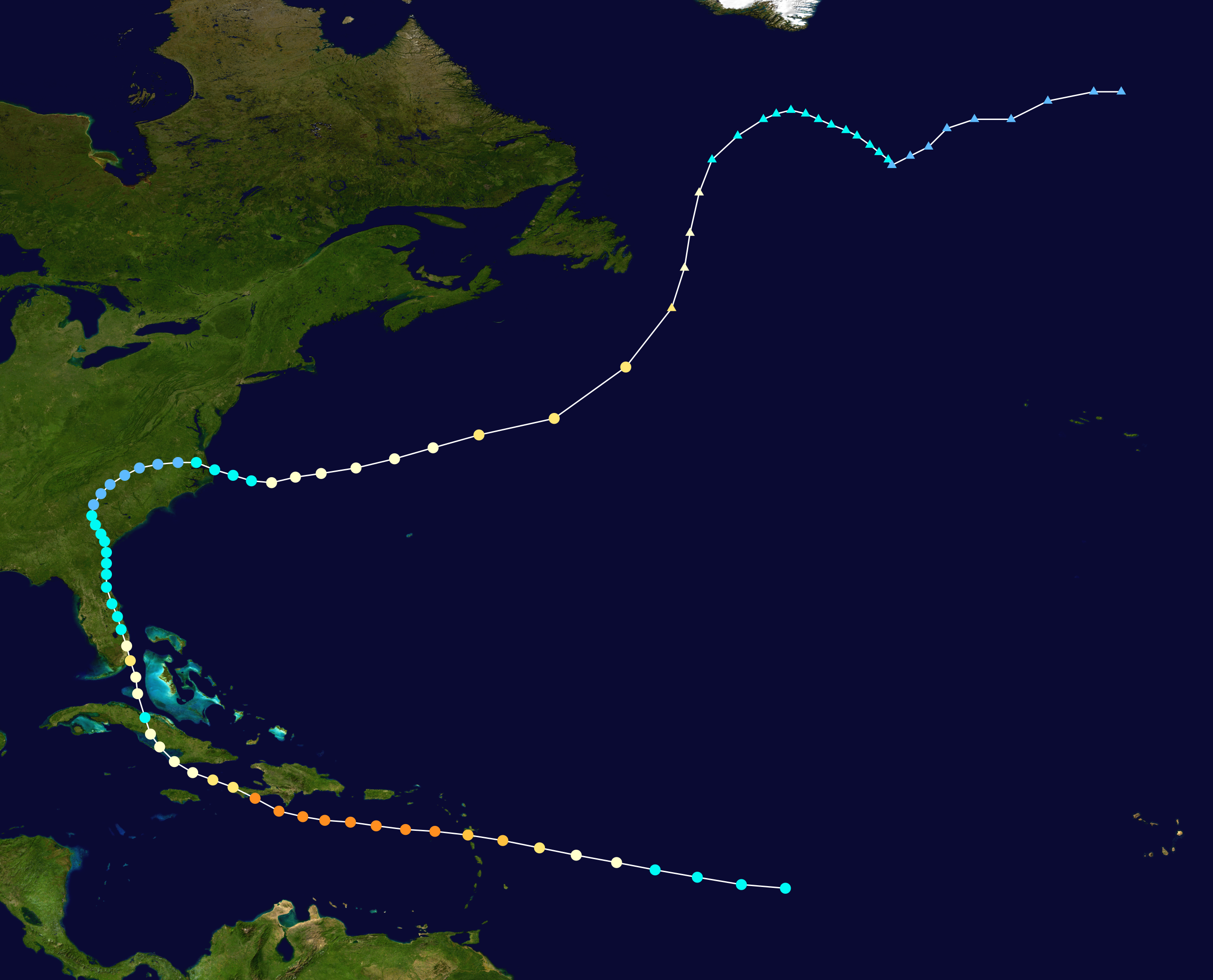
CourierPR wrote:I wonder if this will take a path similar to Hurricane Cleo in 1964, which crossed the mountains of eastern Cuba and then continued up the Florida east coast.
Moderator: S2k Moderators
CourierPR wrote:I wonder if this will take a path similar to Hurricane Cleo in 1964, which crossed the mountains of eastern Cuba and then continued up the Florida east coast.


supercane4867 wrote:https://i.imgur.com/78zsapp.gif
CaribJam wrote:Can a pro explain this extract from the discussion for me, please:
More recently, a band has
developed over the southwestern portion of the broad circulation
and it appears that the system may be closer to acquiring a
well-defined center
Are they hinting/suggesting that the "centre" may be forming to the southwest? And what influence will this have on the short-term movement of the system, especially for us in the Central Caribbean?
Thanks


psyclone wrote:aspen wrote:If the new NHC cone verifies, PTC-9/Isaias will have 18-24 hours over warm (29-30 C) waters before making landfall in southern Florida. However, the degree of windshield wiping with the models and official forecast cone, along with the high uncertainty in the exact location of the center of the system, make it unlikely that Isaias’ actual track will be like this.
Either side of Florida has its ups and downs for future Isaias. To the east, it could take advantage of the extremely high Gulf Stream SSTs, but it would have to fight against a trough imparting shear on it. To the west, Isaias could avoid the trough (from what I’ve heard), but the waters in the eastern Gulf, while warm, are quite shallow and recently disturbed.
They are shallow...and less warm compared to a couple weeks ago...but they are plenty warm for a transiting storm. every bit as warm if not warmer than the shelf waters that enabled Michael to attain cat 5 status on approach to the panhandle in 2018.. mid to upper 80's. If the system struggles it won't be for lack of warm water around florida.
NDG wrote:TheStormExpert wrote:NDG wrote:If the system indeed takes the persistent track that the Euro has been forecasting run after run, north of Cuba, whoever thinks is going to have SW shear to deal with is lying to themselves. With the trough axis all the way west over the MS river valley it should have fairly good UL conditions.
Remember how bad they were with the intensity of Hanna 2-3 days before making landfall.
Any idea or guess on where PTC-9 may end up or go with that trough?
It all depends what kind of a shape it is after leaves Hispaniola and if the narrow ridge to the north weakens or stays strong, tomorrow we should have a better idea of its tracks, just east of FL, over FL or along the west coast of FL.


CM2 wrote:CaribJam wrote:Can a pro explain this extract from the discussion for me, please:
More recently, a band has
developed over the southwestern portion of the broad circulation
and it appears that the system may be closer to acquiring a
well-defined center
Are they hinting/suggesting that the "centre" may be forming to the southwest? And what influence will this have on the short-term movement of the system, especially for us in the Central Caribbean?
Thanks
If it's further south, then that means the general path of the storm will also be further south, though because it's a big storm it isn't gonna rapidly intensify anytime soon. We don't really know where the storm is going because the models are initializing it about 70-80 miles north of where it probabaly actually is. Though worse case you end up with some sloppy tropical storm weather. I don't think there is any doubt the greater antilles are not gonna recive anything more than a TS at worse. The main concern for a hurricane in any capacity is mainly the Bahamas and the US.


ScottNAtlanta wrote:It almost does look like 2 systems rotating around each other on the wider (2mile) view. We will know for sure this time tomorrow (I know I said ask me Wed...but it is still Wed till 11:59 pm). Is the next recon later tonight like it was yesterday?


Hammy wrote:Are we getting another flight this evening?
Jr0d wrote:I still think that Hispaniola could split the wave, with the south 'vortex' continuing on a more west track and the other half taking a more NW track. The wave axis is certainly large enough to spawn two systems.
Even if this does not happen, the system is too broad to be shredded to nothing by Hispaniola, in my amateur opinion.
Users browsing this forum: No registered users and 36 guests


