PTC next advisory?
1. A tropical wave located over the central Caribbean Sea continues to
produce a large area of showers and thunderstorms. This system has
become a little better organized during the past several hours.
Additional development is expected, and a tropical depression will
likely form within the next day or two as it moves slowly westward
over the central and western Caribbean Sea. Interests in Honduras
and Nicaragua should closely monitor the progress of this system.
Regardless of development, this disturbance is expected to bring
heavy rainfall along with possible flash flooding to portions of
Hispaniola over the next day or so. For more detailed information,
refer to products issued by your local weather office.
* Formation chance through 48 hours...high...90 percent.
* Formation chance through 5 days...high...90 percent.
ATL: IOTA - Remnants - Discussion
Moderator: S2k Moderators
-
ElectricStorm

- Category 5

- Posts: 5140
- Age: 25
- Joined: Tue Aug 13, 2019 11:23 pm
- Location: Norman, OK
Re: ATL: INVEST 98L - Discussion
0 likes
B.S Meteorology, University of Oklahoma '25
Please refer to the NHC, NWS, or SPC for official information.
Please refer to the NHC, NWS, or SPC for official information.

Re: ATL: INVEST 98L - Discussion
Weather Dude wrote:PTC next advisory?
Doubt it. PTCs are only used if watches or warnings need to be issued before the cyclone has formed. Since no land areas are likely to experience TS winds in 48 hours, I don't see the need.
3 likes

-
Keldeo1997
- Category 2

- Posts: 688
- Joined: Fri Oct 11, 2019 11:35 pm

-
Iceresistance

- Category 5
- Posts: 9579
- Age: 22
- Joined: Sat Oct 10, 2020 9:45 am
- Location: Tecumseh, OK/Norman, OK
Re: ATL: INVEST 98L - Discussion
Owasso wrote:https://i.postimg.cc/HxBSC0nj/79322478.gif
Big towers!
1 likes
Bill 2015 & Beta 2020
Winter 2020-2021
All observations are in Tecumseh, OK unless otherwise noted.
Winter posts are focused mainly for Oklahoma & Texas.
Take any of my forecasts with a grain of salt, refer to the NWS, SPC, and NHC for official information
Never say Never with weather! Because ANYTHING is possible!
Winter 2020-2021
All observations are in Tecumseh, OK unless otherwise noted.
Winter posts are focused mainly for Oklahoma & Texas.
Take any of my forecasts with a grain of salt, refer to the NWS, SPC, and NHC for official information
Never say Never with weather! Because ANYTHING is possible!
-
Iceresistance
- Category 5
- Posts: 9579
- Age: 22
- Joined: Sat Oct 10, 2020 9:45 am
- Location: Tecumseh, OK/Norman, OK
Re: ATL: INVEST 98L - Discussion
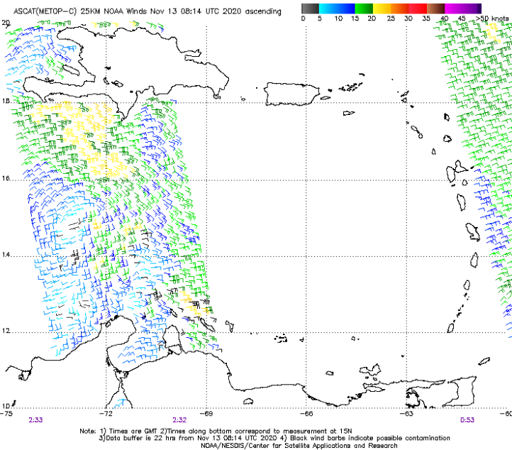
When is the next ASCAT pass?
0 likes
Bill 2015 & Beta 2020
Winter 2020-2021
All observations are in Tecumseh, OK unless otherwise noted.
Winter posts are focused mainly for Oklahoma & Texas.
Take any of my forecasts with a grain of salt, refer to the NWS, SPC, and NHC for official information
Never say Never with weather! Because ANYTHING is possible!
Winter 2020-2021
All observations are in Tecumseh, OK unless otherwise noted.
Winter posts are focused mainly for Oklahoma & Texas.
Take any of my forecasts with a grain of salt, refer to the NWS, SPC, and NHC for official information
Never say Never with weather! Because ANYTHING is possible!


Re: ATL: INVEST 98L - Discussion
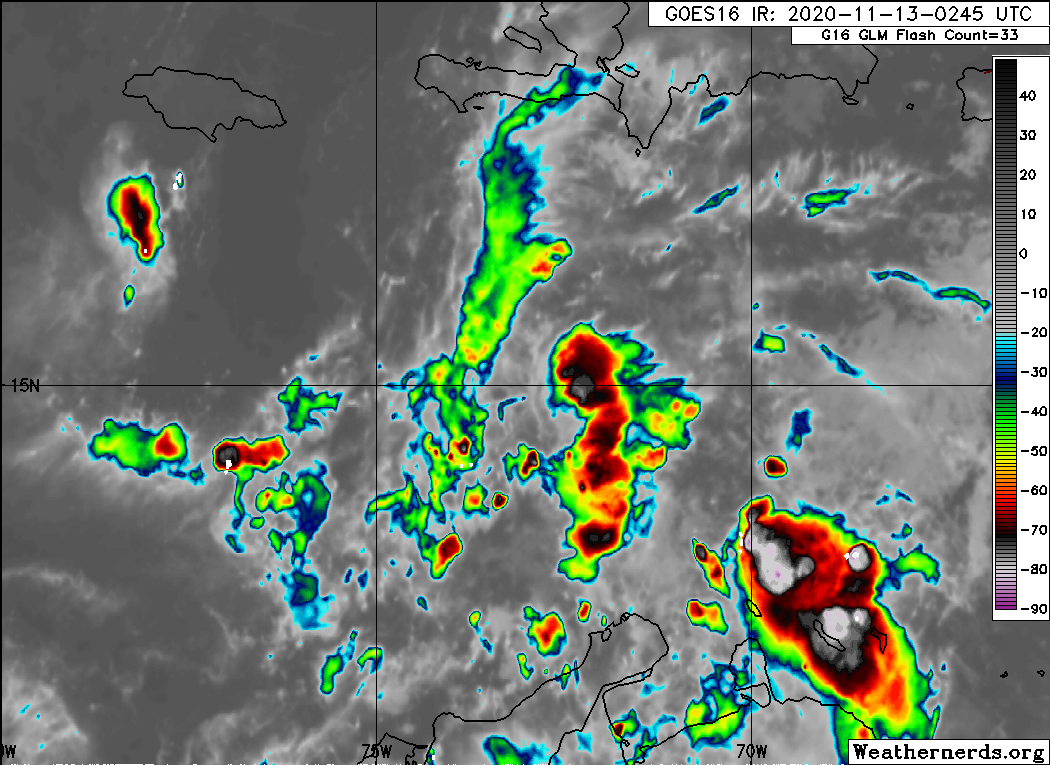
Difficult as it is making out low level flow from night-time satellite, it seems appearant to me that a LLC is becoming organized between 14N-15N on the northern edge of deeper convection that is presently firing up. I'm anticipating that NHC will tag this a T.D. sometime between late morning and afternoon today.
2 likes
Andy D
(For official information, please refer to the NHC and NWS products.)
(For official information, please refer to the NHC and NWS products.)
-
cycloneye

- Admin

- Posts: 149275
- Age: 69
- Joined: Thu Oct 10, 2002 10:54 am
- Location: San Juan, Puerto Rico
Re: ATL: INVEST 98L - Discussion
8 AM: TD or TS to form later today or tonight.
Showers and thunderstorms associated with a broad area of low
pressure over the central Caribbean Sea have increased and become
better organized since yesterday. Environmental conditions are
conducive for additional development, and a tropical depression or
tropical storm is likely to form later today or tonight while the
system moves slowly westward. Additional development of the
system is likely over the weekend, and interests in Honduras and
Nicaragua should closely monitor the progress of the disturbance.
* Formation chance through 48 hours...high...90 percent.
* Formation chance through 5 days...high...90 percent.
0 likes
Visit the Caribbean-Central America Weather Thread where you can find at first post web cams,radars
and observations from Caribbean basin members Click Here
and observations from Caribbean basin members Click Here

Re: ATL: INVEST 98L - Discussion
cycloneye wrote:8 AM: TD or TS to form later today or tonight.Showers and thunderstorms associated with a broad area of low
pressure over the central Caribbean Sea have increased and become
better organized since yesterday. Environmental conditions are
conducive for additional development, and a tropical depression or
tropical storm is likely to form later today or tonight while the
system moves slowly westward. Additional development of the
system is likely over the weekend, and interests in Honduras and
Nicaragua should closely monitor the progress of the disturbance.
* Formation chance through 48 hours...high...90 percent.
* Formation chance through 5 days...high...90 percent.
I hope that means we’re getting a PTC next advisory.
0 likes
Irene '11 Sandy '12 Hermine '16 5/15/2018 Derecho Fay '20 Isaias '20 Elsa '21 Henri '21 Ida '21
I am only a meteorology enthusiast who knows a decent amount about tropical cyclones. Look to the professional mets, the NHC, or your local weather office for the best information.
I am only a meteorology enthusiast who knows a decent amount about tropical cyclones. Look to the professional mets, the NHC, or your local weather office for the best information.
-
cycloneye
- Admin
- Posts: 149275
- Age: 69
- Joined: Thu Oct 10, 2002 10:54 am
- Location: San Juan, Puerto Rico
Re: ATL: INVEST 98L - Discussion
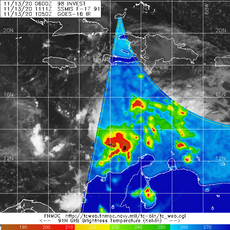
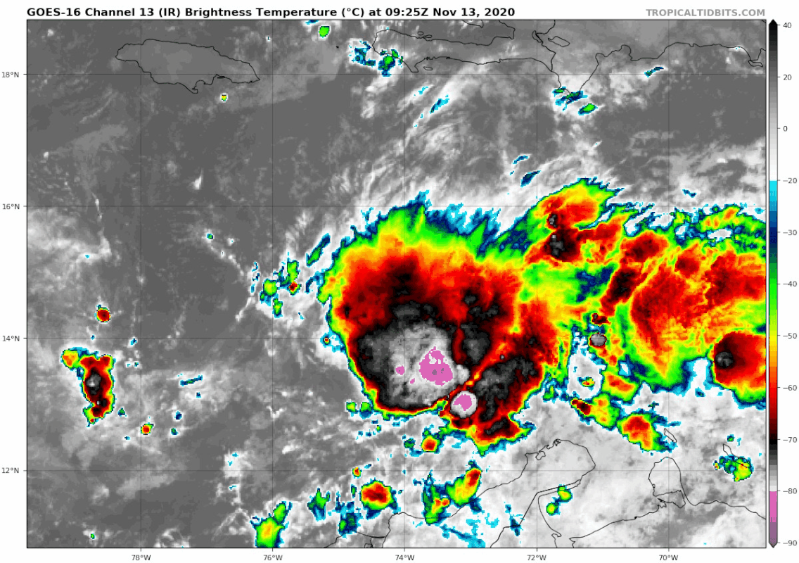
Owasso wrote:https://i.postimg.cc/wxG6PF4y/image.png
Looks to be more south than the past best track position of 14.9N so expect the 12z to be more south. If this holds,then it will make landfall in Nicaragua sooner and not get a lot of ACE.
2 likes
Visit the Caribbean-Central America Weather Thread where you can find at first post web cams,radars
and observations from Caribbean basin members Click Here
and observations from Caribbean basin members Click Here
-
cycloneye
- Admin
- Posts: 149275
- Age: 69
- Joined: Thu Oct 10, 2002 10:54 am
- Location: San Juan, Puerto Rico
Re: ATL: INVEST 98L - Discussion
More south and up to 30kts and 1007 mbs.
98L INVEST 201113 1200 14.3N 74.0W ATL 30 1007
2 likes
Visit the Caribbean-Central America Weather Thread where you can find at first post web cams,radars
and observations from Caribbean basin members Click Here
and observations from Caribbean basin members Click Here
-
Iceresistance
- Category 5
- Posts: 9579
- Age: 22
- Joined: Sat Oct 10, 2020 9:45 am
- Location: Tecumseh, OK/Norman, OK
Re: ATL: INVEST 98L - Discussion
cycloneye wrote:More south and up to 30kts and 1007 mbs.98L INVEST 201113 1200 14.3N 74.0W ATL 30 1007
getting stronger
0 likes
Bill 2015 & Beta 2020
Winter 2020-2021
All observations are in Tecumseh, OK unless otherwise noted.
Winter posts are focused mainly for Oklahoma & Texas.
Take any of my forecasts with a grain of salt, refer to the NWS, SPC, and NHC for official information
Never say Never with weather! Because ANYTHING is possible!
Winter 2020-2021
All observations are in Tecumseh, OK unless otherwise noted.
Winter posts are focused mainly for Oklahoma & Texas.
Take any of my forecasts with a grain of salt, refer to the NWS, SPC, and NHC for official information
Never say Never with weather! Because ANYTHING is possible!
Re: ATL: INVEST 98L - Discussion
cycloneye wrote:Owasso wrote:https://i.postimg.cc/wxG6PF4y/image.png
Looks to be more south than the past best track position of 14.9N so expect the 12z to be more south. If this holds,then it will make landfall in Nicaragua sooner and not get a lot of ACE.
Yeah, the center most likely got pulled SE into the heavier convection.
2 likes
-
Iceresistance
- Category 5
- Posts: 9579
- Age: 22
- Joined: Sat Oct 10, 2020 9:45 am
- Location: Tecumseh, OK/Norman, OK
Re: ATL: INVEST 98L - Discussion
cycloneye wrote:Owasso wrote:https://i.postimg.cc/wxG6PF4y/image.png
Looks to be more south than the past best track position of 14.9N so expect the 12z to be more south. If this holds,then it will make landfall in Nicaragua sooner and not get a lot of ACE.
But what if 98L explodes like Eta did?
0 likes
Bill 2015 & Beta 2020
Winter 2020-2021
All observations are in Tecumseh, OK unless otherwise noted.
Winter posts are focused mainly for Oklahoma & Texas.
Take any of my forecasts with a grain of salt, refer to the NWS, SPC, and NHC for official information
Never say Never with weather! Because ANYTHING is possible!
Winter 2020-2021
All observations are in Tecumseh, OK unless otherwise noted.
Winter posts are focused mainly for Oklahoma & Texas.
Take any of my forecasts with a grain of salt, refer to the NWS, SPC, and NHC for official information
Never say Never with weather! Because ANYTHING is possible!
-
Iceresistance
- Category 5
- Posts: 9579
- Age: 22
- Joined: Sat Oct 10, 2020 9:45 am
- Location: Tecumseh, OK/Norman, OK
Re: ATL: INVEST 98L - Discussion
Saved loop of 98L, look at that CDO

0 likes
Bill 2015 & Beta 2020
Winter 2020-2021
All observations are in Tecumseh, OK unless otherwise noted.
Winter posts are focused mainly for Oklahoma & Texas.
Take any of my forecasts with a grain of salt, refer to the NWS, SPC, and NHC for official information
Never say Never with weather! Because ANYTHING is possible!
Winter 2020-2021
All observations are in Tecumseh, OK unless otherwise noted.
Winter posts are focused mainly for Oklahoma & Texas.
Take any of my forecasts with a grain of salt, refer to the NWS, SPC, and NHC for official information
Never say Never with weather! Because ANYTHING is possible!
-
Nancy Smar

- Category 5
- Posts: 1081
- Age: 25
- Joined: Wed Aug 16, 2017 10:03 pm
Who is online
Users browsing this forum: No registered users and 120 guests