Further development likely and track may be shifted east to Kyushu.
WDPN32 PGTW 040300
MSGID/GENADMIN/JOINT TYPHOON WRNCEN PEARL HARBOR HI//
SUBJ/PROGNOSTIC REASONING FOR SUPER TYPHOON 11W (HAISHEN) WARNING NR
015//
RMKS/
1. FOR METEOROLOGISTS.
2. 6 HOUR SUMMARY AND ANALYSIS.
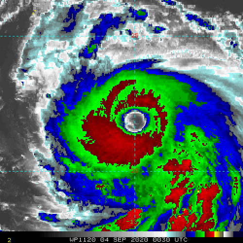
SUPER TYPHOON (STY) 11W (HAISHEN), LOCATED APPROXIMATELY 493
NM SOUTHEAST OF KADENA AB, OKINAWA, HAS TRACKED NORTHWESTWARD AT
08 KNOTS OVER THE PAST SIX HOURS. STY 11W HAS RAPIDLY INTENSIFIED
50 KNOTS OVER THE PAST 24 HOURS FROM 85 KNOTS TO THE CURRENT
INTENSITY OF 135 KNOTS. ANIMATED MULTISPECTRAL SATELLITE IMAGERY
SHOWS A 35NM ROUND EYE, WHICH SUPPORTS THE INITIAL POSITION WITH
GOOD CONFIDENCE. A 032200Z SSMIS 91GHZ MICROWAVE IMAGE DEPICTS A
COMPACT EYEWALL, APPROXIMATELY 100NM DIAMETER, WITH SPIRAL BANDING
OVER THE SOUTHERN SEMICIRCLE. THE INITIAL INTENSITY IS ASSESSED AT
135 KNOTS BASED ON DVORAK CURRENT INTENSITY ESTIMATES RANGING FROM
6.5 (127 KNOTS) TO 7.0 (140 KNOTS). UPPER-LEVEL ANALYSIS REVEALS A
FAVORABLE ENVIRONMENT WITH LOW VERTICAL WIND SHEAR (VWS) AND RADIAL
OUTFLOW. ADDITIONALLY, SST VALUES (30-31C) AND HIGH OCEAN HEAT
CONTENT VALUES ARE CONDUCIVE FOR FURTHER DEVELOPMENT. THE 03/1200Z
500MB ANALYSIS SHOWS A DEEP MIDLATITUDE SHORTWAVE TROUGH OVER THE
EAST CHINA SEA AND WESTERN JAPAN WITH A BROAD SUBTROPICAL RIDGE
ENTRENCHED NORTH OF THE SYSTEM AND A WEAK EXTENSION OF THIS STR
EXTENDING SOUTHWESTWARD TO ABOUT 25N 130E. STY 11W IS TRACKING WEST-
NORTHWESTWARD UNDER THE STEERING INFLUENCE OF THE DEEP-LAYERED
SUBTROPICAL RIDGE (STR) AND IS TRACKING TOWARD A COL REGION
POSITIONED JUST SOUTH OF OKINAWA.
3. FORECAST REASONING.
A. THERE IS NO SIGNIFICANT CHANGE TO THE FORECAST PHILOSOPHY FROM
THE LAST PROGNOSTIC REASONING MESSAGE.
B. THE STR IS FORECAST TO BUILD AND REMAIN STATIONARY OVER JAPAN
WITH THE SHORTWAVE TROUGH GRADUALLY FILLING OVER THE KOREAN
PENINSULA. THE NUMERICAL MODEL TRACKERS ARE NOW IN CLOSER AGREEMENT
NEAR OKINAWA WITH A SPREAD OF 70NM. THE FORECAST TRACK REMAINS
HIGHLY CONSISTENT WITH THE PREVIOUS FORECAST AND INDICATES A NORTH-
NORTHWESTWARD TRACK OVER AMAMI OSHIMA THEN JUST WEST OF KYUSHU AT
TAU 72. NUMERICAL MODEL GUIDANCE HAS REMAINED STABLE AND THE 03/12Z
ECMWF ENSEMBLE ALSO SUPPORTS THE FORECAST TRACK, HOWEVER, THE SYSTEM
COULD TRACK CLOSER TO SASEBO / KYUSHU DUE TO UNCERTAINTY IN THE
MODELS, WHICH ARE IN OVERALL FAIR AGREEMENT WITH A 100NM SPREAD IN
SOLUTIONS NEAR TAU 72. STY 11W IS FORECAST TO MAINTAIN STY INTENSITY
THROUGH TAU 36 WITH GRADUAL WEAKENING AFTER TAU 36 AS THE SYSTEM
TRACKS POLEWARD.
C. IN THE EXTENDED PERIOD, NUMERICAL MODEL GUIDANCE DIVERGES WITH
INCREASING UNCERTAINTY IN THE EXACT TRACK OVER SOUTH KOREA. STY 11W
IS FORECAST TO BEGIN EXTRA-TROPICAL TRANSITION (ETT) NEAR TAU 72 AS
IT INTERACTS WITH THE SHORTWAVE TROUGH AND WILL ACCELERATE POLEWARD
AND COMPLETE ETT BY TAU 96 WHEN IT GAINS FRONTAL CHARACTERISTICS
OVER NORTH KOREA. SIGNIFICANT WEAKENING WILL OCCUR OVER THE KOREAN
PENINSULA DUE TO INCREASING VWS AND INTERACTION WITH MOUNTAINOUS
TERRAIN. OVERALL, THERE IS MODERATE CONFIDENCE IN THE JTWC FORECAST
TRACK, WHICH IS POSITIONED CLOSE TO THE MULTI-MODEL CONSENSUS.//
NNNN
WPAC: HAISHEN - Post-Tropical
Moderator: S2k Moderators

Re: WPAC: HAISHEN - Typhoon
euro6208 wrote:Further development likely and track may be shifted east to Kyushu.
WDPN32 PGTW 040300
MSGID/GENADMIN/JOINT TYPHOON WRNCEN PEARL HARBOR HI//
SUBJ/PROGNOSTIC REASONING FOR SUPER TYPHOON 11W (HAISHEN) WARNING NR
015//
RMKS/
1. FOR METEOROLOGISTS.
2. 6 HOUR SUMMARY AND ANALYSIS.
SUPER TYPHOON (STY) 11W (HAISHEN), LOCATED APPROXIMATELY 493
NM SOUTHEAST OF KADENA AB, OKINAWA, HAS TRACKED NORTHWESTWARD AT
08 KNOTS OVER THE PAST SIX HOURS. STY 11W HAS RAPIDLY INTENSIFIED
50 KNOTS OVER THE PAST 24 HOURS FROM 85 KNOTS TO THE CURRENT
INTENSITY OF 135 KNOTS. ANIMATED MULTISPECTRAL SATELLITE IMAGERY
SHOWS A 35NM ROUND EYE, WHICH SUPPORTS THE INITIAL POSITION WITH
GOOD CONFIDENCE. A 032200Z SSMIS 91GHZ MICROWAVE IMAGE DEPICTS A
COMPACT EYEWALL, APPROXIMATELY 100NM DIAMETER, WITH SPIRAL BANDING
OVER THE SOUTHERN SEMICIRCLE. THE INITIAL INTENSITY IS ASSESSED AT
135 KNOTS BASED ON DVORAK CURRENT INTENSITY ESTIMATES RANGING FROM
6.5 (127 KNOTS) TO 7.0 (140 KNOTS). UPPER-LEVEL ANALYSIS REVEALS A
FAVORABLE ENVIRONMENT WITH LOW VERTICAL WIND SHEAR (VWS) AND RADIAL
OUTFLOW. ADDITIONALLY, SST VALUES (30-31C) AND HIGH OCEAN HEAT
CONTENT VALUES ARE CONDUCIVE FOR FURTHER DEVELOPMENT. THE 03/1200Z
500MB ANALYSIS SHOWS A DEEP MIDLATITUDE SHORTWAVE TROUGH OVER THE
EAST CHINA SEA AND WESTERN JAPAN WITH A BROAD SUBTROPICAL RIDGE
ENTRENCHED NORTH OF THE SYSTEM AND A WEAK EXTENSION OF THIS STR
EXTENDING SOUTHWESTWARD TO ABOUT 25N 130E. STY 11W IS TRACKING WEST-
NORTHWESTWARD UNDER THE STEERING INFLUENCE OF THE DEEP-LAYERED
SUBTROPICAL RIDGE (STR) AND IS TRACKING TOWARD A COL REGION
POSITIONED JUST SOUTH OF OKINAWA.
3. FORECAST REASONING.
A. THERE IS NO SIGNIFICANT CHANGE TO THE FORECAST PHILOSOPHY FROM
THE LAST PROGNOSTIC REASONING MESSAGE.
B. THE STR IS FORECAST TO BUILD AND REMAIN STATIONARY OVER JAPAN
WITH THE SHORTWAVE TROUGH GRADUALLY FILLING OVER THE KOREAN
PENINSULA. THE NUMERICAL MODEL TRACKERS ARE NOW IN CLOSER AGREEMENT
NEAR OKINAWA WITH A SPREAD OF 70NM. THE FORECAST TRACK REMAINS
HIGHLY CONSISTENT WITH THE PREVIOUS FORECAST AND INDICATES A NORTH-
NORTHWESTWARD TRACK OVER AMAMI OSHIMA THEN JUST WEST OF KYUSHU AT
TAU 72. NUMERICAL MODEL GUIDANCE HAS REMAINED STABLE AND THE 03/12Z
ECMWF ENSEMBLE ALSO SUPPORTS THE FORECAST TRACK, HOWEVER, THE SYSTEM
COULD TRACK CLOSER TO SASEBO / KYUSHU DUE TO UNCERTAINTY IN THE
MODELS, WHICH ARE IN OVERALL FAIR AGREEMENT WITH A 100NM SPREAD IN
SOLUTIONS NEAR TAU 72. STY 11W IS FORECAST TO MAINTAIN STY INTENSITY
THROUGH TAU 36 WITH GRADUAL WEAKENING AFTER TAU 36 AS THE SYSTEM
TRACKS POLEWARD.
C. IN THE EXTENDED PERIOD, NUMERICAL MODEL GUIDANCE DIVERGES WITH
INCREASING UNCERTAINTY IN THE EXACT TRACK OVER SOUTH KOREA. STY 11W
IS FORECAST TO BEGIN EXTRA-TROPICAL TRANSITION (ETT) NEAR TAU 72 AS
IT INTERACTS WITH THE SHORTWAVE TROUGH AND WILL ACCELERATE POLEWARD
AND COMPLETE ETT BY TAU 96 WHEN IT GAINS FRONTAL CHARACTERISTICS
OVER NORTH KOREA. SIGNIFICANT WEAKENING WILL OCCUR OVER THE KOREAN
PENINSULA DUE TO INCREASING VWS AND INTERACTION WITH MOUNTAINOUS
TERRAIN. OVERALL, THERE IS MODERATE CONFIDENCE IN THE JTWC FORECAST
TRACK, WHICH IS POSITIONED CLOSE TO THE MULTI-MODEL CONSENSUS.//
NNNN
Until conditions start becoming less favorable later tomorrow, the only thing that could impede Haishen’s further intensification is another EWRC. I think it’s safe from one for the next 6-12 hours at least.
1 likes
Irene '11 Sandy '12 Hermine '16 5/15/2018 Derecho Fay '20 Isaias '20 Elsa '21 Henri '21 Ida '21
I am only a meteorology enthusiast who knows a decent amount about tropical cyclones. Look to the professional mets, the NHC, or your local weather office for the best information.
I am only a meteorology enthusiast who knows a decent amount about tropical cyclones. Look to the professional mets, the NHC, or your local weather office for the best information.

Re: WPAC: HAISHEN - Typhoon
2020SEP03 203000 6.7 925.9 132.2 6.7 6.7 6.7 NO LIMIT OFF OFF OFF OFF 18.07 -73.48 EYE 31 IR 80.4 21.59 -135.57 ARCHER HIM-8 25.9
2020SEP03 210000 6.7 925.9 132.2 6.7 6.3 6.3 NO LIMIT OFF OFF OFF OFF 18.20 -74.66 EYE/L 35 IR 80.4 21.55 -135.59 ARCHER HIM-8 25.9
2020SEP03 211000 6.7 925.9 132.2 6.6 6.2 6.2 NO LIMIT ON OFF OFF OFF 18.23 -73.09 EYE/L 34 IR 80.4 21.56 -135.49 ARCHER HIM-8 25.9
2020SEP03 215000 6.7 925.9 132.2 6.5 6.2 6.2 NO LIMIT ON OFF OFF OFF 19.69 -73.40 EYE/L 34 IR 80.4 21.60 -135.50 ARCHER HIM-8 25.9
2020SEP03 223000 6.7 925.8 132.2 6.5 6.6 6.6 NO LIMIT ON OFF OFF OFF 18.81 -71.92 EYE 33 IR 80.4 21.66 -135.47 ARCHER HIM-8 26.0
2020SEP03 224000 6.7 925.8 132.2 6.4 6.1 6.1 NO LIMIT ON FLG OFF OFF 18.71 -72.05 EYE/L 35 IR 80.4 21.69 -135.31 ARCHER HIM-8 26.1
2020SEP03 233000 6.7 925.8 132.2 6.2 5.8 5.8 NO LIMIT ON FLG OFF OFF 19.29 -68.80 EYE/L 37 IR 80.4 21.76 -135.20 ARCHER HIM-8 26.2
2020SEP04 000000 6.7 925.8 132.2 6.1 5.8 5.8 NO LIMIT ON FLG OFF OFF 19.87 -69.27 EYE/L 39 IR 80.4 21.77 -135.12 ARCHER HIM-8 26.2
2020SEP04 003000 6.7 925.8 132.2 6.0 5.9 5.9 NO LIMIT ON FLG OFF OFF 19.34 -70.42 EYE/L 40 IR 80.4 21.82 -135.01 ARCHER HIM-8 26.3
2020SEP04 005000 6.7 922.1 132.2 6.0 5.9 5.9 NO LIMIT ON FLG OFF OFF 19.95 -70.43 EYE/L 38 IR 80.4 21.86 -134.91 ARCHER HIM-8 26.4
2020SEP04 012000 6.7 922.1 132.2 6.0 5.9 5.9 NO LIMIT ON FLG OFF OFF 19.95 -70.24 EYE/L 38 IR 80.4 21.92 -134.85 ARCHER HIM-8 26.5
2020SEP04 020000 6.7 922.1 132.2 5.8 6.0 6.0 NO LIMIT ON FLG OFF OFF 20.47 -70.42 EYE/L 36 IR 80.4 21.93 -134.69 ARCHER HIM-8 26.5
0 likes
ヤンデレ女が寝取られるているのを見たい!!!
ECMWF ensemble NWPAC plots: https://ecmwfensnwpac.imgbb.com/
Multimodel NWPAC plots: https://multimodelnwpac.imgbb.com/
GFS Ensemble NWPAC plots (16 & 35 day forecast): https://gefsnwpac.imgbb.com/
Plots updated automatically
ECMWF ensemble NWPAC plots: https://ecmwfensnwpac.imgbb.com/
Multimodel NWPAC plots: https://multimodelnwpac.imgbb.com/
GFS Ensemble NWPAC plots (16 & 35 day forecast): https://gefsnwpac.imgbb.com/
Plots updated automatically
Re: WPAC: HAISHEN - Typhoon
Cloud tops look to be cooling again. Haishen’s eye temps could rival Laura, whose eye got to +21.35C.
The eye is also starting to contract and reach Dorian levels of clear. All of this indicates Haishen is still strengthening, and Dmin has only been a temporary hurdle. If this keeps up, Dmax could be crazy.
The eye is also starting to contract and reach Dorian levels of clear. All of this indicates Haishen is still strengthening, and Dmin has only been a temporary hurdle. If this keeps up, Dmax could be crazy.
1 likes
Irene '11 Sandy '12 Hermine '16 5/15/2018 Derecho Fay '20 Isaias '20 Elsa '21 Henri '21 Ida '21
I am only a meteorology enthusiast who knows a decent amount about tropical cyclones. Look to the professional mets, the NHC, or your local weather office for the best information.
I am only a meteorology enthusiast who knows a decent amount about tropical cyclones. Look to the professional mets, the NHC, or your local weather office for the best information.
-
dexterlabio
- Category 5

- Posts: 3503
- Joined: Sat Oct 24, 2009 11:50 pm
Re: WPAC: HAISHEN - Typhoon
aspen wrote:mrbagyo wrote:Poleward outflow is almost non-existent. Haishen needs that to truly max out
https://i.imgur.com/u6TpYVd.gif
Does Haishen really need it? It seems to be ventilating very well; the eye is about to hit 20C according to the UW-CIMSS ADT page.
This talk takes me back to 2016 with Haima...I remember reading some theory that its lack of poleward outflow may have led to a series of "destructive" EWRC. Perhaps an intense cyclone with healthy dual outflow has less chance of undergoing EWRCs, or if there will be one, it will be more of the so-called "eyewall melding."
1 likes
Personal Forecast Disclaimer:
The posts in this forum are NOT official forecast and should not be used as such. They are just the opinion of the poster and may or may not be backed by sound meteorological data. They are NOT endorsed by any professional institution or storm2k.org. For official information, please refer to the NHC and NWS products.
The posts in this forum are NOT official forecast and should not be used as such. They are just the opinion of the poster and may or may not be backed by sound meteorological data. They are NOT endorsed by any professional institution or storm2k.org. For official information, please refer to the NHC and NWS products.
-
dexterlabio
- Category 5
- Posts: 3503
- Joined: Sat Oct 24, 2009 11:50 pm
Re: WPAC: HAISHEN - Typhoon
I don't know but in my opinion, at this point, Haishen looks good enough to be called a Cat5.
0 likes
Personal Forecast Disclaimer:
The posts in this forum are NOT official forecast and should not be used as such. They are just the opinion of the poster and may or may not be backed by sound meteorological data. They are NOT endorsed by any professional institution or storm2k.org. For official information, please refer to the NHC and NWS products.
The posts in this forum are NOT official forecast and should not be used as such. They are just the opinion of the poster and may or may not be backed by sound meteorological data. They are NOT endorsed by any professional institution or storm2k.org. For official information, please refer to the NHC and NWS products.
Re: WPAC: HAISHEN - Typhoon
Personal observations: AMSU estimates using NOAA-19 seem to have a low bias at higher intensity recently. The same is observed in Maysak. I would be a bit more cautious to use those estimates.
Personal intensity assessment at 00Z is 135kt.
Personal intensity assessment at 00Z is 135kt.
0 likes
Personal Forecast Disclaimer:
The posts in this forum are NOT official forecast and should not be used as such. They are just the opinion of the poster and may or may not be backed by sound meteorological data. They are NOT endorsed by any professional institution or storm2k.org. For official information, please refer to RSMC and NWS products.
The posts in this forum are NOT official forecast and should not be used as such. They are just the opinion of the poster and may or may not be backed by sound meteorological data. They are NOT endorsed by any professional institution or storm2k.org. For official information, please refer to RSMC and NWS products.
-
eastcoastFL

- Category 5
- Posts: 3996
- Age: 44
- Joined: Thu Apr 12, 2007 12:29 pm
- Location: Palm City, FL
Re: WPAC: HAISHEN - Typhoon
They’re expecting 100 knots as it reaches Korea. I wonder how they prep for Typhoons in N. Korea. Thankfully it’ll be a little weaker when it gets there but it probably still does serious damage to those homes.

0 likes
Personal Forecast Disclaimer:
The posts in this forum are NOT official forecast and should not be used as such. They are just the opinion of the poster and may or may not be backed by sound meteorological data. They are NOT endorsed by any professional institution or storm2k.org. For official information, please refer to the NHC and NWS products.
The posts in this forum are NOT official forecast and should not be used as such. They are just the opinion of the poster and may or may not be backed by sound meteorological data. They are NOT endorsed by any professional institution or storm2k.org. For official information, please refer to the NHC and NWS products.
-
eastcoastFL
- Category 5
- Posts: 3996
- Age: 44
- Joined: Thu Apr 12, 2007 12:29 pm
- Location: Palm City, FL
Re: WPAC: HAISHEN - Typhoon
0 likes
Personal Forecast Disclaimer:
The posts in this forum are NOT official forecast and should not be used as such. They are just the opinion of the poster and may or may not be backed by sound meteorological data. They are NOT endorsed by any professional institution or storm2k.org. For official information, please refer to the NHC and NWS products.
The posts in this forum are NOT official forecast and should not be used as such. They are just the opinion of the poster and may or may not be backed by sound meteorological data. They are NOT endorsed by any professional institution or storm2k.org. For official information, please refer to the NHC and NWS products.
-
mrbagyo

- Category 5
- Posts: 3963
- Age: 33
- Joined: Thu Apr 12, 2012 9:18 am
- Location: 14.13N 120.98E
- Contact:
Re: WPAC: HAISHEN - Typhoon
Beauty

2 likes
The posts in this forum are NOT official forecast and should not be used as such. They are just the opinion of the poster and may or may not be backed by sound meteorological data. They are NOT endorsed by any professional institution or storm2k.org. For official information, please refer to RSMC, NHC and NWS products.
-
euro6208
Re: WPAC: HAISHEN - Typhoon
aspen wrote:Cloud tops look to be cooling again. Haishen’s eye temps could rival Laura, whose eye got to +21.35C.
The eye is also starting to contract and reach Dorian levels of clear. All of this indicates Haishen is still strengthening, and Dmin has only been a temporary hurdle. If this keeps up, Dmax could be crazy.
It still amazes me how Dorian got up to 160 knots despite Dvorak only peaking at 6.5 (127 knots) and ADT was 124.6 knots or 6.4.
If Dorian was in the WPAC maybe 125-130 knots peak.
Talk about a huge difference.
Haishen is displaying even more colder convection and more expansive than Dorian in it's life.
Recon recon recon.
0 likes

Re: WPAC: HAISHEN - Typhoon
Eye appears to have contracted a few miles over the last few hours, which may be what's causing the cooling CDO. DMAX later tonight should take Haishen easily to T7.0, especially with a smaller eye.


0 likes
Very useful information on the Dvorak Technique --
https://severe.worldweather.wmo.int/TCF ... kBeven.pdf
https://severe.worldweather.wmo.int/TCF ... kBeven.pdf
Re: WPAC: HAISHEN - Typhoon
2020SEP04 033000 6.5 927.1 127.0 6.0 6.6 6.6 NO LIMIT ON OFF OFF OFF 21.12 -71.07 EYE 34 IR 80.4 22.04 -134.58 ARCHER HIM-8 26.7
0 likes
Very useful information on the Dvorak Technique --
https://severe.worldweather.wmo.int/TCF ... kBeven.pdf
https://severe.worldweather.wmo.int/TCF ... kBeven.pdf
-
euro6208
Re: WPAC: HAISHEN - Typhoon
Easily a 5 there. Eye clearing even more and convection is thickening.
Playing catchup.
Once it reaches its first peak by JTWC, it should be weakening or going through some eyewall replacement.
1 likes

Re: WPAC: HAISHEN - Typhoon
Late-arriving AMSU pass at 0045Z is at 919mb/136kt, so JTWC’s estimate looks reasonable. Given the continued improvement in satellite presentation, an upgrade to category 5 is definitely justifiable at 06Z, despite Dvorak capped at T6.5 due to W ring not thick enough.
0 likes
Personal Forecast Disclaimer:
The posts in this forum are NOT official forecast and should not be used as such. They are just the opinion of the poster and may or may not be backed by sound meteorological data. They are NOT endorsed by any professional institution or storm2k.org. For official information, please refer to RSMC and NWS products.
The posts in this forum are NOT official forecast and should not be used as such. They are just the opinion of the poster and may or may not be backed by sound meteorological data. They are NOT endorsed by any professional institution or storm2k.org. For official information, please refer to RSMC and NWS products.
-
mrbagyo
- Category 5
- Posts: 3963
- Age: 33
- Joined: Thu Apr 12, 2012 9:18 am
- Location: 14.13N 120.98E
- Contact:
Re: WPAC: HAISHEN - Typhoon
I cant wait to see Haishen during DMAX and tomorrow's early morning visible image
0 likes
The posts in this forum are NOT official forecast and should not be used as such. They are just the opinion of the poster and may or may not be backed by sound meteorological data. They are NOT endorsed by any professional institution or storm2k.org. For official information, please refer to RSMC, NHC and NWS products.
-
mrbagyo
- Category 5
- Posts: 3963
- Age: 33
- Joined: Thu Apr 12, 2012 9:18 am
- Location: 14.13N 120.98E
- Contact:
Re: WPAC: HAISHEN - Typhoon
0 likes
The posts in this forum are NOT official forecast and should not be used as such. They are just the opinion of the poster and may or may not be backed by sound meteorological data. They are NOT endorsed by any professional institution or storm2k.org. For official information, please refer to RSMC, NHC and NWS products.
Re: WPAC: HAISHEN - Typhoon
11W HAISHEN 200904 0600 22.2N 134.3E WPAC 140 911
2 likes
ヤンデレ女が寝取られるているのを見たい!!!
ECMWF ensemble NWPAC plots: https://ecmwfensnwpac.imgbb.com/
Multimodel NWPAC plots: https://multimodelnwpac.imgbb.com/
GFS Ensemble NWPAC plots (16 & 35 day forecast): https://gefsnwpac.imgbb.com/
Plots updated automatically
ECMWF ensemble NWPAC plots: https://ecmwfensnwpac.imgbb.com/
Multimodel NWPAC plots: https://multimodelnwpac.imgbb.com/
GFS Ensemble NWPAC plots (16 & 35 day forecast): https://gefsnwpac.imgbb.com/
Plots updated automatically
-
Cunxi Huang

- Category 1

- Posts: 329
- Age: 27
- Joined: Thu Sep 26, 2013 12:17 pm
- Location: San Jose, CA
- Contact:
Re: WPAC: HAISHEN - Typhoon
Hayabusa wrote:11W HAISHEN 200904 0600 22.2N 134.3E WPAC 140 911
noice.
0 likes
06 SuTY SAOMAI | 09 TY LINFA | 10 TY FANAPI | 10 SuTY MEGI | 16 SuTY MERANTI | 19 SuTY LEKIMA | 24 C2 FRANCINE
DO NOT use my posts for life and death decisions. For official information, please refer to products from your RSMC and national weather agency.
DO NOT use my posts for life and death decisions. For official information, please refer to products from your RSMC and national weather agency.
Who is online
Users browsing this forum: No registered users and 48 guests