stormlover2013 wrote:Won’t be a trend till it gets in gom
100% agree.
Moderator: S2k Moderators


stormlover2013 wrote:Won’t be a trend till it gets in gom
gqhebert wrote:HMON 130kt cane heading towards Galveston
Senobia wrote:gqhebert wrote:HMON 130kt cane heading towards Galveston
You have a graphic for this model run?

Senobia wrote:So, what time does the NHC adjust their official tracks (if warranted), based on model data? I thought it was twice daily, but not sure.
Senobia wrote:So, what time does the NHC adjust their official tracks (if warranted), based on model data? I thought it was twice daily, but not sure.


Kingarabian wrote:cheezyWXguy wrote:CyclonicFury wrote:I find it interesting how the Euro weakens Laura in the GoM. Quite the contrast from the GFS and hurricane models.
Is there any shear its forecasting from a source the other models are not picking up on? The rest show near ideal conditions, and with the euro depicting Laura at 995mb upon gulf entry, it doesn't seem like it forecasts much core disruption.
t even deepens it down to 981mb. 15kts of shear it looks like. But there is an anti-cyclone near. So that shear shouldn't bother it that much especially since its a well intact upon emerging into the GOM.

gatorcane wrote:Kingarabian wrote:cheezyWXguy wrote:Is there any shear its forecasting from a source the other models are not picking up on? The rest show near ideal conditions, and with the euro depicting Laura at 995mb upon gulf entry, it doesn't seem like it forecasts much core disruption.
t even deepens it down to 981mb. 15kts of shear it looks like. But there is an anti-cyclone near. So that shear shouldn't bother it that much especially since its a well intact upon emerging into the GOM.
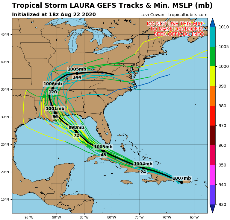
The 12Z Euro also showed 999MB at landfall so that is two runs in a row. The GFS and GEFS ensembles are nowhere near as strong as the hurricane models though the GFS ensembles are a little stronger than the 12Z. My point is not to downplay the situation but if I lived in the northern Gulf I would at least be cautiously optimistic there are good models showing a modest cyclone that are not bombing it out into a major:
https://i.postimg.cc/qqYcHpFc/13-L-gefs-18z.png


gatorcane wrote:Kingarabian wrote:cheezyWXguy wrote:Is there any shear its forecasting from a source the other models are not picking up on? The rest show near ideal conditions, and with the euro depicting Laura at 995mb upon gulf entry, it doesn't seem like it forecasts much core disruption.
t even deepens it down to 981mb. 15kts of shear it looks like. But there is an anti-cyclone near. So that shear shouldn't bother it that much especially since its a well intact upon emerging into the GOM.
The 12Z Euro also showed 999MB at landfall so that is two runs in a row. The GFS and GEFS ensembles are nowhere near as strong as the hurricane models though the GFS ensembles are a little stronger than the 12Z. My point is not to downplay the situation but if I lived in the northern Gulf I would at least be cautiously optimistic there are good models showing a modest cyclone that are not bombing it out into a major:
https://i.postimg.cc/qqYcHpFc/13-L-gefs-18z.png
Kingarabian wrote:Michele B wrote:Kingarabian wrote:18z GFS hours 93-99:
https://i.imgur.com/rQ4EmLv.gif
933??? SERIOUSLY?!?!?!
Isn't that a bit TOO aggressive?!?!?!
It's the GOM and its high OHC so it's unfortunately believable.
CrazyC83 wrote:That said, I remember Hermine of 2016 where the HMON and HWRF were constantly bombing into a major, while the global models didn't show much. It ended up as a cat 1.
AutoPenalti wrote:CrazyC83 wrote:That said, I remember Hermine of 2016 where the HMON and HWRF were constantly bombing into a major, while the global models didn't show much. It ended up as a cat 1.
Was this before their resolution upgrade?

gatorcane wrote:Kingarabian wrote:cheezyWXguy wrote:Is there any shear its forecasting from a source the other models are not picking up on? The rest show near ideal conditions, and with the euro depicting Laura at 995mb upon gulf entry, it doesn't seem like it forecasts much core disruption.
t even deepens it down to 981mb. 15kts of shear it looks like. But there is an anti-cyclone near. So that shear shouldn't bother it that much especially since its a well intact upon emerging into the GOM.
The 12Z Euro also showed 999MB at landfall so that is two runs in a row. The GFS and GEFS ensembles are nowhere near as strong as the hurricane models though the GFS ensembles are a little stronger than the 12Z. My point is not to downplay the situation but if I lived in the northern Gulf I would at least be cautiously optimistic there are good models showing a modest cyclone that are not bombing it out into a major:
https://i.postimg.cc/qqYcHpFc/13-L-gefs-18z.png


Users browsing this forum: No registered users and 12 guests


