
Strength of the system early on and that high pressure dipping down are going to be the biggest factors. The longer it takes to gain strength, the further west it'll probably go. Then we will have to see if the high pressure will come down and affect steering.
Gonna be a good tracker for sure
ATL: ISAIAS - Models
Moderator: S2k Moderators
Re: ATL: INVEST 92L - Models
5 likes

Re: ATL: INVEST 92L - Models
SFLcane wrote:SouthFLTropics wrote:Any thoughts on whether or not the 18z GFS will live up to its happy hour reputation and throw us a crazy solution? If the past is any indicator, 18z will be the “fun run” to watch.
Sent from my iPhone using Tapatalk
Many happy hr GFS runs to go.
Boy, is THAT a fact!
1 likes
Andy D
(For official information, please refer to the NHC and NWS products.)
(For official information, please refer to the NHC and NWS products.)
-
HurricaneFrances04
- Category 2

- Posts: 597
- Joined: Mon Jun 25, 2012 8:09 am
- Location: Fort Lauderdale, Florida

Re: ATL: INVEST 92L - Models
DestinHurricane wrote:I may be 100% wrong but doesn't climo favor stronger ridging and less chance of recurve this early in the season?
 That is climatalogically correct sir.
0 likes
Andy D
(For official information, please refer to the NHC and NWS products.)
(For official information, please refer to the NHC and NWS products.)
-
TheStormExpert
Re: ATL: INVEST 92L - Models
I’m pretty sure I mentioned that the ridge orientation and setup would allow for an increased risk to the Carolinas and NE U.S. Of course this is 10 days out and things will change, but it’s interesting to note that 92L quickly makes a 90° turn to the NE shortly after landfall.
0 likes
-
HurricaneFrances04
- Category 2
- Posts: 597
- Joined: Mon Jun 25, 2012 8:09 am
- Location: Fort Lauderdale, Florida
Re: ATL: INVEST 92L - Models
TheStormExpert wrote:I’m pretty sure I mentioned that the ridge orientation and setup would allow for an increased risk to the Carolinas and NE U.S. Of course this is 10 days out and things will change, but it’s interesting to note that 92L quickly makes a 90° turn to the NE shortly after landfall.
It does about every compass heading on this run. Turns east after landfall, a little southeast, then turns northeast into Atlantic Canada.
If this run panned out it would be a heck of an ACE generator.
0 likes
-
supercane4867
- Category 5

- Posts: 4966
- Joined: Wed Nov 14, 2012 10:43 am

Re: ATL: INVEST 92L - Models
SFLcane wrote:Long ways to go with this one. Irma looked like a shoe in to recurve only to head west. It has to develop first
Exactly. Also, does it seem to anyone else like the models are initializing the center too far north?
1 likes
-
SouthFLTropics

- Category 5
- Posts: 4258
- Age: 50
- Joined: Thu Aug 14, 2003 8:04 am
- Location: Port St. Lucie, Florida
Re: ATL: INVEST 92L - Models
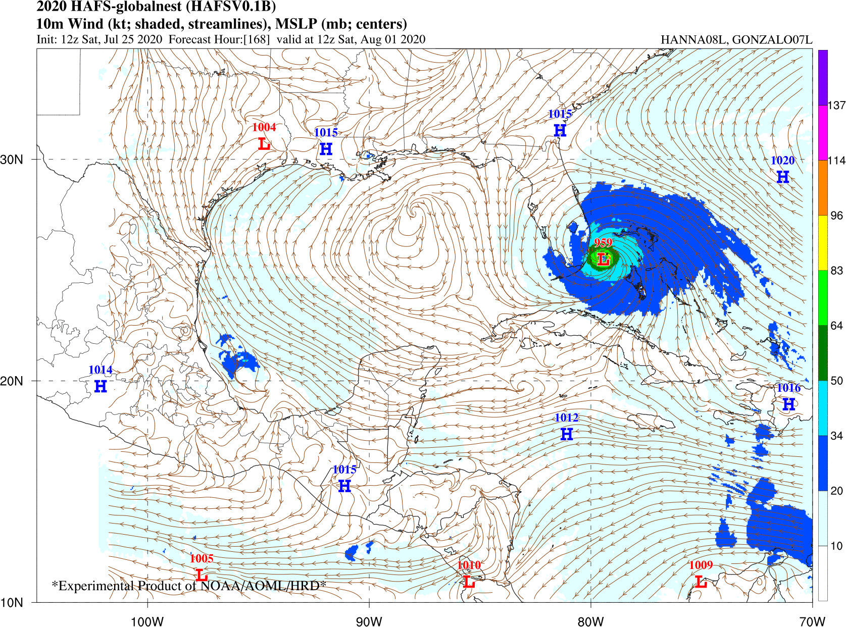
supercane4867 wrote:HAFS experimental model (Future HWRF replacement)
Much faster solution...brings Easy E into South Florida by next Saturday. I called it Easy E because I can’t pronounce Isiais yet...

Sent from my iPhone using Tapatalk
6 likes
Fourth Generation Florida Native
Personal Storm History: David 79, Andrew 92, Erin 95, Floyd 99, Irene 99, Frances 04, Jeanne 04, Wilma 05, Matthew 16, Irma 17, Ian 22, Nicole 22, Milton 24
Personal Storm History: David 79, Andrew 92, Erin 95, Floyd 99, Irene 99, Frances 04, Jeanne 04, Wilma 05, Matthew 16, Irma 17, Ian 22, Nicole 22, Milton 24
-
Hurricane Mike
- Category 2
- Posts: 675
- Joined: Tue Apr 10, 2018 7:44 am
Re: ATL: INVEST 92L - Models
These models do seem in agreement with one thing: This is almost certain to develop.
1 likes
-
AxaltaRacing24
- Category 5
- Posts: 1774
- Age: 25
- Joined: Wed Jul 27, 2016 11:14 am
- Location: Jupiter, FL
Re: ATL: INVEST 92L - Models
Hurricane Mike wrote:These models do seem in agreement with one thing: This is almost certain to develop.
Yeah it's gonna happen. Basically a 120% chance.
2 likes
-
TheStormExpert
Re: ATL: INVEST 92L - Models
I wonder if that cutoff low in the Mississippi Valley had any implications on its final landfall destination? That wasn’t there on the 12z run at least that I noticed.
0 likes
-
SFLcane

- S2K Supporter

- Posts: 10281
- Age: 48
- Joined: Sat Jun 05, 2010 1:44 pm
- Location: Lake Worth Florida
Re: ATL: INVEST 92L - Models
supercane4867 wrote:HAFS experimental model (Future HWRF replacement)
https://uploads.disquscdn.com/images/5dac241a97e5a13f9292403fc9a289baade3b8846f2ce8d321564cb14d4bcd5c.gif
Woah! Link?
0 likes
-
HurricaneFrances04
- Category 2
- Posts: 597
- Joined: Mon Jun 25, 2012 8:09 am
- Location: Fort Lauderdale, Florida
Re: ATL: INVEST 92L - Models
I only see one ensemble member that turns this out to sea. Most show a landfall in Florida or Carolinas/Mid Atlantic. Many show the ridge building in and a turn to the NW/WNW.
0 likes

Re: ATL: INVEST 92L - Models
HurricaneFrances04 wrote:Will be interesting if any ensembles show something similar
https://i.imgur.com/ITDdMEZ.gif
Ummm correct me if I’m wrong, but this doesn’t make any sense. It has it plowing right into a ridge?
0 likes
Re: ATL: INVEST 92L - Models
supercane4867 wrote:HAFS experimental model (Future HWRF replacement)
https://uploads.disquscdn.com/images/5dac241a97e5a13f9292403fc9a289baade3b8846f2ce8d321564cb14d4bcd5c.gif
No matter where this ends up, it is going to be massive in size.
1 likes
Andrew (1992), Irene (1999), Frances (2004), Katrina (2005), Wilma (2005), Fay (2008), Irma (2017), Eta (2020), Ian (2022)
-
cycloneye

- Admin

- Posts: 149283
- Age: 69
- Joined: Thu Oct 10, 2002 10:54 am
- Location: San Juan, Puerto Rico
Re: ATL: INVEST 92L - Models
supercane4867 wrote:HAFS experimental model (Future HWRF replacement)
https://uploads.disquscdn.com/images/5d ... 4bcd5c.gif]
Do you have the area in the NE Caribbean to see how it looks there?
2 likes
Visit the Caribbean-Central America Weather Thread where you can find at first post web cams,radars
and observations from Caribbean basin members Click Here
and observations from Caribbean basin members Click Here

Re: ATL: INVEST 92L - Models
cycloneye wrote:supercane4867 wrote:HAFS experimental model (Future HWRF replacement)
https://uploads.disquscdn.com/images/5d ... 4bcd5c.gif]
Do you have the area in the NE Caribbean to see how it looks there?
1 likes
-
cycloneye
- Admin
- Posts: 149283
- Age: 69
- Joined: Thu Oct 10, 2002 10:54 am
- Location: San Juan, Puerto Rico
Re: ATL: INVEST 92L - Models
KAlexPR wrote:cycloneye wrote:supercane4867 wrote:HAFS experimental model (Future HWRF replacement)
https://uploads.disquscdn.com/images/5d ... 4bcd5c.gif]
Do you have the area in the NE Caribbean to see how it looks there?
https://imgur.com/l0doiyS
Thank you. Well, I am going there.
3 likes
Visit the Caribbean-Central America Weather Thread where you can find at first post web cams,radars
and observations from Caribbean basin members Click Here
and observations from Caribbean basin members Click Here
-
Hypercane_Kyle

- Category 5
- Posts: 3465
- Joined: Sat Mar 07, 2015 7:58 pm
- Location: Cape Canaveral, FL
Re: ATL: INVEST 92L - Models
Anyone care to share what the 12z UKMET showed?
0 likes
My posts are my own personal opinion, defer to the National Hurricane Center (NHC) and other NOAA products for decision making during hurricane season.
Who is online
Users browsing this forum: No registered users and 31 guests