ATL: ETA - Models

Moderator: S2k Moderators

Message
Author
LarryWx
S2K Supporter
S2K Supporter
Posts: 6301
Joined: Sun Sep 07, 2003 2:04 pm
Location: GA

Re: ATL: INVEST 96L - Models

#261 Postby LarryWx » Sat Oct 31, 2020 10:08 am

Shell Mound wrote:
SFLcane wrote:
Shell Mound wrote:Yet none of those members is deeper than ~995 mb prior to interaction with Central America. Based on current trends 96L will likely be much deeper then.

This! We could be looking at strengthening hurricane way before.

The key is that all the models with the best handle on current intensity (GFS/HWRF) trends only show 96L scraping Central America at best, not heading well inland.


Looking closely at the 6Z HWRF animated track, it actually is well inland and is even further inland and south than recent tracks! At hour 105, after being at 949 just before LF, it is well inland in N Nicaragua (13.8N, 85W) at 999 mb vs the prior run being further N on the Hond/Nic border (14.5N, 85W) and the 2 runs before that being even further N in Honduras (14.6N, 85.2W) and (15N, 84.3W).
Last edited by LarryWx on Sat Oct 31, 2020 10:19 am, edited 1 time in total.
0 likes   
Personal Forecast Disclaimer:
The posts in this forum are NOT official forecasts and should not be used as such. They are just the opinion of the poster and may or may not be backed by sound meteorological data. They are NOT endorsed by any professional institution or storm2k.org. For official information, please refer to the NHC and NWS products.

User avatar
NDG
S2K Supporter
S2K Supporter
Posts: 15446
Joined: Sun Jul 09, 2006 10:14 pm
Location: Orlando, FL

Re: ATL: INVEST 96L - Models

#262 Postby NDG » Sat Oct 31, 2020 10:17 am

cp79 wrote:
NDG wrote:The trend of the Euro ensembles is of a trend closer to the GFS solution.

https://i.imgur.com/R2u5BR0.gif


Still a lot of Euros have it going into EPAC which I still think is the most likely scenario. It’s just not 90/10 like yesterday. Maybe 70/30.

I still go with a CA system and dying there or going into EPAC at 70%, a N and then NE curve out to Atlantic at 20%, a Zeta track at 5%, and something other than that at 5%.


I counted them, only half bring it to the EPAC, the other half either leave it inland or out to the GOH.
0 likes   

User avatar
NDG
S2K Supporter
S2K Supporter
Posts: 15446
Joined: Sun Jul 09, 2006 10:14 pm
Location: Orlando, FL

Re: ATL: INVEST 96L - Models

#263 Postby NDG » Sat Oct 31, 2020 10:19 am

LarryWx wrote:
Shell Mound wrote:
SFLcane wrote:This! We could be looking at strengthening hurricane way before.

The key is that all the models with the best handle on current intensity (GFS/HWRF) trends only show 96L scraping Central America at best, not heading well inland.


Looking closely at the 6Z HWRF animated track, it actually is well inland and is even further inland than recent tracks! At hour 105, after being at 949 just before LF, it is well inland in N Nicaragua (13.8N, 85W) at 999 mb vs the prior run being further N on the Hond/Nic border (14.5N, 85W) and the 2 runs before that being even further N in Honduras (14.6N, 85.2W) and (15N, 84.3W).


The HWRF is most times too progressive with its forecast timing.
2 likes   

LarryWx
S2K Supporter
S2K Supporter
Posts: 6301
Joined: Sun Sep 07, 2003 2:04 pm
Location: GA

Re: ATL: INVEST 96L - Models

#264 Postby LarryWx » Sat Oct 31, 2020 10:22 am

NDG wrote:
LarryWx wrote:
Shell Mound wrote:The key is that all the models with the best handle on current intensity (GFS/HWRF) trends only show 96L scraping Central America at best, not heading well inland.


Looking closely at the 6Z HWRF animated track, it actually is well inland and is even further inland than recent tracks! At hour 105, after being at 949 just before LF, it is well inland in N Nicaragua (13.8N, 85W) at 999 mb vs the prior run being further N on the Hond/Nic border (14.5N, 85W) and the 2 runs before that being even further N in Honduras (14.6N, 85.2W) and (15N, 84.3W).


The HWRF is most times too progressive with its forecast timing.


The point of my post is that Shell Mound said the GFS/HWRF trends were toward only scraping CA at best whereas in reality that’s not the case for the HWRF trend, which is the opposite!
Last edited by LarryWx on Sat Oct 31, 2020 10:25 am, edited 1 time in total.
0 likes   
Personal Forecast Disclaimer:
The posts in this forum are NOT official forecasts and should not be used as such. They are just the opinion of the poster and may or may not be backed by sound meteorological data. They are NOT endorsed by any professional institution or storm2k.org. For official information, please refer to the NHC and NWS products.

TheStormExpert

Re: ATL: INVEST 96L - Models

#265 Postby TheStormExpert » Sat Oct 31, 2020 10:25 am

Shell Mound wrote:
NDG wrote:
Jr0d wrote:The EURO is notorious for overdoing ridges, the GFS over estimates troughs....

Middle-ground might be the most reasonable solution here.

The recon data, especially from the high-altitude missions is invaluable right now. Unfortunately we have a few more days of watching the models with incomplete inputs.


I agree, a consensus between the two is what will most like be the outcome as usual.

I say that 96L will make landfall in Nicaragua/Honduras border area but then go north back to the Caribbean.
So in another words not go go as far inland as the Euro has it and for it not to stay offshore as the latest GFS has it.

That’s my “forecast” as well. The key is that a brief landfall, say, near Cabo Gracias a Dios would result in very little weakening, as mountains lie well inland.

If this is the case then the northern Gulf Coast could likely see YET another storm threat in the first half of November. :roll:
0 likes   

LarryWx
S2K Supporter
S2K Supporter
Posts: 6301
Joined: Sun Sep 07, 2003 2:04 pm
Location: GA

Re: ATL: INVEST 96L - Models

#266 Postby LarryWx » Sat Oct 31, 2020 10:33 am

Not a good model overall imo though some others here like it, but the 12Z ICON is deep into Nicaragua and, if anything, is trending more that way. It takes the remnants into the E PAC.

So far and subject to change, I’m seeing the GFS/para-GFS largely on their own in not going well into Nic/Hond.

By the way, deeper into CA does not mean there def won’t be a 2nd low threatening FL later. The 12Z ICON has a 2nd low form later in the W Car. This is from a piece of energy now still just E of Lesser A, NOT 96L!
Last edited by LarryWx on Sat Oct 31, 2020 10:54 am, edited 2 times in total.
0 likes   
Personal Forecast Disclaimer:
The posts in this forum are NOT official forecasts and should not be used as such. They are just the opinion of the poster and may or may not be backed by sound meteorological data. They are NOT endorsed by any professional institution or storm2k.org. For official information, please refer to the NHC and NWS products.

User avatar
NDG
S2K Supporter
S2K Supporter
Posts: 15446
Joined: Sun Jul 09, 2006 10:14 pm
Location: Orlando, FL

Re: ATL: INVEST 96L - Models

#267 Postby NDG » Sat Oct 31, 2020 10:46 am

GeneratorPower wrote:
NDG wrote:The trend of the Euro ensembles is of a trend closer to the GFS solution.

https://i.imgur.com/R2u5BR0.gif

This isn’t showing properly. You’re using two different valid times in the GIF.


Even when I put them all for the same forecasted time, you can still see the trend of more ensembles staying in the area of the NE Tip of Honduras/Nicaragua. Don't look at the time stamp, look at the forecasted hour below the time stamp.

Image
0 likes   

cp79

Re: ATL: INVEST 96L - Models

#268 Postby cp79 » Sat Oct 31, 2020 10:48 am

NDG wrote:
cp79 wrote:
NDG wrote:The trend of the Euro ensembles is of a trend closer to the GFS solution.

https://i.imgur.com/R2u5BR0.gif


Still a lot of Euros have it going into EPAC which I still think is the most likely scenario. It’s just not 90/10 like yesterday. Maybe 70/30.

I still go with a CA system and dying there or going into EPAC at 70%, a N and then NE curve out to Atlantic at 20%, a Zeta track at 5%, and something other than that at 5%.


I counted them, only half bring it to the EPAC, the other half either leave it inland or out to the GOH.


I personally don’t think it’ll get into EPAC. I think the mountains will destroy it. They’re very high there. The question is whether the mountains could break up the system and create another low to the north like some models say could happen. It’s so rare we see that so I don’t know what to make of that solution. It would be kinda cool to see as long as the other piece stays weak and doesn’t affect anyone.
0 likes   

User avatar
Spacecoast
Category 2
Category 2
Posts: 758
Joined: Thu Aug 31, 2017 2:03 pm

Re: ATL: INVEST 96L - Models

#269 Postby Spacecoast » Sat Oct 31, 2020 10:56 am

Image
Image
Image
3 likes   

User avatar
SFLcane
S2K Supporter
S2K Supporter
Posts: 10163
Age: 47
Joined: Sat Jun 05, 2010 1:44 pm
Location: Lake Worth Florida

Re: ATL: INVEST 96L - Models

#270 Postby SFLcane » Sat Oct 31, 2020 11:10 am

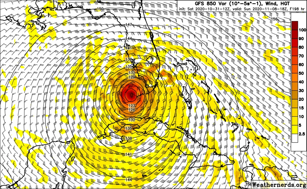
Make that 4 runs gfs heads north again. :eek:
3 likes   

AutoPenalti
Category 5
Category 5
Posts: 4030
Age: 29
Joined: Mon Aug 17, 2015 4:16 pm
Location: Ft. Lauderdale, Florida

Re: ATL: INVEST 96L - Models

#271 Postby AutoPenalti » Sat Oct 31, 2020 11:13 am

GFS looks like it caved to its ensemble members after 4 runs of the same north turn.
0 likes   
The posts in this forum are NOT official forecasts and should not be used as such. They are just the opinion of the poster and may or may not be backed by sound meteorological data. They are NOT endorsed by any professional institution or STORM2K. For official information, please refer to products from the NHC and NWS.


Model Runs Cheat Sheet:
GFS (5:30 AM/PM, 11:30 AM/PM)
HWRF, GFDL, UKMET, NAVGEM (6:30-8:00 AM/PM, 12:30-2:00 AM/PM)
ECMWF (1:45 AM/PM)

TCVN
is a weighted averaged

User avatar
SFLcane
S2K Supporter
S2K Supporter
Posts: 10163
Age: 47
Joined: Sat Jun 05, 2010 1:44 pm
Location: Lake Worth Florida

Re: ATL: INVEST 96L - Models

#272 Postby SFLcane » Sat Oct 31, 2020 11:16 am

AutoPenalti wrote:GFS looks like it caved to its ensemble members after 4 runs of the same north turn.


Likely a major hurricane heading right for Florida @174
0 likes   

LarryWx
S2K Supporter
S2K Supporter
Posts: 6301
Joined: Sun Sep 07, 2003 2:04 pm
Location: GA

Re: ATL: INVEST 96L - Models

#273 Postby LarryWx » Sat Oct 31, 2020 11:21 am

The 12Z CMC is also in. Regardless of what may or may not happen later to FL from 96L or a 2nd low, the consensus of the more reliable portion of the models in so far (I.e., early in the runs) (12Z ICON, GFS, UK, and CMC) is that parts of Nic/Hond/Guat are under an increasing threat of devastating widespread flooding.
Last edited by LarryWx on Sat Oct 31, 2020 11:38 am, edited 2 times in total.
0 likes   
Personal Forecast Disclaimer:
The posts in this forum are NOT official forecasts and should not be used as such. They are just the opinion of the poster and may or may not be backed by sound meteorological data. They are NOT endorsed by any professional institution or storm2k.org. For official information, please refer to the NHC and NWS products.

User avatar
SFLcane
S2K Supporter
S2K Supporter
Posts: 10163
Age: 47
Joined: Sat Jun 05, 2010 1:44 pm
Location: Lake Worth Florida

Re: ATL: INVEST 96L - Models

#274 Postby SFLcane » Sat Oct 31, 2020 11:25 am

Image
0 likes   

cp79

Re: ATL: INVEST 96L - Models

#275 Postby cp79 » Sat Oct 31, 2020 11:27 am

As a Tampa resident, I’m happy the GFS is showing this solution now bc their track record 7-days out is like one-in-million. But that would be a scary track for Tampa Bay if that materialized.
0 likes   

User avatar
SFLcane
S2K Supporter
S2K Supporter
Posts: 10163
Age: 47
Joined: Sat Jun 05, 2010 1:44 pm
Location: Lake Worth Florida

Re: ATL: INVEST 96L - Models

#276 Postby SFLcane » Sat Oct 31, 2020 11:28 am

3 likes   

shah83
Category 1
Category 1
Posts: 302
Joined: Sun Jul 31, 2016 4:55 pm

Re: ATL: INVEST 96L - Models

#277 Postby shah83 » Sat Oct 31, 2020 11:35 am

These GFS runs also have pretty serious surge implications for the west coast of Florida.
2 likes   

Shell Mound
Category 5
Category 5
Posts: 2434
Age: 32
Joined: Thu Sep 07, 2017 3:39 pm
Location: St. Petersburg, FL → Scandinavia

Re: ATL: INVEST 96L - Models

#278 Postby Shell Mound » Sat Oct 31, 2020 11:37 am

I don’t think I’ve ever seen such sustained run-to-run consistency by the operational GFS in terms of track and intensity over five cycles. This isn’t a fluke...
0 likes   
CVW / MiamiensisWx / Shell Mound
The posts in this forum are NOT official forecasts and should not be used as such. They are just the opinion of the poster and may or may not be backed by sound meteorological data. They are NOT endorsed by any professional institution or STORM2K. For official information, please refer to products from the NHC and NWS.

TheStormExpert

Re: ATL: INVEST 96L - Models

#279 Postby TheStormExpert » Sat Oct 31, 2020 11:40 am

The 12z GFS is west and slower on approach to Florida when compared to the 06z run. Must be correcting it’s right-bias. Folks anywhere from Texas, Louisiana to Florida better be watching this!
0 likes   

TheStormExpert

Re: ATL: INVEST 96L - Models

#280 Postby TheStormExpert » Sat Oct 31, 2020 11:41 am

Shell Mound wrote:I don’t think I’ve ever seen such sustained run-to-run consistency by the operational GFS in terms of track and intensity over five cycles. This isn’t a fluke...

Pre-Zeta going NE through Cuba and The Bahamas?
0 likes   


Return to “2020”

Who is online

Users browsing this forum: No registered users and 2 guests