

Hypercane_Kyle wrote:Anyone care to share what the 12z UKMET showed?

looks like a bad time
Moderator: S2k Moderators
Hypercane_Kyle wrote:Anyone care to share what the 12z UKMET showed?
DestinHurricane wrote:
I may be 100% wrong but doesn't climo favor stronger ridging and less chance of recurve this early in the season?
Frank2 wrote:DestinHurricane wrote:
I may be 100% wrong but doesn't climo favor stronger ridging and less chance of recurve this early in the season?
If it were late June but not now. August is next Sunday and the subtropical high begins to drift east in early August - it's probably one factor for the current recurve solution...
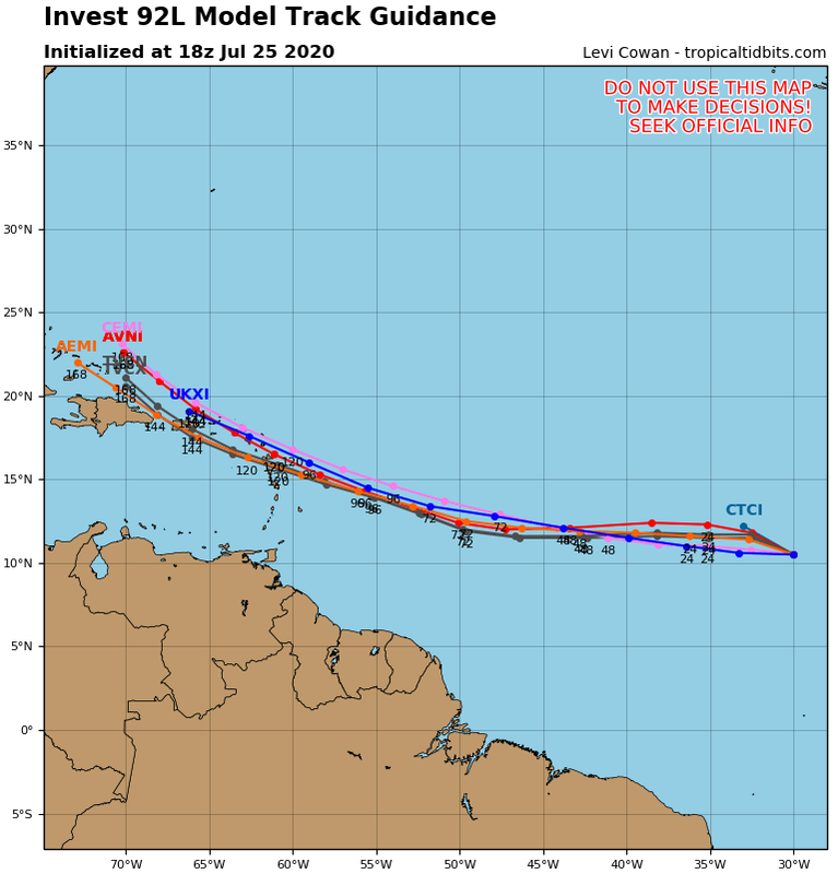
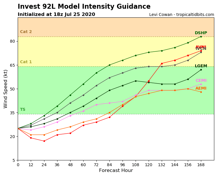
gatorcane wrote:Remarkably tight consensus:
https://i.postimg.cc/4yvMr1yw/92-L-tracks-18z.png
https://i.postimg.cc/YCCVsYHf/92-L-intensity-18z.png


plasticup wrote:gatorcane wrote:Remarkably tight consensus:
https://i.postimg.cc/4yvMr1yw/92-L-tracks-18z.png
https://i.postimg.cc/YCCVsYHf/92-L-intensity-18z.png
Breathing a sigh of relief here in Bermuda.
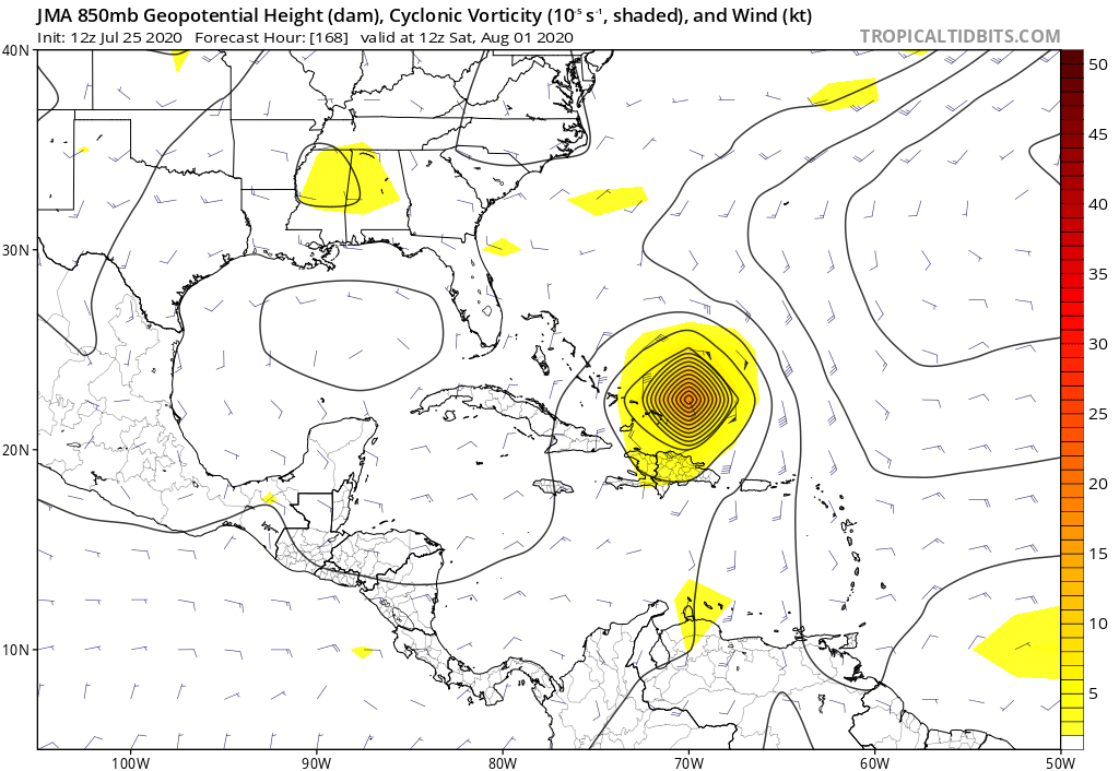
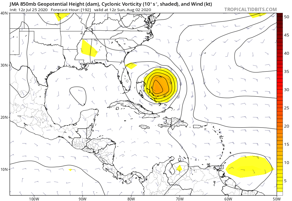
gatorcane wrote:Rarely see the low-res JMA this intense = extremely favorable conditions if this wave makes it there.
But curiously from hours 168 to 192 hours it quite dramatically weakens it though.
https://i.postimg.cc/xT38RDfN/jma-z850-vort-watl-8.png
https://i.postimg.cc/9QNW8cv0/jma-z850-vort-watl-9.png

abajan wrote:plasticup wrote:gatorcane wrote:Remarkably tight consensus:
https://i.postimg.cc/4yvMr1yw/92-L-tracks-18z.png
https://i.postimg.cc/YCCVsYHf/92-L-intensity-18z.png
Breathing a sigh of relief here in Bermuda.
I'm afraid it's too early for that.


HurricaneFrances04 wrote:Will be interesting if any ensembles show something similar
https://i.imgur.com/ITDdMEZ.gif
OuterBanker wrote:3 The Outer Banks hasn't had a landfalling hurricane since Dorian.


Users browsing this forum: No registered users and 17 guests


