ATL: FAY - Post-Tropical - Discussion
Moderator: S2k Moderators
-
HurricaneEnzo

- Category 2

- Posts: 743
- Joined: Wed Mar 14, 2018 12:18 pm
- Location: Newport, NC (Hurricane Alley)
Re: ATL: INVEST 98L - Discussion
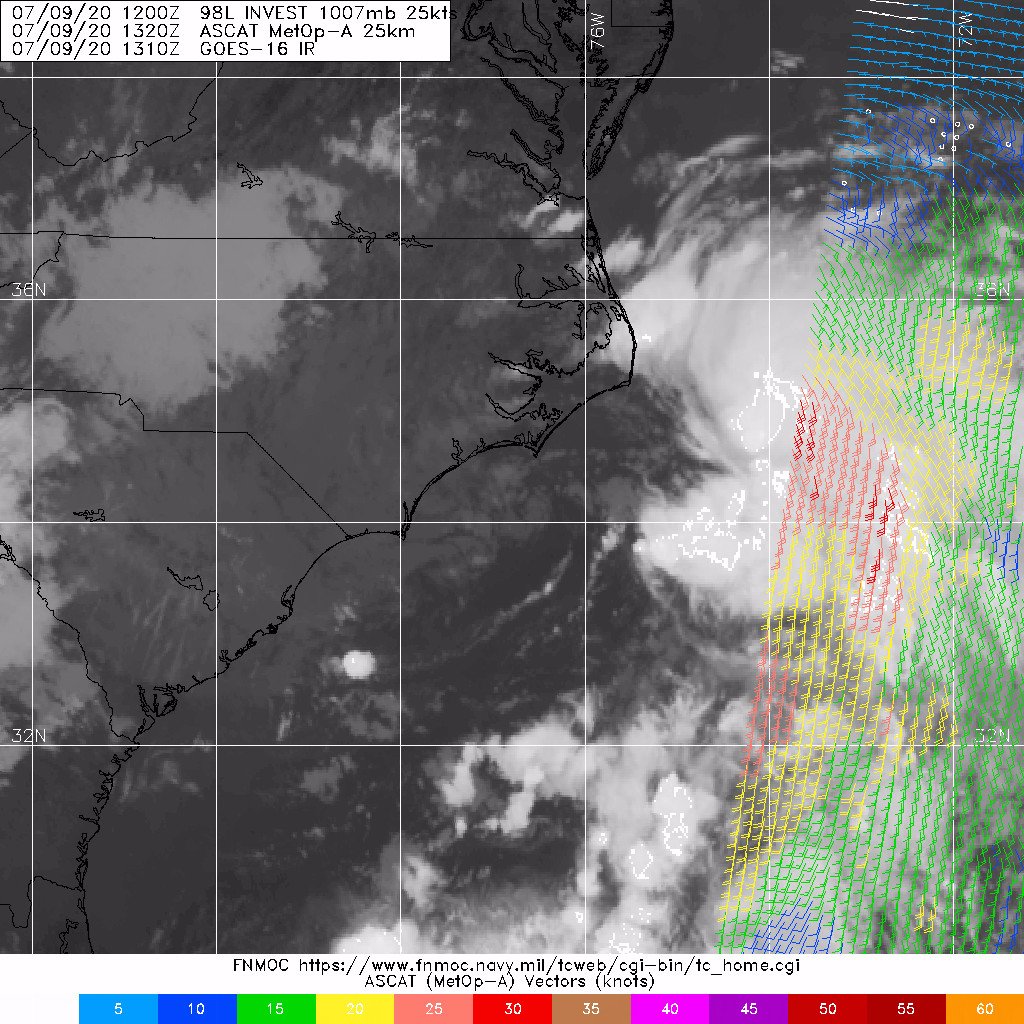
Looking at the visible loop more closely I am on board with a center relocation to the east of the big naked circ. Right around 74.5W and 34.2N. The big circ closer to the coast looks to be elongating.
3 likes
Bertha 96' - Fran 96' - Bonnie 98' - Dennis 99' - Floyd 99' - Isabel 03' - Alex 04' - Ophelia 05' - Irene 11' - Arthur 14' - Matthew 16' - Florence 18' - Dorian 19' - Isaias 20' (countless other tropical storms and Hurricane swipes)
I am not a Professional Met just an enthusiast. Get your weather forecasts from the Pros!
I am not a Professional Met just an enthusiast. Get your weather forecasts from the Pros!
-
Nancy Smar

- Category 5

- Posts: 1081
- Age: 25
- Joined: Wed Aug 16, 2017 10:03 pm
-
gfsperpendicular

- Category 1

- Posts: 383
- Age: 21
- Joined: Mon Jun 19, 2017 3:04 pm
- Location: Northern Virginia
Re: ATL: INVEST 98L - Discussion
Convection wrapping into the new center perhaps?

0 likes
I'm not sleeping, I'm waiting for the 0900 UTC advisory!
#1 CMC stan
#1 CMC stan
-
cycloneye

- Admin

- Posts: 149275
- Age: 69
- Joined: Thu Oct 10, 2002 10:54 am
- Location: San Juan, Puerto Rico
Re: ATL: INVEST 98L - Discussion
Recon is flying to 98L.

2 likes
Visit the Caribbean-Central America Weather Thread where you can find at first post web cams,radars
and observations from Caribbean basin members Click Here
and observations from Caribbean basin members Click Here
-
Aric Dunn
- Category 5
- Posts: 21238
- Age: 43
- Joined: Sun Sep 19, 2004 9:58 pm
- Location: Ready for the Chase.
- Contact:
Re: ATL: INVEST 98L - Discussion
The fact that shear is dropping fast and becoming very divergent would not be good if this had more time over warm water.
luckily it will be over cooler water by tomorrow...
luckily it will be over cooler water by tomorrow...
3 likes
Note: If I make a post that is brief. Please refer back to previous posts for the analysis or reasoning. I do not re-write/qoute what my initial post said each time.
If there is nothing before... then just ask
Space & Atmospheric Physicist, Embry-Riddle Aeronautical University,
I believe the sky is falling...
If there is nothing before... then just ask
Space & Atmospheric Physicist, Embry-Riddle Aeronautical University,
I believe the sky is falling...
-
Nancy Smar
- Category 5
- Posts: 1081
- Age: 25
- Joined: Wed Aug 16, 2017 10:03 pm

-
Aric Dunn
- Category 5
- Posts: 21238
- Age: 43
- Joined: Sun Sep 19, 2004 9:58 pm
- Location: Ready for the Chase.
- Contact:
Re: ATL: INVEST 98L - Discussion
if recon ( most likely will) finds a well defined enough circ under the convection it will probably go straight to TS Fay.
quite a few TS force doppler velocities have been showing up in the deeper convection. some of that is likely translating to the surface.
quite a few TS force doppler velocities have been showing up in the deeper convection. some of that is likely translating to the surface.
1 likes
Note: If I make a post that is brief. Please refer back to previous posts for the analysis or reasoning. I do not re-write/qoute what my initial post said each time.
If there is nothing before... then just ask
Space & Atmospheric Physicist, Embry-Riddle Aeronautical University,
I believe the sky is falling...
If there is nothing before... then just ask
Space & Atmospheric Physicist, Embry-Riddle Aeronautical University,
I believe the sky is falling...
-
OuterBanker
- S2K Supporter

- Posts: 1761
- Joined: Wed Feb 26, 2003 10:53 am
- Location: Nags Head, NC
- Contact:
Re: ATL: INVEST 98L - Discussion
This morning around 6 it was sunny with lots of beautiful cumulus around. Around 10 am the main convection to the east was just making it to shore and we received some rain. Yesterday I was thinking that at least the OBX would escape any affects and the rain and bad weather would stay offshore. The llc just east of Wilmington is stubborn and I thought it would dissipate or slip under the convection off shore. So far that has not happened. It does appear that the CDO east of Hatteras just might happen and take over, but I’m just not sure. What it looks like to me is that it will consolidate somewhere in the middle between the current CDO off Cape Hatteras and the llc off Wilmington. In other words right on top of Cape Hatteras.
1 likes
-
cycloneye
- Admin
- Posts: 149275
- Age: 69
- Joined: Thu Oct 10, 2002 10:54 am
- Location: San Juan, Puerto Rico
Re: ATL: INVEST 98L - Discussion
0 likes
Visit the Caribbean-Central America Weather Thread where you can find at first post web cams,radars
and observations from Caribbean basin members Click Here
and observations from Caribbean basin members Click Here

Re: ATL: INVEST 98L - Discussion
That outflow boundary, from the convective burst that fired this morning over the Outer Banks, did hit the feeder band and fire off some minimal convection to the NE of the CoC.
Doesn't look like it was enough to cause any damage though.

Doesn't look like it was enough to cause any damage though.
0 likes
Re: ATL: INVEST 98L - Discussion
Popups starting to build over the east end of the state.
Its like watching grass grow.

Its like watching grass grow.
0 likes
-
wxman57

- Moderator-Pro Met

- Posts: 23172
- Age: 68
- Joined: Sat Jun 21, 2003 8:06 pm
- Location: Houston, TX (southwest)
Re: ATL: INVEST 98L - Discussion
Although the LLC near the OBX appears to be dissipating, I don't see a significant enough LLC farther east to warrant an upgrade. May have to wait until tomorrow morning. I'm still very surprised the NHC isn't issuing PTC Six advisories. BIG split in the models and ensembles, by the way. GFS into southern NJ by noon tomorrow, EC ensembles and operational to RI or southern MA late on Saturday.
2 likes
-
storminabox
- Category 1
- Posts: 263
- Joined: Sun Jul 09, 2017 10:50 pm
Re: ATL: INVEST 98L - Discussion
Steve wrote:Blow-up right now seems to be mostly off the NC Coast on IR. It almost looks shear induced, but that could be the eastern side of one of the circulations rotating around the low pressure area. IDK.
https://cdn.star.nesdis.noaa.gov//GOES1 ... 0x1000.gif
There are still differences in the models. GFS pretty much hits Delaware and goes up sort of through Philly/New Jersey into New York. It doesn't get strong - 1004, but it shows some weather rotating through it here and there. GFS doesn't really get it much off the coast, and it initializes off the NC Coast. ICON still mostly stays offshore and hits Long Island a couple mb deeper than the GFS gets. NAM 3km takes it to south Jersey Friday around noon in the 998/997mb range. 12km is about 1003mb at Long Island; 32km is about the same as the 12km but faster.
Luckily it won't be a vicious hit. You don't ever want to see a major take the likely track toward Delaware or southern NJ through Philly, NY, Long Island and all points east and above. That's a lot of impact. Hopefully everyone up that way gets to enjoy a day or two of squalls and feeder bands without any damage or losing power.
I for one, live in Eastern New England, and am excited to get a TC up in my neck of the woods. The feeder bands coming off the ocean should be quite fun to experience. Hopefully there are no tornadoes though.
3 likes
-
wxman57
- Moderator-Pro Met
- Posts: 23172
- Age: 68
- Joined: Sat Jun 21, 2003 8:06 pm
- Location: Houston, TX (southwest)
Re: ATL: INVEST 98L - Discussion
storminabox wrote:
I for one, live in Eastern New England, and am excited to get a TC up in my neck of the woods. The feeder bands coming off the ocean should be quite fun to experience. Hopefully there are no tornadoes though.
This storm may be too disorganized to produce much up your way. A bit of rain and not much wind, but I wouldn't expect any tornadoes. You see a lot worse every week in the winter.
2 likes
-
Hypercane_Kyle

- Category 5
- Posts: 3465
- Joined: Sat Mar 07, 2015 7:58 pm
- Location: Cape Canaveral, FL
Re: ATL: INVEST 98L - Discussion
Looks like a vaguely tropical mess to me. Might get a pass as a subtropical depression, before moving inland.
As mentioned, if named "Fay" it'll absolutely crush the previous record for earliest sixth named storm.
As mentioned, if named "Fay" it'll absolutely crush the previous record for earliest sixth named storm.
1 likes
My posts are my own personal opinion, defer to the National Hurricane Center (NHC) and other NOAA products for decision making during hurricane season.
-
wxman57
- Moderator-Pro Met
- Posts: 23172
- Age: 68
- Joined: Sat Jun 21, 2003 8:06 pm
- Location: Houston, TX (southwest)
Re: ATL: INVEST 98L - Discussion
I see a 40kt easterly FL wind, but surface obs suggest these winds are not making it down to the surface. By the way, I do think it will be Fay, and I don't believe the GFS at all. Center will reform well east of the GFS' track. Consensus "model" is being pulled too far west by the GFS. Consensus (TVCN) has the center inland over eastern NC 21Z, and I'm not talking about inland being the OBX. It's way too far west. Center appears to be reforming about 60 miles east of the TVCN track.
7 likes
-
cycloneye
- Admin
- Posts: 149275
- Age: 69
- Joined: Thu Oct 10, 2002 10:54 am
- Location: San Juan, Puerto Rico
Re: ATL: INVEST 98L - Discussion
Tropical Weather Outlook
NWS National Hurricane Center Miami FL
200 PM EDT Thu Jul 9 2020
For the North Atlantic...Caribbean Sea and the Gulf of Mexico:
1. Shower and thunderstorm activity associated with a low pressure area
located near the Outer Banks of North Carolina has continued to
increase and is showing signs of organization. Recent satellite
and radar imagery, along with surface observations and data from an
Air Force Reserve reconnaissance aircraft that is just beginning to
investigate the system, suggest that a new center of circulation
could be forming east of Cape Hatteras. If these development trends
continue, this system is likely to become a tropical depression or
storm later today or tonight. The low is expected to move north-
northeastward along the mid-Atlantic coast tonight through
Friday night.
Regardless of development, the system is expected to produce
locally heavy rainfall that could cause some flash flooding across
portions of eastern North Carolina, the coastal mid-Atlantic, and
southern New England during the next few days. Gusty winds are also
possible along the North Carolina Outer Banks today, and along
the mid-Atlantic and southern New England coasts Friday and
Saturday. Interests in these areas should monitor the progress of
this system and refer to products from your local National Weather
Service office.
* Formation chance through 48 hours...high...90 percent.
* Formation chance through 5 days...high...90 percent.
Forecaster Brown
0 likes
Visit the Caribbean-Central America Weather Thread where you can find at first post web cams,radars
and observations from Caribbean basin members Click Here
and observations from Caribbean basin members Click Here
-
toad strangler

- S2K Supporter
- Posts: 4546
- Joined: Sun Jul 28, 2013 3:09 pm
- Location: Earth
- Contact:
-
wxman57
- Moderator-Pro Met
- Posts: 23172
- Age: 68
- Joined: Sat Jun 21, 2003 8:06 pm
- Location: Houston, TX (southwest)
Re: ATL: INVEST 98L - Discussion
12Z Euro has the center near 35.5N / 75W at 18Z (close to where recon is finding a center forming), while the 12Z GFS has it about 100 miles southwest of there near 34.4N / 76.5W. The GFS appears to be following the dissipating LLC. It's way off in its initialization.
8 likes

Re: ATL: INVEST 98L - Discussion
It looks like it's carrying on with the trend it telegraphed yesterday by reforming off the NC Coast. HRRR takes it quickly to the Delmarva Peninsula and has it at 1002mb in about 18 hours. That would be several millibars drop though obviously not anything like rapid intensification. We'll see if it can't ramp up a little overnight and maybe keep some of the convection overtop instead of blowing off to the east.
2 likes
Who is online
Users browsing this forum: No registered users and 129 guests