ATL: SALLY - Models

Moderator: S2k Moderators

Message
Author
User avatar
Hypercane_Kyle
Category 5
Category 5
Posts: 3352
Joined: Sat Mar 07, 2015 7:58 pm
Location: Cape Canaveral, FL

Re: ATL: SALLY - Models

#321 Postby Hypercane_Kyle » Sun Sep 13, 2020 1:41 am

Steve wrote:
PTPatrick wrote:
Hypercane_Kyle wrote:
Yes, but the Euro/GFS won't resolve this as a potential hurricane threat until it's actually a hurricane. Best to focus on track now.


I guess that’s why i question them...are the just west because they see it as staying weak. Maybe that’s what happens but how much of their track is the product if then resolving a weak storm


They're not weak per se'. They take it to Cat 1. HWRF is also in their neighborhood though much, much stronger. NAMs as well.


Looking at the Hi-res Euro, strongest winds I could find were like 45 knots.
1 likes   
My posts are my own personal opinion, defer to the National Hurricane Center (NHC) and other NOAA products for decision making during hurricane season.

User avatar
Steve
S2K Supporter
S2K Supporter
Posts: 9620
Joined: Sat Apr 05, 2003 11:41 pm
Location: Not a state-caster

Re: ATL: SALLY - Models

#322 Postby Steve » Sun Sep 13, 2020 1:56 am

Seems strange all things - and pressure considered. 45 knots is still powerful, but it's hardly the 110 HWRF showed. Based on what it is now and what it is likely to be Monday afternoon, it's probably somewhere in the middle.
1 likes   

User avatar
kevin
Category 5
Category 5
Posts: 2586
Age: 26
Joined: Wed Aug 28, 2019 4:35 am

Re: ATL: SALLY - Models

#323 Postby kevin » Sun Sep 13, 2020 2:38 am

Just saw in the discussion thread that recon measured 1000 mbar and an estimated 52 kts SFMR. If we look at what yesterday's 18z models (12z for CMC) forecasted for now (I took the average of 06z/09z UTC data points) you get:

HWRF = 1000 mbar, 46 kts
HMON = 1002 mbar, 39 kts
GFS = 1003 mbar, 33 kts
ICON = 1004 mbar, 32 kts
CMC = 1005 mbar, 32 kts

Am I missing something or are all the models way too slow with intensifying Sally (even in the short term) besides HWRF? If so, that's very bad news.
Last edited by kevin on Sun Sep 13, 2020 2:39 am, edited 2 times in total.
3 likes   

User avatar
Hammy
Category 5
Category 5
Posts: 5849
Age: 41
Joined: Fri May 25, 2012 5:25 pm
Contact:

Re: ATL: SALLY - Models

#324 Postby Hammy » Sun Sep 13, 2020 2:38 am

HWRF still doing fairly well with convection even out at 36 hours.

Image
Image
6 likes   
The above post is not official and should not be used as such. It is the opinion of the poster and may or may not be backed by sound meteorological data. It is not endorsed by any professional institution or storm2k.org. For official information, please refer to the NHC and NWS products.

User avatar
eastcoastFL
Category 5
Category 5
Posts: 3901
Age: 43
Joined: Thu Apr 12, 2007 12:29 pm
Location: Palm City, FL

Re: ATL: SALLY - Models

#325 Postby eastcoastFL » Sun Sep 13, 2020 3:25 am

Steve wrote:Seems strange all things - and pressure considered. 45 knots is still powerful, but it's hardly the 110 HWRF showed. Based on what it is now and what it is likely to be Monday afternoon, it's probably somewhere in the middle.


That’s about how I feel. It’s all going to depend if there’s any shear down the road in my opinion. She’s starting to get it together this morning and once she gets that core worked out she’ll be ramping up. Hopefully she takes a while to get her act together and runs out of time to become a strong hurricane. Either way it looks like someone is in for some serious flooding down the road no matter how strong it is.
2 likes   
Personal Forecast Disclaimer:
The posts in this forum are NOT official forecast and should not be used as such. They are just the opinion of the poster and may or may not be backed by sound meteorological data. They are NOT endorsed by any professional institution or storm2k.org. For official information, please refer to the NHC and NWS products.

User avatar
eastcoastFL
Category 5
Category 5
Posts: 3901
Age: 43
Joined: Thu Apr 12, 2007 12:29 pm
Location: Palm City, FL

Re: ATL: SALLY - Models

#326 Postby eastcoastFL » Sun Sep 13, 2020 3:27 am

Hammy wrote:HWRF still doing fairly well with convection even out at 36 hours.

https://i.imgur.com/jkwgDOA.png
https://i.imgur.com/kP7LorA.png


Hwrf has been really impressive this season with forecasting the structural and IR presentation

Let’s hope this part doesn’t verify


Image
5 likes   
Personal Forecast Disclaimer:
The posts in this forum are NOT official forecast and should not be used as such. They are just the opinion of the poster and may or may not be backed by sound meteorological data. They are NOT endorsed by any professional institution or storm2k.org. For official information, please refer to the NHC and NWS products.

User avatar
eastcoastFL
Category 5
Category 5
Posts: 3901
Age: 43
Joined: Thu Apr 12, 2007 12:29 pm
Location: Palm City, FL

Re: ATL: SALLY - Models

#327 Postby eastcoastFL » Sun Sep 13, 2020 3:35 am

I think once Sally gets a more defined center the models may start to tick up on intensity. I’m looking at the shear map and there’s an anti cyclone over the GOM and not much shear at all. I’m having a hard time believing she won’t push at least a cat 2 in these conditions given that she’ll have another 60ish hours over water.
1 likes   
Personal Forecast Disclaimer:
The posts in this forum are NOT official forecast and should not be used as such. They are just the opinion of the poster and may or may not be backed by sound meteorological data. They are NOT endorsed by any professional institution or storm2k.org. For official information, please refer to the NHC and NWS products.

User avatar
eastcoastFL
Category 5
Category 5
Posts: 3901
Age: 43
Joined: Thu Apr 12, 2007 12:29 pm
Location: Palm City, FL

Re: ATL: SALLY - Models

#328 Postby eastcoastFL » Sun Sep 13, 2020 6:11 am

As expected models are starting to tick upwards on intensity now that Sally is more developed and picking up steam.

06z Icon coming into Nola in the 980s

Image


06z HMON

Image
1 likes   
Personal Forecast Disclaimer:
The posts in this forum are NOT official forecast and should not be used as such. They are just the opinion of the poster and may or may not be backed by sound meteorological data. They are NOT endorsed by any professional institution or storm2k.org. For official information, please refer to the NHC and NWS products.

Javlin
Category 5
Category 5
Posts: 1620
Age: 64
Joined: Fri Jul 09, 2004 7:58 pm
Location: ms gulf coast

Re: ATL: SALLY - Models

#329 Postby Javlin » Sun Sep 13, 2020 6:22 am

HMON has it coming in on top of mine and FrankP's house 88.9W we'll see if that verifies strange kick W after landfall(?)
1 likes   

User avatar
gatorcane
S2K Supporter
S2K Supporter
Posts: 23691
Age: 47
Joined: Sun Mar 13, 2005 3:54 pm
Location: Boca Raton, FL

Re: ATL: SALLY - Models

#330 Postby gatorcane » Sun Sep 13, 2020 6:42 am

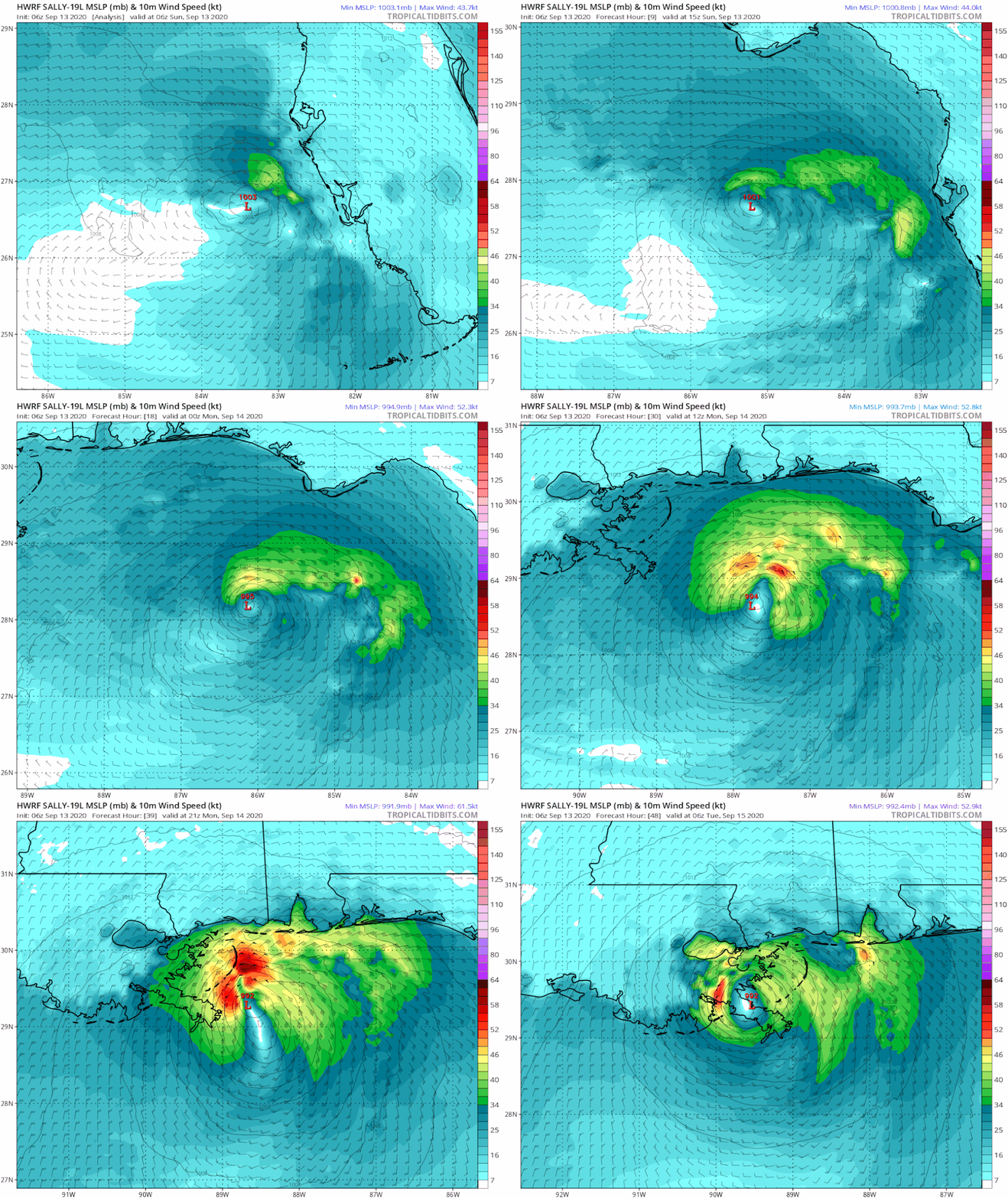
06Z HWRF is much weaker for some reason:

Image
1 likes   

Shell Mound
Category 5
Category 5
Posts: 2434
Age: 32
Joined: Thu Sep 07, 2017 3:39 pm
Location: St. Petersburg, FL → Scandinavia

Re: ATL: SALLY - Models

#331 Postby Shell Mound » Sun Sep 13, 2020 6:50 am

gatorcane wrote:06Z HWRF is much weaker for some reason:

https://i.postimg.cc/T1g9Mqrt/hwrf-mslp-wind-19-L-fh0-48.gif

Based on simulated IR imagery, the UL anticyclone looks to be more displaced on the 06Z vs. the 18Z/00Z runs, resulting in much higher VWS.
0 likes   
CVW / MiamiensisWx / Shell Mound
The posts in this forum are NOT official forecasts and should not be used as such. They are just the opinion of the poster and may or may not be backed by sound meteorological data. They are NOT endorsed by any professional institution or STORM2K. For official information, please refer to products from the NHC and NWS.

shiny-pebble
Category 1
Category 1
Posts: 299
Joined: Thu Jul 05, 2018 1:38 pm

Re: ATL: SALLY - Models

#332 Postby shiny-pebble » Sun Sep 13, 2020 6:56 am

1 likes   
Not an meteorologist! Just someone who is interested in weather. Please refer to the NHC and local weather officials to make decisions.
-Jack 8-)

Shell Mound
Category 5
Category 5
Posts: 2434
Age: 32
Joined: Thu Sep 07, 2017 3:39 pm
Location: St. Petersburg, FL → Scandinavia

Re: ATL: SALLY - Models

#333 Postby Shell Mound » Sun Sep 13, 2020 7:07 am


I suspect that the 12Z run of the HWRF may be much more revealing, with new data ingested by then. Perhaps it will show the strongest solution yet.
1 likes   
CVW / MiamiensisWx / Shell Mound
The posts in this forum are NOT official forecasts and should not be used as such. They are just the opinion of the poster and may or may not be backed by sound meteorological data. They are NOT endorsed by any professional institution or STORM2K. For official information, please refer to products from the NHC and NWS.

jlauderdal
S2K Supporter
S2K Supporter
Posts: 7182
Joined: Wed May 19, 2004 5:46 am
Location: NE Fort Lauderdale
Contact:

Re: ATL: SALLY - Models

#334 Postby jlauderdal » Sun Sep 13, 2020 7:34 am

gatorcane wrote:06Z HWRF is much weaker for some reason:

https://i.postimg.cc/T1g9Mqrt/hwrf-mslp-wind-19-L-fh0-48.gif
slow down, land interaction..cant be discounted but the bigger issue for New Orleans very well could be the precip
0 likes   

User avatar
Blown Away
S2K Supporter
S2K Supporter
Posts: 10145
Joined: Wed May 26, 2004 6:17 am

Re: ATL: SALLY - Models

#335 Postby Blown Away » Sun Sep 13, 2020 7:42 am

jlauderdal wrote:
gatorcane wrote:06Z HWRF is much weaker for some reason:

https://i.postimg.cc/T1g9Mqrt/hwrf-mslp-wind-19-L-fh0-48.gif
slow down, land interaction..cant be discounted but the bigger issue for New Orleans very well could be the precip


06z intensity guidance down this run with most barely reaching Cat 1 status... Kind of a weird angle going WNW a few hundred miles S of the NGOM Coast from Fl peninsula to central LA then a very sharp NE turn after landfall, that usually means increasing shear... Let’s see if NHC maybe backs off intensity a little today...
Last edited by Blown Away on Sun Sep 13, 2020 8:04 am, edited 1 time in total.
0 likes   
Hurricane Eye Experience: David 79, Irene 99, Frances 04, Jeanne 04, Wilma 05... EYE COMING MY WAY IN 2024…
Hurricane Brush Experience: Andrew 92, Erin 95, Floyd 99, Matthew 16, Irma 17, Ian 22, Nicole 22…

User avatar
kevin
Category 5
Category 5
Posts: 2586
Age: 26
Joined: Wed Aug 28, 2019 4:35 am

Re: ATL: SALLY - Models

#336 Postby kevin » Sun Sep 13, 2020 7:45 am

Didn't expect 06z HWRF to be so weak. Will be interesting to see the 12z run to see whether this was a fluke. Usually I'd feel pretty safe if even HWRF starts weakening, but it seems it initialized way too weak as far as I can see. The current intensity according to NHC is 996 mbar and yet the HWRF doesn't reach that pressure until 18 hours from now.
1 likes   

User avatar
eastcoastFL
Category 5
Category 5
Posts: 3901
Age: 43
Joined: Thu Apr 12, 2007 12:29 pm
Location: Palm City, FL

Re: ATL: SALLY - Models

#337 Postby eastcoastFL » Sun Sep 13, 2020 8:24 am

jlauderdal wrote:
gatorcane wrote:06Z HWRF is much weaker for some reason:

https://i.postimg.cc/T1g9Mqrt/hwrf-mslp-wind-19-L-fh0-48.gif
slow down, land interaction..cant be discounted but the bigger issue for New Orleans very well could be the precip


You nailed it. Whether there’s a major wind event or not the rainfall accumulation is going to be the kicker. We have multiple models now calling for 2-3ft of rain total in the Nola and SW MS areas. That’s not something you want to see for New Orleans

Image
1 likes   
Personal Forecast Disclaimer:
The posts in this forum are NOT official forecast and should not be used as such. They are just the opinion of the poster and may or may not be backed by sound meteorological data. They are NOT endorsed by any professional institution or storm2k.org. For official information, please refer to the NHC and NWS products.

TimSmith
S2K Supporter
S2K Supporter
Posts: 15
Joined: Tue Aug 25, 2020 10:21 am

Re: ATL: SALLY - Models

#338 Postby TimSmith » Sun Sep 13, 2020 8:48 am

kevin wrote:Just saw in the discussion thread that recon measured 1000 mbar and an estimated 52 kts SFMR. If we look at what yesterday's 18z models (12z for CMC) forecasted for now (I took the average of 06z/09z UTC data points) you get:

HWRF = 1000 mbar, 46 kts
HMON = 1002 mbar, 39 kts
GFS = 1003 mbar, 33 kts
ICON = 1004 mbar, 32 kts
CMC = 1005 mbar, 32 kts

Am I missing something or are all the models way too slow with intensifying Sally (even in the short term) besides HWRF? If so, that's very bad news.


This is very interesting & might have something to do with the initial data fed into the models, and I'd expect the 12z models we'll see this afternoon will give a much clearly picture. I'm not sure of the exact details, but if I'm not mistaken I believe the HWRF is more fine mesh mathematically about the center of the storm while the others are more wider sort of global. The issue here might be that the others were initially reading that yesterday afternoon was either over land or some interaction with land so didn't intensify as quickly, but really that "land" actually had fuel in it; this data of initial conditions is so so important as the underlying equations that model are extremely sensitive to small changes in their initial value conditions. Anyways, we'll get a much clearer picture comparing the 0z runs to today's 12z to look the trends...
4 likes   

User avatar
LowerAlabamaTider
Tropical Storm
Tropical Storm
Posts: 111
Age: 65
Joined: Thu Aug 20, 2020 1:08 pm

Re: ATL: SALLY - Models

#339 Postby LowerAlabamaTider » Sun Sep 13, 2020 10:08 am

11AM from NHC has nudged landfall a tad further west. Looking like Sally May be headed to the Big Easy for sure.
1 likes   

User avatar
PTPatrick
Category 5
Category 5
Posts: 1831
Joined: Sat Jun 12, 2004 8:38 am

Re: ATL: SALLY - Models

#340 Postby PTPatrick » Sun Sep 13, 2020 10:13 am

12z icon still offshore of the mouth at 51. At 63 drifting north just east chandeleur islands. This is why I don’t trust any real west model swings yet...when steering slows they can do anything. Waiting for 12z suite and guidance to help determine what all the family should do, this is a tough one.

Edit, ends in landfall Dauphin island at 72 hrs.
0 likes   


Return to “2020”

Who is online

Users browsing this forum: No registered users and 3 guests