ATL: ETA - Models
Moderator: S2k Moderators
-
AutoPenalti
- Category 5

- Posts: 4091
- Age: 29
- Joined: Mon Aug 17, 2015 4:16 pm
- Location: Ft. Lauderdale, Florida
Re: ATL: INVEST 96L - Models
A piece breaking off CA would tend to have a weaker solution moving north, I would wager a minimal TS at best.
1 likes
The posts in this forum are NOT official forecasts and should not be used as such. They are just the opinion of the poster and may or may not be backed by sound meteorological data. They are NOT endorsed by any professional institution or STORM2K. For official information, please refer to products from the NHC and NWS.
Model Runs Cheat Sheet:
GFS (5:30 AM/PM, 11:30 AM/PM)
HWRF, GFDL, UKMET, NAVGEM (6:30-8:00 AM/PM, 12:30-2:00 AM/PM)
ECMWF (1:45 AM/PM)
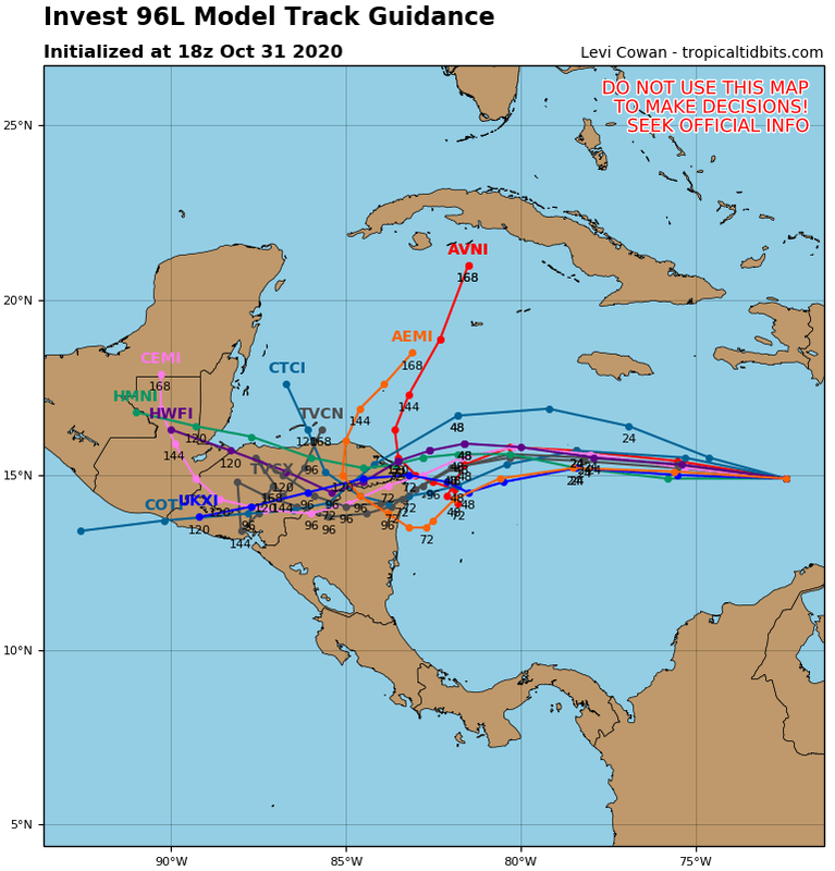
TCVN is a weighted averaged
-
Blown Away

- S2K Supporter

- Posts: 10253
- Joined: Wed May 26, 2004 6:17 am
Re: ATL: INVEST 96L - Models
12z HWRF 3 degrees N at @120hrs... Still goes into CA @84 hrs, but a much sharper N turn through 120 hrs... If HWRF continues to trend N it will be close to or off N coast of CA...
1 likes
Hurricane Eye Experience: David 79, Irene 99, Frances 04, Jeanne 04, Wilma 05… Hurricane Brush Experience: Andrew 92, Erin 95, Floyd 99, Matthew 16, Irma 17, Ian 22, Nicole 22…
-
TheProfessor

- Professional-Met

- Posts: 3506
- Age: 29
- Joined: Tue Dec 03, 2013 10:56 am
- Location: Wichita, Kansas
Re: ATL: INVEST 96L - Models
As always it's usually smart to go somewhere in the middle. In certain setups it doesn't always playout that way, though this time there does seem to be a case of an in between (Models like the HMON that landfall and then move wnw towards Belize). The Euro, EPS, and Ukie both have west biases and if a shortwave trough is in play they both tend to amplify them too much. The GFS is the opposite and it tends to be too progressive with these troughs so it's likely a bit too far east. Believe it or not we could another storm wind up in the Gulf after hitting CA and being pulled up towards the Yucatan. That is if we believe the shortwave trough to be slower than what the GFS shows but faster than what the Euro shows. I will say that it's more concerning for Florida that many of the GEFS members are east of the state as just like I mentioned before, the GFS is likely too quick with the shortwave.
3 likes
An alumnus of The Ohio State University.
Your local National Weather Service office is your best source for weather information.
Your local National Weather Service office is your best source for weather information.
-
TheStormExpert
Re: ATL: INVEST 96L - Models
NDG wrote:gatorcane wrote:Euro dives SW into Honduras/Nicaragua again. The model is very consistent with this.
https://i.postimg.cc/25vrzBfM/ecmwf-uv850-vort-watl-fh0-72.gif
What doesn't make sense is that it keeps forecasting it to go into the EPAC and for another system to form in the Caribbean side of C.A., it doesn't make any sense. I have never seen that before.
Is either one or the other.
How does that not make sense? It’s November with a ridge over the Gulf and Florida with a tropical system sliding west or southwest into CA. Think Otto from November 2016 as a perfect example.
0 likes
-
TheStormExpert
Re: ATL: INVEST 96L - Models
So it’s the GFS verses the Euro now. What a show! 
I’d be leaning more towards the Euro especially on track as the GFS almost always overdoes troughiness and we’re in a +NAO, not a negative.
Now if the Euro comes around to the GFS overnight or something then I’ll began to raise an eyebrow.
I’d be leaning more towards the Euro especially on track as the GFS almost always overdoes troughiness and we’re in a +NAO, not a negative.
Now if the Euro comes around to the GFS overnight or something then I’ll began to raise an eyebrow.
0 likes
-
Loveweather12
- Tropical Storm

- Posts: 136
- Joined: Thu Aug 20, 2020 2:37 pm
Re: ATL: INVEST 96L - Models
gatorcane wrote:
I remember a similar map with Zeta. The place to be with the GFS is 7+ days out. The chance of it nailing the forecast is slim to none.
The same can be said about the euro too.
0 likes
-
cp79
Re: ATL: INVEST 96L - Models
AutoPenalti wrote:A piece breaking off CA would tend to have a weaker solution moving north, I would wager a minimal TS at best.
Yup I don’t know if it would crank up. Euro turns it into a TS but then blasts it off ENE towards the Atlantic which is what I would expect this time of year.
0 likes


-
CyclonicFury

- Category 5
- Posts: 2032
- Age: 27
- Joined: Sun Jul 02, 2017 12:32 pm
- Location: NC
- Contact:
Re: ATL: INVEST 96L - Models
This reminds me of the early Cristobal model runs that suggested a second storm would form out of the CAG, when in reality Cristobal remained one entity.
2 likes
NCSU B.S. in Meteorology Class of 2021. Tropical weather blogger at http://www.cyclonicfury.com. My forecasts and thoughts are NOT official, for official forecasts please consult the National Hurricane Center.
-
Shell Mound
- Category 5
- Posts: 2432
- Age: 33
- Joined: Thu Sep 07, 2017 3:39 pm
- Location: St. Petersburg, FL → Scandinavia
Re: ATL: INVEST 96L - Models
Blown Away wrote:12z HWRF 3 degrees N at @120hrs... Still goes into CA @84 hrs, but a much sharper N turn through 120 hrs... If HWRF continues to trend N it will be close to or off N coast of CA...
Actually, close inspection suggests that the 12Z HWRF essentially shows dissipation well inland over mountainous terrain. But 96L is crawling all the way.
2 likes
CVW / MiamiensisWx / Shell Mound
The posts in this forum are NOT official forecasts and should not be used as such. They are just the opinion of the poster and may or may not be backed by sound meteorological data. They are NOT endorsed by any professional institution or STORM2K. For official information, please refer to products from the NHC and NWS.
-
northjaxpro

- S2K Supporter
- Posts: 8900
- Joined: Mon Sep 27, 2010 11:21 am
- Location: Jacksonville, FL
Re: ATL: INVEST 96L - Models
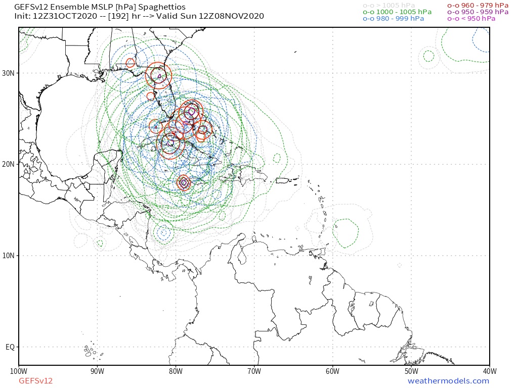
More model wars folks I thought we had made it past the old days back on Storm2K with this.back and forth with the GFS and EURO. Oh well, what an interesting next 7 days or so we have ahead for us.
.
.
0 likes
NEVER, EVER SAY NEVER in the tropics and weather in general, and most importantly, with life itself!!
________________________________________________________________________________________
Fay 2008 Beryl 2012 Debby 2012 Colin 2016 Hermine 2016 Julia 2016 Matthew 2016 Irma 2017 Dorian 2019
________________________________________________________________________________________
Fay 2008 Beryl 2012 Debby 2012 Colin 2016 Hermine 2016 Julia 2016 Matthew 2016 Irma 2017 Dorian 2019
-
Weatherboy1

- Category 5
- Posts: 1190
- Age: 50
- Joined: Mon Jul 05, 2004 1:50 pm
- Location: Jupiter/Sarasota, FL
Re: ATL: INVEST 96L - Models
So according to the Euro, we’re going to end up with THREE areas of vorticity - one in EPAC, one heading ENE over Cuba and one heading NW into the Gulf? Ummmm okay lol
0 likes
-
AutoPenalti
- Category 5
- Posts: 4091
- Age: 29
- Joined: Mon Aug 17, 2015 4:16 pm
- Location: Ft. Lauderdale, Florida
Re: ATL: INVEST 96L - Models
I would have believed you if the GFS did this, but the Euro? Woah.
0 likes
The posts in this forum are NOT official forecasts and should not be used as such. They are just the opinion of the poster and may or may not be backed by sound meteorological data. They are NOT endorsed by any professional institution or STORM2K. For official information, please refer to products from the NHC and NWS.
Model Runs Cheat Sheet:
GFS (5:30 AM/PM, 11:30 AM/PM)
HWRF, GFDL, UKMET, NAVGEM (6:30-8:00 AM/PM, 12:30-2:00 AM/PM)
ECMWF (1:45 AM/PM)
TCVN is a weighted averaged
-
SFLcane

- S2K Supporter
- Posts: 10281
- Age: 48
- Joined: Sat Jun 05, 2010 1:44 pm
- Location: Lake Worth Florida
Re: ATL: INVEST 96L - Models
Tcvn coming offshore. I get you Gatorcane but we just can’t discount the gfs especially with it’s ensemble support.
3 likes
Re: ATL: INVEST 96L - Models
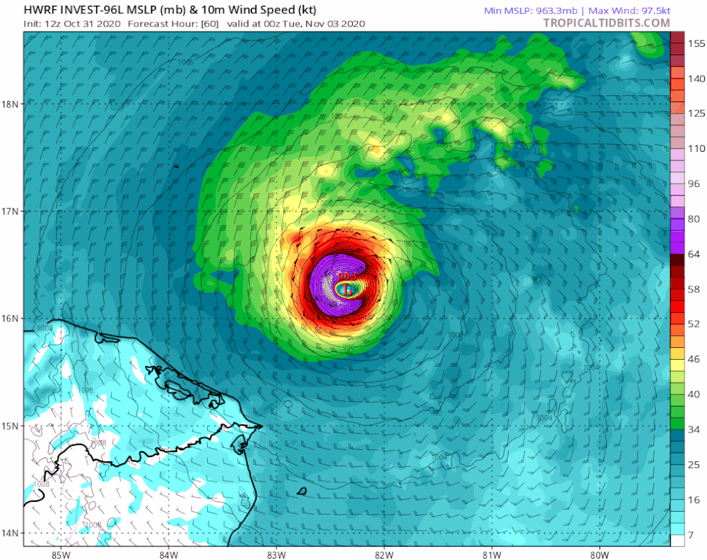
Blown Away wrote:gatorcane wrote:HWRF landfall in Nicaragua heading inland. I wouldn’t get too excited about the GFS into Florida unless more good models show it. Inland into CA looks likely.
https://i.postimg.cc/3JpBF8Y7/hwrf-mslp-wind-96-L-fh60-87.gif
Agree, but the 12z was a full degree N and model has trended N a bit the last few runs.
The HWRF has not trended N the last few runs. It went N of the 6Z only, which itself was a far S outlier vs its prior runs. So, yes, the 12Z is N of the 6Z, but is at hr 96 at 14.7N, 84.9 W, which is still well into CA near the Hond/Nic border moving WSW to that point. At the same time, yes, the 6Z was 55 miles S at 13.9N, 84.9W. But the 0Z was actually further E than 12Z at 14.7N, 84.6W. The 18Z of yest was at 14.7N, 84.8W or about the same place as 12Z. Yest's 12Z was at 14.8N, 83.7W, or way further E than today's 12Z.
12Z HWRF 96 hr

And we can add the JMA to the list of 12Z runs that lingers in/near CA for a long time.
Last edited by LarryWx on Sat Oct 31, 2020 2:20 pm, edited 2 times in total.
0 likes
Personal Forecast Disclaimer:
The posts in this forum are NOT official forecasts and should not be used as such. They are just the opinion of the poster and may or may not be backed by sound meteorological data. They are NOT endorsed by any professional institution or storm2k.org. For official information, please refer to the NHC and NWS products.
The posts in this forum are NOT official forecasts and should not be used as such. They are just the opinion of the poster and may or may not be backed by sound meteorological data. They are NOT endorsed by any professional institution or storm2k.org. For official information, please refer to the NHC and NWS products.
-
gatorcane

- S2K Supporter
- Posts: 23708
- Age: 48
- Joined: Sun Mar 13, 2005 3:54 pm
- Location: Boca Raton, FL
Re: ATL: INVEST 96L - Models
SFLcane wrote:
Tcvn coming offshore. I get you Gatorcane but we just can’t discount the gfs especially with it’s ensemble support.
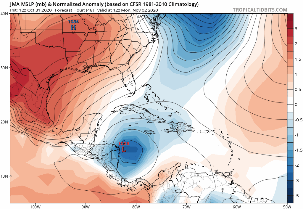
We can’t ignore, some kind of loop might happen, but to get as far north as the GFS has into the Gulf or Florida seems unrealistic. Maybe something closer to the JMA might happen.
JMA:
0 likes

Re: ATL: INVEST 96L - Models
Salute!
With a nice cold front coming down over the Gulf in 3-4 days, why would this sucker turn north?
https://www.wpc.ncep.noaa.gov/medr/9kh.gif
My experience here in the Panhandle has been the storms follow the front to some extent, or at least turn to the east or northeast.
Gums sends...
With a nice cold front coming down over the Gulf in 3-4 days, why would this sucker turn north?
https://www.wpc.ncep.noaa.gov/medr/9kh.gif
My experience here in the Panhandle has been the storms follow the front to some extent, or at least turn to the east or northeast.
Gums sends...
0 likes
-
toad strangler

- S2K Supporter
- Posts: 4546
- Joined: Sun Jul 28, 2013 3:09 pm
- Location: Earth
- Contact:
Re: ATL: INVEST 96L - Models
SFLcane wrote:
Tcvn coming offshore. I get you Gatorcane but we just can’t discount the gfs especially with it’s ensemble support.
Our friend gator loved the GFS when it was spitting out EPAC storms like tic tacs from a pezz dispenser earlier this season
4 likes
My Weather Station
https://www.wunderground.com/dashboard/pws/KFLPORTS603
https://www.wunderground.com/dashboard/pws/KFLPORTS603
-
Blown Away
- S2K Supporter
- Posts: 10253
- Joined: Wed May 26, 2004 6:17 am
Re: ATL: INVEST 96L - Models
SFLcane wrote:
Tcvn coming offshore. I get you Gatorcane but we just can’t discount the gfs especially with it’s ensemble support.
Yep, TVCN first time showing a loop and turn N, difference is it’s well inland CA vs GFS just offshore NE CA. Definitely a big swing compared to TVCN going into EPAC earlier runs. Only talking about a few degrees between CA land interaction and staying offshore in a 72-96 hour window.
1 likes
Hurricane Eye Experience: David 79, Irene 99, Frances 04, Jeanne 04, Wilma 05… Hurricane Brush Experience: Andrew 92, Erin 95, Floyd 99, Matthew 16, Irma 17, Ian 22, Nicole 22…
Who is online
Users browsing this forum: No registered users and 117 guests