
ATL: ETA - Models
Moderator: S2k Moderators
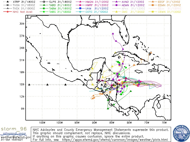
Re: ATL: INVEST 96L - Models
The 12Z HMON is the furthest SW of the last 4 runs at hour 96 just N of the Hond/Nic border:
0 likes
Personal Forecast Disclaimer:
The posts in this forum are NOT official forecasts and should not be used as such. They are just the opinion of the poster and may or may not be backed by sound meteorological data. They are NOT endorsed by any professional institution or storm2k.org. For official information, please refer to the NHC and NWS products.
The posts in this forum are NOT official forecasts and should not be used as such. They are just the opinion of the poster and may or may not be backed by sound meteorological data. They are NOT endorsed by any professional institution or storm2k.org. For official information, please refer to the NHC and NWS products.
-
AutoPenalti
- Category 5

- Posts: 4091
- Age: 29
- Joined: Mon Aug 17, 2015 4:16 pm
- Location: Ft. Lauderdale, Florida
Re: ATL: INVEST 96L - Models
I’ve never seen so many contradictions here, one point saying the GFS is trash, now saying it’s not. People saying GFS was right this will keep heading west and now that it caved to the ensembles, they are now siding with the Euro.
People saying that it’s nearly improbably that this will turn north, now saying it might if it stalls instead of crashing into CA and somehow ending up in the EPAC.
Crazy. I guess that’s why there’s such a thing as a model war.
People saying that it’s nearly improbably that this will turn north, now saying it might if it stalls instead of crashing into CA and somehow ending up in the EPAC.
Crazy. I guess that’s why there’s such a thing as a model war.
4 likes
The posts in this forum are NOT official forecasts and should not be used as such. They are just the opinion of the poster and may or may not be backed by sound meteorological data. They are NOT endorsed by any professional institution or STORM2K. For official information, please refer to products from the NHC and NWS.
Model Runs Cheat Sheet:
GFS (5:30 AM/PM, 11:30 AM/PM)
HWRF, GFDL, UKMET, NAVGEM (6:30-8:00 AM/PM, 12:30-2:00 AM/PM)
ECMWF (1:45 AM/PM)
TCVN is a weighted averaged
-
SFLcane

- S2K Supporter

- Posts: 10281
- Age: 48
- Joined: Sat Jun 05, 2010 1:44 pm
- Location: Lake Worth Florida
Re: ATL: INVEST 96L - Models
toad strangler wrote:SFLcane wrote:
Tcvn coming offshore. I get you Gatorcane but we just can’t discount the gfs especially with it’s ensemble support.
Our friend gator loved the GFS when it was spitting out EPAC storms like tic tacs from a pezz dispenser earlier this season
Indeed.
0 likes
-
AutoPenalti
- Category 5
- Posts: 4091
- Age: 29
- Joined: Mon Aug 17, 2015 4:16 pm
- Location: Ft. Lauderdale, Florida
Re: ATL: INVEST 96L - Models
SFLcane wrote:toad strangler wrote:SFLcane wrote:
Tcvn coming offshore. I get you Gatorcane but we just can’t discount the gfs especially with it’s ensemble support.
Our friend gator loved the GFS when it was spitting out EPAC storms like tic tacs from a pezz dispenser earlier this season
Indeed.lol now it’s trash so let’s disregard it.
GFS is great for forecasting cold fronts that never reach South Florida during the fall.
3 likes
The posts in this forum are NOT official forecasts and should not be used as such. They are just the opinion of the poster and may or may not be backed by sound meteorological data. They are NOT endorsed by any professional institution or STORM2K. For official information, please refer to products from the NHC and NWS.
Model Runs Cheat Sheet:
GFS (5:30 AM/PM, 11:30 AM/PM)
HWRF, GFDL, UKMET, NAVGEM (6:30-8:00 AM/PM, 12:30-2:00 AM/PM)
ECMWF (1:45 AM/PM)
TCVN is a weighted averaged

-
Spacecoast

- Category 2

- Posts: 773
- Joined: Thu Aug 31, 2017 2:03 pm
Re: ATL: INVEST 96L - Models
Blown Away wrote:SFLcane wrote:
Tcvn coming offshore. I get you Gatorcane but we just can’t discount the gfs especially with it’s ensemble support.
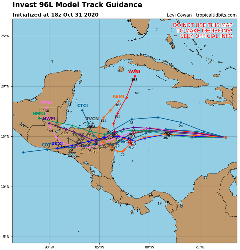
Yep, TVCN first time showing a loop and turn N, difference is it’s well inland CA vs GFS just offshore NE CA. Definitely a big swing compared to TVCN going into EPAC earlier runs. Only talking about a few degrees between CA land interaction and staying offshore in a 72-96 hour window.
Since the TVCN Is consensus of AVNI, EMXI, HWFI, CTCI, HMNI & EGRI, what happens when several of these models disipate?
Isn't this change after 144 hrs more of a reflection of the AVNI being the last model remaining ?
I honestly do not know, so I am just asking so I can understand it better. Thanks.
0 likes
-
SFLcane
- S2K Supporter
- Posts: 10281
- Age: 48
- Joined: Sat Jun 05, 2010 1:44 pm
- Location: Lake Worth Florida
Re: ATL: INVEST 96L - Models
With tcvn now coming offshore instead of going into the epac you get a sense a loop is forthcoming.
Last edited by SFLcane on Sat Oct 31, 2020 2:56 pm, edited 1 time in total.
4 likes

Re: ATL: INVEST 96L - Models
0 likes
-
CyclonicFury

- Category 5
- Posts: 2030
- Age: 27
- Joined: Sun Jul 02, 2017 12:32 pm
- Location: NC
- Contact:
Re: ATL: INVEST 96L - Models
ronjon wrote::uarrow: Hmmm....seems quite a few of the EPS ensembles are now showing the northward turn. Stay tuned...
It actually seems like many of them develop a separate system. Kinda like what models showed for Cristobal earlier this year but that never panned out and it remained one entity
0 likes
NCSU B.S. in Meteorology Class of 2021. Tropical weather blogger at http://www.cyclonicfury.com. My forecasts and thoughts are NOT official, for official forecasts please consult the National Hurricane Center.
-
AutoPenalti
- Category 5
- Posts: 4091
- Age: 29
- Joined: Mon Aug 17, 2015 4:16 pm
- Location: Ft. Lauderdale, Florida
Re: ATL: INVEST 96L - Models
SFLcane wrote:With tcvn now coming offshore instead of going into the epac you get a sense a loop is forthcoming.
https://i.postimg.cc/y85dpmXy/F879-EB09-9-FEE-4757-BD4-C-31766-DC95-BDA.jpg
That’s quite the consensus.
0 likes
The posts in this forum are NOT official forecasts and should not be used as such. They are just the opinion of the poster and may or may not be backed by sound meteorological data. They are NOT endorsed by any professional institution or STORM2K. For official information, please refer to products from the NHC and NWS.
Model Runs Cheat Sheet:
GFS (5:30 AM/PM, 11:30 AM/PM)
HWRF, GFDL, UKMET, NAVGEM (6:30-8:00 AM/PM, 12:30-2:00 AM/PM)
ECMWF (1:45 AM/PM)
TCVN is a weighted averaged
Re: ATL: INVEST 96L - Models
Here is the 7 day 12Z Euro rainfall: there is 12-16" in parts of Hond, Nic, Guat, Costa Rica, and Panama! In NW Hond and E Guat, there is a pretty large area of 16-24"!!
This map is so ominous that 8-12" amounts, which are enough to cause devastating floods and mudslides, don't seem so bad. But even they are bad enough with near 100% of Hond, 60% of Nic/Belize, 30% of Costa Rica, and 40% of Guat covered with 8"+!!
Potentially affected folks in CA, please do whatever you can now to prevent deaths next week in case this verifies. This may need to include preplanning for possible later evacuations of flood prone and mudslide risk areas.
I'm hoping that a board like this can save lives.
Last edited by LarryWx on Sat Oct 31, 2020 3:16 pm, edited 1 time in total.
5 likes
Personal Forecast Disclaimer:
The posts in this forum are NOT official forecasts and should not be used as such. They are just the opinion of the poster and may or may not be backed by sound meteorological data. They are NOT endorsed by any professional institution or storm2k.org. For official information, please refer to the NHC and NWS products.
The posts in this forum are NOT official forecasts and should not be used as such. They are just the opinion of the poster and may or may not be backed by sound meteorological data. They are NOT endorsed by any professional institution or storm2k.org. For official information, please refer to the NHC and NWS products.
-
cp79
Re: ATL: INVEST 96L - Models
ronjon wrote::uarrow: Hmmm....seems quite a few of the EPS ensembles are now showing the northward turn. Stay tuned...
I still think a NE track out to sea in play. Lots of troughs coming down.
0 likes
-
Shell Mound
- Category 5
- Posts: 2432
- Age: 33
- Joined: Thu Sep 07, 2017 3:39 pm
- Location: St. Petersburg, FL → Scandinavia
Re: ATL: INVEST 96L - Models
NDG wrote:https://i.imgur.com/yK7hboq.png
“But...but...the EPS never caves to the GEFS...except in 2020.”
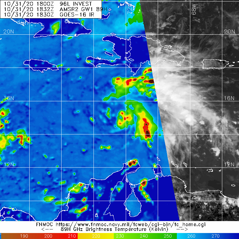
Based on current satellite trends, this could be nearing hurricane status by tomorrow night, well ahead of virtually all models except the HWRF. We still need a centre.
Last edited by Shell Mound on Sat Oct 31, 2020 3:12 pm, edited 1 time in total.
3 likes
CVW / MiamiensisWx / Shell Mound
The posts in this forum are NOT official forecasts and should not be used as such. They are just the opinion of the poster and may or may not be backed by sound meteorological data. They are NOT endorsed by any professional institution or STORM2K. For official information, please refer to products from the NHC and NWS.
Re: ATL: INVEST 96L - Models
CyclonicFury wrote:ronjon wrote::uarrow: Hmmm....seems quite a few of the EPS ensembles are now showing the northward turn. Stay tuned...
It actually seems like many of them develop a separate system. Kinda like what models showed for Cristobal earlier this year but that never panned out and it remained one entity
The majority are from the same system.

0 likes
-
Shell Mound
- Category 5
- Posts: 2432
- Age: 33
- Joined: Thu Sep 07, 2017 3:39 pm
- Location: St. Petersburg, FL → Scandinavia
Re: ATL: INVEST 96L - Models
NDG wrote:CyclonicFury wrote:ronjon wrote::uarrow: Hmmm....seems quite a few of the EPS ensembles are now showing the northward turn. Stay tuned...
It actually seems like many of them develop a separate system. Kinda like what models showed for Cristobal earlier this year but that never panned out and it remained one entity
The majority are from the same system.
https://i.imgur.com/BiA95OA.gif
The members that do show the northward turn nearly stall the system either at or just after landfall. Overall trends favour a loop along the coast, not far inland.
0 likes
CVW / MiamiensisWx / Shell Mound
The posts in this forum are NOT official forecasts and should not be used as such. They are just the opinion of the poster and may or may not be backed by sound meteorological data. They are NOT endorsed by any professional institution or STORM2K. For official information, please refer to products from the NHC and NWS.
-
Blown Away

- S2K Supporter
- Posts: 10253
- Joined: Wed May 26, 2004 6:17 am
Re: ATL: INVEST 96L - Models
NDG wrote:https://i.imgur.com/yK7hboq.png
Is there any storm that moved NE from NW Caribbean over Cuba then back NW over Florida or CONUS??
0 likes
Hurricane Eye Experience: David 79, Irene 99, Frances 04, Jeanne 04, Wilma 05… Hurricane Brush Experience: Andrew 92, Erin 95, Floyd 99, Matthew 16, Irma 17, Ian 22, Nicole 22…
Re: ATL: INVEST 96L - Models
ronjon wrote::uarrow: Hmmm....seems quite a few of the EPS ensembles are now showing the northward turn. Stay tuned...
Before anyone suggests otherwise, the 12Z EPS did not at all trend away from the strong majority of members moving WSW and either dying deep inside CA or coming out into the E Pac as a weak low. So, there is zero trend away from that potential scenario among the 12Z model consensus.
0 likes
Personal Forecast Disclaimer:
The posts in this forum are NOT official forecasts and should not be used as such. They are just the opinion of the poster and may or may not be backed by sound meteorological data. They are NOT endorsed by any professional institution or storm2k.org. For official information, please refer to the NHC and NWS products.
The posts in this forum are NOT official forecasts and should not be used as such. They are just the opinion of the poster and may or may not be backed by sound meteorological data. They are NOT endorsed by any professional institution or storm2k.org. For official information, please refer to the NHC and NWS products.


Re: ATL: TWENTY-NINE - Models
The models have spoken will see at 5pm what TD 29 and its initial track guidance is from the NHC.
0 likes
-
Shell Mound
- Category 5
- Posts: 2432
- Age: 33
- Joined: Thu Sep 07, 2017 3:39 pm
- Location: St. Petersburg, FL → Scandinavia
ATL: TWENTY-NINE - Tropical Depression - Discussion
Loveweather12 wrote:Shell Mound wrote:
You know it’s 2020 when ASCAT fails to detect a budding hurricane and the EPS caves to the GEFS in the short to medium term...as we are witnessing.
EPS caving?
WhAts going on? Didn’t see the latest model?

0 likes
CVW / MiamiensisWx / Shell Mound
The posts in this forum are NOT official forecasts and should not be used as such. They are just the opinion of the poster and may or may not be backed by sound meteorological data. They are NOT endorsed by any professional institution or STORM2K. For official information, please refer to products from the NHC and NWS.
-
GeneratorPower

- S2K Supporter
- Posts: 1648
- Age: 46
- Joined: Sun Dec 18, 2005 11:48 pm
- Location: Huntsville, AL
Re: ATL: INVEST 96L - Discussion
fox13weather wrote:Shell Mound wrote:wxman57 wrote:The requirements for a PTC advisory are that there is a high chance of development (check) AND that the potential storm is within 48 hrs of impacting a coastal region that the NHC warns for (nope). Looks like it will reach the coast of Nicaragua Tuesday evening. Therefore, about the earliest we could expect a PTC advisory would be tomorrow late afternoon. However, if you're curious what the NHC track would look like, it would look just like the consensus model (TVCN):
http://wxman57.com/images/TVCN.JPG
Note that the TVCN indicates a significant slowdown just before landfall. 96L may well loop along the coast of Central America and not move far inland at all.
The current rate of intensification means that 96L (Eta) is less likely to move well inland before stalling, looping offshore, and eventually heading northward.
I’m already thinking this could well become a high-end Cat-4 or even low-end Cat-5 before hitting Cabo Gracias a Dios, stalling, and then entering the GoH.*
*Gulf of Honduras
(At any rate, this won’t weaken much, if at all, due to the brevity of its landfall on the relatively flat, marshy Miskito Coast, near the Nicaragua–Honduras line.)
Don’t be shocked if both Central America and Cuba/Florida face the possibility of multiple Cat-4+ landfalls in association with 96L (future Eta).
"Don’t be shocked if both Central America and Cuba/Florida face the possibility of multiple Cat-4+ landfalls in association with 96L (future Eta)"
Ya, I suppose. At this point, multiple outcomes are possible and what you are speculating is a worst case scenario that includes many moving pieces coming together perfectly. Could it happen? I guess. There are also many other plausible outcomes, but as is usually the case here...lets wishcast the worst possible scenario....
(At any rate, this won’t weaken much, if at all, due to the brevity of its landfall on the relatively flat, marshy Miskito Coast, near the Nicaragua–Honduras line.)
How do you know? You are sure at this point that it will end up along the Nicaragua-Honduras line even though the first advisory has not been issued yet?
I actually enjoy hearing the full range of possible outcomes. Even if some are highly unlikely.
4 likes
Who is online
Users browsing this forum: No registered users and 67 guests