ATL: HANNA - Models
Moderator: S2k Moderators
-
HurricaneBrain

- S2K Supporter

- Posts: 520
- Joined: Thu Jun 30, 2011 2:07 pm
Re: ATL: INVEST 91L - Models
TVCN with a Freeport landfall. Agreed recon needs to fly into this today regardless of improvement of structure. Need data inserted into the globals.
0 likes

Re: ATL: INVEST 91L - Models
The Euro wants to bring some really heavy rains into the Corpus Christi area now, up to 12". Yesterday, it was focused mor on San Antonio.

1 likes
Personal Forecast Disclaimer:
The posts in this forum are NOT official forecast and should not be used as such. They are just the opinion of the poster and may or may not be backed by sound meteorological data. They are NOT endorsed by any professional institution or storm2k.org. For official information, please refer to the NHC and NWS products.
The posts in this forum are NOT official forecast and should not be used as such. They are just the opinion of the poster and may or may not be backed by sound meteorological data. They are NOT endorsed by any professional institution or storm2k.org. For official information, please refer to the NHC and NWS products.

Re: ATL: INVEST 91L - Models
Here's some updated 12z stuff from the mesoscale models
12Z HRRR @ 36 hours / Tomorrow night at 7pm

12Z 3km NAM @ 48 hours / 7am Friday

12Z HRRR @ 36 hours / Tomorrow night at 7pm
12Z 3km NAM @ 48 hours / 7am Friday
4 likes
Re: ATL: INVEST 91L - Models
ICON is in and it stalls it around the coast of Texas hence a couple spots in South Texas over 12" of rain. We'll see if the GFS catches up or insists no more than a half inch or so.

1 likes
Re: ATL: INVEST 91L - Models
GFS through 66 hours doesn't even have any 2" amounts onshore. Still not buying this.

1 likes
Re: ATL: INVEST 91L - Models
Canadian is more similar to the ICON, NAM and EC than the GFS. This is through 120 hours / 7pm Sunday.

4 likes
-
gatorcane

- S2K Supporter
- Posts: 23708
- Age: 48
- Joined: Sun Mar 13, 2005 3:54 pm
- Location: Boca Raton, FL
Re: ATL: INVEST 91L - Models
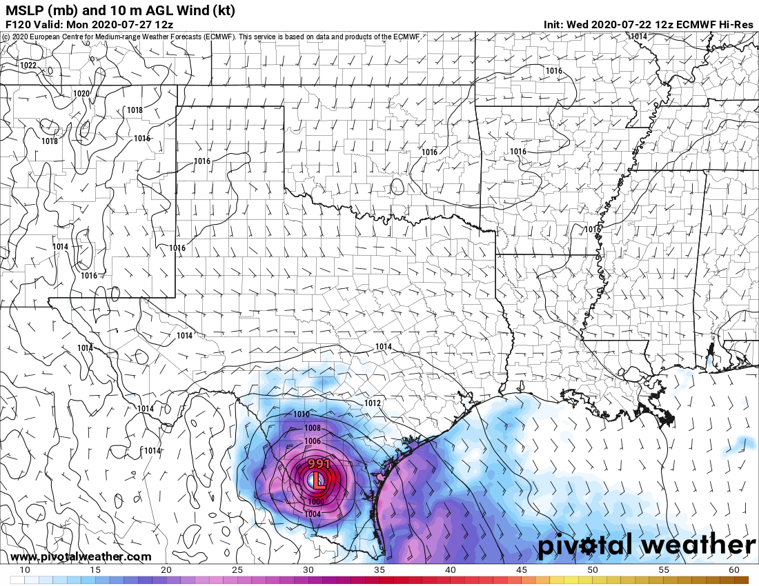
The 12Z Euro actually strengthens this close to landfall and then over land. That is a sign this could become something as the last minute as it makes landfall.
1 likes
-
supercane4867
- Category 5

- Posts: 4966
- Joined: Wed Nov 14, 2012 10:43 am
Re: ATL: INVEST 91L - Models
Euro is drunk. 1003mb -> 991mb over land.
Last edited by supercane4867 on Wed Jul 22, 2020 1:27 pm, edited 2 times in total.
4 likes
-
HurricaneFrances04
- Category 2

- Posts: 597
- Joined: Mon Jun 25, 2012 8:09 am
- Location: Fort Lauderdale, Florida


Re: ATL: INVEST 91L - Models
Nice to see Euro jumping on board as model support rapidly increases, GFS is the only holdout now.
1 likes
The above post is not official and should not be used as such. It is the opinion of the poster and may or may not be backed by sound meteorological data. It is not endorsed by any professional institution or storm2k.org. For official information, please refer to the NHC and NWS products.
-
Stormcenter
- S2K Supporter
- Posts: 6689
- Joined: Wed Sep 03, 2003 11:27 am
- Location: Houston, TX
Re: ATL: INVEST 91L - Models
Is it April Fools Day? I mean really, the EURO
is in la la land with strengthening over land thing.
is in la la land with strengthening over land thing.
0 likes
-
Portastorm

- Storm2k Moderator

- Posts: 9954
- Age: 63
- Joined: Fri Jul 11, 2003 9:16 am
- Location: Round Rock, TX
- Contact:
Re: ATL: INVEST 91L - Models
As Houston-area met Matt Lanza just pointed out on Twitter, the conditions necessary for a "Brown Ocean" effect will not be in play in South Texas. That makes the Euro scenario even more improbable.
2 likes
Any forecasts under my name are to be taken with a grain of salt. Get your best forecasts from the National Weather Service and National Hurricane Center.
Re: ATL: INVEST 91L - Models
The EURO's rainfall forecast is not good for the Corpus Christi area.

3 likes
Personal Forecast Disclaimer:
The posts in this forum are NOT official forecast and should not be used as such. They are just the opinion of the poster and may or may not be backed by sound meteorological data. They are NOT endorsed by any professional institution or storm2k.org. For official information, please refer to the NHC and NWS products.
The posts in this forum are NOT official forecast and should not be used as such. They are just the opinion of the poster and may or may not be backed by sound meteorological data. They are NOT endorsed by any professional institution or storm2k.org. For official information, please refer to the NHC and NWS products.
Re: ATL: INVEST 91L - Models
LOL. Usually systems deepen overland when moving north and undergoing baroclinic processes. However, I wouldn't discount the idea of a better environment slightly inland and moving west of suppression. I don't think it would drop 10mb, more like 1-2. HRRR 18z is running, and I'll have that up in a few minutes.
2 likes
-
jaguars_22
- Category 2
- Posts: 629
- Joined: Tue Jun 20, 2017 2:26 pm
- Location: Victoria TX
Re: ATL: INVEST 91L - Models
HRRR slows down the forward motion once it nears the coast or so it seems... I guess recon isnt flying today
1 likes
Re: ATL: INVEST 91L - Models
Yeah, that's been a theme with some of the models showing a slow crawl west near to or at the coast. Here's HRRR valid 1am Friday

0 likes
Re: ATL: INVEST 91L - Models
Stormcenter wrote:Is it April Fools Day? I mean really, the EURO
is in la la land with strengthening over land thing.
It does that often for some reason.
0 likes
The above post is not official and should not be used as such. It is the opinion of the poster and may or may not be backed by sound meteorological data. It is not endorsed by any professional institution or storm2k.org. For official information, please refer to the NHC and NWS products.

Re: ATL: INVEST 91L - Models
Hammy wrote:Stormcenter wrote:Is it April Fools Day? I mean really, the EURO
is in la la land with strengthening over land thing.
It does that often for some reason.
I agree! I’ve seen the Euro do that many times. Not sure why it does that?
0 likes
Re: ATL: INVEST 91L - Models
NAM 3km @ 27 hours / 4pm tomorrow

I'm thinking it might have it over-organized, though Thursday seemed like the day we'd get the most change (upgrade) in organization
I'm thinking it might have it over-organized, though Thursday seemed like the day we'd get the most change (upgrade) in organization
3 likes
-
TheProfessor

- Professional-Met

- Posts: 3506
- Age: 29
- Joined: Tue Dec 03, 2013 10:56 am
- Location: Wichita, Kansas
Re: ATL: INVEST 91L - Models
I'm not sure how well the Parallel GFS is verifying and this run is 24 hours old(but the latest), but it's showing the potential for a strong feeder band east of the storm around the Louisiana and Mississippi border. Could be interesting to see if any other models picks up on that.

2 likes
An alumnus of The Ohio State University.
Your local National Weather Service office is your best source for weather information.
Your local National Weather Service office is your best source for weather information.
Who is online
Users browsing this forum: No registered users and 25 guests