https://twitter.com/pppapin/status/1292529441105678336
ATL: JOSEPHINE - Remnants - Discussion
Moderator: S2k Moderators
-
cycloneye

- Admin

- Posts: 149214
- Age: 69
- Joined: Thu Oct 10, 2002 10:54 am
- Location: San Juan, Puerto Rico
Re: ATL: INVEST 95L - Discussion
0 likes
Visit the Caribbean-Central America Weather Thread where you can find at first post web cams,radars
and observations from Caribbean basin members Click Here
and observations from Caribbean basin members Click Here
-
gatorcane

- S2K Supporter

- Posts: 23708
- Age: 48
- Joined: Sun Mar 13, 2005 3:54 pm
- Location: Boca Raton, FL
Re: ATL: INVEST 95L - Discussion
0 likes
-
ConvergenceZone
.gif)
- Category 5

- Posts: 5241
- Joined: Fri Jul 29, 2005 1:40 am
- Location: Northern California
Re: ATL: INVEST 95L - Discussion
Is all this dry air in almost mid August normal?? Or does the excessive dry air not dissipate until September. Folks were saying before to wait until mid August for the excessive dry air to abate, but mid August is only 6 days away, unless I misunderstood and am missing something?
0 likes

Re: ATL: INVEST 95L - Discussion
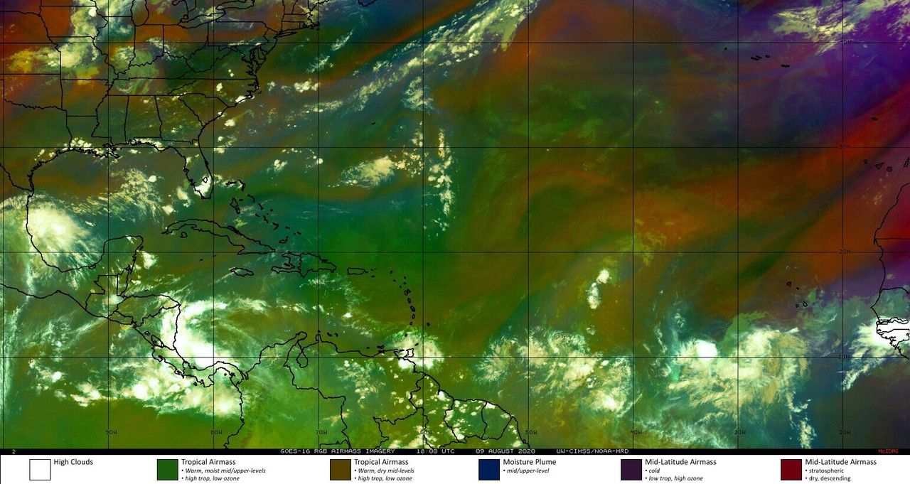
Here is the real IR Satellite Analysis and latest ASCAT.
Sorry about the mix up earlier
Still the same comment though, looks close to being a TD.


Sorry about the mix up earlier
Still the same comment though, looks close to being a TD.
6 likes
-
EquusStorm
- Category 5
- Posts: 1649
- Age: 35
- Joined: Thu Nov 07, 2013 1:04 pm
- Location: Jasper, AL
- Contact:
Re: ATL: INVEST 95L - Discussion
Do I have to keep posting the link to the major SAL outbreaks of mid August 2017 that kept coming over and over until a few days before Irma
10 likes
Colors of lost purpose on the canvas of irrelevance
Not a meteorologist, in fact more of an idiot than anything. You should probably check with the NHC or a local NWS office for official information.
Not a meteorologist, in fact more of an idiot than anything. You should probably check with the NHC or a local NWS office for official information.


Re: ATL: INVEST 95L - Discussion
EquusStorm wrote:Do I have to keep posting the link to the major SAL outbreaks of mid August 2017 that kept coming over and over until a few days before Irma
There have even been fairly active Augusts that have still had a large amount of dry air
0 likes
-
ConvergenceZone
- Category 5
- Posts: 5241
- Joined: Fri Jul 29, 2005 1:40 am
- Location: Northern California
Re: ATL: INVEST 95L - Discussion
tiger_deF wrote:EquusStorm wrote:Do I have to keep posting the link to the major SAL outbreaks of mid August 2017 that kept coming over and over until a few days before Irma
There have even been fairly active Augusts that have still had a large amount of dry air
Then maybe the models should be updated then, because they don’t seem to point to development due to all the dry air. Perhaps they should be updated?
0 likes
-
cycloneye
- Admin
- Posts: 149214
- Age: 69
- Joined: Thu Oct 10, 2002 10:54 am
- Location: San Juan, Puerto Rico
Re: ATL: INVEST 95L - Discussion
18z Best Track:
AL, 95, 2020080918, , BEST, 0, 106N, 280W, 25, 1009, DB, 34, NEQ, 0, 0, 0, 0, 1013, 180, 50, 0, 0, L, 0, , 0, 0, INVEST, S
At 1800 UTC, 09 August 2020, DISTURBANCE INVEST 95 (AL95) was located in the North Atlantic basin at 10.6°N and 28°W. The current intensity was 25 kt and the center was moving at 17 kt at a bearing of 275 degrees. The minimum central pressure was 1009 mb.
2 likes
Visit the Caribbean-Central America Weather Thread where you can find at first post web cams,radars
and observations from Caribbean basin members Click Here
and observations from Caribbean basin members Click Here
-
USTropics
- Professional-Met

- Posts: 2736
- Joined: Sun Aug 12, 2007 3:45 am
- Location: Florida State University
Re: ATL: INVEST 95L - Discussion
ConvergenceZone wrote:Is all this dry air in almost mid August normal?? Or does the excessive dry air not dissipate until September. Folks were saying before to wait until mid August for the excessive dry air to abate, but mid August is only 6 days away, unless I misunderstood and am missing something?
Some more experimental products I've been working on. Here are relative humidity (RH) anomaly values (in %) for July 24th - August 7th 2020 (500mb is upper-level, 700mb is mid-level). RH values in the MDR are actually slightly higher than climo, but the Caribbean has been slightly lower. Not seeing any major anomalous mid or upper level dry air compared to climo. Remember also that suppressed phases of MJO/CCKW promote increased SAL/dry air (i.e. changes in wind flow increase advection of substance into mid-upper level flow over Atlantic).


Edit: fixed 500mb image (double posted 700mb)
Last edited by USTropics on Sun Aug 09, 2020 3:20 pm, edited 1 time in total.
15 likes
Re: ATL: INVEST 95L - Discussion
EquusStorm wrote:Do I have to keep posting the link to the major SAL outbreaks of mid August 2017 that kept coming over and over until a few days before Irma
I've seen this posted several times but some just don't get it
1 likes

Re: ATL: INVEST 95L - Discussion
USTropics wrote:ConvergenceZone wrote:Is all this dry air in almost mid August normal?? Or does the excessive dry air not dissipate until September. Folks were saying before to wait until mid August for the excessive dry air to abate, but mid August is only 6 days away, unless I misunderstood and am missing something?
Some more experimental products I've been working on. Here are relative humidity (RH) anomaly values (in %) for July 24th - August 7th 2020 (500mb is upper-level, 700mb is mid-level). RH values in the MDR are actually slightly higher than climo, but the Caribbean has been slightly lower. Not seeing any major anomalous mid or upper level dry air compared to climo. Remember also that suppressed phases of MJO/CCKW promote increased SAL/dry air (i.e. changes in wind flow increase advection of substance into mid-upper level flow over Atlantic).
https://i.imgur.com/SJJDbfj.png
https://i.imgur.com/7JcqZLA.png
Edit: fixed 500mb image (double posted 700mb)
Precipitable water anomalies have also increased substantially during this time frame (7/24 - 8/07), which correlates with the overall increase in RH over the past two weeks.

4 likes
-
Kingarabian

- S2K Supporter
- Posts: 16342
- Joined: Sat Aug 08, 2009 3:06 am
- Location: Honolulu, Hawaii
Re: ATL: INVEST 95L - Discussion
Pretty solid. This is what active seasons do. Regardless of the intra-seasonal signal, they still are capable of development.
12 likes
RIP Kobe Bryant

Re: ATL: INVEST 95L - Discussion

5 likes
Andrew (1992), Irene (1999), Frances (2004), Katrina (2005), Wilma (2005), Fay (2008), Irma (2017), Eta (2020), Ian (2022)
Re: ATL: INVEST 95L - Discussion
As long as we keep these storms away from southern New England until it cools down I'll be happy.. just lost power for two days and cant stand the heat and lost all my food in the fridge.. many places are still without power around here
3 likes
-
cycloneye
- Admin
- Posts: 149214
- Age: 69
- Joined: Thu Oct 10, 2002 10:54 am
- Location: San Juan, Puerto Rico
Re: ATL: INVEST 95L - Discussion
Tropical Weather Outlook
NWS National Hurricane Center Miami FL
800 PM EDT Sun Aug 9 2020
For the North Atlantic...Caribbean Sea and the Gulf of Mexico:
Showers and thunderstorms associated with a tropical wave located a
few hundred miles south-southwest of the Cabo Verde Islands continue
to show signs of organization. However, recent satellite-derived
wind data indicates that the circulation remains elongated.
Environmental conditions appear conducive enough to support
additional development of this system, and a tropical depression
could form during the next few days while it moves generally
westward at 15 mph across the tropical Atlantic. Conditions are
likely to become less conducive for development late this week.
* Formation chance through 48 hours...medium...40 percent.
* Formation chance through 5 days...medium...50 percent.
$$
Forecaster Pasch
2 likes
Visit the Caribbean-Central America Weather Thread where you can find at first post web cams,radars
and observations from Caribbean basin members Click Here
and observations from Caribbean basin members Click Here

Re: ATL: INVEST 95L - Discussion
cycloneye wrote:Tropical Weather Outlook
NWS National Hurricane Center Miami FL
800 PM EDT Sun Aug 9 2020
For the North Atlantic...Caribbean Sea and the Gulf of Mexico:
Showers and thunderstorms associated with a tropical wave located a
few hundred miles south-southwest of the Cabo Verde Islands continue
to show signs of organization. However, recent satellite-derived
wind data indicates that the circulation remains elongated.
Environmental conditions appear conducive enough to support
additional development of this system, and a tropical depression
could form during the next few days while it moves generally
westward at 15 mph across the tropical Atlantic. Conditions are
likely to become less conducive for development late this week.
* Formation chance through 48 hours...medium...40 percent.
* Formation chance through 5 days...medium...50 percent.
$$
Forecaster Pasch

Seems more SW of the Cabo Verde Islands than SSW.
1 likes
-
MGC

- S2K Supporter
- Posts: 5940
- Joined: Sun Mar 23, 2003 9:05 pm
- Location: Pass Christian MS, or what is left.
Re: ATL: INVEST 95L - Discussion
Lots of tropical storms form during a negative MJO so don't dismiss 95L. After reviewing the WV at the mid and upper levels I think the disturbance is in a moist enough environment to further develop. 95L has some decent spin so lets sit back and see what happens.......MGC
5 likes
-
eastcoastFL

- Category 5
- Posts: 3996
- Age: 44
- Joined: Thu Apr 12, 2007 12:29 pm
- Location: Palm City, FL
Re: ATL: INVEST 95L - Discussion

Models seem to at least be in some agreement on track for the next few days. Then they split between fish or no fish.
2 likes
Personal Forecast Disclaimer:
The posts in this forum are NOT official forecast and should not be used as such. They are just the opinion of the poster and may or may not be backed by sound meteorological data. They are NOT endorsed by any professional institution or storm2k.org. For official information, please refer to the NHC and NWS products.
The posts in this forum are NOT official forecast and should not be used as such. They are just the opinion of the poster and may or may not be backed by sound meteorological data. They are NOT endorsed by any professional institution or storm2k.org. For official information, please refer to the NHC and NWS products.
-
cainjamin

- Tropical Storm

- Posts: 173
- Age: 34
- Joined: Mon Apr 17, 2017 1:38 pm
- Location: Nova Scotia, Canada
Re: ATL: INVEST 95L - Discussion
Sustaining some pretty decent convection over the centre tonight.
3 likes
Noel '07, Kyle '08, Earl '10, Arthur '14, Dorian '19, Teddy '20, Lee '23
Re: ATL: INVEST 95L - Discussion
cainjamin wrote:Sustaining some pretty decent convection over the center tonight.
Yep. I was just about to post about that. Formation chances will probably be increased in the next TWO. Perhaps 50/60.
0 likes
Who is online
Users browsing this forum: No registered users and 25 guests