
WPAC: BAVI - Post-Tropical
Moderator: S2k Moderators
-
doomhaMwx

- Category 5

- Posts: 2487
- Age: 27
- Joined: Tue Apr 18, 2017 4:01 am
- Location: Baguio/Benguet, Philippines
- Contact:
Re: WPAC: BAVI - Tropical Storm
Low level center displaced west of the MLC, but the system appears to be becoming vertically stacked now.
0 likes
-
euro6208
Re: WPAC: BAVI - Tropical Storm
Favorable environment ahead.
WDPN31 PGTW 220300
MSGID/GENADMIN/JOINT TYPHOON WRNCEN PEARL HARBOR HI//
SUBJ/PROGNOSTIC REASONING FOR TROPICAL STORM 09W (BAVI) WARNING NR
003//
RMKS/
1. FOR METEOROLOGISTS.
2. 6 HOUR SUMMARY AND ANALYSIS.
TROPICAL STORM (TS) 09W (BAVI), LOCATED APPROXIMATELY 331 NM WEST-
SOUTHWEST OF KADENA AB, OKINAWA, HAS TRACKED NORTH-NORTHEASTWARD AT
06 KNOTS (KTS) OVER THE PAST SIX HOURS. ANIMATED MULTISPECTRAL
IMAGERY AND ANIMATED RADAR IMAGERY REVEAL A PARTIALLY-EXPOSED LOW
LEVEL CIRCULATION CENTER (LLCC) WITH DEEP CONVECTION OVER THE
EASTERN SEMICIRCLE OF THE SYSTEM. A 212313Z SSMIS 89 GHZ PARTIAL
MICROWAVE IMAGE SHOWS SHALLOW BANDING WRAPPING INTO THE CENTER FROM
THE WEST AND CONFIRMS THE DEEP CONVECTION TO THE SOUTH AND EAST. SET
AT 35 KTS, THE INITIAL INTENSITY IS BASED ON A SATELLITE CONSENSUS
ESTIMATE OF 34 KTS AND MULTI-AGENCY DVORAK CURRENT INTENSITY
ESTIMATES OF T1.5-T2.0 (25-30 KTS) BY PGTW, RJTD, AND KNES.
FURTHERMORE, A 220055Z PARTIAL ASCAT-B IMAGE DEPICTS A SWATH OF 35-
39 KT WINDS SURROUNDED BY 30-34 KT WINDS IN THE EASTERN QUADRANT,
PLACING GOOD CONFIDENCE IN THE INITIAL INTENSITY. TS 09W REMAINS IN
A HIGHLY FAVORABLE ENVIRONMENT CHARACTERIZED BY LOW (10-15 KTS)
VERTICAL WIND SHEAR, WARM (29-30 CELSIUS) SEA SURFACE TEMPERATURES,
AND HIGH OCEAN HEAT CONTENT VALUES. ADDITIONALLY, THE SYSTEM IS
SUPPORTED BY EXCELLENT EQUATORWARD OUTFLOW AND DEVELOPING POLEWARD
OUTFLOW WHICH IS BEING ENHANCED BY AN UPPER LOW TO THE NORTHEAST. A
SUBTROPICAL RIDGE (STR) TO THE EAST WITH A SLIGHT WEAK EXTENSION TO
THE NORTH IS ACTING AS THE PRIMARY STEERING FEATURE. CURRENTLY, TS
09W IS TRACKING NORTH-NORTHWESTWARD ALONG ITS PERIPHERY.
3. FORECAST REASONING.
A. NO CHANGE TO THE FORECAST PHILOSOPHY SINCE THE PREVIOUS
PROGNOSTIC REASONING MESSAGE.
B. AS A PASSING SHORTWAVE TROUGH DIGS OVER THE EAST CHINA SEA,
THE WEAK STR EXTENSION IS EXPECTED TO ERODE WHICH WILL CAUSE THE STR
TO REORIENT. BY TAU 24, TS 09W IS FORECAST TO TURN NORTHEASTWARD AND
TRACK ALONG THE PERIPHERY OF THE REORIENTED STR. THE FAVORABLE
ENVIRONMENT WILL CONTINUE TO INTENSIFY THE SYSTEM THROUGHOUT THIS
PERIOD. AFTER TAU 48, TS 09W IS EXPECTED TO SLOW AS IT TURNS TO
NORTHWARD FOLLOWING TROUGH PASSAGE. THE TROUGH PASSAGE IS EXPECTED
TO ENHANCE POLEWARD OUTFLOW, ALLOWING THE SYSTEM TO INTENSIFY TO 95
KTS BY TAU 72. DYNAMIC MODEL GUIDANCE IS IN FAIR AGREEMENT,
GRADUALLY INCREASING TO A SPREAD OF 150 NM BY TAU 72 AS THE SYSTEM
RECURVES TO THE NORTH.
C. IN THE EXTENDED FORECAST, A STR WILL BUILD OVER WESTERN JAPAN
AFTER THE TROUGH PROPAGATES EASTWARD. AT THIS POINT, TS 09W WILL
TURN NORTHWARD ALONG THE WESTERN PERIPHERY OF THE STR UNTIL LANDFALL
IN SOUTH KOREA AFTER TAU 96. A FAVORABLE ENVIRONMENT WILL ALLOW TS
09W TO INTENSIFY TO A PEAK OF 105 KTS BY TAU 96. AFTERWARDS,
DEGRADING ENVIRONMENTAL CONDITIONS OF INCREASING VERTICAL WIND SHEAR
AND INTERACTION WITH THE KOREAN PENINSULA WILL WEAKEN THE SYSTEM,
FIRST GRADUALLY AND THEN RAPIDLY. A 140 NM SPREAD IN MODELS AT TAU
96 LENDS UNCERTAINTY TO THE LANDFALL LOCATION. HOWEVER, THE
NUMERICAL MODELS ARE IN OVERALL FAIR AGREEMENT, LENDING MODERATE
CONFIDENCE TO THE JTWC FORECAST TRACK.//
NNNN
0 likes

Re: WPAC: BAVI - Tropical Storm
Well, well 

1 likes
ヤンデレ女が寝取られるているのを見たい!!!
ECMWF ensemble NWPAC plots: https://ecmwfensnwpac.imgbb.com/
Multimodel NWPAC plots: https://multimodelnwpac.imgbb.com/
GFS Ensemble NWPAC plots (16 & 35 day forecast): https://gefsnwpac.imgbb.com/
Plots updated automatically
ECMWF ensemble NWPAC plots: https://ecmwfensnwpac.imgbb.com/
Multimodel NWPAC plots: https://multimodelnwpac.imgbb.com/
GFS Ensemble NWPAC plots (16 & 35 day forecast): https://gefsnwpac.imgbb.com/
Plots updated automatically
-
1900hurricane

- Category 5
- Posts: 6063
- Age: 34
- Joined: Fri Feb 06, 2015 12:04 pm
- Location: Houston, TX
- Contact:
Re: WPAC: BAVI - Tropical Storm
Going to be interesting to see how strong it gets in the East China Sea. That's not a historical hotbed for intense typhoons really. Heat potential is pretty high all things considered, but not high enough to sustain it if it gets intense and stalls or just kind of drifts around. It also has to contend with Taiwan in the short term. I think the JTWC forecast is pretty reasonable.

1 likes
Contract Meteorologist. TAMU & MSST. Fiercely authentic, one of a kind. We are all given free will, so choose a life meant to be lived. We are the Masters of our own Stories.
Opinions expressed are mine alone.
Follow me on Twitter at @1900hurricane : Read blogs at https://1900hurricane.wordpress.com/
Opinions expressed are mine alone.
Follow me on Twitter at @1900hurricane : Read blogs at https://1900hurricane.wordpress.com/
-
doomhaMwx
- Category 5
- Posts: 2487
- Age: 27
- Joined: Tue Apr 18, 2017 4:01 am
- Location: Baguio/Benguet, Philippines
- Contact:
Re: WPAC: BAVI - Tropical Storm
0 likes
-
euro6208
Re: WPAC: BAVI - Tropical Storm

Oh wow?
Wasn't expecting this.
Looks like it's rapidly intensifying.
Agencies and dvorak playing catchup now.
0 likes
Re: WPAC: BAVI - Severe Tropical Storm
STS 2008 (Bavi)
Issued at 09:50 UTC, 22 August 2020
<Analysis at 09 UTC, 22 August>
Scale -
Intensity -
Center position N24°55' (24.9°)
E123°50' (123.8°)
Direction and speed of movement NNE 15 km/h (8 kt)
Central pressure 990 hPa
Maximum wind speed near center 30 m/s (55 kt)
Maximum wind gust speed 40 m/s (80 kt)
≥ 50 kt wind area SE 75 km (40 NM)
NW 35 km (20 NM)
≥ 30 kt wind area E 330 km (180 NM)
W 165 km (90 NM)
0 likes
ヤンデレ女が寝取られるているのを見たい!!!
ECMWF ensemble NWPAC plots: https://ecmwfensnwpac.imgbb.com/
Multimodel NWPAC plots: https://multimodelnwpac.imgbb.com/
GFS Ensemble NWPAC plots (16 & 35 day forecast): https://gefsnwpac.imgbb.com/
Plots updated automatically
ECMWF ensemble NWPAC plots: https://ecmwfensnwpac.imgbb.com/
Multimodel NWPAC plots: https://multimodelnwpac.imgbb.com/
GFS Ensemble NWPAC plots (16 & 35 day forecast): https://gefsnwpac.imgbb.com/
Plots updated automatically
-
mrbagyo

- Category 5
- Posts: 3963
- Age: 33
- Joined: Thu Apr 12, 2012 9:18 am
- Location: 14.13N 120.98E
- Contact:
Re: WPAC: BAVI - Severe Tropical Storm

0 likes
The posts in this forum are NOT official forecast and should not be used as such. They are just the opinion of the poster and may or may not be backed by sound meteorological data. They are NOT endorsed by any professional institution or storm2k.org. For official information, please refer to RSMC, NHC and NWS products.
Re: WPAC: BAVI - Severe Tropical Storm
0 likes
Personal Forecast Disclaimer:
The posts in this forum are NOT official forecast and should not be used as such. They are just the opinion of the poster and may or may not be backed by sound meteorological data. They are NOT endorsed by any professional institution or storm2k.org. For official information, please refer to RSMC and NWS products.
The posts in this forum are NOT official forecast and should not be used as such. They are just the opinion of the poster and may or may not be backed by sound meteorological data. They are NOT endorsed by any professional institution or storm2k.org. For official information, please refer to RSMC and NWS products.
-
euro6208
Re: WPAC: BAVI - Severe Tropical Storm
Up to 50 knots. Rapid intensification likely.
WDPN31 PGTW 221500
MSGID/GENADMIN/JOINT TYPHOON WRNCEN PEARL HARBOR HI//
SUBJ/PROGNOSTIC REASONING FOR TROPICAL STORM 09W (BAVI) WARNING NR
005//
RMKS/
1. FOR METEOROLOGISTS.
2. 6 HOUR SUMMARY AND ANALYSIS.
TROPICAL STORM (TS) 09W (BAVI), LOCATED APPROXIMATELY 228 NM WEST-
SOUTHWEST OF KADENA AB, OKINAWA, HAS TRACKED NORTH-NORTHEASTWARD AT
11 KNOTS (KTS) OVER THE PAST SIX HOURS. ANIMATED ENHANCED INFRARED
(EIR) SATELLITE IMAGERY DEPICTS A COMPACT SYSTEM WITH FLARING
CONVECTION WRAPPING INTO A PARTIALLY EXPOSED LOW LEVEL CIRCULATION
CENTER. THE CONVECTION HAS WEAKENED SLIGHTLY OVER THE PAST 6 HOURS
BUT IS BEGINNING TO FLARE AND BUILD OVER THE SOUTHERN
PORTION OF THE SEMICIRCLE. THE INITIAL POSITION IS PLACED WITH HIGH
CONFIDENCE BASED ON THE LOW LEVEL CIRCULATION FEATURES PRESENT IN THE
EIR AND COMPOSITE RADAR LOOPS. THE INITIAL INTENSITY IS ALSO PLACED
WITH HIGH CONFIDENCE AND IS HEDGED ABOVE MULTIAGENCY DVORAK CURRENT
INTENSITY ESTIMATES OF T2.5 (PGTW AND RCTP, 35 KTS) AND T3.0 (RJTD,
45 KTS) DUE TO THE PRESENCE OF 45-50 KTS WINDS PRESENT IN TIMELY DATA
FROM A 221235Z ASCAT-A PASS. THE SYSTEM IS TRACKING GENERALLY NORTH-
NORTHEASTWARD ALONG AN EXTENSION OF A SUBTROPICAL RIDGE (STR)
POSITIONED TO THE SOUTHEAST AND THROUGH AN ENVIRONMENT FAVORABLE
FOR INTENSIFICATION WITH VERY WARM (30-31 CELSIUS) SEA SURFACE
TEMPERATURES, LOW (10-15 KTS) VERTICAL WIND SHEAR AND WELL ESTABLISHED EQUATORWARD OUTFLOW IN THE UPPER LEVELS.
3. FORECAST REASONING.
A. NO CHANGE TO THE FORECAST PHILOSOPHY SINCE THE PREVIOUS
PROGNOSTIC REASONING MESSAGE.
B. TS BAVI WILL CONTINUE TO TRACK GENERALLY NORTHEASTWARD AS IT
ROUNDS THE STR POSITIONED TO THE SOUTHEAST. AN UPPER LEVEL TROUGH
PASSING TO THE NORTH IS EXPECTED TO INTERACT WITH THE SYSTEM THROUGH
THE NEXT 24 HOURS AND ENHANCE THE UPPER LEVEL POLEWARD OUTFLOW. THIS
ENHANCED OUTFLOW, ALONG WITH CONTINUED LOW VERTICAL WIND SHEAR AND VERY WARM SSTS WILL ALLOW FOR FURTHER, AND POSSIBLY RAPID, INTENSIFICATION TO 75 KTS BY TAU 24 AND TO 85 KTS BY TAU 36. DURING THIS TIME, THE SHORTWAVE TROUGH WILL INDUCE A REORIENTATION AND EROSION OF THE STEERING STR. AS A RESULT, TS BAVI WILL SLOW AND BEGIN TRACKING NORTHWARD ALONG THE WESTERN PERIPHERY OF A STR POSITIONED TO THE EAST STARTING AT TAU 48. CONTINUED WARM SSTS AND MODERATE (20-25 KTS) VWS WILL LEAD TO FURTHER INTENSIFICATION DURING THIS NORTHWARD TRACK AND ALLOW THE SYSTEM TO REACH A MAXIMUM INTENSITY OF 105 KTS BY TAU 72. THERE IS A FAIR DEGREE OF UNCERTAINTY IN MODEL SOLUTIONS DURING THIS PERIOD DUE TO THE TIMING OF THE SHORTWAVE TROUGH MOVEMENT, WITH A 124 NM SPREAD IN ACROSS TRACK SOLUTIONS BY TAU 48. THIS SPREAD IN SOLUTIONS LENDS ONLY FAIR CONFIDENCE
TO THE INITIAL PORTION (TAU 0-72) OF THE JTWC FORECAST TRACK.
NNNN
0 likes
-
1900hurricane
- Category 5
- Posts: 6063
- Age: 34
- Joined: Fri Feb 06, 2015 12:04 pm
- Location: Houston, TX
- Contact:
Re: WPAC: BAVI - Severe Tropical Storm
Taiwan doing its thing.

0 likes
Contract Meteorologist. TAMU & MSST. Fiercely authentic, one of a kind. We are all given free will, so choose a life meant to be lived. We are the Masters of our own Stories.
Opinions expressed are mine alone.
Follow me on Twitter at @1900hurricane : Read blogs at https://1900hurricane.wordpress.com/
Opinions expressed are mine alone.
Follow me on Twitter at @1900hurricane : Read blogs at https://1900hurricane.wordpress.com/
-
gatorcane

- S2K Supporter

- Posts: 23708
- Age: 48
- Joined: Sun Mar 13, 2005 3:54 pm
- Location: Boca Raton, FL
Re: WPAC: BAVI - Severe Tropical Storm
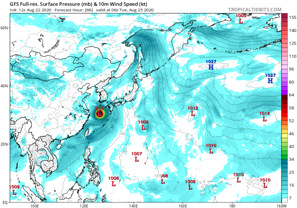
12Z GFS down to 945MB:
Saved loop, looking like it is wrapping up:
http://rammb.cira.colostate.edu/ramsdis ... display=24
Saved loop, looking like it is wrapping up:
http://rammb.cira.colostate.edu/ramsdis ... display=24
0 likes
-
1900hurricane
- Category 5
- Posts: 6063
- Age: 34
- Joined: Fri Feb 06, 2015 12:04 pm
- Location: Houston, TX
- Contact:
Re: WPAC: BAVI - Severe Tropical Storm
Bavi is going to have to gain some distance from Taiwan to intensify. It already has a large circulation, and intensification is only going to increase the airflow demands in the circulation. Dry downsloping air off the high mountains has already impacted Bavi as it tried to intensify the first time.
0 likes
Contract Meteorologist. TAMU & MSST. Fiercely authentic, one of a kind. We are all given free will, so choose a life meant to be lived. We are the Masters of our own Stories.
Opinions expressed are mine alone.
Follow me on Twitter at @1900hurricane : Read blogs at https://1900hurricane.wordpress.com/
Opinions expressed are mine alone.
Follow me on Twitter at @1900hurricane : Read blogs at https://1900hurricane.wordpress.com/
-
euro6208
Re: WPAC: BAVI - Severe Tropical Storm
TPPN10 PGTW 230027
A. TROPICAL STORM 09W (BAVI)
B. 23/0000Z
C. 26.22N
D. 123.81E
E. FIVE/HMWRI8
F. T3.5/3.5/D1.5/24HRS STT: D0.5/03HRS
G. IR/EIR/VIS/MSI
H. REMARKS: 40A/PBO SBC/ANMTN. CNVCTN WRAPS .60 ON LOG10 SPIRAL
YIELDING A DT OF 3.0. MET AND PT YIELD 3.5. DBO PT.
I. ADDITIONAL POSITIONS: NONE
HEINS
A. TROPICAL STORM 09W (BAVI)
B. 23/0000Z
C. 26.22N
D. 123.81E
E. FIVE/HMWRI8
F. T3.5/3.5/D1.5/24HRS STT: D0.5/03HRS
G. IR/EIR/VIS/MSI
H. REMARKS: 40A/PBO SBC/ANMTN. CNVCTN WRAPS .60 ON LOG10 SPIRAL
YIELDING A DT OF 3.0. MET AND PT YIELD 3.5. DBO PT.
I. ADDITIONAL POSITIONS: NONE
HEINS
0 likes
-
storminabox
- Category 1

- Posts: 263
- Joined: Sun Jul 09, 2017 10:50 pm
Re: WPAC: BAVI - Severe Tropical Storm
Will this be the first intense typhoon of the season?
0 likes
-
1900hurricane
- Category 5
- Posts: 6063
- Age: 34
- Joined: Fri Feb 06, 2015 12:04 pm
- Location: Houston, TX
- Contact:
Re: WPAC: BAVI - Severe Tropical Storm
Looking a lot better with convection refiring around the center. Would love a good SMAP pass about now.

0 likes
Contract Meteorologist. TAMU & MSST. Fiercely authentic, one of a kind. We are all given free will, so choose a life meant to be lived. We are the Masters of our own Stories.
Opinions expressed are mine alone.
Follow me on Twitter at @1900hurricane : Read blogs at https://1900hurricane.wordpress.com/
Opinions expressed are mine alone.
Follow me on Twitter at @1900hurricane : Read blogs at https://1900hurricane.wordpress.com/
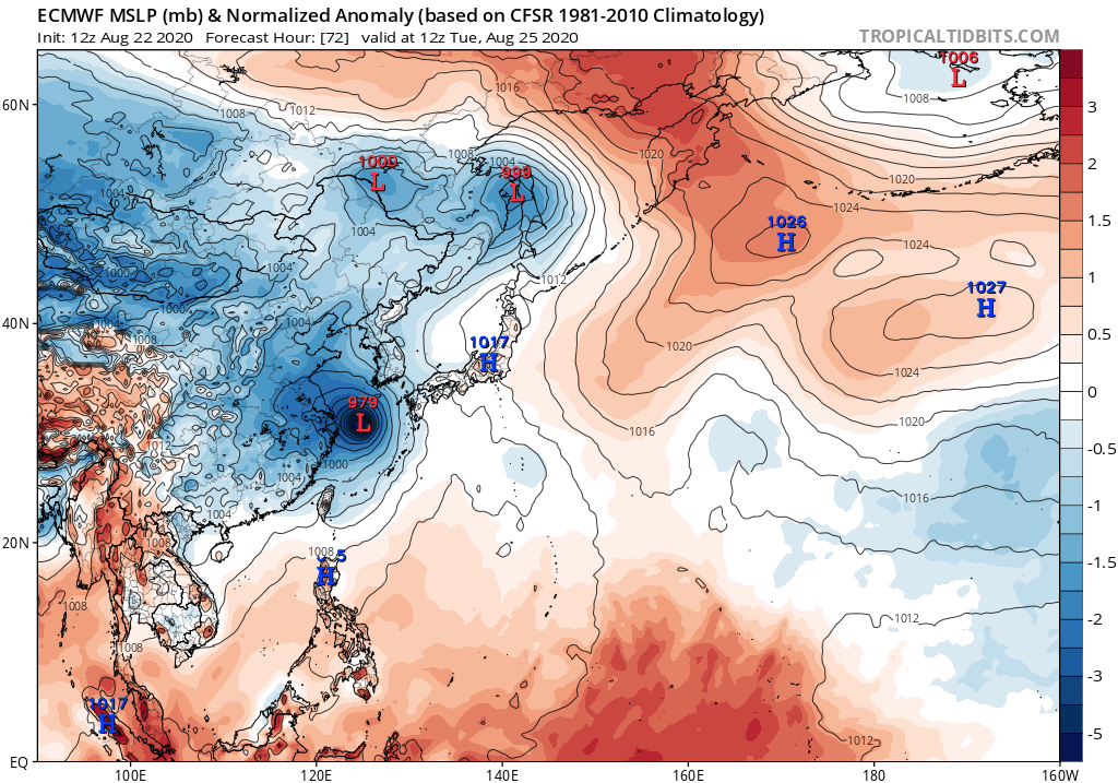
Re: WPAC: BAVI - Severe Tropical Storm
Shifted away from an SK landfall still very strong typhoon peak

0 likes
ヤンデレ女が寝取られるているのを見たい!!!
ECMWF ensemble NWPAC plots: https://ecmwfensnwpac.imgbb.com/
Multimodel NWPAC plots: https://multimodelnwpac.imgbb.com/
GFS Ensemble NWPAC plots (16 & 35 day forecast): https://gefsnwpac.imgbb.com/
Plots updated automatically
ECMWF ensemble NWPAC plots: https://ecmwfensnwpac.imgbb.com/
Multimodel NWPAC plots: https://multimodelnwpac.imgbb.com/
GFS Ensemble NWPAC plots (16 & 35 day forecast): https://gefsnwpac.imgbb.com/
Plots updated automatically
-
euro6208
Re: WPAC: BAVI - Severe Tropical Storm
Typhoon at 06Z?
TPPN10 PGTW 230244
A. TROPICAL STORM 09W (BAVI)
B. 23/0230Z
C. 26.49N
D. 124.09E
E. THREE/HMWRI8
F. T4.0/4.0/D2.0/24HRS STT: D0.5/03HRS
G. IR/EIR/VIS/MSI
H. REMARKS: 15A/PBO TIGHTLY CURVED BNDG/ANMTN. CNVCTN WRAPS .90
ON LOG10 SPIRAL YIELDING A DT OF 3.5. MET YIELDS 3.5 AND PT A
4.0. DBO PT.
I. ADDITIONAL POSITIONS:
22/2259Z 26.30N 123.68E SSMS
HEINS
0 likes
Who is online
Users browsing this forum: No registered users and 25 guests