
ATL: SALLY - Models
Moderator: S2k Moderators
Re: ATL: NINETEEN - Models
Some good bands if this verifies.
1 likes
The following post is NOT an official forecast and should not be used as such. It is just the opinion of the poster and may or may not be backed by sound meteorological data. It is NOT endorsed by any professional institution including storm2k.org For Official Information please refer to the NHC and NWS products.
-
eastcoastFL

- Category 5

- Posts: 3996
- Age: 44
- Joined: Thu Apr 12, 2007 12:29 pm
- Location: Palm City, FL
Re: ATL: NINETEEN - Models
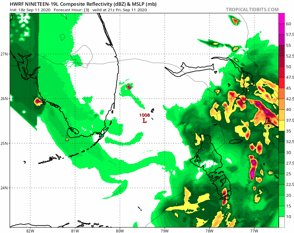
Hwrf 24 hours from now. Goes north then dips SW

1 likes
Personal Forecast Disclaimer:
The posts in this forum are NOT official forecast and should not be used as such. They are just the opinion of the poster and may or may not be backed by sound meteorological data. They are NOT endorsed by any professional institution or storm2k.org. For official information, please refer to the NHC and NWS products.
The posts in this forum are NOT official forecast and should not be used as such. They are just the opinion of the poster and may or may not be backed by sound meteorological data. They are NOT endorsed by any professional institution or storm2k.org. For official information, please refer to the NHC and NWS products.
-
eastcoastFL
- Category 5
- Posts: 3996
- Age: 44
- Joined: Thu Apr 12, 2007 12:29 pm
- Location: Palm City, FL
Re: ATL: NINETEEN - Models
Gets interesting as soon as it hits the gulf

0 likes
Personal Forecast Disclaimer:
The posts in this forum are NOT official forecast and should not be used as such. They are just the opinion of the poster and may or may not be backed by sound meteorological data. They are NOT endorsed by any professional institution or storm2k.org. For official information, please refer to the NHC and NWS products.
The posts in this forum are NOT official forecast and should not be used as such. They are just the opinion of the poster and may or may not be backed by sound meteorological data. They are NOT endorsed by any professional institution or storm2k.org. For official information, please refer to the NHC and NWS products.
Re: ATL: NINETEEN - Models
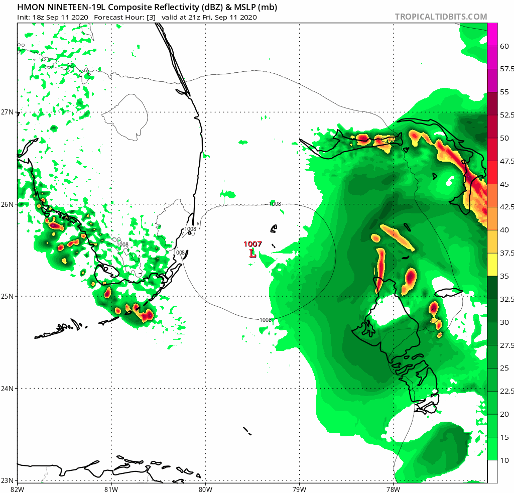
Hmon a little weaker but still good banding coming onshore.
0 likes
The following post is NOT an official forecast and should not be used as such. It is just the opinion of the poster and may or may not be backed by sound meteorological data. It is NOT endorsed by any professional institution including storm2k.org For Official Information please refer to the NHC and NWS products.
-
CrazyC83
- Professional-Met

- Posts: 34315
- Joined: Tue Mar 07, 2006 11:57 pm
- Location: Deep South, for the first time!
Re: ATL: NINETEEN - Models
The trough tries to push it up to the coast, but the ridge builds in at the last second...literally this is going to come down to a few hours or a few millibars.
1 likes
-
jasons2k

- Storm2k Executive

- Posts: 8290
- Age: 52
- Joined: Wed Jul 06, 2005 12:32 pm
- Location: The Woodlands, TX
Re: ATL: NINETEEN - Models
CrazyC83 wrote:The trough tries to push it up to the coast, but the ridge builds in at the last second...literally this is going to come down to a few hours or a few millibars.
Or a few miles. This center consolidation to the SW a bit could have some big track implications later on IMO. It will be interesting to see what the 00z ensemble models show overnight.
0 likes

Re: ATL: NINETEEN - Models
HWRF right at the Florida/Alabama border

0 likes
Personal Forecast Disclaimer:
The posts in this forum are NOT official forecast and should not be used as such. They are just the opinion of the poster and may or may not be backed by sound meteorological data. They are NOT endorsed by any professional institution or storm2k.org. For official information, please refer to the NHC and NWS products.
The posts in this forum are NOT official forecast and should not be used as such. They are just the opinion of the poster and may or may not be backed by sound meteorological data. They are NOT endorsed by any professional institution or storm2k.org. For official information, please refer to the NHC and NWS products.
Re: ATL: NINETEEN - Models
Wow this isn’t good. HWRF was the first to sniff out Laura’s intensity and now it has a 970MB headed towards the Alabama coast
0 likes

-
CrazyC83
- Professional-Met
- Posts: 34315
- Joined: Tue Mar 07, 2006 11:57 pm
- Location: Deep South, for the first time!
Re: ATL: NINETEEN - Models
jasons2k wrote:CrazyC83 wrote:The trough tries to push it up to the coast, but the ridge builds in at the last second...literally this is going to come down to a few hours or a few millibars.
Or a few miles. This center consolidation to the SW a bit could have some big track implications later on IMO. It will be interesting to see what the 00z ensemble models show overnight.
Elena may be an analog here if it tries to make that move but gets blocked and forced back west.
0 likes
-
CrazyC83
- Professional-Met
- Posts: 34315
- Joined: Tue Mar 07, 2006 11:57 pm
- Location: Deep South, for the first time!
Re: ATL: NINETEEN - Models
It's moving west there. This would be headed right for Lake Pontchartrain.
UPDATE: It would then stall out for a while off Mobile Bay. Talk about a rainmaker!!!
Last edited by CrazyC83 on Fri Sep 11, 2020 6:33 pm, edited 1 time in total.
0 likes
-
Hypercane_Kyle

- Category 5
- Posts: 3465
- Joined: Sat Mar 07, 2015 7:58 pm
- Location: Cape Canaveral, FL
Re: ATL: NINETEEN - Models
18z HWRF shows a high-end Cat 2.
0 likes
My posts are my own personal opinion, defer to the National Hurricane Center (NHC) and other NOAA products for decision making during hurricane season.
Re: ATL: NINETEEN - Models
bella_may wrote:Wow this isn’t good. HWRF was the first to sniff out Laura’s intensity and now it has a 970MB headed towards the Alabama coast
I'm absolutely NOT a model hugger, but the HWRF did pretty good with Laura.
0 likes
Personal Forecast Disclaimer:
The posts in this forum are NOT official forecast and should not be used as such. They are just the opinion of the poster and may or may not be backed by sound meteorological data. They are NOT endorsed by any professional institution or storm2k.org. For official information, please refer to the NHC and NWS products.
The posts in this forum are NOT official forecast and should not be used as such. They are just the opinion of the poster and may or may not be backed by sound meteorological data. They are NOT endorsed by any professional institution or storm2k.org. For official information, please refer to the NHC and NWS products.
-
Ivanhater

- Storm2k Moderator

- Posts: 11221
- Age: 39
- Joined: Fri Jul 01, 2005 8:25 am
- Location: Pensacola
Re: ATL: NINETEEN - Models
CrazyC83 wrote:
It's moving west there. This would be headed right for Lake Pontchartrain.
But is stil a scrap. That would be very damaging for places like Pensacola beach
0 likes
Michael
Re: ATL: NINETEEN - Models
Crawling the coast at 78 hours

0 likes
Personal Forecast Disclaimer:
The posts in this forum are NOT official forecast and should not be used as such. They are just the opinion of the poster and may or may not be backed by sound meteorological data. They are NOT endorsed by any professional institution or storm2k.org. For official information, please refer to the NHC and NWS products.
The posts in this forum are NOT official forecast and should not be used as such. They are just the opinion of the poster and may or may not be backed by sound meteorological data. They are NOT endorsed by any professional institution or storm2k.org. For official information, please refer to the NHC and NWS products.
-
Dean4Storms
- S2K Supporter

- Posts: 6358
- Age: 63
- Joined: Sun Aug 31, 2003 1:01 pm
- Location: Miramar Bch. FL
-
DestinHurricane

- Category 4

- Posts: 935
- Joined: Tue May 01, 2018 8:05 am
- Location: New York, NY
Re: ATL: NINETEEN - Models
Ivanhater wrote:CrazyC83 wrote:
It's moving west there. This would be headed right for Lake Pontchartrain.
But is stil a scrap. That would be very damaging for places like Pensacola beach
I am concerned that with the trends for a stronger storm we may see more east trends. This HWRF is a slight shift east from last run as well as the HMON.
Last edited by DestinHurricane on Fri Sep 11, 2020 6:37 pm, edited 1 time in total.
0 likes
Michael 2018
Re: ATL: NINETEEN - Models
Dean4Storms wrote:HMON into Ft. Walton Beach 982mb.
See and the HMON and HWRF pretty much tag teamed for Laura. That's another reason why I pay attention to both of these.
2 likes
Personal Forecast Disclaimer:
The posts in this forum are NOT official forecast and should not be used as such. They are just the opinion of the poster and may or may not be backed by sound meteorological data. They are NOT endorsed by any professional institution or storm2k.org. For official information, please refer to the NHC and NWS products.
The posts in this forum are NOT official forecast and should not be used as such. They are just the opinion of the poster and may or may not be backed by sound meteorological data. They are NOT endorsed by any professional institution or storm2k.org. For official information, please refer to the NHC and NWS products.
Re: ATL: NINETEEN - Models
DestinHurricane wrote:Ivanhater wrote:CrazyC83 wrote:
It's moving west there. This would be headed right for Lake Pontchartrain.
But is stil a scrap. That would be very damaging for places like Pensacola beach
I am concerned that with the trends for a stronger storm we may see more east trends. This HWRF is a slight shift east from last run as well as the HMON.
HWRF is the almost the same as the last run just a tad north and stronger
0 likes
Who is online
Users browsing this forum: Google Adsense [Bot] and 144 guests