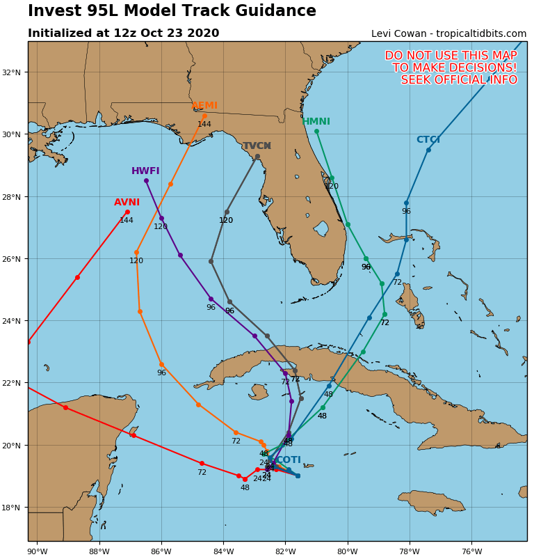
ATL: ZETA - Models

Moderator: S2k Moderators

Message
Author
AutoPenalti
Category 5
Category 5
Posts: 3950
Age: 27
Joined: Mon Aug 17, 2015 4:16 pm
Location: Ft. Lauderdale, Florida

Re: ATL: INVEST 95L - Models

#41 Postby AutoPenalti » Fri Oct 23, 2020 9:42 am

gatorcane wrote:
SFLcane wrote:12z models swinging eastward quite a bit.


https://i.postimg.cc/c4nPNNvK/95-L-tracks-12z.png

Literally a huge spread and still none take it to SFL

LMAO..
2 likes   
The posts in this forum are NOT official forecasts and should not be used as such. They are just the opinion of the poster and may or may not be backed by sound meteorological data. They are NOT endorsed by any professional institution or STORM2K. For official information, please refer to products from the NHC and NWS.


Model Runs Cheat Sheet:
GFS (5:30 AM/PM, 11:30 AM/PM)
HWRF, GFDL, UKMET, NAVGEM (6:30-8:00 AM/PM, 12:30-2:00 AM/PM)
ECMWF (1:45 AM/PM)

TCVN
is a weighted averaged

User avatar
kevin
Category 5
Category 5
Posts: 1776
Age: 25
Joined: Wed Aug 28, 2019 4:35 am

Re: ATL: INVEST 95L - Models

#42 Postby kevin » Fri Oct 23, 2020 9:49 am

The 12z models have started, first one as always is ICON. Let's see what it does this time.
0 likes   

User avatar
Iceresistance
Category 5
Category 5
Posts: 8927
Age: 20
Joined: Sat Oct 10, 2020 9:45 am
Location: Tecumseh, OK/Norman, OK

Re: ATL: INVEST 95L - Models

#43 Postby Iceresistance » Fri Oct 23, 2020 9:49 am

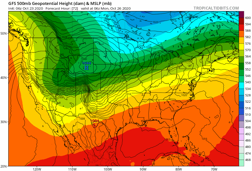
gatorcane wrote:Another look at the short wave over the Rockies the GFS moves quickly east. My hunch is that this system will be an Eastern Gulf threat and not a northern Gulf threat. Climo suggests that also.

https://i.postimg.cc/SKVmzzbY/gfs-z500-mslp-us-fh72-150.gif

I really don't know how to post these, but I think that it depends on how deep the Trough is.
0 likes   
Bill 2015 & Beta 2020

Winter 2020-2021 :cold:

All observations are in Tecumseh, OK unless otherwise noted.

Winter posts are focused mainly for Oklahoma & Texas.

Take any of my forecasts with a grain of salt, refer to the NWS, SPC, and NHC for official information

Never say Never with weather! Because ANYTHING is possible!

User avatar
Iceresistance
Category 5
Category 5
Posts: 8927
Age: 20
Joined: Sat Oct 10, 2020 9:45 am
Location: Tecumseh, OK/Norman, OK

Re: ATL: INVEST 95L - Models

#44 Postby Iceresistance » Fri Oct 23, 2020 10:09 am

kevin wrote:The 12z models have started, first one as always is ICON. Let's see what it does this time.

I always track the GFS model first, especially when there is winther weather or hurricanes coming
0 likes   
Bill 2015 & Beta 2020

Winter 2020-2021 :cold:

All observations are in Tecumseh, OK unless otherwise noted.

Winter posts are focused mainly for Oklahoma & Texas.

Take any of my forecasts with a grain of salt, refer to the NWS, SPC, and NHC for official information

Never say Never with weather! Because ANYTHING is possible!

User avatar
chris_fit
Category 5
Category 5
Posts: 3078
Joined: Wed Sep 10, 2003 11:58 pm
Location: Tampa Bay Area, FL
Contact:

Re: ATL: INVEST 95L - Models

#45 Postby chris_fit » Fri Oct 23, 2020 10:26 am

Is this the GFS Phantom we've been tracking for weeks coming to life?!?! (Albeit 3-4 days late) or is this a case of a broken clock is right twice a day? :grrr: :grrr:
0 likes   

tomatkins
Tropical Storm
Tropical Storm
Posts: 220
Joined: Wed Sep 05, 2018 2:11 pm

Re: ATL: INVEST 95L - Models

#46 Postby tomatkins » Fri Oct 23, 2020 10:29 am

chris_fit wrote:Is this the GFS Phantom we've been tracking for weeks coming to life?!?! (Albeit 3-4 days late) or is this a case of a broken clock is right twice a day? :grrr: :grrr:

It is the GFS phantom - look at the GFS from the 16-18 - this is where it thought this storm would be at this point, its just that it had started development further south and east and thus earlier.
0 likes   

User avatar
SouthFLTropics
Category 5
Category 5
Posts: 4156
Age: 48
Joined: Thu Aug 14, 2003 8:04 am
Location: Port St. Lucie, Florida

Re: ATL: INVEST 95L - Models

#47 Postby SouthFLTropics » Fri Oct 23, 2020 10:40 am

If 06z and 12z ICON is right, I'm thinking that someone has placed a cyclone magnet on the northern Gulf Coast. Didn't Josh Morgerman (iCyclone on Twitter) set up a central "base of operations" there this year? Maybe it's his fault.
2 likes   
Fourth Generation Floridian...With lots of storm knowledge passed down from my elders...

Personal Storm History: David 79, Andrew 92, Erin 95, Floyd 99, Irene 99, Frances 04, Jeanne 04, Wilma 05, Matthew 16, Irma 17

User avatar
Blown Away
S2K Supporter
S2K Supporter
Posts: 9868
Joined: Wed May 26, 2004 6:17 am

Re: ATL: INVEST 95L - Models

#48 Postby Blown Away » Fri Oct 23, 2020 10:41 am

Image
First TVCN post...
0 likes   
Hurricane Eye Experience: David 79, Irene 99, Frances 04, Jeanne 04, Wilma 05... EYE COMING MY WAY IN 2024…
Hurricane Brush Experience: Andrew 92, Erin 95, Floyd 99, Matthew 16, Irma 17, Ian 22, Nicole 22…

User avatar
SouthFLTropics
Category 5
Category 5
Posts: 4156
Age: 48
Joined: Thu Aug 14, 2003 8:04 am
Location: Port St. Lucie, Florida

Re: ATL: INVEST 95L - Models

#49 Postby SouthFLTropics » Fri Oct 23, 2020 10:42 am

TVCN likes Crystal River/Homosassa/Cedar Key area.
2 likes   
Fourth Generation Floridian...With lots of storm knowledge passed down from my elders...

Personal Storm History: David 79, Andrew 92, Erin 95, Floyd 99, Irene 99, Frances 04, Jeanne 04, Wilma 05, Matthew 16, Irma 17

User avatar
SFLcane
S2K Supporter
S2K Supporter
Posts: 9620
Age: 46
Joined: Sat Jun 05, 2010 1:44 pm
Location: Lake Worth Florida

Re: ATL: INVEST 95L - Models

#50 Postby SFLcane » Fri Oct 23, 2020 10:46 am

SouthFLTropics wrote:If 06z and 12z ICON is right, I'm thinking that someone has placed a cyclone magnet on the northern Gulf Coast. Didn't Josh Morgerman (iCyclone on Twitter) set up a central "base of operations" there this year? Maybe it's his fault.


I think it’s highly unlikely this gets as far north as the gulf coast. Image courtesy of stormrider on Twitter.

Image
2 likes   

User avatar
sunnyday
Category 5
Category 5
Posts: 1580
Joined: Thu Sep 04, 2003 8:16 pm

Re: ATL: INVEST 95L - Models

#51 Postby sunnyday » Fri Oct 23, 2020 10:59 am

Looks like same old, same old. I feel bad for Gulf Coast residents.
The exciting part is the one inch of rain for S Fl!
0 likes   

User avatar
SouthFLTropics
Category 5
Category 5
Posts: 4156
Age: 48
Joined: Thu Aug 14, 2003 8:04 am
Location: Port St. Lucie, Florida

Re: ATL: INVEST 95L - Models

#52 Postby SouthFLTropics » Fri Oct 23, 2020 11:00 am

SFLcane wrote:
SouthFLTropics wrote:If 06z and 12z ICON is right, I'm thinking that someone has placed a cyclone magnet on the northern Gulf Coast. Didn't Josh Morgerman (iCyclone on Twitter) set up a central "base of operations" there this year? Maybe it's his fault.


I think it’s highly unlikely this gets as far north as the gulf coast. Image courtesy of stormrider on Twitter.

https://i.imgr.com/54jM0E1.jpg


I would have to agree with you. Personally, I feel we are going to see a track very much like Irene in 1999. I did however see that HMON was showing the reverse S out of the Caribbean. I've been thinking since this whole thing started that it could have a track like that, similar to Matthew. It goes to show that those early runs of the GFS and GFS-Para weren't that crazy after all maybe. Time will tell, but many of us may need to apologize to the GFS.
4 likes   
Fourth Generation Floridian...With lots of storm knowledge passed down from my elders...

Personal Storm History: David 79, Andrew 92, Erin 95, Floyd 99, Irene 99, Frances 04, Jeanne 04, Wilma 05, Matthew 16, Irma 17

User avatar
SFLcane
S2K Supporter
S2K Supporter
Posts: 9620
Age: 46
Joined: Sat Jun 05, 2010 1:44 pm
Location: Lake Worth Florida

Re: ATL: INVEST 95L - Models

#53 Postby SFLcane » Fri Oct 23, 2020 11:04 am

SouthFLTropics wrote:
SFLcane wrote:
SouthFLTropics wrote:If 06z and 12z ICON is right, I'm thinking that someone has placed a cyclone magnet on the northern Gulf Coast. Didn't Josh Morgerman (iCyclone on Twitter) set up a central "base of operations" there this year? Maybe it's his fault.


I think it’s highly unlikely this gets as far north as the gulf coast. Image courtesy of stormrider on Twitter.

https://i.imgr.com/54jM0E1.jpg


I would have to agree with you. Personally, I feel we are going to see a track very much like Irene in 1999. I did however see that HMON was showing the reverse S out of the Caribbean. I've been thinking since this whole thing started that it could have a track like that, similar to Matthew. It goes to show that those early runs of the GFS and GFS-Para weren't that crazy after all maybe. Time will tell, but many of us may need to apologize to the GFS.


Image
0 likes   

Wx_Warrior
Category 5
Category 5
Posts: 2718
Joined: Thu Aug 03, 2006 3:58 pm
Location: Beaumont, TX

Re: ATL: INVEST 95L - Models

#54 Postby Wx_Warrior » Fri Oct 23, 2020 11:14 am

GFS 12z

Image
0 likes   

Nuno
Category 2
Category 2
Posts: 530
Joined: Fri Aug 30, 2019 8:35 am
Location: Coral Gables, FL

Re: ATL: INVEST 95L - Models

#55 Postby Nuno » Fri Oct 23, 2020 11:21 am

SFLcane wrote:
SouthFLTropics wrote:
SFLcane wrote:
I think it’s highly unlikely this gets as far north as the gulf coast. Image courtesy of stormrider on Twitter.

https://i.imgr.com/54jM0E1.jpg


I would have to agree with you. Personally, I feel we are going to see a track very much like Irene in 1999. I did however see that HMON was showing the reverse S out of the Caribbean. I've been thinking since this whole thing started that it could have a track like that, similar to Matthew. It goes to show that those early runs of the GFS and GFS-Para weren't that crazy after all maybe. Time will tell, but many of us may need to apologize to the GFS.


https://i.imgur.com/rmA2hyg.jpg


Often forgotten it seems. Vivid memories of standing water puddled all over Blockbuster the day after the storm. Lots of flooding in SFL from 99 Irene
0 likes   
Andrew (1992), Irene (1999), Frances (2004), Katrina (2005), Wilma (2005), Fay (2008), Irma (2017), Eta (2020), Ian (2022)

User avatar
Iceresistance
Category 5
Category 5
Posts: 8927
Age: 20
Joined: Sat Oct 10, 2020 9:45 am
Location: Tecumseh, OK/Norman, OK

Re: ATL: INVEST 95L - Models

#56 Postby Iceresistance » Fri Oct 23, 2020 11:39 am


GFS does not want the system to form, I'm still dealing with icy weather at the same time!
0 likes   
Bill 2015 & Beta 2020

Winter 2020-2021 :cold:

All observations are in Tecumseh, OK unless otherwise noted.

Winter posts are focused mainly for Oklahoma & Texas.

Take any of my forecasts with a grain of salt, refer to the NWS, SPC, and NHC for official information

Never say Never with weather! Because ANYTHING is possible!

User avatar
SouthFLTropics
Category 5
Category 5
Posts: 4156
Age: 48
Joined: Thu Aug 14, 2003 8:04 am
Location: Port St. Lucie, Florida

Re: ATL: INVEST 95L - Models

#57 Postby SouthFLTropics » Fri Oct 23, 2020 11:41 am

GFS and the CMC both have a similar solution. They both rip the disturbance into two pieces. One piece goes west towards the Yucatan and the other to the NE across South Florida and the Bahamas as a sheared mess.
0 likes   
Fourth Generation Floridian...With lots of storm knowledge passed down from my elders...

Personal Storm History: David 79, Andrew 92, Erin 95, Floyd 99, Irene 99, Frances 04, Jeanne 04, Wilma 05, Matthew 16, Irma 17

BobHarlem
Category 5
Category 5
Posts: 1666
Joined: Thu Oct 20, 2005 6:11 pm

Re: ATL: INVEST 95L - Models

#58 Postby BobHarlem » Fri Oct 23, 2020 11:48 am

The GFS doesn't jive with what the satellite shows right now, I'm not sure what to make of it yet.
0 likes   

User avatar
TheStormExpert
Category 5
Category 5
Posts: 8487
Age: 30
Joined: Wed Feb 16, 2011 5:38 pm
Location: Palm Beach Gardens, FL

Re: ATL: INVEST 95L - Models

#59 Postby TheStormExpert » Fri Oct 23, 2020 12:16 pm

SFLcane wrote:
SouthFLTropics wrote:
SFLcane wrote:
I think it’s highly unlikely this gets as far north as the gulf coast. Image courtesy of stormrider on Twitter.

https://i.imgr.com/54jM0E1.jpg


I would have to agree with you. Personally, I feel we are going to see a track very much like Irene in 1999. I did however see that HMON was showing the reverse S out of the Caribbean. I've been thinking since this whole thing started that it could have a track like that, similar to Matthew. It goes to show that those early runs of the GFS and GFS-Para weren't that crazy after all maybe. Time will tell, but many of us may need to apologize to the GFS.


https://i.imgur.com/rmA2hyg.jpg

I hope no Irene 1999 like track is in the cards. Don’t think the East Coast of Florida can handle much more rain, we’re saturated!
0 likes   
The following post is NOT an official forecast and should not be used as such. It is just the opinion of the poster and may or may not be backed by sound meteorological data. It is NOT endorsed by storm2k.org.

User avatar
gatorcane
S2K Supporter
S2K Supporter
Posts: 23499
Age: 46
Joined: Sun Mar 13, 2005 3:54 pm
Location: Boca Raton, FL

Re: ATL: INVEST 95L - Models

#60 Postby gatorcane » Fri Oct 23, 2020 12:27 pm

:eek:

HMON:
Image

HWRF:
Image
1 likes   


Return to “2020”

Who is online

Users browsing this forum: No registered users and 4 guests