ATL: CRISTOBAL - Models

Moderator: S2k Moderators

Message
Author
User avatar
TheProfessor
Professional-Met
Professional-Met
Posts: 3506
Age: 28
Joined: Tue Dec 03, 2013 10:56 am
Location: Wichita, Kansas

Re: ATL: CRISTOBAL - Models

#401 Postby TheProfessor » Wed Jun 03, 2020 10:28 am

MississippiWx wrote:The GFS, while not perfect, has probably had the best handle on this so far. The Canadian has done fairly decent as well. Euro could still be right from now on, but it has been outdone by the GFS so far. It will be interesting to see if it pops back out over water like the Euro shows.


The GFS hasn't down well with this storm yet. It could do well if this storm gets buried, dissipates, and a new storm forms from left over energy. If that happens then I'd consider it coup for the GFS. Outside of that, like the Euro, the GFS was too far west with this system and additionally was far too weak with intensification once it got into the BoC.
3 likes   
An alumnus of The Ohio State University.

Your local National Weather Service office is your best source for weather information.

User avatar
MississippiWx
S2K Supporter
S2K Supporter
Posts: 1696
Joined: Sat Aug 14, 2010 1:44 pm
Location: Hattiesburg, Mississippi

Re: ATL: CRISTOBAL - Models

#402 Postby MississippiWx » Wed Jun 03, 2020 10:35 am

TheProfessor wrote:
MississippiWx wrote:The GFS, while not perfect, has probably had the best handle on this so far. The Canadian has done fairly decent as well. Euro could still be right from now on, but it has been outdone by the GFS so far. It will be interesting to see if it pops back out over water like the Euro shows.


The GFS hasn't down well with this storm yet. It could do well if this storm gets buried, dissipates, and a new storm forms from left over energy. If that happens then I'd consider it coup for the GFS. Outside of that, like the Euro, the GFS was too far west with this system and additionally was far too weak with intensification once it got into the BoC.


The GFS isn’t really dissipating this system over land anymore. It appears to keep the same 850 vort together the whole time and brings it out north of the Yucatán. The Euro showed the two system idea as well a couple of days ago. The GFS has had the right general idea so far. The Euro could still beat it if Cristobal comes back over water in the BOC in a day or so.
0 likes   
This post is not an official forecast and should not be used as such. It is just the opinion of MississippiWx and may or may not be backed by sound meteorological data. It is not endorsed by any professional institution including storm2k.org. For Official Information please refer to the NHC and NWS products.

User avatar
TheProfessor
Professional-Met
Professional-Met
Posts: 3506
Age: 28
Joined: Tue Dec 03, 2013 10:56 am
Location: Wichita, Kansas

Re: ATL: CRISTOBAL - Models

#403 Postby TheProfessor » Wed Jun 03, 2020 10:39 am

MississippiWx wrote:
TheProfessor wrote:
MississippiWx wrote:The GFS, while not perfect, has probably had the best handle on this so far. The Canadian has done fairly decent as well. Euro could still be right from now on, but it has been outdone by the GFS so far. It will be interesting to see if it pops back out over water like the Euro shows.


The GFS hasn't down well with this storm yet. It could do well if this storm gets buried, dissipates, and a new storm forms from left over energy. If that happens then I'd consider it coup for the GFS. Outside of that, like the Euro, the GFS was too far west with this system and additionally was far too weak with intensification once it got into the BoC.


The GFS isn’t really dissipating this system over land anymore. It appears to keep the same 850 vort together the whole time and brings it out north of the Yucatán. The Euro showed the two system idea as well a couple of days ago. The GFS has had the right general idea so far. The Euro could still beat it if Cristobal comes back over water in the BOC in a day or so.


I don't really see it as any model beating another. It seems like they came to a consensus and met in the middle like the models typically do. Obviously things still need to play out, but the current line of thinking for a weak storm or depression to move off of the Mexican coast and if that's the case that's the models doing what they do almost all the time.
5 likes   
An alumnus of The Ohio State University.

Your local National Weather Service office is your best source for weather information.

Wx_Warrior
Category 5
Category 5
Posts: 2718
Joined: Thu Aug 03, 2006 3:58 pm
Location: Beaumont, TX

Re: ATL: CRISTOBAL - Models

#404 Postby Wx_Warrior » Wed Jun 03, 2020 11:14 am

GFS 12z

Image
2 likes   

User avatar
Steve
S2K Supporter
S2K Supporter
Posts: 9591
Joined: Sat Apr 05, 2003 11:41 pm
Location: Not a state-caster

Re: ATL: CRISTOBAL - Models

#405 Postby Steve » Wed Jun 03, 2020 11:18 am

GFS 12Z re-tightens the system with a pulse of energy on the northern tip of the Yucatan wrapping around the center near the NW Tip of the Yucatan but never gets it that strong. Makes a bit of a jog left at the LA Coast - looks to be weakening which is odd for a left moving storm there - and then moves on up NW into Oklahoma while dissipating. Total rainfall is pretty minimal with most of the immediate Gulf states seeing 2-4" which may be somewhat underdone. It landfalls between Grand Isle and Golden Meadow Sunday evening at 998mb.

ICON 12Z comes up the western side of the Yuctan near the coast, and moves toward the same area as the GFS but then kicks west and comes up through Acadiana near Vermilion Bay. Landfall (after hugging the coast for a half day or so) is Monday morning. ICON is a little stronger (mid 990's) but is even less bullish on rainfall as most of the coast has only a little rain and even impact areas get like 2-3". Trough catches it later and sends it up and out through Eastern Arkansas rather than moving it out NW toward Oklahoma.

CMC, Hurricane Models and then the EC are next up for the legit or semi-legit models.
1 likes   

User avatar
PTrackerLA
Category 5
Category 5
Posts: 5276
Age: 41
Joined: Thu Oct 10, 2002 8:40 pm
Location: Lafayette, LA

Re: ATL: CRISTOBAL - Models

#406 Postby PTrackerLA » Wed Jun 03, 2020 11:45 am

12z UKMET plotted here, anyone have the intensity?

Image
0 likes   

User avatar
Steve
S2K Supporter
S2K Supporter
Posts: 9591
Joined: Sat Apr 05, 2003 11:41 pm
Location: Not a state-caster

Re: ATL: CRISTOBAL - Models

#407 Postby Steve » Wed Jun 03, 2020 11:45 am

CMC has Cristobal emerging off the N Coast of the Yucatan at about 1002 in 60 hours - so it should be offshore by Thursday 7:00pm if it is accurate. We'll see where it goes from there.
0 likes   

User avatar
Siker
Category 4
Category 4
Posts: 904
Age: 28
Joined: Thu Oct 25, 2012 7:36 pm
Location: Miami, FL

Re: ATL: CRISTOBAL - Models

#408 Postby Siker » Wed Jun 03, 2020 11:51 am

PTrackerLA wrote:12z UKMET plotted here, anyone have the intensity?

https://i.imgur.com/JgCXrWm.gif


TROPICAL STORM CRISTOBAL ANALYSED POSITION : 18.6N 92.3W

ATCF IDENTIFIER : AL032020

LEAD CENTRAL MAXIMUM WIND
VERIFYING TIME TIME POSITION PRESSURE (MB) SPEED (KNOTS)
-------------- ---- -------- ------------- -------------
1200UTC 03.06.2020 0 18.6N 92.3W 999 34
0000UTC 04.06.2020 12 18.6N 92.0W 997 32
1200UTC 04.06.2020 24 18.0N 92.3W 1001 32
0000UTC 05.06.2020 36 CEASED TRACKING

NEW TROPICAL CYCLONE FORECAST TO DEVELOP AFTER 72 HOURS
FORECAST POSITION AT T+ 72 : 21.5N 89.3W

LEAD CENTRAL MAXIMUM WIND
VERIFYING TIME TIME POSITION PRESSURE (MB) SPEED (KNOTS)
-------------- ---- -------- ------------- -------------
1200UTC 06.06.2020 72 21.5N 89.3W 999 35
0000UTC 07.06.2020 84 24.6N 87.7W 996 40
1200UTC 07.06.2020 96 27.0N 87.6W 989 44
0000UTC 08.06.2020 108 27.7N 89.1W 986 44
1200UTC 08.06.2020 120 27.1N 90.8W 986 40
0000UTC 09.06.2020 132 28.0N 91.5W 985 48
1200UTC 09.06.2020 144 29.8N 92.5W 979 43
0 likes   

User avatar
dantonlsu
Tropical Depression
Tropical Depression
Posts: 95
Joined: Wed Aug 24, 2016 9:59 am

Re: ATL: CRISTOBAL - Models

#409 Postby dantonlsu » Wed Jun 03, 2020 11:53 am

Still think we will have a better grip on this once its back offshore.
0 likes   

User avatar
canetracker
S2K Supporter
S2K Supporter
Posts: 751
Age: 62
Joined: Wed Jul 27, 2005 8:49 pm
Location: Suburbia New Orleans...Harahan, LA

Re: ATL: CRISTOBAL - Models

#410 Postby canetracker » Wed Jun 03, 2020 11:53 am

Siker wrote:
PTrackerLA wrote:12z UKMET plotted here, anyone have the intensity?

https://i.imgur.com/JgCXrWm.gif


TROPICAL STORM CRISTOBAL ANALYSED POSITION : 18.6N 92.3W

ATCF IDENTIFIER : AL032020

LEAD CENTRAL MAXIMUM WIND
VERIFYING TIME TIME POSITION PRESSURE (MB) SPEED (KNOTS)
-------------- ---- -------- ------------- -------------
1200UTC 03.06.2020 0 18.6N 92.3W 999 34
0000UTC 04.06.2020 12 18.6N 92.0W 997 32
1200UTC 04.06.2020 24 18.0N 92.3W 1001 32
0000UTC 05.06.2020 36 CEASED TRACKING

NEW TROPICAL CYCLONE FORECAST TO DEVELOP AFTER 72 HOURS
FORECAST POSITION AT T+ 72 : 21.5N 89.3W

LEAD CENTRAL MAXIMUM WIND
VERIFYING TIME TIME POSITION PRESSURE (MB) SPEED (KNOTS)
-------------- ---- -------- ------------- -------------
1200UTC 06.06.2020 72 21.5N 89.3W 999 35
0000UTC 07.06.2020 84 24.6N 87.7W 996 40
1200UTC 07.06.2020 96 27.0N 87.6W 989 44
0000UTC 08.06.2020 108 27.7N 89.1W 986 44
1200UTC 08.06.2020 120 27.1N 90.8W 986 40
0000UTC 09.06.2020 132 28.0N 91.5W 985 48
1200UTC 09.06.2020 144 29.8N 92.5W 979 43


You can also use pivotal weather for the model animated graphic.

https://www.pivotalweather.com/model.ph ... lp&m=ukmet
1 likes   

User avatar
PTrackerLA
Category 5
Category 5
Posts: 5276
Age: 41
Joined: Thu Oct 10, 2002 8:40 pm
Location: Lafayette, LA

Re: ATL: CRISTOBAL - Models

#411 Postby PTrackerLA » Wed Jun 03, 2020 11:55 am

Siker wrote:
PTrackerLA wrote:12z UKMET plotted here, anyone have the intensity?

https://i.imgur.com/JgCXrWm.gif


TROPICAL STORM CRISTOBAL ANALYSED POSITION : 18.6N 92.3W

ATCF IDENTIFIER : AL032020

LEAD CENTRAL MAXIMUM WIND
VERIFYING TIME TIME POSITION PRESSURE (MB) SPEED (KNOTS)
-------------- ---- -------- ------------- -------------
1200UTC 03.06.2020 0 18.6N 92.3W 999 34
0000UTC 04.06.2020 12 18.6N 92.0W 997 32
1200UTC 04.06.2020 24 18.0N 92.3W 1001 32
0000UTC 05.06.2020 36 CEASED TRACKING

NEW TROPICAL CYCLONE FORECAST TO DEVELOP AFTER 72 HOURS
FORECAST POSITION AT T+ 72 : 21.5N 89.3W

LEAD CENTRAL MAXIMUM WIND
VERIFYING TIME TIME POSITION PRESSURE (MB) SPEED (KNOTS)
-------------- ---- -------- ------------- -------------
1200UTC 06.06.2020 72 21.5N 89.3W 999 35
0000UTC 07.06.2020 84 24.6N 87.7W 996 40
1200UTC 07.06.2020 96 27.0N 87.6W 989 44
0000UTC 08.06.2020 108 27.7N 89.1W 986 44
1200UTC 08.06.2020 120 27.1N 90.8W 986 40
0000UTC 09.06.2020 132 28.0N 91.5W 985 48
1200UTC 09.06.2020 144 29.8N 92.5W 979 43


Wow that a big uptick in intensity from previous runs.
0 likes   

stormlover2013

Re: ATL: CRISTOBAL - Models

#412 Postby stormlover2013 » Wed Jun 03, 2020 11:57 am

Ukmet stays over water and little more west
0 likes   

Aric Dunn
Category 5
Category 5
Posts: 21238
Age: 42
Joined: Sun Sep 19, 2004 9:58 pm
Location: Ready for the Chase.
Contact:

Re: ATL: CRISTOBAL - Models

#413 Postby Aric Dunn » Wed Jun 03, 2020 11:58 am

dantonlsu wrote:Still think we will have a better grip on this once its back offshore.


yeah it is entertaining to watch all the models they all are having issues with these short term motions... so until we have a solid motion we wont get that consensus everyone is looking for.

right now all we have is a general idea of timing.
Last edited by Aric Dunn on Wed Jun 03, 2020 12:00 pm, edited 1 time in total.
2 likes   
Note: If I make a post that is brief. Please refer back to previous posts for the analysis or reasoning. I do not re-write/qoute what my initial post said each time.
If there is nothing before... then just ask :)

Space & Atmospheric Physicist, Embry-Riddle Aeronautical University,
I believe the sky is falling...

jaguars_22
Category 2
Category 2
Posts: 571
Joined: Tue Jun 20, 2017 2:26 pm

Re: ATL: CRISTOBAL - Models

#414 Postby jaguars_22 » Wed Jun 03, 2020 11:59 am

Thats what i just saw! Is that high pressure over the southeast supposed to be weak enough to allow it to go north into lousiana? Is there a possibility the high is stronger??
0 likes   

User avatar
gatorcane
S2K Supporter
S2K Supporter
Posts: 23689
Age: 47
Joined: Sun Mar 13, 2005 3:54 pm
Location: Boca Raton, FL

Re: ATL: CRISTOBAL - Models

#415 Postby gatorcane » Wed Jun 03, 2020 12:00 pm

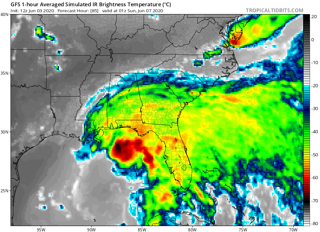
Typical lopsided June storm in the GOM as shown by the 12Z GFS satellite simulation. Note center is on far left side of red convection blob and is quite sheared. No reason to believe otherwise:

Image
1 likes   

User avatar
Siker
Category 4
Category 4
Posts: 904
Age: 28
Joined: Thu Oct 25, 2012 7:36 pm
Location: Miami, FL

Re: ATL: CRISTOBAL - Models

#416 Postby Siker » Wed Jun 03, 2020 12:03 pm

canetracker wrote:
Siker wrote:
PTrackerLA wrote:12z UKMET plotted here, anyone have the intensity?

https://i.imgur.com/JgCXrWm.gif


TROPICAL STORM CRISTOBAL ANALYSED POSITION : 18.6N 92.3W

ATCF IDENTIFIER : AL032020

LEAD CENTRAL MAXIMUM WIND
VERIFYING TIME TIME POSITION PRESSURE (MB) SPEED (KNOTS)
-------------- ---- -------- ------------- -------------
1200UTC 03.06.2020 0 18.6N 92.3W 999 34
0000UTC 04.06.2020 12 18.6N 92.0W 997 32
1200UTC 04.06.2020 24 18.0N 92.3W 1001 32
0000UTC 05.06.2020 36 CEASED TRACKING

NEW TROPICAL CYCLONE FORECAST TO DEVELOP AFTER 72 HOURS
FORECAST POSITION AT T+ 72 : 21.5N 89.3W

LEAD CENTRAL MAXIMUM WIND
VERIFYING TIME TIME POSITION PRESSURE (MB) SPEED (KNOTS)
-------------- ---- -------- ------------- -------------
1200UTC 06.06.2020 72 21.5N 89.3W 999 35
0000UTC 07.06.2020 84 24.6N 87.7W 996 40
1200UTC 07.06.2020 96 27.0N 87.6W 989 44
0000UTC 08.06.2020 108 27.7N 89.1W 986 44
1200UTC 08.06.2020 120 27.1N 90.8W 986 40
0000UTC 09.06.2020 132 28.0N 91.5W 985 48
1200UTC 09.06.2020 144 29.8N 92.5W 979 43


You can also use pivotal weather for the model animated graphic.

https://www.pivotalweather.com/model.ph ... lp&m=ukmet


Thanks for the link. The text product updates between 12:00-12:10 EDT, curious how quickly plots appear on pivotal weather.
0 likes   

Aric Dunn
Category 5
Category 5
Posts: 21238
Age: 42
Joined: Sun Sep 19, 2004 9:58 pm
Location: Ready for the Chase.
Contact:

Re: ATL: CRISTOBAL - Models

#417 Postby Aric Dunn » Wed Jun 03, 2020 12:04 pm

I cant even take any of the models seriously for the next 48 hours lol..

12z UKMET

Image
1 likes   
Note: If I make a post that is brief. Please refer back to previous posts for the analysis or reasoning. I do not re-write/qoute what my initial post said each time.
If there is nothing before... then just ask :)

Space & Atmospheric Physicist, Embry-Riddle Aeronautical University,
I believe the sky is falling...

User avatar
tailgater
S2K Supporter
S2K Supporter
Posts: 3339
Joined: Sun Jul 11, 2004 9:13 pm
Location: St. Amant La.

Re: ATL: CRISTOBAL - Models

#418 Postby tailgater » Wed Jun 03, 2020 12:23 pm

Looking back at the last 4 or 5 days at 12 z positions for the Gfs I would rate it as the poorest among the Gfs, Euro, CMC and Icon. None of them did very well.
1 likes   
The following post is NOT an official forecast and should not be used as such. It is just the opinion of the poster and may or may not be backed by sound meteorological data. It is NOT endorsed by any professional institution including storm2k.org For Official Information please refer to the NHC and NWS products.

User avatar
canetracker
S2K Supporter
S2K Supporter
Posts: 751
Age: 62
Joined: Wed Jul 27, 2005 8:49 pm
Location: Suburbia New Orleans...Harahan, LA

Re: ATL: CRISTOBAL - Models

#419 Postby canetracker » Wed Jun 03, 2020 12:26 pm

Siker wrote:
canetracker wrote:
Siker wrote:
TROPICAL STORM CRISTOBAL ANALYSED POSITION : 18.6N 92.3W

ATCF IDENTIFIER : AL032020

LEAD CENTRAL MAXIMUM WIND
VERIFYING TIME TIME POSITION PRESSURE (MB) SPEED (KNOTS)
-------------- ---- -------- ------------- -------------
1200UTC 03.06.2020 0 18.6N 92.3W 999 34
0000UTC 04.06.2020 12 18.6N 92.0W 997 32
1200UTC 04.06.2020 24 18.0N 92.3W 1001 32
0000UTC 05.06.2020 36 CEASED TRACKING

NEW TROPICAL CYCLONE FORECAST TO DEVELOP AFTER 72 HOURS
FORECAST POSITION AT T+ 72 : 21.5N 89.3W

LEAD CENTRAL MAXIMUM WIND
VERIFYING TIME TIME POSITION PRESSURE (MB) SPEED (KNOTS)
-------------- ---- -------- ------------- -------------
1200UTC 06.06.2020 72 21.5N 89.3W 999 35
0000UTC 07.06.2020 84 24.6N 87.7W 996 40
1200UTC 07.06.2020 96 27.0N 87.6W 989 44
0000UTC 08.06.2020 108 27.7N 89.1W 986 44
1200UTC 08.06.2020 120 27.1N 90.8W 986 40
0000UTC 09.06.2020 132 28.0N 91.5W 985 48
1200UTC 09.06.2020 144 29.8N 92.5W 979 43


You can also use pivotal weather for the model animated graphic.

https://www.pivotalweather.com/model.ph ... lp&m=ukmet


Thanks for the link. The text product updates between 12:00-12:10 EDT, curious how quickly plots appear on pivotal weather.


No problem. It was fully loaded in by 11:45 a.m. CDT.
3 likes   

User avatar
PTrackerLA
Category 5
Category 5
Posts: 5276
Age: 41
Joined: Thu Oct 10, 2002 8:40 pm
Location: Lafayette, LA

Re: ATL: CRISTOBAL - Models

#420 Postby PTrackerLA » Wed Jun 03, 2020 1:10 pm

12z Euro out to 72 hours, vorticity is much stronger than 00z run

0 likes   


Return to “2020”

Who is online

Users browsing this forum: No registered users and 35 guests