ATL: CRISTOBAL - Models

Moderator: S2k Moderators

Message
Author
User avatar
Steve
S2K Supporter
S2K Supporter
Posts: 9591
Joined: Sat Apr 05, 2003 11:41 pm
Location: Not a state-caster

Re: ATL: CRISTOBAL - Models

#421 Postby Steve » Wed Jun 03, 2020 1:18 pm

Aric Dunn wrote:
dantonlsu wrote:Still think we will have a better grip on this once its back offshore.


yeah it is entertaining to watch all the models they all are having issues with these short term motions... [b{ so until we have a solid motion we wont get that consensus everyone is looking for. [/b]

right now all we have is a general idea of timing.


Agreed and things could change and probably will. But if you don’t call this a consensus from 5 days out, I don’t know what is. Haha

https://my.sfwmd.gov/dbhydroplsql/dbhyd ... rm_display
2 likes   

User avatar
cycloneye
Admin
Admin
Posts: 143871
Age: 68
Joined: Thu Oct 10, 2002 10:54 am
Location: San Juan, Puerto Rico

Re: ATL: CRISTOBAL - Models

#422 Postby cycloneye » Wed Jun 03, 2020 1:23 pm

Stronger.

Image
0 likes   
Visit the Caribbean-Central America Weather Thread where you can find at first post web cams,radars
and observations from Caribbean basin members Click Here

CYCLONE MIKE
Category 5
Category 5
Posts: 2183
Joined: Tue Aug 31, 2004 6:04 pm
Location: Gonzales, LA

Re: ATL: CRISTOBAL - Models

#423 Postby CYCLONE MIKE » Wed Jun 03, 2020 1:24 pm

tailgater wrote:Looking back at the last 4 or 5 days at 12 z positions for the Gfs I would rate it as the poorest among the Gfs, Euro, CMC and Icon. None of them did very well.


I agree tailgater, let’s just all agree that no model has done very well. As gatorcane has been alluding to, all I see happening is just another typical sheared gulf system that will be fighting dry air once it makes it up this way. Will be breezy with a few inches of rain.
2 likes   
This post is NOT AN OFFICIAL FORECAST and should not be used as such. It is just the opinion of the poster and may or may not be backed by sound meteorological data. It is NOT endorsed by any professional institution including storm2k.org. For Official Information please refer to the NHC and NWS products.

Wx_Warrior
Category 5
Category 5
Posts: 2718
Joined: Thu Aug 03, 2006 3:58 pm
Location: Beaumont, TX

Re: ATL: CRISTOBAL - Models

#424 Postby Wx_Warrior » Wed Jun 03, 2020 1:25 pm

Euro 12Z...992mb

Image
Last edited by Wx_Warrior on Wed Jun 03, 2020 1:28 pm, edited 2 times in total.
1 likes   

User avatar
cycloneye
Admin
Admin
Posts: 143871
Age: 68
Joined: Thu Oct 10, 2002 10:54 am
Location: San Juan, Puerto Rico

Re: ATL: CRISTOBAL - Models

#425 Postby cycloneye » Wed Jun 03, 2020 1:26 pm

0 likes   
Visit the Caribbean-Central America Weather Thread where you can find at first post web cams,radars
and observations from Caribbean basin members Click Here

User avatar
Cpv17
Category 5
Category 5
Posts: 4917
Joined: Wed Dec 07, 2016 2:24 pm
Location: Wharton/El Campo, TX

Re: ATL: CRISTOBAL - Models

#426 Postby Cpv17 » Wed Jun 03, 2020 1:31 pm

12z Euro shifted slightly west from 0z.
0 likes   

User avatar
PTrackerLA
Category 5
Category 5
Posts: 5276
Age: 41
Joined: Thu Oct 10, 2002 8:40 pm
Location: Lafayette, LA

Re: ATL: CRISTOBAL - Models

#427 Postby PTrackerLA » Wed Jun 03, 2020 1:32 pm

12z Euro landfall @ 988mb

Image
3 likes   

User avatar
Jr0d
S2K Supporter
S2K Supporter
Posts: 1394
Joined: Tue Aug 27, 2019 10:52 am
Location: Cayo Hueso

Re: ATL: CRISTOBAL - Models

#428 Postby Jr0d » Wed Jun 03, 2020 1:33 pm

Steve wrote:Agreed and things could change and probably will. But if you don’t call this a consensus from 5 days out, I don’t know what is. Haha

https://my.sfwmd.gov/dbhydroplsql/dbhyd ... rm_display


Normally when the consensus is this tight, I would not question the track. However this time I have great uncertainty on the future track despite the consensus.

I think a track further east is possible, especially if Cristobal moves slower than forecast and catches a trough.
2 likes   

User avatar
tailgater
S2K Supporter
S2K Supporter
Posts: 3339
Joined: Sun Jul 11, 2004 9:13 pm
Location: St. Amant La.

Re: ATL: CRISTOBAL - Models

#429 Postby tailgater » Wed Jun 03, 2020 1:38 pm

I can’t post it but 12z Euro total precipitation shows area just west of New Orleans get up to 9 inch’s but most areas much less, largest totals well east near the Big bend area southward towards Tampa
1 likes   
The following post is NOT an official forecast and should not be used as such. It is just the opinion of the poster and may or may not be backed by sound meteorological data. It is NOT endorsed by any professional institution including storm2k.org For Official Information please refer to the NHC and NWS products.

User avatar
cycloneye
Admin
Admin
Posts: 143871
Age: 68
Joined: Thu Oct 10, 2002 10:54 am
Location: San Juan, Puerto Rico

Re: ATL: CRISTOBAL - Models

#430 Postby cycloneye » Wed Jun 03, 2020 1:42 pm

1 likes   
Visit the Caribbean-Central America Weather Thread where you can find at first post web cams,radars
and observations from Caribbean basin members Click Here

Stormcenter
S2K Supporter
S2K Supporter
Posts: 6677
Joined: Wed Sep 03, 2003 11:27 am
Location: Houston, TX

Re: ATL: CRISTOBAL - Models

#431 Postby Stormcenter » Wed Jun 03, 2020 1:50 pm

The models have been saying somewhere between
extreme SE TX to SE LA since last weekend. I don’t
understand
what the issue is with their performance. The consensus
is there right in front of us. The only question is the
ultimate strength if and when he makes landfall.
1 likes   

User avatar
Siker
Category 4
Category 4
Posts: 904
Age: 28
Joined: Thu Oct 25, 2012 7:36 pm
Location: Miami, FL

Re: ATL: CRISTOBAL - Models

#432 Postby Siker » Wed Jun 03, 2020 2:53 pm

12z EPS mean is a little stronger and further west with landfall:

Image
2 likes   

User avatar
Kingarabian
S2K Supporter
S2K Supporter
Posts: 15827
Joined: Sat Aug 08, 2009 3:06 am
Location: Honolulu, Hawaii

Re: ATL: CRISTOBAL - Models

#433 Postby Kingarabian » Wed Jun 03, 2020 3:04 pm

The UKMET is the strongest out of the global models. That's probably due to that weird hard left turn it's doing that eventually keeps it over water longer, compared to the other models solutions.
0 likes   
RIP Kobe Bryant

Aric Dunn
Category 5
Category 5
Posts: 21238
Age: 42
Joined: Sun Sep 19, 2004 9:58 pm
Location: Ready for the Chase.
Contact:

Re: ATL: CRISTOBAL - Models

#434 Postby Aric Dunn » Wed Jun 03, 2020 3:06 pm

Siker wrote:12z EPS mean is a little stronger and further west with landfall:

https://i.imgur.com/CzuaYfl.png


Took your image.. the little white dot is the current position...

it is going to have a real hard time reaching any of those EPS position.... Unless it stalls and waits for the timing to catch up. because it is already at the edge.

clearly there wont be that much of a south motion over the next 24 hours.. at least not how the Euro shows it..

maybe it will happen shifted east.. who knows..

Image
2 likes   
Note: If I make a post that is brief. Please refer back to previous posts for the analysis or reasoning. I do not re-write/qoute what my initial post said each time.
If there is nothing before... then just ask :)

Space & Atmospheric Physicist, Embry-Riddle Aeronautical University,
I believe the sky is falling...

User avatar
Steve
S2K Supporter
S2K Supporter
Posts: 9591
Joined: Sat Apr 05, 2003 11:41 pm
Location: Not a state-caster

Re: ATL: CRISTOBAL - Models

#435 Postby Steve » Wed Jun 03, 2020 5:01 pm

Jr0d wrote:
Steve wrote:Agreed and things could change and probably will. But if you don’t call this a consensus from 5 days out, I don’t know what is. Haha

https://my.sfwmd.gov/dbhydroplsql/dbhyd ... rm_display


Normally when the consensus is this tight, I would not question the track. However this time I have great uncertainty on the future track despite the consensus.

I think a track further east is possible, especially if Cristobal moves slower than forecast and catches a trough.


That’s why i said they probably will change. And consensus doesn’t mean right. But we have it.
0 likes   

User avatar
Dylan
Professional-Met
Professional-Met
Posts: 337
Age: 30
Joined: Mon May 31, 2010 9:50 am
Location: New Orleans, LA

Re: ATL: CRISTOBAL - Models

#436 Postby Dylan » Wed Jun 03, 2020 5:14 pm

1 likes   
Georges('98), Allison('01), Isidore('02), Lili('02), Frances('04) Ivan('04), Cindy('05), Katrina('05), Rita('05), Gustav('08), Isaac('12), Matthew('16), Harvey('17), Irma('17), Nate ('17), Ida ('21).

User avatar
gatorcane
S2K Supporter
S2K Supporter
Posts: 23689
Age: 47
Joined: Sun Mar 13, 2005 3:54 pm
Location: Boca Raton, FL

Re: ATL: CRISTOBAL - Models

#437 Postby gatorcane » Wed Jun 03, 2020 5:27 pm

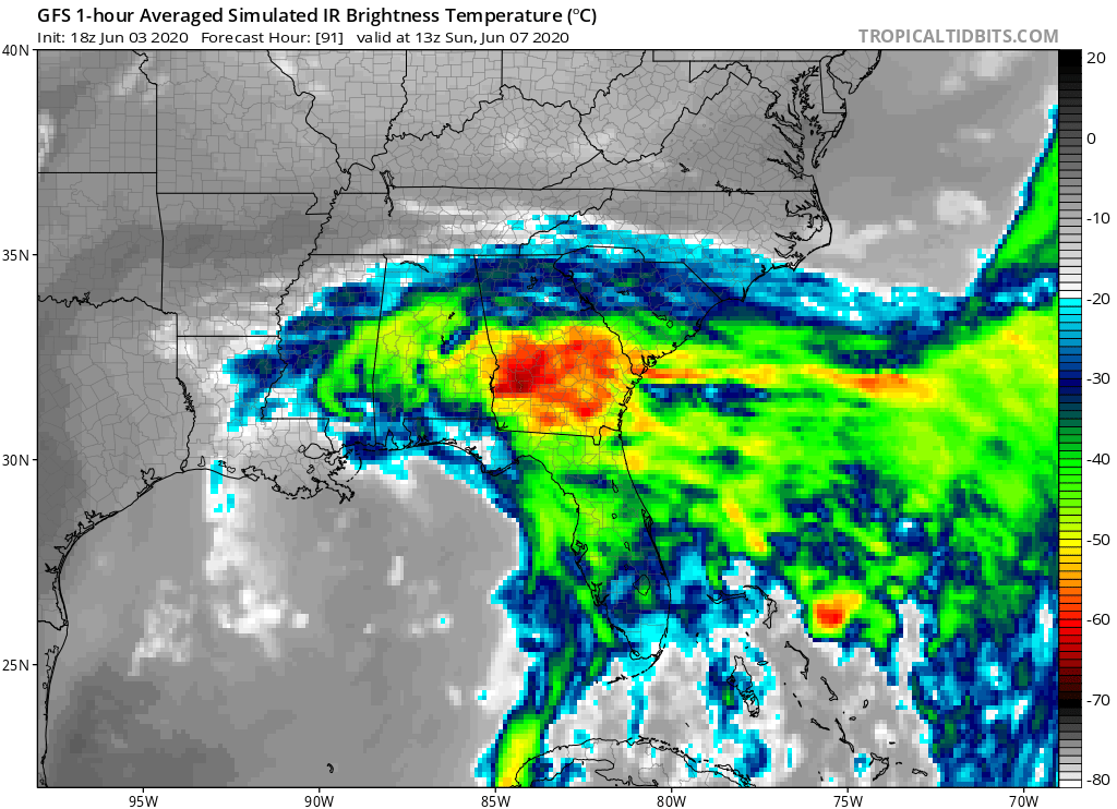
The 18Z GFS really ramps up the shear and dry continental air as it approaches the northern gulf coast. Convection well displaced to the east of the center.

Image
0 likes   

TheStormExpert

Re: ATL: CRISTOBAL - Models

#438 Postby TheStormExpert » Wed Jun 03, 2020 5:56 pm

gatorcane wrote:The 18Z GFS really ramps up the shear and dry continental air as it approaches the northern gulf coast. Convection well displaced to the east of the center.

https://i.postimg.cc/g29P45hp/gfs-ir-seus-16.png

May not even be tropical at that point, let alone subtropical.
1 likes   

TheStormExpert

Re: ATL: CRISTOBAL - Models

#439 Postby TheStormExpert » Wed Jun 03, 2020 6:00 pm

Siker wrote:12z EPS mean is a little stronger and further west with landfall:

https://i.imgur.com/CzuaYfl.png

Stronger? This looks like the weakest cycle yet in DAYS regarding the EPS Ensembles. Majority shoe nothing more than a TS with only a handful reaching Cat.1 hurricane status.

Image
0 likes   

Aric Dunn
Category 5
Category 5
Posts: 21238
Age: 42
Joined: Sun Sep 19, 2004 9:58 pm
Location: Ready for the Chase.
Contact:

Re: ATL: CRISTOBAL - Models

#440 Postby Aric Dunn » Wed Jun 03, 2020 6:13 pm

TheStormExpert wrote:
Siker wrote:12z EPS mean is a little stronger and further west with landfall:

https://i.imgur.com/CzuaYfl.png

Stronger? This looks like the weakest cycle yet in DAYS regarding the EPS Ensembles. Majority shoe nothing more than a TS with only a handful reaching Cat.1 hurricane status.

https://i.ibb.co/0svrp1X/2-F6-D9-C94-AAE0-4-FCC-87-F5-1-E437-DC683-AF.png


this is a funny graphic ...

im sure everyone else has notice the west bend then right hook over LA and Texas has been shifting east and closer to the coast as time goes by.. as long as Christobal keeps still and lags behind ... the trough will get closer..

soon enough we will start seeing models and members showing straight NE or NNE motion with no bend wnw
0 likes   
Note: If I make a post that is brief. Please refer back to previous posts for the analysis or reasoning. I do not re-write/qoute what my initial post said each time.
If there is nothing before... then just ask :)

Space & Atmospheric Physicist, Embry-Riddle Aeronautical University,
I believe the sky is falling...


Return to “2020”

Who is online

Users browsing this forum: No registered users and 36 guests