ATL: LAURA - Post-Tropical - Discussion
Moderator: S2k Moderators

Re: ATL: LAURA - Hurricane - Discussion
Ok, just finished with doing the sand bags to the back door, cleaned out the gutters, and brought in the majority of all furniture from outside. Tomorrow morning after waking up and seeing what is going on, will decided if I need to sand bag the 2 front doors, got a old shower door to dam up my back french doors. Hopefully I won't have to do those things and this thing will be going closer to Houston than closer to me.
5 likes
Personal Forecast Disclaimer:
The posts in this forum are NOT official forecast and should not be used as such. They are just the opinion of the poster and may or may not be backed by sound meteorological data. They are NOT endorsed by any professional institution or storm2k.org. For official information, please refer to the NHC and NWS products.
The posts in this forum are NOT official forecast and should not be used as such. They are just the opinion of the poster and may or may not be backed by sound meteorological data. They are NOT endorsed by any professional institution or storm2k.org. For official information, please refer to the NHC and NWS products.

Re: ATL: LAURA - Hurricane - Discussion
NotoSans wrote:This is a typical intensification pattern observed in WPAC storms - a large banding eye starts to form, then becomes obscure due to convective burst. Given current satellite presentation, I expect recon to find a 75-80kt hurricane.
Yeah I agree with this, you see them quite often in the WPAC. Often they end up becoming quite powerful systems 24-36hrs down the line, though from experience they often don't go quite stratospheric. However every system is different!
1 likes
Personal Forecast Disclaimer:
The posts in this forum are NOT official forecast and should not be used as such. They are just the opinion of the poster and may or may not be backed by sound meteorological data. They are NOT endorsed by any professional institution or storm2k.org. For official information, please refer to the NHC and NWS products
The posts in this forum are NOT official forecast and should not be used as such. They are just the opinion of the poster and may or may not be backed by sound meteorological data. They are NOT endorsed by any professional institution or storm2k.org. For official information, please refer to the NHC and NWS products
Re: ATL: LAURA - Hurricane - Discussion
NotoSans wrote:This is a typical intensification pattern observed in WPAC storms - a large banding eye starts to form, then becomes obscure due to convective burst. Given current satellite presentation, I expect recon to find a 75-80kt hurricane.
I think by the 7pm discussion we might see a 85-90 MPH Hurricane, and then by the Full 10 pm Advisory we might already have a 95-100 Hurricane, and then they would have to up the potential landfall strength to at least 125.
2 likes
Personal Forecast Disclaimer:
The posts in this forum are NOT official forecast and should not be used as such. They are just the opinion of the poster and may or may not be backed by sound meteorological data. They are NOT endorsed by any professional institution or storm2k.org. For official information, please refer to the NHC and NWS products.
The posts in this forum are NOT official forecast and should not be used as such. They are just the opinion of the poster and may or may not be backed by sound meteorological data. They are NOT endorsed by any professional institution or storm2k.org. For official information, please refer to the NHC and NWS products.
-
otowntiger
- Category 5

- Posts: 1932
- Joined: Tue Aug 31, 2004 7:06 pm
Re: ATL: LAURA - Hurricane - Discussion
wxman57 wrote:No change in NHC track - into Port Arthur around 3am Thursday. I have it about 30 miles west into High Island same time. Would rather the NHC be right.
What do you predict the intensity will be?
0 likes
-
SconnieCane
- Category 5
- Posts: 1013
- Joined: Thu Aug 02, 2018 5:29 pm
- Location: Madison, WI
Re: ATL: LAURA - Hurricane - Discussion
syfr wrote:Amazing that after scrubbing itself across half of North America, NHC shows her still reforming into a TS off of Cape Cod!
Well Laura did just track along or over all the Greater Antilles while maintaining or increasing organization...it laughs at land! Maybe it won't get as strong as we think because it doesn't know what to do with itself over open water!
5 likes
-
AnnularCane

- S2K Supporter

- Posts: 2959
- Joined: Thu Jun 08, 2006 9:18 am
- Location: Wytheville, VA
Re: ATL: LAURA - Hurricane - Discussion
storm_in_a_teacup wrote:On Space City Weather they're claiming the absolute worst case track for Houston (West end of Galveston or San Luis Pass landfall) is probably not going to happen...
Though I'm not sure "hey at least you get the left side" is much comfort for a Category 4+ storm if Laura bombs out...
Being on the left side didn't help New Orleans much for Katrina, although I'm guessing Houston's infrastructure isn't entirely the same. I guess it still floods easily there though, does it?
1 likes
Re: ATL: LAURA - Hurricane - Discussion
SconnieCane wrote:syfr wrote:Amazing that after scrubbing itself across half of North America, NHC shows her still reforming into a TS off of Cape Cod!
Well Laura did just track along or over all the Greater Antilles while maintaining or increasing organization...it laughs at land! Maybe it won't get as strong as we think because it doesn't know what to do with itself over open water!
Yeah should be a cat 5 by the time it reaches Missouri
8 likes
-
AnnularCane
- S2K Supporter
- Posts: 2959
- Joined: Thu Jun 08, 2006 9:18 am
- Location: Wytheville, VA
Re: ATL: LAURA - Hurricane - Discussion
ronyan wrote:SconnieCane wrote:syfr wrote:Amazing that after scrubbing itself across half of North America, NHC shows her still reforming into a TS off of Cape Cod!
Well Laura did just track along or over all the Greater Antilles while maintaining or increasing organization...it laughs at land! Maybe it won't get as strong as we think because it doesn't know what to do with itself over open water!
Yeah should be a cat 5 by the time it reaches Missouri
If that happens I'll be screwed! She's supposed to eventually pass over the mid-Atlantic too.
2 likes
Re: ATL: LAURA - Hurricane - Discussion
Are we going to have the observation and all the news posts thread???
https://www.katc.com/news/around-acadia ... q9Je_pgz6w
For those looking for news for SW Louisiana, you can check out KATC.COM or KLFY.COM
https://www.katc.com/news/around-acadia ... q9Je_pgz6w
For those looking for news for SW Louisiana, you can check out KATC.COM or KLFY.COM
Last edited by Blinhart on Tue Aug 25, 2020 4:50 pm, edited 1 time in total.
4 likes
Personal Forecast Disclaimer:
The posts in this forum are NOT official forecast and should not be used as such. They are just the opinion of the poster and may or may not be backed by sound meteorological data. They are NOT endorsed by any professional institution or storm2k.org. For official information, please refer to the NHC and NWS products.
The posts in this forum are NOT official forecast and should not be used as such. They are just the opinion of the poster and may or may not be backed by sound meteorological data. They are NOT endorsed by any professional institution or storm2k.org. For official information, please refer to the NHC and NWS products.
Re: ATL: LAURA - Hurricane - Discussion
AnnularCane wrote:ronyan wrote:SconnieCane wrote:
Well Laura did just track along or over all the Greater Antilles while maintaining or increasing organization...it laughs at land! Maybe it won't get as strong as we think because it doesn't know what to do with itself over open water!
Yeah should be a cat 5 by the time it reaches Missouri
If that happens I'll be screwed! She's supposed to eventually pass over the mid-Atlantic too.
It's 2020, I'm not counting anything out.
Seriously though a Cat 3 into the TX/LA border region is not ideal. Its going to cause some big issues in that area.
1 likes
// Opinions are my own, I am not a Meteorologist. Consult the NHC or Local NWS and Emergency Management for current information in your area. //
-
supercane4867
- Category 5
- Posts: 4966
- Joined: Wed Nov 14, 2012 10:43 am
Re: ATL: LAURA - Hurricane - Discussion
Hot towers developing and rotating around the eye are showing signs of continued intensification.

7 likes

Re: ATL: LAURA - Hurricane - Discussion
eastcoastFL wrote:GCANE wrote:The rapidly expanding outflow from the massive hot tower is pinching off the mid-level dry air feed from the ridge to the east.
IMHO its mostly steady intensification for the next 24 hrs.
Always amazing to see what a good, solid hot tower can do to change everything around so quickly.
https://i.imgur.com/vcPI9TU.png
Do you see any of your rosby waves or AWRBs around the gulf?
The Rossby Wave is outlined by the 250mb vort. Its driving the trough to Laura's west.
The ARWB is the big area of low to no shear where Laura is sitting in the middle of.


4 likes

Re: ATL: LAURA - Hurricane - Discussion
AnnularCane wrote:syfr wrote:Amazing that after scrubbing itself across half of North America, NHC shows her still reforming into a TS off of Cape Cod!
It actually shows her being post-tropical/extratropical by then.
Right you are ! Thanks for the correction (I edited my post).
Still quite impressive!
2 likes
I'm not a meteorologist, I'm an electronics engineer. While I can probably fix your toaster oven, you're not going to learn about storms from me!
New Mexico had no hurricanes. Then I moved to NC right before Fran.....
New Mexico had no hurricanes. Then I moved to NC right before Fran.....

Re: ATL: LAURA - Hurricane - Discussion
NotoSans wrote:This is a typical intensification pattern observed in WPAC storms - a large banding eye starts to form, then becomes obscure due to convective burst. Given current satellite presentation, I expect recon to find a 75-80kt hurricane.
I agree with that estimate, although I wouldn’t be surprised if she’s pushing Cat 2 status sometime during the mission.
0 likes
Irene '11 Sandy '12 Hermine '16 5/15/2018 Derecho Fay '20 Isaias '20 Elsa '21 Henri '21 Ida '21
I am only a meteorology enthusiast who knows a decent amount about tropical cyclones. Look to the professional mets, the NHC, or your local weather office for the best information.
I am only a meteorology enthusiast who knows a decent amount about tropical cyclones. Look to the professional mets, the NHC, or your local weather office for the best information.
Re: ATL: LAURA - Hurricane - Discussion
Think it defo going to be a major hurricane by the morning, then after that all bets are off unfortunately
4 likes
-
Nederlander
- S2K Supporter
- Posts: 1259
- Joined: Sat Jul 19, 2008 4:28 pm
- Location: Conroe, TX
Re: ATL: LAURA - Tropical Storm - Discussion
HoustonFrog wrote:Steve wrote:eastcoastFL wrote:
I sure hope so. Nobody wants to take 100kts sustained head on so port Arthur is probably one of the better options if it has to hit somewhere at all. It’s gonna be a scary 48 hours for the folks in that general area and it will probably be wide spread power outages as it rolls east across the country.
A lot of them just paid with Harvey and Ike and Rita all I’m the last 15 years. They could use a break.
It's the Moore,OK for hurricanes
And lesser known (less damage):
Hurricane Humberto (2007)
TS Edouard (2008)
TS Imelda (2019) - a little more damaging than the other two. Many Homes that flooded during Harvey flooded again
4 likes
-
AlabamaDave
- Tropical Storm

- Posts: 169
- Joined: Wed Aug 11, 2004 6:44 pm
Re: ATL: LAURA - Hurricane - Discussion
AnnularCane wrote:
Being on the left side didn't help New Orleans much for Katrina, although I'm guessing Houston's infrastructure isn't entirely the same. I guess it still floods easily there though, does it?
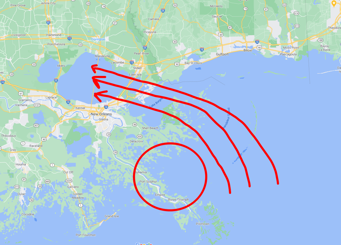
Someone correct me if I'm wrong, but I think most of NOLA's problems with Katrina came from the configuration of the bodies of water to the east and north of the city. As Katrina approached, she shoved a ton of water into Lake Borgne and Lake Pontchartrain around the north side of the circulation, which then rushed into the canal system of the city, overtopping and collapsing levees. Winds were not that big of an issue comparatively (probably Cat-1 sustained in the city?).
Last edited by AlabamaDave on Tue Aug 25, 2020 4:57 pm, edited 1 time in total.
2 likes
-
eastcoastFL

- Category 5
- Posts: 3996
- Age: 44
- Joined: Thu Apr 12, 2007 12:29 pm
- Location: Palm City, FL
Re: ATL: LAURA - Hurricane - Discussion
GCANE wrote:eastcoastFL wrote:GCANE wrote:The rapidly expanding outflow from the massive hot tower is pinching off the mid-level dry air feed from the ridge to the east.
IMHO its mostly steady intensification for the next 24 hrs.
Always amazing to see what a good, solid hot tower can do to change everything around so quickly.
https://i.imgur.com/vcPI9TU.png
Do you see any of your rosby waves or AWRBs around the gulf?
The Rossby Wave is outlined by the 250mb vort. Its driving the trough to Laura's west.
The ARWB is the big area of low to no shear where Laura is sitting in the middle of.
https://i.imgur.com/9x323f4.png
https://i.imgur.com/lcxXLc8.png
Thank you! My gcane bat signal worked and I got the info I was looking for!
3 likes
Personal Forecast Disclaimer:
The posts in this forum are NOT official forecast and should not be used as such. They are just the opinion of the poster and may or may not be backed by sound meteorological data. They are NOT endorsed by any professional institution or storm2k.org. For official information, please refer to the NHC and NWS products.
The posts in this forum are NOT official forecast and should not be used as such. They are just the opinion of the poster and may or may not be backed by sound meteorological data. They are NOT endorsed by any professional institution or storm2k.org. For official information, please refer to the NHC and NWS products.
Re: ATL: LAURA - Hurricane - Discussion
Yep weak eye getting filled over by the convection around the eyewall, a sure sign that this system is intensifying. Recon heading into Laura at the moment so we will get a better idea of where its current strength is.
Probably has a solid 24hrs of strengthening about to happen.
Probably has a solid 24hrs of strengthening about to happen.
4 likes
Personal Forecast Disclaimer:
The posts in this forum are NOT official forecast and should not be used as such. They are just the opinion of the poster and may or may not be backed by sound meteorological data. They are NOT endorsed by any professional institution or storm2k.org. For official information, please refer to the NHC and NWS products
The posts in this forum are NOT official forecast and should not be used as such. They are just the opinion of the poster and may or may not be backed by sound meteorological data. They are NOT endorsed by any professional institution or storm2k.org. For official information, please refer to the NHC and NWS products
-
Nederlander
- S2K Supporter
- Posts: 1259
- Joined: Sat Jul 19, 2008 4:28 pm
- Location: Conroe, TX
Re: ATL: LAURA - Hurricane - Discussion
AlabamaDave wrote:AnnularCane wrote:
Being on the left side didn't help New Orleans much for Katrina, although I'm guessing Houston's infrastructure isn't entirely the same. I guess it still floods easily there though, does it?
Someone correct me if I'm wrong, but I think most of NOLA's problems with Katrina came from the configuration of the bodies of water to the east and north of the city. As Katrina approached, she shoved a ton of water into Lake Borgne and Lake Pontchartrain around the north side of the circulation, which then rushed into the canal system of the city, overtopping and collapsing levees. Winds were not that big of an issue comparatively (probably Cat-1 sustained in the city?).
Yeah, it was her angle of approach. Southern MS sustained the most damage from winds
3 likes
Who is online
Users browsing this forum: No registered users and 6 guests