ATL: ISAIAS - Post-Tropical - Discussion
Moderator: S2k Moderators
-
HurricaneAndre2008

- Category 1

- Posts: 356
- Age: 28
- Joined: Wed Jul 31, 2019 9:51 pm
- Contact:
Re: ATL: INVEST 92L - Discussion
i think the SW portion of the system is the going to take over.
2 likes
Cindy(2005), Katrina(2005), Rita(2005), Erin(2007), Isaac(2012)
-
Aric Dunn
- Category 5

- Posts: 21238
- Age: 43
- Joined: Sun Sep 19, 2004 9:58 pm
- Location: Ready for the Chase.
- Contact:
Re: ATL: INVEST 92L - Discussion
A crazy deep moisture plume seen through all levels. this one is the 850 to 700 mb. but you can see it through all layers.
pretty crazy really.
http://tropic.ssec.wisc.edu/real-time/m ... anim=html5

pretty crazy really.
http://tropic.ssec.wisc.edu/real-time/m ... anim=html5
5 likes
Note: If I make a post that is brief. Please refer back to previous posts for the analysis or reasoning. I do not re-write/qoute what my initial post said each time.
If there is nothing before... then just ask
Space & Atmospheric Physicist, Embry-Riddle Aeronautical University,
I believe the sky is falling...
If there is nothing before... then just ask
Space & Atmospheric Physicist, Embry-Riddle Aeronautical University,
I believe the sky is falling...

Re: ATL: INVEST 92L - Discussion
HurricaneAndre2008 wrote:i think the SW portion of the system is the going to take over.
According to the euro in about 24-36hrs (from the 12z) is when the northern lobe takes over and has a more wnw motion so we'll know by then I'd assume.
3 likes
Re: ATL: INVEST 92L - Discussion
Aric Dunn wrote:A crazy deep moisture plume seen through all levels. this one is the 850 to 700 mb. but you can see it through all layers.
pretty crazy really.
http://tropic.ssec.wisc.edu/real-time/m ... anim=html5
https://i.ibb.co/wwqS9gf/sevtsevtsvb.gif
They don't call it the "tropical" Atlantic for nothing
I love to see images like this btw, very mesmerizing.
3 likes
-
DestinHurricane

- Category 4

- Posts: 935
- Joined: Tue May 01, 2018 8:05 am
- Location: New York, NY
Re: ATL: INVEST 92L - Discussion
Convection looking a little better on the SW side tonight. Maybe its starting to get its act together.
4 likes
Michael 2018
Re: ATL: INVEST 92L - Discussion
ScottNAtlanta wrote:The way this is barreling west...I dont see it gaining much latitude, The 18z GFS starts to develop the southern lobe and at 36 hours just kills it and develops the northern lobe which makes zero sense.
I agree because if you look at the steering in the shallower layers of the atmosphere (500-850mb - where a weaker system like this would most be influenced) the mean wind steering is pretty east to west (in fact a little WSW).

0 likes

Re: ATL: INVEST 92L - Discussion
Weatherwatcher2018 wrote:Can we expect any impacts here in Barbados
If it becomes a tropical storm while its center passes to our north (assuming it actually passes north), I think we'll be impacted to some degree. It's simply too big for us to completely escape. Storm force gusts are a real possibility IMHO. And even if it doesn't develop any further than its current state, we could still get quite a bit of rain.
1 likes
Re: ATL: INVEST 92L - Discussion
STRiZZY wrote:ScottNAtlanta wrote:The way this is barreling west...I dont see it gaining much latitude, The 18z GFS starts to develop the southern lobe and at 36 hours just kills it and develops the northern lobe which makes zero sense.
I agree because if you look at the steering in the shallower layers of the atmosphere (500-850mb - where a weaker system like this would most be influenced) the mean wind steering is pretty east to west (in fact a little WSW).
http://tropic.ssec.wisc.edu/real-time/atlantic/winds/wg8dlm2.GIF
Well I looked at the 12z euro's 500/850mb wind map and in about 24hrs (from the 12z) the mean steering to the south switches from east to west, to south to north which would explain the WNW track at that period in time.
You can see the barbs are coming from the south then...


0 likes
Re: ATL: INVEST 92L - Discussion
CM2 wrote:Weatherwatcher2018 wrote:CM2 wrote:Meanwhile it seems the south western lob is really getting it's stuff together. Storm might be much smaller than everyone is giving hype for.
https://imgur.com/X1DEWMI
So no impacts on Barbados then?
I can't tell you there won't be any for sure. There still is always the chance of very heavy rain reguardless which always comes with a chance of flash flooding and landslides on many of those mountainous islands. I would not disregard this system even if it doesn't form into a tropical system for you guys ...
Barbados isn't mountainous. We don't have a single mountain here. Trust me. I live here!
But we do have hills, and do occasionally get landslides, especially in the northeastern areas (like the parishes of St Andrew and St Joseph). But you're right that we shouldn't disregard 92L.
7 likes
Re: ATL: INVEST 92L - Discussion
abajan wrote:CM2 wrote:Weatherwatcher2018 wrote:
So no impacts on Barbados then?
I can't tell you there won't be any for sure. There still is always the chance of very heavy rain reguardless which always comes with a chance of flash flooding and landslides on many of those mountainous islands. I would not disregard this system even if it doesn't form into a tropical system for you guys ...
Barbados isn't mountainous. We don't have a single mountain here. Trust me. I live here!
But we do have hills, and do occasionally get landslides, especially in the northeastern areas (like the parishes of St Andrew and St Joseph). But you're right that we shouldn't disregard 92L.
Per the NHC "Rgeardless of development, locally heavy rains and gusty
winds are likely across portions of the Leeward Islands on Wednesday
and will spread westward to the Virgin Islands and Puerto Rico
Wednesday night and Thursday."
It doesn't mention the Windward Islands but given the size of 92l and the possibility of the southern lobe taking over, there's some chance of squally weather.
1 likes
-
SFLcane

- S2K Supporter

- Posts: 10281
- Age: 48
- Joined: Sat Jun 05, 2010 1:44 pm
- Location: Lake Worth Florida
Re: ATL: INVEST 92L - Discussion
Quite the hostle environment ahead for 92L. I will leave you with this sounding from Barbados. Very dry air up to 850-200mb.
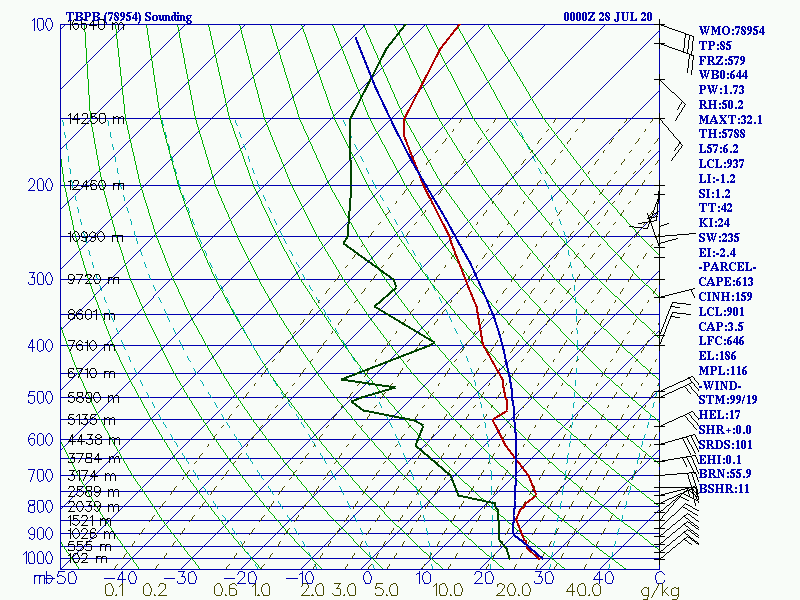
0 likes
-
curtadams
- S2K Supporter
- Posts: 1122
- Joined: Sun Aug 28, 2005 7:57 pm
- Location: Orange, California
- Contact:
Re: ATL: INVEST 92L - Discussion
tiger_deF wrote:Can anyone think of another invest that looked even remotely like this one in this location? Not only is it absolutely massive, but it has a vigor that I've never seen, and has been tapping into moisture streams all the way from the equator. With the current climatology and amount of dry air that was around this system, I think that any smaller wave would have been completely consumed.
[deleted; posted a hotlink]
Last edited by curtadams on Mon Jul 27, 2020 10:36 pm, edited 1 time in total.
0 likes
-
GeneratorPower

- S2K Supporter
- Posts: 1648
- Age: 46
- Joined: Sun Dec 18, 2005 11:48 pm
- Location: Huntsville, AL
Re: ATL: INVEST 92L - Discussion
curtadams wrote:tiger_deF wrote:Can anyone think of another invest that looked even remotely like this one in this location? Not only is it absolutely massive, but it has a vigor that I've never seen, and has been tapping into moisture streams all the way from the equator. With the current climatology and amount of dry air that was around this system, I think that any smaller wave would have been completely consumed.
Dolly 2008. Here's a pic posted to the Storm2K discussion thread by CycloneEye when it was still an invest:
http://sirocco.accuweather.com/sat_mosaic_640x480_public/ir/isacatl.gif
Better looking than our current invest, but similar with convection fore and aft around a dry center. Didn't actually form officially for the next 2000 miles.
That’s 92L
3 likes
-
TheProfessor

- Professional-Met

- Posts: 3506
- Age: 29
- Joined: Tue Dec 03, 2013 10:56 am
- Location: Wichita, Kansas
Re: ATL: INVEST 92L - Discussion
GeneratorPower wrote:curtadams wrote:tiger_deF wrote:Can anyone think of another invest that looked even remotely like this one in this location? Not only is it absolutely massive, but it has a vigor that I've never seen, and has been tapping into moisture streams all the way from the equator. With the current climatology and amount of dry air that was around this system, I think that any smaller wave would have been completely consumed.
Dolly 2008. Here's a pic posted to the Storm2K discussion thread by CycloneEye when it was still an invest:
http://sirocco.accuweather.com/sat_mosaic_640x480_public/ir/isacatl.gif
Better looking than our current invest, but similar with convection fore and aft around a dry center. Didn't actually form officially for the next 2000 miles.
That’s 92L
Ah, a classic case of not hosting the image and just putting the source of the image, which updates over time. I see it all the time when I go back through old winter storm threads and there would be a radar image of the snow storm except now it's just a stray shower that happens to be on radar at the current moment.
6 likes
An alumnus of The Ohio State University.
Your local National Weather Service office is your best source for weather information.
Your local National Weather Service office is your best source for weather information.
-
curtadams
- S2K Supporter
- Posts: 1122
- Joined: Sun Aug 28, 2005 7:57 pm
- Location: Orange, California
- Contact:
Re: ATL: INVEST 92L - Discussion
OK, here's a real pre-Dolly image:

Much better looking than 92L. Similar in being very big (tho not so obvious at that angle). But still not a cyclone for some time after the pic.
Much better looking than 92L. Similar in being very big (tho not so obvious at that angle). But still not a cyclone for some time after the pic.
4 likes
Re: ATL: INVEST 92L - Discussion
curtadams wrote:OK, here's a real pre-Dolly image:
http://www.fotothing.com/photos/us/40209.jpg
Much better looking than 92L. Similar in being very big (tho not so obvious at that angle). But still not a cyclone for some time after the pic.
Oh ok I see now haha!
0 likes
-
AutoPenalti
- Category 5
- Posts: 4091
- Age: 29
- Joined: Mon Aug 17, 2015 4:16 pm
- Location: Ft. Lauderdale, Florida
Re: ATL: INVEST 92L - Discussion
So we went from pretty favorable conditions (2 pages ago) to unfavorable conditions (in this page) 
1 likes
The posts in this forum are NOT official forecasts and should not be used as such. They are just the opinion of the poster and may or may not be backed by sound meteorological data. They are NOT endorsed by any professional institution or STORM2K. For official information, please refer to products from the NHC and NWS.
Model Runs Cheat Sheet:
GFS (5:30 AM/PM, 11:30 AM/PM)
HWRF, GFDL, UKMET, NAVGEM (6:30-8:00 AM/PM, 12:30-2:00 AM/PM)
ECMWF (1:45 AM/PM)
TCVN is a weighted averaged

Re: ATL: INVEST 92L - Discussion
CourierPR wrote:tiger_deF wrote:Can anyone think of another invest that looked even remotely like this one in this location? Not only is it absolutely massive, but it has a vigor that I've never seen, and has been tapping into moisture streams all the way from the equator. With the current climatology and amount of dry air that was around this system, I think that any smaller wave would have been completely consumed.
Climatology is the scientific study of climate (= general or long-term weather conditions) The last part of the definition is key--General or long-term weather conditions. Climatology is not a force unto itself and using the phrase "current climatology" is a misnomer.
I think the dude was just kinda wondering whether a similar sized Tropical disturbance ever occured before. Someone correct me if I'm wrong.
1 likes
Andy D
(For official information, please refer to the NHC and NWS products.)
(For official information, please refer to the NHC and NWS products.)
Re: ATL: INVEST 92L - Discussion
chaser1 wrote:CourierPR wrote:tiger_deF wrote:Can anyone think of another invest that looked even remotely like this one in this location? Not only is it absolutely massive, but it has a vigor that I've never seen, and has been tapping into moisture streams all the way from the equator. With the current climatology and amount of dry air that was around this system, I think that any smaller wave would have been completely consumed.
Climatology is the scientific study of climate (= general or long-term weather conditions) The last part of the definition is key--General or long-term weather conditions. Climatology is not a force unto itself and using the phrase "current climatology" is a misnomer.
I think the dude was just kinda wondering whether a similar sized Tropical disturbance ever occured before. Someone correct me if I'm wrong.
That's what my impression was.
1 likes
Who is online
Users browsing this forum: No registered users and 30 guests