ATL: GONZALO - Models

Moderator: S2k Moderators

Message
Author
User avatar
SFLcane
S2K Supporter
S2K Supporter
Posts: 9627
Age: 46
Joined: Sat Jun 05, 2010 1:44 pm
Location: Lake Worth Florida

Re: ATL: SEVEN - Models

#61 Postby SFLcane » Tue Jul 21, 2020 8:09 pm

Aric Dunn wrote:18z hwrf/hmon updating for anyone ?


976mb at one point

Image
3 likes   

Aric Dunn
Category 5
Category 5
Posts: 21228
Age: 41
Joined: Sun Sep 19, 2004 9:58 pm
Location: Ready for the Chase.
Contact:

Re: ATL: SEVEN - Models

#62 Postby Aric Dunn » Tue Jul 21, 2020 8:29 pm

18z Euro brings it to 65 mph.
0 likes   
Note: If I make a post that is brief. Please refer back to previous posts for the analysis or reasoning. I do not re-write/qoute what my initial post said each time.
If there is nothing before... then just ask :)

Space & Atmospheric Physicist, Embry-Riddle Aeronautical University,
I believe the sky is falling...

User avatar
Highteeld
Category 5
Category 5
Posts: 2097
Age: 40
Joined: Tue Jan 30, 2018 9:10 pm
Location: Chicago

Re: ATL: SEVEN - Models

#63 Postby Highteeld » Tue Jul 21, 2020 8:52 pm

SHIPS RI probs:

.SHIPS Prob RI for 20kt/ 12hr RI threshold= 7% is 1.4 times climatological mean ( 5.0%)
SHIPS Prob RI for 25kt/ 24hr RI threshold= 20% is 1.8 times climatological mean (10.9%)
SHIPS Prob RI for 30kt/ 24hr RI threshold= 15% is 2.1 times climatological mean ( 6.9%)
SHIPS Prob RI for 35kt/ 24hr RI threshold= 11% is 2.9 times climatological mean ( 3.9%)
SHIPS Prob RI for 40kt/ 24hr RI threshold= 10% is 4.0 times climatological mean ( 2.5%)
SHIPS Prob RI for 45kt/ 36hr RI threshold= 12% is 2.6 times climatological mean ( 4.6%)
SHIPS Prob RI for 55kt/ 48hr RI threshold= 13% is 2.8 times climatological mean ( 4.6%)
SHIPS Prob RI for 65kt/ 72hr RI threshold= 21% is 4.1 times climatological mean ( 5.2%)
1 likes   
Very useful information on the Dvorak Technique --

https://severe.worldweather.wmo.int/TCF ... kBeven.pdf

User avatar
NDG
S2K Supporter
S2K Supporter
Posts: 14945
Joined: Sun Jul 09, 2006 10:14 pm
Location: Orlando, FL

Re: ATL: SEVEN - Models

#64 Postby NDG » Tue Jul 21, 2020 9:08 pm

Aric Dunn wrote:18z Euro .. a little stronger.

https://i.ibb.co/rFQBXVX/modezrpd-20200722-0200-animation.gif
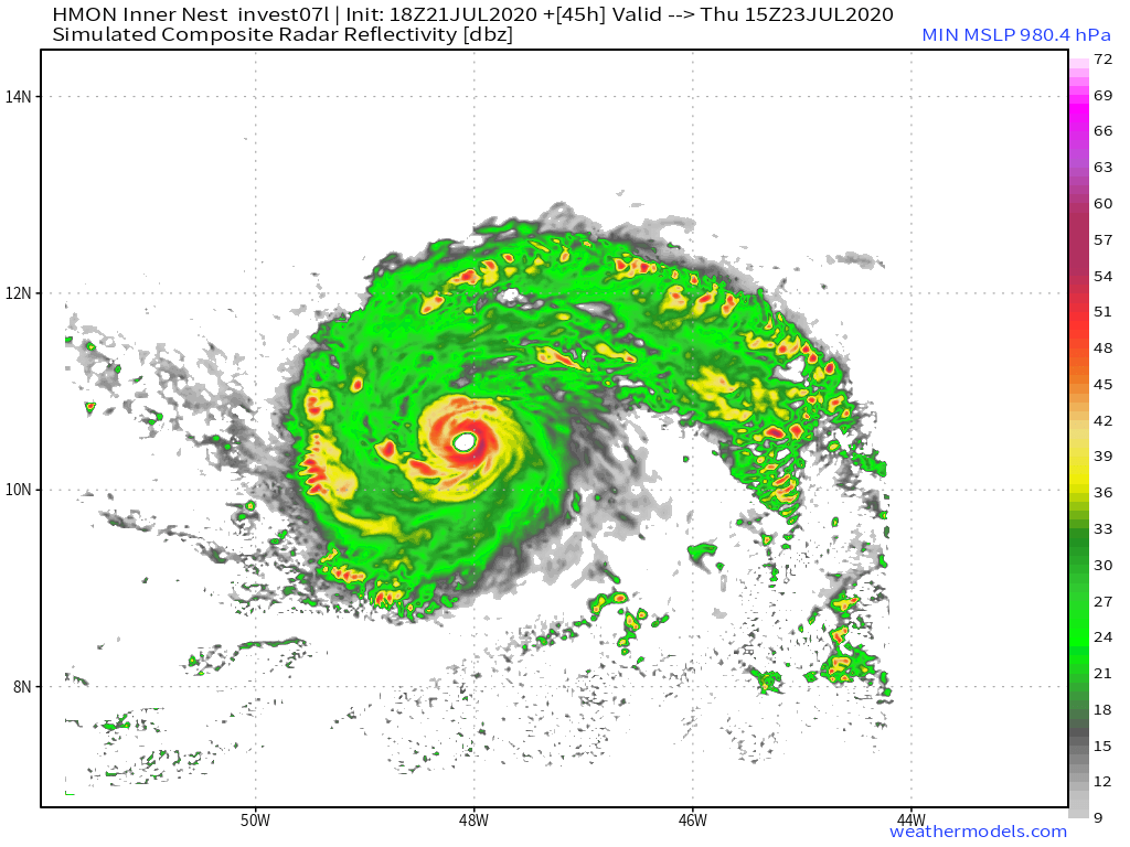

It also shows that UL winds should be favorable as it approaches the Windward Islands and it keeps its pocket of moisture.

Image
Image
Image
1 likes   

User avatar
NDG
S2K Supporter
S2K Supporter
Posts: 14945
Joined: Sun Jul 09, 2006 10:14 pm
Location: Orlando, FL

Re: ATL: SEVEN - Models

#65 Postby NDG » Tue Jul 21, 2020 9:12 pm

SFLcane wrote:
Aric Dunn wrote:18z hwrf/hmon updating for anyone ?


976mb at one point

https://iili.io/dxBE6F.png


18z HWRF is weaker than previous runs.

Image
2 likes   

User avatar
ColdMiser123
Professional-Met
Professional-Met
Posts: 780
Age: 27
Joined: Mon Sep 26, 2016 3:26 pm
Location: Northeast US

Re: ATL: SEVEN - Models

#66 Postby ColdMiser123 » Tue Jul 21, 2020 10:49 pm

GFS is significantly stronger in the short-term compared to previous runs, which has implications both for track and impacts to the Windward Islands. Small cyclones can both spin up and spin down quickly which makes forecasting intensity difficult.

I would still expect this run to show the circulation falling apart post islands.
1 likes   
B.S., M.S., Meteorology & Atmospheric Science

User avatar
NDG
S2K Supporter
S2K Supporter
Posts: 14945
Joined: Sun Jul 09, 2006 10:14 pm
Location: Orlando, FL

Re: ATL: SEVEN - Models

#67 Postby NDG » Tue Jul 21, 2020 11:07 pm

GFS continues with its trend of getting future Gonzalo stronger on each run through the eastern Caribbean.
0 likes   

User avatar
Hurricaneman
Category 5
Category 5
Posts: 7284
Age: 43
Joined: Tue Aug 31, 2004 3:24 pm
Location: central florida

Re: ATL: SEVEN - Models

#68 Postby Hurricaneman » Tue Jul 21, 2020 11:11 pm

ColdMiser123 wrote:GFS is significantly stronger in the short-term compared to previous runs, which has implications both for track and impacts to the Windward Islands. Small cyclones can both spin up and spin down quickly which makes forecasting intensity difficult.

I would still expect this run to show the circulation falling apart post islands.


Well the 0zGFS has this survive past the longitude of Hispaniola so if somehow it survives past that this could be big trouble in the long run, but I’m thinking the GFS might be overestimating this
0 likes   

USTropics
Category 5
Category 5
Posts: 2422
Joined: Sun Aug 12, 2007 3:45 am
Location: Florida State University

Re: ATL: SEVEN - Models

#69 Postby USTropics » Tue Jul 21, 2020 11:16 pm

This is one of those systems where the 3-5 day intensity forecast is critical. The trend, slower and stronger adjustments with each run (and these are just in the 72-120 hour range), will have have large implications on if TD7 can survive a trek through the eastern Caribbean.

3 day trend:
Image

5 day trend:
Image
3 likes   

User avatar
Ubuntwo
Category 5
Category 5
Posts: 1089
Age: 30
Joined: Thu Oct 05, 2017 10:41 pm

Re: ATL: SEVEN - Models

#70 Postby Ubuntwo » Wed Jul 22, 2020 1:05 am

0z Euro is in contrast to almost every other model, with a short 1004mb peak at h12 followed by weakening. Lots of intensity uncertainty.
Image
1 likes   
Kendall -> SLO -> PBC

Memorable Storms: Katrina (for its Florida landfall...) Wilma Matthew Irma

User avatar
SFLcane
S2K Supporter
S2K Supporter
Posts: 9627
Age: 46
Joined: Sat Jun 05, 2010 1:44 pm
Location: Lake Worth Florida

Re: ATL: SEVEN - Models

#71 Postby SFLcane » Wed Jul 22, 2020 3:26 am

Potent hurricane on the 06zHWRF down to about 970mb as it crosses the islands.

Image
0 likes   

User avatar
NDG
S2K Supporter
S2K Supporter
Posts: 14945
Joined: Sun Jul 09, 2006 10:14 pm
Location: Orlando, FL

Re: ATL: SEVEN - Models

#72 Postby NDG » Wed Jul 22, 2020 6:50 am

Despite the 06z GFS weakening it sooner in the Caribbean than previous 2 runs, is gaining ensemble members of it making it across the Caribbean.

Image
0 likes   

User avatar
drezee
S2K Supporter
S2K Supporter
Posts: 3644
Joined: Mon Jun 09, 2003 12:49 pm
Location: FL

Re: ATL: SEVEN - Tropical Depression - Discussion

#73 Postby drezee » Wed Jul 22, 2020 6:51 am

Shell Mound wrote:

Emily is in no way comparable to this system. From the very first advisory on Emily:

Source

Keep reading...

MIATCDAT5 ALL
TTAA00 KNHC DDHHMM
TROPICAL DEPRESSION FIVE DISCUSSION NUMBER 3
NWS TPC/NATIONAL HURRICANE CENTER MIAMI FL
11 AM EDT MON JUL 11 2005

VISIBLE IMAGERY REVEALS THAT THE DEPRESSION IS NOT WELL ORGANIZED...
WITH A LOW-LEVEL CIRCULATION LOCATED ALONG THE EASTERN EDGE OF THE
DEEP CONVECTION...ABOUT 80 NM TO THE EAST OF THE MID-LEVEL TURNING.
A QUIKSCAT PASS AT 09Z SUGGESTED THAT THIS SMALL LOW-LEVEL
CIRCULATION MAY MERELY BE A SWIRL EMBEDDED WITHIN AN ILL-DEFINED
BROADER LOW. IMPROVED BANDING FEATURES TO THE SOUTHWEST OVER THE
PAST FEW HOURS ALSO SUGGEST THAT IT IS THE BROADER LOW THAT MAY
ULTIMATELY PREVAIL. RATHER THAN JERK THE TRACK BACK TO THE EAST TO
FOLLOW THE SWIRL...I PREFER TO FOLLOW THE BROADER SYSTEM AT THIS
TIME. THE POOR ORGANIZATION OF THE SYSTEM...AND DVORAK
CLASSIFICATIONS FROM TAFB AND SAB OF T2.0...ARE GOOD REASONS NOT TO
UPGRADE THE DEPRESSION TO A TROPICAL STORM.

WHILE THERE IS PRESENTLY SOME EASTERLY SHEAR WITH THIS SYSTEM...AS
WELL AS MARGINAL THERMODYNAMICS...
THE ENVIRONMENT IS EXPECTED TO
BECOME MORE FAVORABLE FOR DEVELOPMENT IN BOTH REGARDS OVER THE NEXT
FEW DAYS. GIVEN THIS...SLOW BUT STEADY STRENGTHENING IS
ANTICIPATED OVER THE NEXT 72 HOURS...AND THE OFFICIAL FORECAST IS
IN GOOD AGREEMENT WITH SHIPS AND GFDL GUIDANCE. THE GFDL...WHICH
DEVELOPS THE DEPRESSION ONLY SLOWLY AT FIRST...CONTINUES TO MAKE
THE CYCLONE A SIGNIFICANT HURRICANE IN THE CARIBBEAN.

THE INITIAL MOTION ESTIMATE CONTINUES TO BE 270/10. SOME INCREASE IN
FORWARD SPEED IS ANTICIPATED AS THE CYCLONE MOVES AWAY FROM THE
INFLUENCE OF BROAD CYCLONIC FLOW OVER THE EASTERN ATLANTIC AND
BECOMES MORE EMBEDDED IN A DEEP EASTERLY STEERING CURRENT. THE
OFFICIAL FORECAST...WHICH IS A LITTLE SOUTH OF THE PREVIOUS
FORECAST...IS A BLEND OF THE GFDL AND NOGAPS MODELS. IT IS PERHAPS
OF INTEREST TO NOTE THAT THE NOGAPS...WHICH HAD ONLY A SO-SO YEAR
LAST YEAR...IS CURRENTLY THE BEST PERFORMING ATLANTIC TRACK MODEL
SO FAR IN 2005...AND THE FSU SUPERENSEMBLE...WHICH WON HANDS DOWN
LAST YEAR...IS STRUGGLING A BIT.

FORECASTER FRANKLIN


FORECAST POSITIONS AND MAX WINDS

INITIAL 11/1500Z 10.3N 44.7W 30 KT
12HR VT 12/0000Z 10.4N 46.3W 35 KT
24HR VT 12/1200Z 10.8N 48.9W 40 KT
36HR VT 13/0000Z 11.5N 52.0W 45 KT
48HR VT 13/1200Z 12.2N 55.2W 50 KT
72HR VT 14/1200Z 14.0N 61.0W 60 KT
96HR VT 15/1200Z 16.5N 67.0W 70 KT
120HR VT 16/1200Z 19.0N 73.0W 70 KT


Origin is similar...I specifically said not a forecast...touchy touchy
4 likes   

AutoPenalti
Category 5
Category 5
Posts: 3950
Age: 27
Joined: Mon Aug 17, 2015 4:16 pm
Location: Ft. Lauderdale, Florida

Re: ATL: SEVEN - Tropical Depression - Discussion

#74 Postby AutoPenalti » Wed Jul 22, 2020 6:52 am

Last edited by AutoPenalti on Wed Jul 22, 2020 6:53 am, edited 1 time in total.
0 likes   
The posts in this forum are NOT official forecasts and should not be used as such. They are just the opinion of the poster and may or may not be backed by sound meteorological data. They are NOT endorsed by any professional institution or STORM2K. For official information, please refer to products from the NHC and NWS.


Model Runs Cheat Sheet:
GFS (5:30 AM/PM, 11:30 AM/PM)
HWRF, GFDL, UKMET, NAVGEM (6:30-8:00 AM/PM, 12:30-2:00 AM/PM)
ECMWF (1:45 AM/PM)

TCVN
is a weighted averaged

supercane4867
Category 5
Category 5
Posts: 4966
Joined: Wed Nov 14, 2012 10:43 am

Re: ATL: SEVEN - Models

#75 Postby supercane4867 » Wed Jul 22, 2020 6:55 am

HMON is more bullish than ever. It just had the storm dissipating at this timeframe yesterday.

Image
0 likes   

User avatar
NDG
S2K Supporter
S2K Supporter
Posts: 14945
Joined: Sun Jul 09, 2006 10:14 pm
Location: Orlando, FL

Re: ATL: SEVEN - Models

#76 Postby NDG » Wed Jul 22, 2020 6:59 am

0z Euro ensembles doesn't like it all, lol.
But like I said yesterday it has been struggling with the system past its 48-72 hr forecast.

Image
0 likes   

User avatar
NDG
S2K Supporter
S2K Supporter
Posts: 14945
Joined: Sun Jul 09, 2006 10:14 pm
Location: Orlando, FL

Re: ATL: SEVEN - Tropical Depression - Discussion

#77 Postby NDG » Wed Jul 22, 2020 7:03 am

drezee wrote:
Shell Mound wrote:

Emily is in no way comparable to this system. From the very first advisory on Emily:

Source

Keep reading...

MIATCDAT5 ALL
TTAA00 KNHC DDHHMM
TROPICAL DEPRESSION FIVE DISCUSSION NUMBER 3
NWS TPC/NATIONAL HURRICANE CENTER MIAMI FL
11 AM EDT MON JUL 11 2005

VISIBLE IMAGERY REVEALS THAT THE DEPRESSION IS NOT WELL ORGANIZED...
WITH A LOW-LEVEL CIRCULATION LOCATED ALONG THE EASTERN EDGE OF THE
DEEP CONVECTION...ABOUT 80 NM TO THE EAST OF THE MID-LEVEL TURNING.
A QUIKSCAT PASS AT 09Z SUGGESTED THAT THIS SMALL LOW-LEVEL
CIRCULATION MAY MERELY BE A SWIRL EMBEDDED WITHIN AN ILL-DEFINED
BROADER LOW. IMPROVED BANDING FEATURES TO THE SOUTHWEST OVER THE
PAST FEW HOURS ALSO SUGGEST THAT IT IS THE BROADER LOW THAT MAY
ULTIMATELY PREVAIL. RATHER THAN JERK THE TRACK BACK TO THE EAST TO
FOLLOW THE SWIRL...I PREFER TO FOLLOW THE BROADER SYSTEM AT THIS
TIME. THE POOR ORGANIZATION OF THE SYSTEM...AND DVORAK
CLASSIFICATIONS FROM TAFB AND SAB OF T2.0...ARE GOOD REASONS NOT TO
UPGRADE THE DEPRESSION TO A TROPICAL STORM.

WHILE THERE IS PRESENTLY SOME EASTERLY SHEAR WITH THIS SYSTEM...AS
WELL AS MARGINAL THERMODYNAMICS...
THE ENVIRONMENT IS EXPECTED TO
BECOME MORE FAVORABLE FOR DEVELOPMENT IN BOTH REGARDS OVER THE NEXT
FEW DAYS. GIVEN THIS...SLOW BUT STEADY STRENGTHENING IS
ANTICIPATED OVER THE NEXT 72 HOURS...AND THE OFFICIAL FORECAST IS
IN GOOD AGREEMENT WITH SHIPS AND GFDL GUIDANCE. THE GFDL...WHICH
DEVELOPS THE DEPRESSION ONLY SLOWLY AT FIRST...CONTINUES TO MAKE
THE CYCLONE A SIGNIFICANT HURRICANE IN THE CARIBBEAN.

THE INITIAL MOTION ESTIMATE CONTINUES TO BE 270/10. SOME INCREASE IN
FORWARD SPEED IS ANTICIPATED AS THE CYCLONE MOVES AWAY FROM THE
INFLUENCE OF BROAD CYCLONIC FLOW OVER THE EASTERN ATLANTIC AND
BECOMES MORE EMBEDDED IN A DEEP EASTERLY STEERING CURRENT. THE
OFFICIAL FORECAST...WHICH IS A LITTLE SOUTH OF THE PREVIOUS
FORECAST...IS A BLEND OF THE GFDL AND NOGAPS MODELS. IT IS PERHAPS
OF INTEREST TO NOTE THAT THE NOGAPS...WHICH HAD ONLY A SO-SO YEAR
LAST YEAR...IS CURRENTLY THE BEST PERFORMING ATLANTIC TRACK MODEL
SO FAR IN 2005...AND THE FSU SUPERENSEMBLE...WHICH WON HANDS DOWN
LAST YEAR...IS STRUGGLING A BIT.

FORECASTER FRANKLIN


FORECAST POSITIONS AND MAX WINDS

INITIAL 11/1500Z 10.3N 44.7W 30 KT
12HR VT 12/0000Z 10.4N 46.3W 35 KT
24HR VT 12/1200Z 10.8N 48.9W 40 KT
36HR VT 13/0000Z 11.5N 52.0W 45 KT
48HR VT 13/1200Z 12.2N 55.2W 50 KT
72HR VT 14/1200Z 14.0N 61.0W 60 KT
96HR VT 15/1200Z 16.5N 67.0W 70 KT
120HR VT 16/1200Z 19.0N 73.0W 70 KT


Origin is similar...I specifically said not a forecast...touchy touchy


How time changes, NOGAPS was considered back then one of the top performing models :eek:
4 likes   

User avatar
SFLcane
S2K Supporter
S2K Supporter
Posts: 9627
Age: 46
Joined: Sat Jun 05, 2010 1:44 pm
Location: Lake Worth Florida

Re: ATL: SEVEN - Models

#78 Postby SFLcane » Wed Jul 22, 2020 7:10 am

HMON deep into the Caribbean.. :eek:

Image
0 likes   

Aric Dunn
Category 5
Category 5
Posts: 21228
Age: 41
Joined: Sun Sep 19, 2004 9:58 pm
Location: Ready for the Chase.
Contact:

Re: ATL: SEVEN - Models

#79 Postby Aric Dunn » Wed Jul 22, 2020 7:18 am

Global Models are just having a seriously hard time with everything this year..

maybe they can tone down the SAL parameter and the Climatology parameter lol
1 likes   
Note: If I make a post that is brief. Please refer back to previous posts for the analysis or reasoning. I do not re-write/qoute what my initial post said each time.
If there is nothing before... then just ask :)

Space & Atmospheric Physicist, Embry-Riddle Aeronautical University,
I believe the sky is falling...

Dean4Storms
S2K Supporter
S2K Supporter
Posts: 6356
Age: 61
Joined: Sun Aug 31, 2003 1:01 pm
Location: Miramar Bch. FL

Re: ATL: SEVEN - Models

#80 Postby Dean4Storms » Wed Jul 22, 2020 7:24 am

There's a lot of .8C above normal fuel over the Carib. Sea.
0 likes   


Return to “2020”

Who is online

Users browsing this forum: No registered users and 6 guests