ATL: ISAIAS - Models
Moderator: S2k Moderators


Re: ATL: INVEST 92L - Models
0z Euro 126hr out looks to be faster and more to the south than the 12z.
0 likes
Re: ATL: INVEST 92L - Models
0z Euro 168hrs out and it's further south and faster than the 12z, misses Hispaniola. Almost the same track as yesterday's 0z run but a tad bit weaker.
0 likes
-
TheStormExpert
Re: ATL: INVEST 92L - Models
Of course we get the GFS to finally develop this for only the Euro to become less bullish on development.
0 likes

Re: ATL: INVEST 92L - Models
00Z Euro went with a weaker solution this run and that lead to a track further south. From what I can see, the overall synoptic setup on this run is relatively unchanged, especially through 120 hours. A weaker storm leads to a track through the Caribbean; a stronger storm leads to a more northerly track. This dynamic can be seen in all the recent EPS runs. Most of the southern ensemble tracks are and stay weak, and most of the northern tracks are significantly stronger. Will be interesting to see the ensemble spread from tonight.
0 likes
The posts in this forum are NOT official forecast and should not be used as such. They are just the opinion of the poster and may or may not be backed by sound meteorological data. They are NOT endorsed by any professional institution or STORM2K. For official information, refer to products from the National Hurricane Center and National Weather Service.
-
TheStormExpert
Re: ATL: INVEST 92L - Models
The 00z EPS will be interesting to see if they become less bullish like the operational Euro run.
0 likes
Re: ATL: INVEST 92L - Models
WxEp wrote:00Z Euro went with a weaker solution this run and that lead to a track further south. From what I can see, the overall synoptic setup on this run is relatively unchanged, especially through 120 hours. A weaker storm leads to a track through the Caribbean; a stronger storm leads to a more northerly track. This dynamic can be seen in all the recent EPS runs. Most of the southern ensemble tracks are and stay weak, and most of the northern tracks are significantly stronger. Will be interesting to see the ensemble spread from tonight.
Looking at the deep layer shear maps between this and the previous 0z there's a whole lot more of it now. That could be what kept it from intensifying like yesterday's run did. They virtually had the same track and timing.
3 likes
Re: ATL: INVEST 92L - Models
STRiZZY wrote:WxEp wrote:00Z Euro went with a weaker solution this run and that lead to a track further south. From what I can see, the overall synoptic setup on this run is relatively unchanged, especially through 120 hours. A weaker storm leads to a track through the Caribbean; a stronger storm leads to a more northerly track. This dynamic can be seen in all the recent EPS runs. Most of the southern ensemble tracks are and stay weak, and most of the northern tracks are significantly stronger. Will be interesting to see the ensemble spread from tonight.
Looking at the deep layer shear maps between this and the previous 0z there's a whole lot more of it now. That could be what kept it from intensifying like yesterday's run did. They virtually had the same track and timing.
That's good information - I don't have access to those maps. Thanks! Certainly something to keep an eye on.
0 likes
The posts in this forum are NOT official forecast and should not be used as such. They are just the opinion of the poster and may or may not be backed by sound meteorological data. They are NOT endorsed by any professional institution or STORM2K. For official information, refer to products from the National Hurricane Center and National Weather Service.
-
TheStormExpert
ATL: INVEST 92L - Discussion
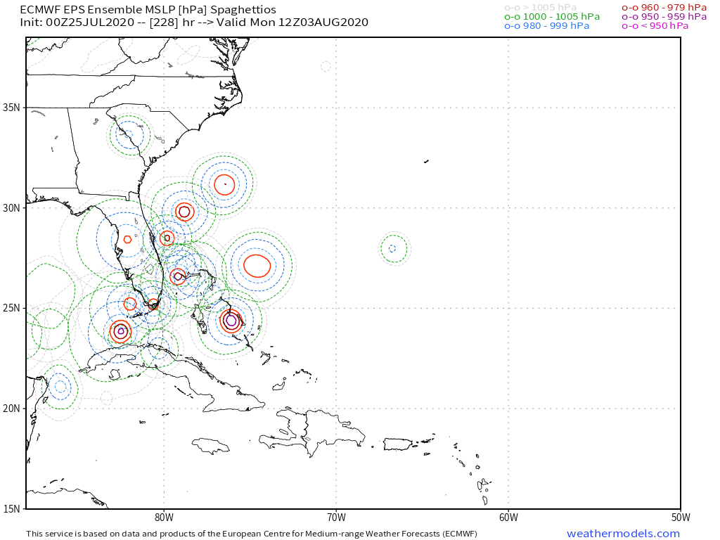
Yeah 00z Euro Ensembles (EPS) are slightly more bullish when compared to yesterday’s afternoon 12z Ensembles. Though there’s two camps: those that strengthen 92L move it north of Hispaniola into the Bahamas and towards the SE U.S., while the weaker solutions show a Caribbean cruiser a lot like the operational run this morning.

3 likes

-
AxaltaRacing24
- Category 5

- Posts: 1774
- Age: 25
- Joined: Wed Jul 27, 2016 11:14 am
- Location: Jupiter, FL

Re: ATL: INVEST 92L - Models
I can’t be the only one getting Dorian vibes from that track. Starts as a low rider in the MDR, pulls north at the Lesser Antilles, passes through the Greater Antilles, and heads into the Bahamas.
5 likes
Irene '11 Sandy '12 Hermine '16 5/15/2018 Derecho Fay '20 Isaias '20 Elsa '21 Henri '21 Ida '21
I am only a meteorology enthusiast who knows a decent amount about tropical cyclones. Look to the professional mets, the NHC, or your local weather office for the best information.
I am only a meteorology enthusiast who knows a decent amount about tropical cyclones. Look to the professional mets, the NHC, or your local weather office for the best information.
-
northjaxpro

- S2K Supporter

- Posts: 8900
- Joined: Mon Sep 27, 2010 11:21 am
- Location: Jacksonville, FL
Re: ATL: INVEST 92L - Models
We will be watching very nervously for them and here anywhere on the Southeast U.S. Coast in the next 7-10 days.
The timing with a trough that will be positioned over the Northeast U.S. in the next 7-10 days, and where exactly in relation to where Isaias will be is going to be very critical as to the eventual path down the road.
Last edited by northjaxpro on Sat Jul 25, 2020 5:58 am, edited 4 times in total.
0 likes
NEVER, EVER SAY NEVER in the tropics and weather in general, and most importantly, with life itself!!
________________________________________________________________________________________
Fay 2008 Beryl 2012 Debby 2012 Colin 2016 Hermine 2016 Julia 2016 Matthew 2016 Irma 2017 Dorian 2019
________________________________________________________________________________________
Fay 2008 Beryl 2012 Debby 2012 Colin 2016 Hermine 2016 Julia 2016 Matthew 2016 Irma 2017 Dorian 2019
Re: ATL: INVEST 92L - Models
With their latest runs, the GFS and CMC are finally on board with development, and both are fairly aggressive when future Isaias gets north of the Greater Antilles. Euro is weaker, but the storm is still clearly there and develops around the same time.
Based on the model consensus, Isaias will develop sometime between late Monday and early Wednesday. It will reach the islands at around 120-ish hours. Like what was mentioned before, a weaker storm will stay further south (Euro), while a stronger one will get pulled to the north (GFS and CMC). The former scenario could potentially lead to a powerful hurricane in the W Carib/Gulf down the line, and the latter scenario could have a hurricane blowing up near the Bahamas and/or Florida.
Based on the model consensus, Isaias will develop sometime between late Monday and early Wednesday. It will reach the islands at around 120-ish hours. Like what was mentioned before, a weaker storm will stay further south (Euro), while a stronger one will get pulled to the north (GFS and CMC). The former scenario could potentially lead to a powerful hurricane in the W Carib/Gulf down the line, and the latter scenario could have a hurricane blowing up near the Bahamas and/or Florida.
2 likes
Irene '11 Sandy '12 Hermine '16 5/15/2018 Derecho Fay '20 Isaias '20 Elsa '21 Henri '21 Ida '21
I am only a meteorology enthusiast who knows a decent amount about tropical cyclones. Look to the professional mets, the NHC, or your local weather office for the best information.
I am only a meteorology enthusiast who knows a decent amount about tropical cyclones. Look to the professional mets, the NHC, or your local weather office for the best information.
-
Shell Mound
- Category 5
- Posts: 2432
- Age: 33
- Joined: Thu Sep 07, 2017 3:39 pm
- Location: St. Petersburg, FL → Scandinavia
Re: ATL: INVEST 92L - Models
aspen wrote:a weaker storm will stay further south (Euro)
Actually, the operational ECMWF is an outlier relative to roughly half of the EC ensembles, many of which are stronger/farther N this cycle vs. yesterday’s 12Z:
Source
5 likes
CVW / MiamiensisWx / Shell Mound
The posts in this forum are NOT official forecasts and should not be used as such. They are just the opinion of the poster and may or may not be backed by sound meteorological data. They are NOT endorsed by any professional institution or STORM2K. For official information, please refer to products from the NHC and NWS.
-
northjaxpro
- S2K Supporter
- Posts: 8900
- Joined: Mon Sep 27, 2010 11:21 am
- Location: Jacksonville, FL
Re: ATL: INVEST 92L - Models
You beat me to posting about this very point. EURO and decent number of its ensembles have gone stronger and poleward with future Isaias for that Aug 2 timeframe.
Last edited by northjaxpro on Sat Jul 25, 2020 6:16 am, edited 5 times in total.
0 likes
NEVER, EVER SAY NEVER in the tropics and weather in general, and most importantly, with life itself!!
________________________________________________________________________________________
Fay 2008 Beryl 2012 Debby 2012 Colin 2016 Hermine 2016 Julia 2016 Matthew 2016 Irma 2017 Dorian 2019
________________________________________________________________________________________
Fay 2008 Beryl 2012 Debby 2012 Colin 2016 Hermine 2016 Julia 2016 Matthew 2016 Irma 2017 Dorian 2019

Re: ATL: INVEST 92L - Models
UKmet remains bullish, but confidence is not very high this far out

0 likes
Very useful information on the Dvorak Technique --
https://severe.worldweather.wmo.int/TCF ... kBeven.pdf
https://severe.worldweather.wmo.int/TCF ... kBeven.pdf
Re: ATL: INVEST 92L - Models
If the northward track through the Greater Antilles verifies, we could be looking at a very Dorian-like scenario where how strong Isaias becomes heavily depends on if the center passes between the islands. The ICON won out with Dorian and successfully predicted a safe passage between PR and the Virgin Islands. However, we’ll need to wait a few days for this to actually develop to have a better idea on these pretty tiny track differences.
1 likes
Irene '11 Sandy '12 Hermine '16 5/15/2018 Derecho Fay '20 Isaias '20 Elsa '21 Henri '21 Ida '21
I am only a meteorology enthusiast who knows a decent amount about tropical cyclones. Look to the professional mets, the NHC, or your local weather office for the best information.
I am only a meteorology enthusiast who knows a decent amount about tropical cyclones. Look to the professional mets, the NHC, or your local weather office for the best information.
-
OuterBanker
- S2K Supporter
- Posts: 1761
- Joined: Wed Feb 26, 2003 10:53 am
- Location: Nags Head, NC
- Contact:
Re: ATL: INVEST 92L - Discussion
ITheStormExpert wrote:Yeah 00z Euro Ensembles (EPS) are slightly more bullish when compared to yesterday’s afternoon 12z Ensembles. Though there’s two camps: those that strengthen 92L move it north of Hispaniola into the Bahamas and towards the SE U.S., while the weaker solutions show a Caribbean cruiser a lot like the operational run this morning.
https://i.ibb.co/m5XH37F/50-B1-C5-CA-55-D0-431-C-95-C4-EA0-A9-D02-A957.png
How interesting. At first I thought the light green was a tropical storm. The I read the legend and realized the yellowish green was a hurricane.
2 likes
-
HurricaneFrances04
- Category 2

- Posts: 597
- Joined: Mon Jun 25, 2012 8:09 am
- Location: Fort Lauderdale, Florida
Re: ATL: INVEST 92L - Models
5 likes
Who is online
Users browsing this forum: No registered users and 117 guests