HMON 908mb...
HWRF is at 945...
ATL: IOTA - Models
Moderator: S2k Moderators
-
AutoPenalti
- Category 5

- Posts: 4091
- Age: 29
- Joined: Mon Aug 17, 2015 4:16 pm
- Location: Ft. Lauderdale, Florida
Re: ATL: INVEST 98L - Models
0 likes
The posts in this forum are NOT official forecasts and should not be used as such. They are just the opinion of the poster and may or may not be backed by sound meteorological data. They are NOT endorsed by any professional institution or STORM2K. For official information, please refer to products from the NHC and NWS.
Model Runs Cheat Sheet:
GFS (5:30 AM/PM, 11:30 AM/PM)
HWRF, GFDL, UKMET, NAVGEM (6:30-8:00 AM/PM, 12:30-2:00 AM/PM)
ECMWF (1:45 AM/PM)
TCVN is a weighted averaged
-
SouthFLTropics

- Category 5
- Posts: 4258
- Age: 50
- Joined: Thu Aug 14, 2003 8:04 am
- Location: Port St. Lucie, Florida
Re: ATL: INVEST 98L - Models
HMON ends run at 908mb
Sent from my iPhone using Tapatalk
Sent from my iPhone using Tapatalk
0 likes
Fourth Generation Florida Native
Personal Storm History: David 79, Andrew 92, Erin 95, Floyd 99, Irene 99, Frances 04, Jeanne 04, Wilma 05, Matthew 16, Irma 17, Ian 22, Nicole 22, Milton 24
Personal Storm History: David 79, Andrew 92, Erin 95, Floyd 99, Irene 99, Frances 04, Jeanne 04, Wilma 05, Matthew 16, Irma 17, Ian 22, Nicole 22, Milton 24
-
SouthFLTropics
- Category 5
- Posts: 4258
- Age: 50
- Joined: Thu Aug 14, 2003 8:04 am
- Location: Port St. Lucie, Florida
Re: ATL: INVEST 98L - Models
Interesting that HMON and HWRF neither take a dive into Honduras.
Sent from my iPhone using Tapatalk
Sent from my iPhone using Tapatalk
3 likes
Fourth Generation Florida Native
Personal Storm History: David 79, Andrew 92, Erin 95, Floyd 99, Irene 99, Frances 04, Jeanne 04, Wilma 05, Matthew 16, Irma 17, Ian 22, Nicole 22, Milton 24
Personal Storm History: David 79, Andrew 92, Erin 95, Floyd 99, Irene 99, Frances 04, Jeanne 04, Wilma 05, Matthew 16, Irma 17, Ian 22, Nicole 22, Milton 24

Re: ATL: INVEST 98L - Models
I'm amazed at the latitude and strength of the initial runs. For a system that isn't even developed yet...
0 likes
Re: ATL: INVEST 98L - Models
AutoPenalti wrote:HMON 908mb...
HWRF is at 945...
If the storm ends up anything like this, it plus what is left to get from Eta and Theta could push this season into the top 10 in ACE.
1 likes

Re: ATL: INVEST 98L - Models
I don't think even Eta or Delta ever went below 910 mbar in any HMON run, so the fact that it does it on the first run now is very alarming. Especially considering the fact that with both Delta and Eta the storms both surpassed their initial HMON/HWRF forecasted peaks. Tbh I'd be more surprised if this didn't become a major than if it did. And I know how crazy it is that I have to say this in mid-November, but I think there is a possibility that this becomes a cat 5. Very far from a certainty since we don't even have a TD yet, but there is a possibility. I know it goes against all climatology to even talk about a cat 5 this late in November, but the conditions in the Caribbean are so favorable right now that I think it overrules the voice in the back of my head saying it's November and that a cat 5 right now is impossible. I thought Delta would become one, but we all know how that ended. Then I was sure that Eta would become one and it might have actually been a cat 5, but I think we're all familiar with Eta's story. And now in mid-November the Atlantic has probably its last shot (I mean I know this is a crazy season but it has to end at some point, right?) at a cat 5.
Last edited by kevin on Thu Nov 12, 2020 4:52 am, edited 1 time in total.
5 likes

Re: ATL: INVEST 98L - Models
06z models are rolling, let's see what happens this time. HWRF already has a hurricane on Saturday (48 hours).
0 likes
-
chris_fit

- Category 5
- Posts: 3261
- Age: 43
- Joined: Wed Sep 10, 2003 11:58 pm
- Location: Tampa Bay Area, FL
Re: ATL: INVEST 98L - Models
Just wanna say glad pretty my every models keeps this away from the US. My friends in Central America, ughhh. Hang in there, 2020 almost over.
0 likes

Re: ATL: INVEST 98L - Models
Yikes almighty, that HMOM run 
Just about every model has shifted north. Either Iota makes landfall around the Nic-Hond border, or it gets into the Gulf of Honduras. The CMC is back to showing a stronger storm, the GFS-Para took a massive northern shift, and the 06z HWRF is showing a compact/pinhole core. All the signs are now pointing towards another monster storm within the next week.
Just about every model has shifted north. Either Iota makes landfall around the Nic-Hond border, or it gets into the Gulf of Honduras. The CMC is back to showing a stronger storm, the GFS-Para took a massive northern shift, and the 06z HWRF is showing a compact/pinhole core. All the signs are now pointing towards another monster storm within the next week.
3 likes
Irene '11 Sandy '12 Hermine '16 5/15/2018 Derecho Fay '20 Isaias '20 Elsa '21 Henri '21 Ida '21
I am only a meteorology enthusiast who knows a decent amount about tropical cyclones. Look to the professional mets, the NHC, or your local weather office for the best information.
I am only a meteorology enthusiast who knows a decent amount about tropical cyclones. Look to the professional mets, the NHC, or your local weather office for the best information.

Re: ATL: INVEST 98L - Models
Models are having the same difficulty they had with Eta, surely going to become a storm and probably no luck burying it in Central American mountains before it becomes a hurricane.
2 likes

Re: ATL: INVEST 98L - Models
ClarCari wrote:I'm amazed at the latitude and strength of the initial runs. For a system that isn't even developed yet...
And for a system forming halfway through November.
0 likes
Igor 2010, Sandy 2012, Fay 2014, Gonzalo 2014, Joaquin 2015, Nicole 2016, Humberto 2019, Imelda 2025
I am only a tropical weather enthusiast. My predictions are not official and may or may not be backed by sound meteorological data. For official information, please refer to the NHC and NWS products.
I am only a tropical weather enthusiast. My predictions are not official and may or may not be backed by sound meteorological data. For official information, please refer to the NHC and NWS products.
-
supercane4867
- Category 5
- Posts: 4966
- Joined: Wed Nov 14, 2012 10:43 am


Re: ATL: INVEST 98L - Models
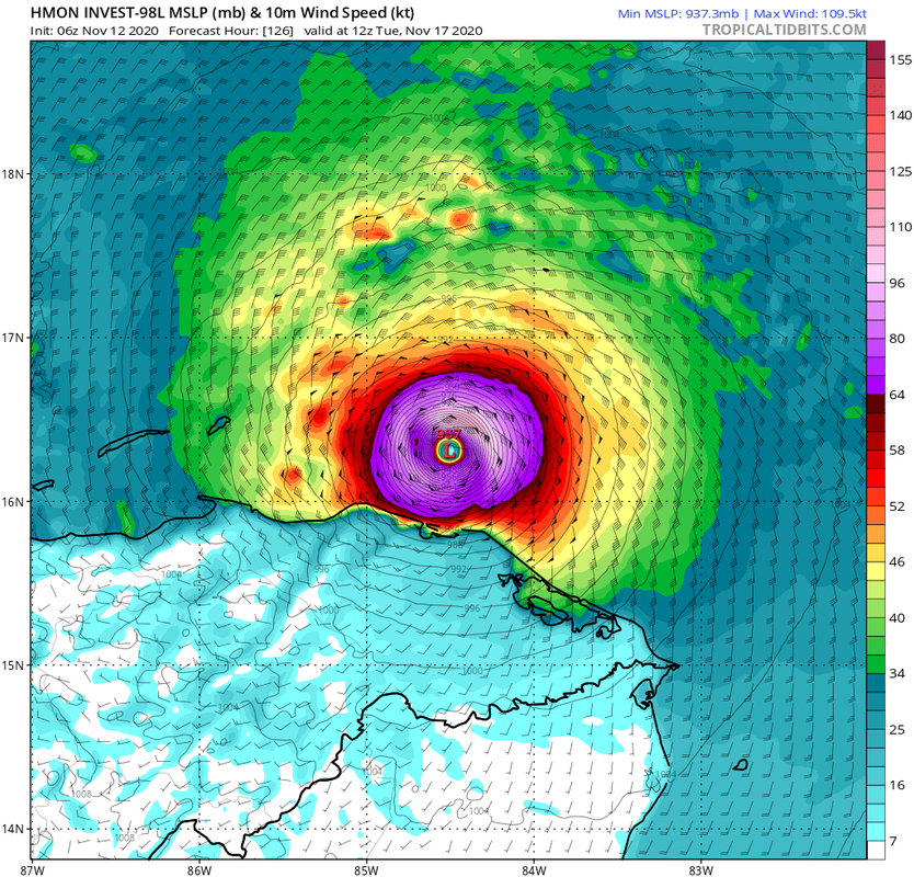
HMON
Last edited by Owasso on Thu Nov 12, 2020 7:40 am, edited 1 time in total.
0 likes
-
Loveweather12
- Tropical Storm

- Posts: 136
- Joined: Thu Aug 20, 2020 2:37 pm
Re: ATL: INVEST 98L - Models
chris_fit wrote:Just wanna say glad pretty my every models keeps this away from the US. My friends in Central America, ughhh. Hang in there, 2020 almost over.
To early to make that assumption as things can change.
2 likes
Re: ATL: INVEST 98L - Models
06z HWRF and HMON aren’t as strong as the 00z runs, but they both show compact to normal-sized cores and bottom out at 932 mbar and 952 mbar, respectively.
0 likes
Irene '11 Sandy '12 Hermine '16 5/15/2018 Derecho Fay '20 Isaias '20 Elsa '21 Henri '21 Ida '21
I am only a meteorology enthusiast who knows a decent amount about tropical cyclones. Look to the professional mets, the NHC, or your local weather office for the best information.
I am only a meteorology enthusiast who knows a decent amount about tropical cyclones. Look to the professional mets, the NHC, or your local weather office for the best information.
Re: ATL: INVEST 98L - Models
Just took a look at the Eta models thread. The first HWRF and HMON runs had 937 and 947 mbar, respectively. So quite similar to today's runs so far.
0 likes
-
tolakram
- Admin

- Posts: 20178
- Age: 62
- Joined: Sun Aug 27, 2006 8:23 pm
- Location: Florence, KY (name is Mark)
Re: ATL: INVEST 98L - Models
Euro now has a stronger storm, GFS loses it, HWRF strong and north. What a year for the models. At least the euro is mostly trustworthy at less than 120 hours. Mostly, but not always.
0 likes
M a r k
- - - - -
Join us in chat: Storm2K Chatroom Invite. Android and IOS apps also available.
The posts in this forum are NOT official forecasts and should not be used as such. Posts are NOT endorsed by any professional institution or STORM2K.org. For official information and forecasts, please refer to NHC and NWS products.
Re: ATL: INVEST 98L - Models
tolakram wrote:Euro now has a stronger storm, GFS loses it, HWRF strong and north. What a year for the models. At least the euro is mostly trustworthy at less than 120 hours. Mostly, but not always.
The GFS also loses everything from 54-168 hours out, because apparently asking a model to load correctly is too much in 2020.
2 likes
Irene '11 Sandy '12 Hermine '16 5/15/2018 Derecho Fay '20 Isaias '20 Elsa '21 Henri '21 Ida '21
I am only a meteorology enthusiast who knows a decent amount about tropical cyclones. Look to the professional mets, the NHC, or your local weather office for the best information.
I am only a meteorology enthusiast who knows a decent amount about tropical cyclones. Look to the professional mets, the NHC, or your local weather office for the best information.
Who is online
Users browsing this forum: No registered users and 46 guests